Overview
|
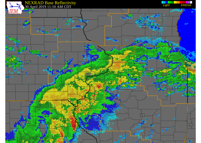
Several rounds of heavy rain and thunderstorms occurred across the region over the past week, which lead to increasing river levels along local rivers. Along the Mississippi, a new, preliminary historic crest of 22.7 feet was achieved on the afternoon of May 2, 2019 at Rock Island Lock & Dam 15, as runoff from the heavy rain and flow from tributaries worked into the river. A failure of a flood protection barrier occurred in Davenport, IA near River Drive and Pershing Ave on April 30th. This failure caused rapid rises that affected many businesses. A summary of this breach can be found here. |
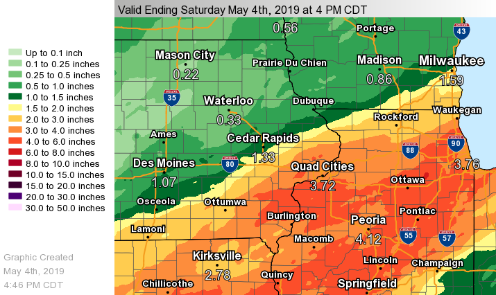 Regional 7-day Rainfall |
Storm Reports
| Interactive Storm Report Map | |
 |
|
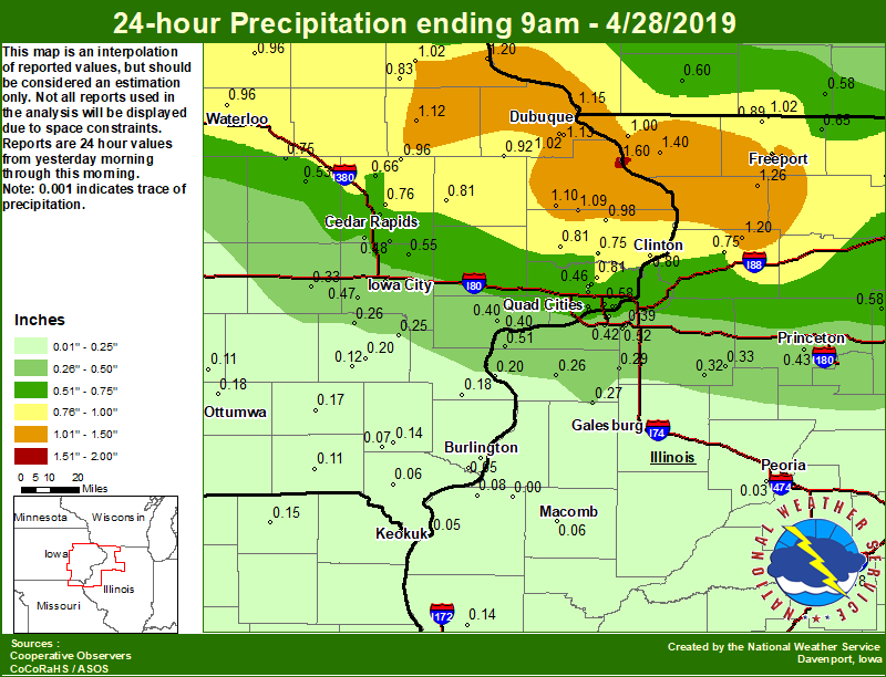
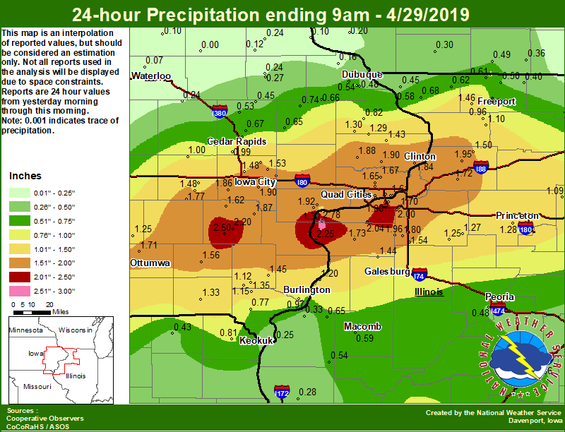
Public Information Statement National Weather Service Quad Cities IA IL 305 PM CDT Mon Apr 29 2019 ...Highest Precipitation Reports Past 24 Hours... Location Amount Time/Date Provider Illinois City 6.7 SW 2.78 in 0715 AM 04/29 COCORAHS Quad City Intl Arpt 2.68 in 0252 PM 04/29 ASOS Washington Arpt 2.67 in 0255 PM 04/29 AWOS Wapello 0.2 S 2.57 in 1000 AM 04/29 COCORAHS Henderson River 2.55 in 0200 PM 04/29 HADS Washington 5.8 SW 2.50 in 0600 AM 04/29 COCORAHS Mississippi River 2.47 in 0240 PM 04/29 COOP Atkinson 2.6 NNE 2.44 in 0800 AM 04/29 COCORAHS Milan 2.43 in 0258 PM 04/29 CWOP New London 2.39 in 0252 PM 04/29 CWOP Muscatine 2.31 in 0255 PM 04/29 CWOP Muscatine 2.6 NNE 2.29 in 0900 AM 04/29 COCORAHS Wapsipinicon River 2.23 in 0230 PM 04/29 HADS Iowa City 1.1 SE 2.10 in 0700 AM 04/29 COCORAHS Morrison 2.08 in 0256 PM 04/29 CWOP Milan 8.8 SSW 2.04 in 0700 AM 04/29 COCORAHS Iowa City 2.03 in 0252 PM 04/29 CWOP Morning Sun 1.7 E 2.03 in 0800 AM 04/29 COCORAHS Coal Valley 1.9 SE 2.00 in 0700 AM 04/29 COCORAHS Rock River 2.00 in 0230 PM 04/29 HADS New Windsor 2.0 N 1.96 in 0800 AM 04/29 COCORAHS Morrison 3.2 E 1.95 in 0700 AM 04/29 COCORAHS Sigourney 1.95 in 0800 AM 04/29 COOP Sterling 4.9 WSW 1.94 in 0830 AM 04/29 COCORAHS Iowa City Arpt 1.94 in 0252 PM 04/29 ASOS Dam 13 1.92 in 0210 PM 04/29 COOP Muscatine 2.1 N 1.92 in 0700 AM 04/29 COCORAHS Le Claire 1.8 NNE 1.92 in 0930 AM 04/29 COCORAHS De Witt 1.90 in 0800 AM 04/29 COOP Pope Creek 1.90 in 0230 PM 04/29 HADS Goose Lake 6.4 SSW 1.89 in 0700 AM 04/29 COCORAHS Calamus 2.0 NE 1.88 in 0700 AM 04/29 COCORAHS Cedar Creek 1.88 in 0230 PM 04/29 HADS Ainsworth 7.4 N 1.87 in 0700 AM 04/29 COCORAHS Hoover Creek 1.87 in 0145 PM 04/29 HADS Como 1.86 in 0230 PM 04/29 HADS Kalona 7.3 NNW 1.86 in 0700 AM 04/29 COCORAHS Camanche 1.2 W 1.84 in 0700 AM 04/29 COCORAHS Morrison 1.83 in 0259 PM 04/29 AWS Princeton 1.81 in 0246 PM 04/29 CWOP Moline 0.7 NNE 1.81 in 0700 AM 04/29 COCORAHS Davenport Arpt 1.81 in 0252 PM 04/29 ASOS Mississippi River 1.80 in 0200 PM 04/29 HADS Coralville 1.4 S 1.80 in 0800 AM 04/29 COCORAHS Alpha 2.3 N 1.80 in 0700 AM 04/29 COCORAHS Moline 1.0 WNW 1.80 in 0700 AM 04/29 COCORAHS Muscatine 1.79 in 0700 AM 04/29 COOP Edwards River 1.79 in 0230 PM 04/29 HADS Coralville 1.3 SE 1.77 in 0700 AM 04/29 COCORAHS Clinton Arpt 1.77 in 0256 PM 04/29 AWOS North English 1.77 in 0700 AM 04/29 COOP Nichols 3.2 SSW 1.76 in 0700 AM 04/29 COCORAHS Aledo 1.73 in 0700 AM 04/29 COOP Prophetstown 0.2 SW 1.72 in 0700 AM 04/29 COCORAHS Aledo 1.71 in 0245 PM 04/29 CWOP Sterling 1.70 in 0259 PM 04/29 CWOP Coal Valley 2.6 E 1.70 in 0600 AM 04/29 COCORAHS Fairfield Arpt 1.70 in 0255 PM 04/29 AWOS Park View 0.2 WSW 1.67 in 0700 AM 04/29 COCORAHS Mississippi River 1.67 in 0230 PM 04/29 HADS 2 N Muscatine 1.67 in 0700 AM 04/29 COOP West Branch 2.0 NNW 1.65 in 0700 AM 04/29 COCORAHS Eldridge 0.7 SSW 1.65 in 0800 AM 04/29 COCORAHS Davenport 0.9 SSW 1.65 in 0700 AM 04/29 COCORAHS Bettendorf 2.2 SE 1.64 in 0645 AM 04/29 COCORAHS West Liberty 0.7 NNW 1.62 in 0700 AM 04/29 COCORAHS Davenport 0.9 WNW 1.62 in 0700 AM 04/29 COCORAHS Wellman 4.0 E 1.62 in 0625 AM 04/29 COCORAHS Riverdale 0.5 N 1.61 in 0700 AM 04/29 COCORAHS Woodhull 4.9 E 1.61 in 0800 AM 04/29 COCORAHS Eldridge 1.60 in 0246 PM 04/29 CWOP Milledgeville 0.6 NW 1.60 in 0800 AM 04/29 COCORAHS Bettendorf 1.6 WSW 1.59 in 0700 AM 04/29 COCORAHS Tiffin 1.8 SW 1.55 in 0216 PM 04/29 COCORAHS , IL 1.55 in 0830 AM 04/29 COCORAHS Woodhull 0.3 ESE 1.54 in 0700 AM 04/29 COCORAHS Iowa City 8.0 NE 1.53 in 0712 AM 04/29 COCORAHS Fairfield 1.52 in 0700 AM 04/29 AWOS Solon 0.3 ESE 1.52 in 0600 AM 04/29 COCORAHS Davenport 1.51 in 0245 PM 04/29 CWOP Muscatine 5.2 NE 1.51 in 0800 AM 04/29 COCORAHS Coleta 1.4 SSW 1.50 in 0700 AM 04/29 COCORAHS Parnell 0.1 SSW 1.48 in 0539 AM 04/29 COCORAHS North Liberty 0.7 SSW 1.48 in 0800 AM 04/29 COCORAHS Pearl City 0.4 SW 1.46 in 0700 AM 04/29 COCORAHS New London 1.5 SW 1.45 in 0700 AM 04/29 COCORAHS Mount Carroll 1.45 in 0945 AM 04/29 COOP Alexis 1.44 in 0700 AM 04/29 COOP Charlotte 1.9 WNW 1.43 in 0700 AM 04/29 COCORAHS North Skunk River 1.41 in 0230 PM 04/29 HADS Savanna 4.6 N 1.40 in 0700 AM 04/29 COCORAHS Big Bureau Creek 1.39 in 0200 PM 04/29 HADS West Point 7.5 NW 1.35 in 0700 AM 04/29 COCORAHS Des Moines River 1.34 in 0200 PM 04/29 HADS Princeton 1.1 SE 1.30 in 0700 AM 04/29 COCORAHS Maquoketa 1.30 in 0700 AM 04/29 COOP 1 E Williamsburg 1.30 in 0700 AM 04/29 COOP Delmar 2.3 NW 1.29 in 0700 AM 04/29 COCORAHS Swisher 0.4 NNE 1.28 in 0738 AM 04/29 COCORAHS Tiskilwa 2.1 N 1.28 in 0700 AM 04/29 COCORAHS Swisher 1.28 in 0738 AM 04/29 COOP Kewanee 1 E 1.27 in 0700 AM 04/29 COOP Burlington 0.8 SSE 1.26 in 0909 AM 04/29 COCORAHS Galva 2.7 NE 1.25 in 0600 AM 04/29 COCORAHS , IL 1.22 in 0800 AM 04/29 COCORAHS Olin 1.20 in 0245 PM 04/29 CWOP Mt. Carroll 1.19 in 0257 PM 04/29 CWOP Green R At 1.18 in 0230 PM 04/29 COOP Freeport 1.17 in 0253 PM 04/29 CWOP Clear Creek 1.15 in 0215 PM 04/29 HADS Mount Vernon 0.7 ENE 1.14 in 0805 AM 04/29 COCORAHS Mount Pleasant Arpt 1.13 in 0255 PM 04/29 AWOS Stronghurst 1.12 in 0254 PM 04/29 CWOP Williamsburg 1.12 in 0249 PM 04/29 CWOP Salem 3.1 ESE 1.12 in 0630 AM 04/29 COCORAHS Shimek State Forest 1.10 in 0207 PM 04/29 RAWS Lanark 6.0 E 1.10 in 0715 AM 04/29 COCORAHS Mount Carroll 6.8 NNW 1.07 in 0700 AM 04/29 COCORAHS Savanna Arpt 1.07 in 0235 PM 04/29 AWOS Cedar River 1.03 in 0200 PM 04/29 HADS Marengo 3.6 N 1.00 in 0700 AM 04/29 COCORAHS |
|
Public Information Statement National Weather Service Quad Cities IA IL 1028 AM CDT Wed May 1 2019 ...Highest Precipitation Reports Past 48 Hours... Observations are collected from a variety of sources with varying equipment and exposures. We thank all volunteer weather observers for their dedication. Not all data listed are considered official. Location Amount Time/Date Provider Dallas City 3.0 SSE 3.78 in 0600 AM 05/01 COCORAHS Geneseo 3.62 in 1200 AM 05/01 COOP Tiskilwa 2.1 N 2.78 in 0700 AM 05/01 COCORAHS New London 2.73 in 0942 AM 05/01 CWOP Princeton 1.1 SE 2.67 in 0700 AM 05/01 COCORAHS Prophetstown 0.2 SW 2.35 in 0700 AM 05/01 COCORAHS Big Bureau Crk at Princeton 2.34 in 0945 AM 05/01 HADS Henderson River at Oquawka 2.29 in 0900 AM 05/01 HADS New Windsor 2.0 N 2.12 in 0700 AM 05/01 COCORAHS Burlington 6.5 SSW 2.09 in 0700 AM 05/01 COCORAHS La Harpe 0.7 E 2.05 in 1000 AM 05/01 COCORAHS Colchester 3.5 NE 2.02 in 0700 AM 05/01 COCORAHS Fox River at Wayland 2.02 in 0930 AM 05/01 HADS Oquawka 0.5 N 1.94 in 0830 AM 05/01 COCORAHS MS RVR at Keithsburg 1.82 in 0930 AM 05/01 HADS Stronghurst 1.81 in 1014 AM 05/01 CWOP La Moine River at Colmar 1.75 in 0945 AM 05/01 HADS Ainsworth 7.4 N 1.74 in 0700 AM 05/01 COCORAHS Des Moines Rvr at Keosauqua 1.68 in 0900 AM 05/01 HADS Coal Valley 2.6 E 1.67 in 0700 AM 05/01 COCORAHS Cedar Crk near Oakland Mills 1.67 in 0930 AM 05/01 HADS Coleta 1.4 SSW 1.49 in 0700 AM 05/01 COCORAHS Macomb Arpt 1.49 in 1015 AM 05/01 AWOS Eldridge 0.7 SSW 1.46 in 0800 AM 05/01 COCORAHS Edwards River at New Boston 1.44 in 0930 AM 05/01 HADS Shimek State Forest 1.41 in 1007 AM 05/01 RAWS Camanche 1.2 W 1.40 in 0700 AM 05/01 COCORAHS Wapsi Rvr near De Witt 1.36 in 0930 AM 05/01 COOP Muscatine 1.36 in 1015 AM 05/01 CWOP Davenport 1.35 in 1015 AM 05/01 CWOP North Skunk Rvr at Sigourney 1.31 in 0930 AM 05/01 HADS Quad City Intl Arpt 1.30 in 0952 AM 05/01 ASOS Keokuk Arpt 1.23 in 1015 AM 05/01 AWOS Como 1.22 in 0930 AM 05/01 HADS Shannon 0.2 S 1.22 in 0700 AM 05/01 COCORAHS Freeport 1.7 NW 1.21 in 0649 AM 05/01 COCORAHS Le Claire 1.8 NNE 1.20 in 0700 AM 05/01 COCORAHS Aledo 1.16 in 1015 AM 05/01 CWOP Charlotte 1.9 WNW 1.11 in 0700 AM 05/01 COCORAHS Freeport 2.0 NW 1.10 in 0700 AM 05/01 COCORAHS Davis 0.5 N 1.07 in 0630 AM 05/01 COCORAHS Freeport 2.9 WSW 1.06 in 0730 AM 05/01 COCORAHS Mount Carroll 6.8 NNW 1.05 in 0700 AM 05/01 COCORAHS |
|
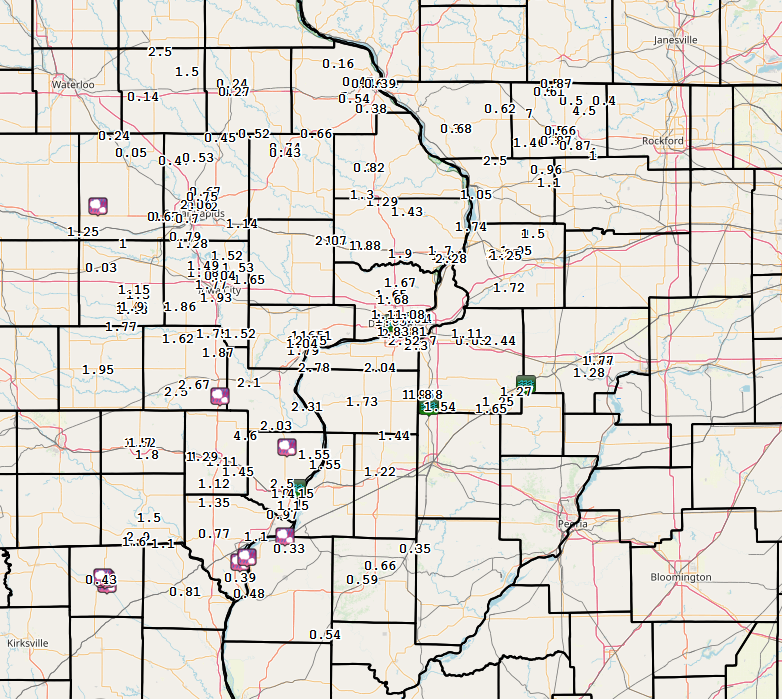
Rain Reports
 |
 |
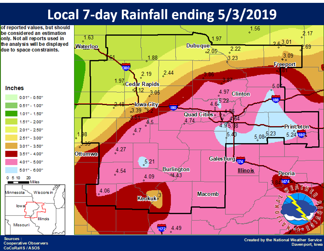 |
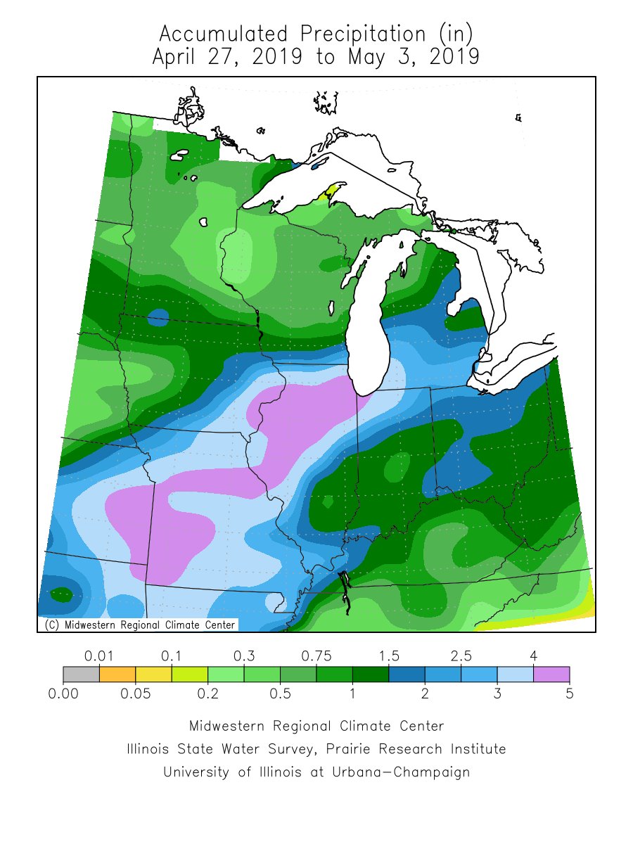
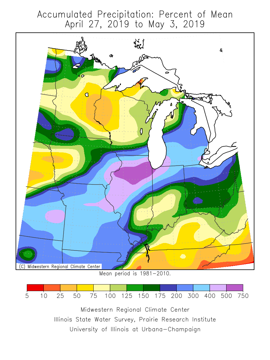
| Midwest Regional Climate Center 7-day Rainfall | Midwest Regional Climate Center 7-day Percent of Normal | Local 7 day Rainfall |
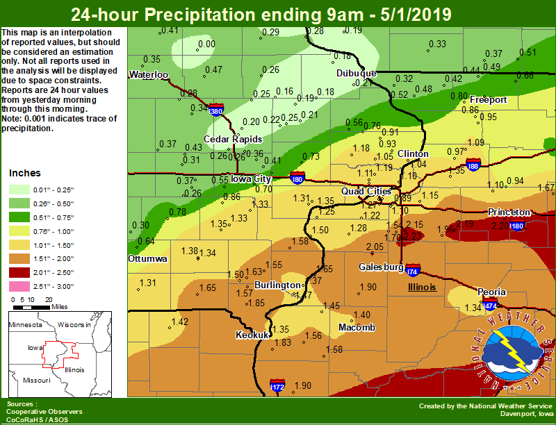
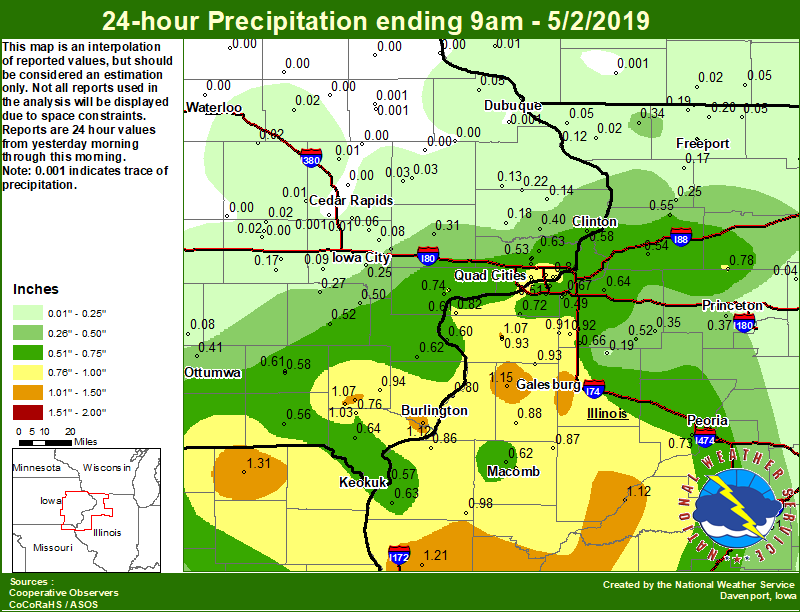
Daily Rainfall Amounts: April 28 - May 3
 |
 |
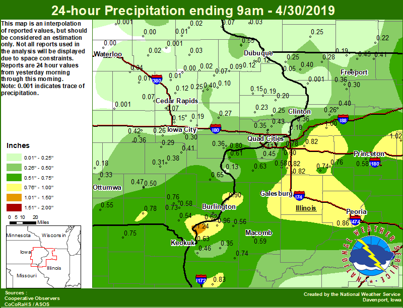 |
| Local 24-hr Rainfall 4/28/19 | Local 24-hr Rainfall 4/29/19 | Local 24-hr Rainfall 4/30/19 |
 |
 |
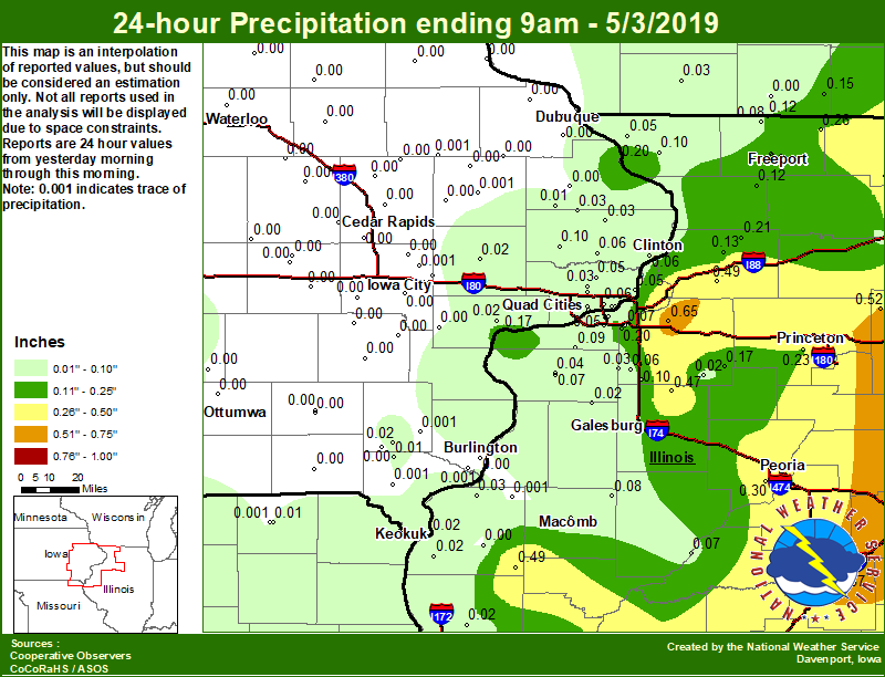 |
| Local 24-hr Rainfall 5/1/19 | Local 24-hr Rainfall 5/2/19 | Local 24-hr Rainfall 5/3/19 |
 |
Media use of NWS Web News Stories is encouraged! Please acknowledge the NWS as the source of any news information accessed from this site. |
|