Scattered severe thunderstorms capable of damaging wind gusts and some hail are expected this afternoon and evening from the Upper Ohio River Valley into the Northeast, and from the Appalachians into the Mid-Atlantic States. Excessive rainfall from heavy thunderstorms may produce areas of flash flooding from southern New Mexico into the western and northern Gulf Coast into Wednesday. Read More >
Overview
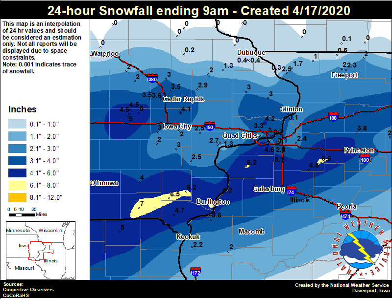
A late season snow storm brought heavy wet snow to portions of southeast Iowa, extreme northeast Missouri and
northwest Illinois April 16 and 17. With warm ground temperatures, there were not many impacts to travel other than
reduced visibility at times and minor slushy accumulations on roads. The higher amounts of 5 to 8 inches fell from the
Fairfield and Keosauqua areas in southeastern Iowa northeast toward Aledo and Kewanee in Illinois.
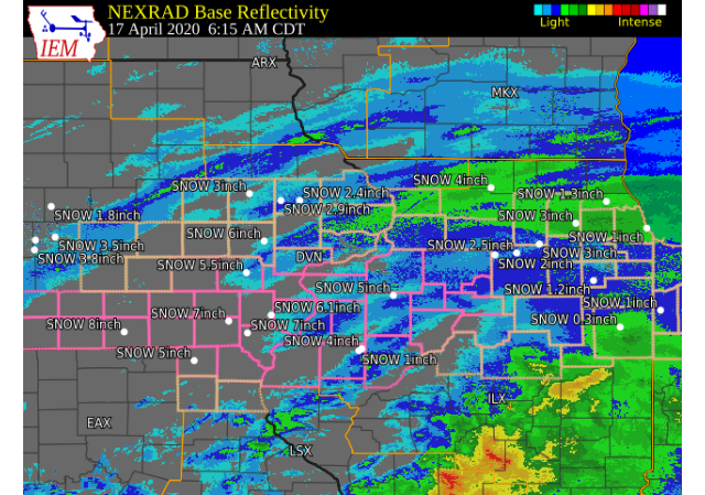
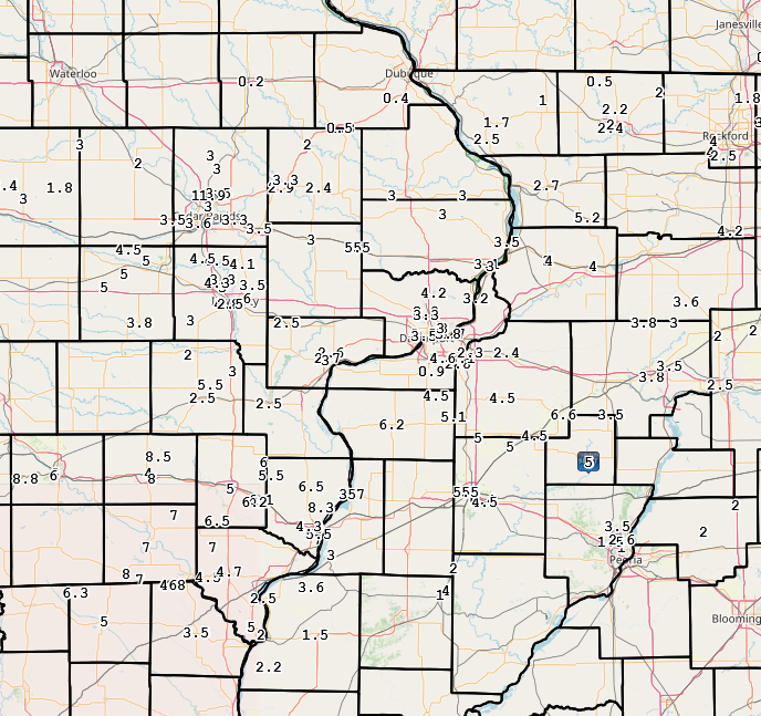
| Local Snow Map | Interactive Snow Report Map | Regional Snow Map |
 |
 |
 |
Storm Reports
|
PRELIMINARY LOCAL STORM REPORT...SUMMARY ..TIME... ...EVENT... ...CITY LOCATION... ...LAT.LON... 0559 AM SNOW 1 W PERLEE 41.08N 91.91W MEASURED 8.5 INCHES, LESS DEPTH ON SIDEWALKS 0733 AM SNOW 5 SSE SPERRY 40.89N 91.10W
0901 AM SNOW CANTRIL 40.64N 92.07W
0845 AM SNOW 2 ESE FAIRFIELD 41.00N 91.94W
0709 AM SNOW 3 W MOUNT STERLING 40.62N 92.00W
0700 AM SNOW KEOSAUQUA 40.74N 91.97W
0500 AM SNOW 1 ESE BURLINGTON REGION 40.77N 91.12W CO-OP OBSERVER STATION BLGI4 BURLINGTON 2S. 0700 AM SNOW 1 E KEWANEE 41.24N 89.90W CO-OP OBSERVER STATION KEWI2 KEWANEE 1 E. 0803 AM SNOW 1 N SPERRY 40.97N 91.15W
0700 AM SNOW 1 S SALEM 40.84N 91.62W CO-OP OBSERVER STATION SLHI4 SALEM 1 S. 0725 AM SNOW 3 WNW HITT 40.57N 92.32W LOCATION ESTIMATED. FORMER SPOTTER. 0701 AM SNOW 2 SW NEW LONDON 40.91N 91.43W
0700 AM SNOW ALEDO 41.20N 90.75W CO-OP OBSERVER STATION ALEI2 ALEDO. 0924 AM SNOW MOUNT UNION 41.06N 91.39W UNOFFICIAL MEASUREMENT OF 6 INCHES. 0730 AM SNOW 3 ENE CHARLIE HEATH MEM 40.60N 91.84W UPDATES PREVIOUS SNOW REPORT FROM 3 ENE 0629 AM SNOW 4 E IOWA CITY 41.67N 91.47W
0950 AM SNOW LOWDEN 41.86N 90.92W UPDATES PREVIOUS SNOW REPORT FROM LOWDEN. 0755 AM SNOW 2 SW YARMOUTH 41.01N 91.35W
0619 AM SNOW 4 NE WASHINGTON 41.35N 91.65W
0700 AM SNOW 2 NNE NEW WINDSOR 41.23N 90.44W COCORAHS STATION IL-HY-6 NEW WINDSOR 2.0 N. 0908 AM SNOW 1 SSW MOOAR 40.44N 91.45W
0900 AM SNOW OQUAWKA 40.94N 90.95W
0843 AM SNOW 2 W GENOA BLUFF 41.71N 92.18W
0802 AM SNOW MOUNT PLEASANT 40.96N 91.55W
0700 AM SNOW 3 SSW MARENGO 41.76N 92.08W COCORAHS STATION IA-IA-2 MARENGO 2.6 SSW. 0700 AM SNOW 1 NNE WEST AMANA 41.81N 91.97W COCORAHS STATION IA-IA-6 AMANA 4.7 W. 0600 AM SNOW 1 WSW MEMPHIS 40.46N 92.18W CO-OP OBSERVER STATION MMPM7 MEMPHIS. 0550 AM SNOW 1 W MEMPHIS 40.46N 92.18W
0635 AM SNOW 1 SW UNIVERSITY HEIGHTS 41.65N 91.57W ZERO ON PAVEMENT. 0700 AM SNOW DONNELLSON 40.65N 91.56W CO-OP OBSERVER STATION DNNI4 DONNELLSON. 0823 AM SNOW MILLEDGEVILLE 41.97N 89.78W
0700 AM SNOW MOLINE QUAD-CITY AIRPOR 41.45N 90.50W
0920 AM SNOW 1 WSW SHERRARD 41.31N 90.53W
0847 AM SNOW 1 W COU FALLS 41.82N 91.69W
0844 AM SNOW CAMBRIDGE 41.30N 90.20W
0817 AM SNOW 3 E COU FALLS 41.81N 91.62W
0700 AM SNOW 4 N MARENGO 41.85N 92.06W COCORAHS STATION IA-IA-18 MARENGO 3.6 N. 0645 AM SNOW GALVA 41.16N 90.04W COCORAHS STATION IL-HY-22 , IL. 0645 AM SNOW 4 NNE CROTON 40.63N 91.66W
0850 AM SNOW 1 E WEST BURLINGTON 40.82N 91.16W
0717 AM SNOW 1 SW NORTH LIBERTY 41.73N 91.62W HEAVY SNOW, QUICKLY MELTING. 0700 AM SNOW PARK VIEW 41.69N 90.54W COCORAHS STATION IA-ST-3 PARK VIEW 0.2 WSW. 0733 AM SNOW SOLON 41.80N 91.49W
0700 AM SNOW SOLON 41.80N 91.49W COCORAHS STATION IA-JH-1 SOLON 0.3 ESE. 0800 AM SNOW 1 NNE FAIRFIELD 41.02N 91.96W CO-OP OBSERVER STATION FRFI4 FAIRFIELD. 0755 AM SNOW 1 S GRIMES ADDITION 41.79N 89.75W
0700 AM SNOW 1 N RIVERDALE 41.54N 90.47W COCORAHS STATION IA-ST-42 RIVERDALE 0.5 N. 0700 AM SNOW PRINCETON 41.38N 89.46W CO-OP OBSERVER STATION PTNI2 PRINCETON. 0700 AM SNOW 3 NW OHIO 41.58N 89.50W COCORAHS STATION IL-BU-11 WALNUT 5.3 ENE. 0516 AM SNOW PARNELL 41.58N 92.00W
0700 AM SNOW 1 ENE RIVERDALE 41.54N 90.45W COCORAHS STATION IA-ST-8 BETTENDORF 2.2 SE. 0715 AM SNOW 2 SW CEDAR RAPIDS 41.95N 91.71W SNOW ON GRASS/ELEVATED SURFACES. 0700 AM SNOW 2 NE COLUSA 40.59N 91.15W TEMP @ 7:00 AM WAS 32 DEGREES F. WITH CLOUDY 0907 AM SNOW MALDEN 41.42N 89.37W FORMER SPOTTER NEAR MALDEN. 0831 AM SNOW 1 W LOMBARDVILLE 41.24N 89.66W
0812 AM SNOW 1 ENE MOUNT VERNON 41.93N 91.41W
0757 AM SNOW 1 NW FULTON 41.88N 90.18W
0748 AM SNOW KAHOKA 40.42N 91.72W A LOT OF MELTING HAS OCCURRED. 0700 AM SNOW 3 SSE ATKINS 41.96N 91.84W COCORAHS STATION IA-BT-12 FAIRFAX 4.0 NW. 0700 AM SNOW 2 SSE DAVENPORT 41.53N 90.59W COCORAHS STATION IA-ST-4 DAVENPORT 0.9 SSW. 0633 AM SNOW 2 NNW MARION 42.06N 91.61W COCORAHS STATION IA-LN-27 MARION 1.7 NNW. 0826 AM SNOW ANAMOSA 42.11N 91.28W
0716 AM SNOW 1 ESE NORTH LIBERTY 41.74N 91.59W
0705 AM SNOW BERTRAM 41.96N 91.53W
0700 AM SNOW DAVENPORT AIRPORT 41.61N 90.58W
0900 AM SNOW 1 SSW CORDOVA 41.67N 90.33W STORM TOTAL. 0700 AM SNOW CAMANCHE 41.80N 90.28W COCORAHS STATION IA-CN-5 CAMANCHE 1.2 W. 0700 AM SNOW 2 NNW WARNER 41.45N 90.40W COCORAHS STATION IL-HY-15 COAL VALLEY 2.6 E. 0933 AM SNOW 2 SE CARMAN 40.71N 91.05W
0930 AM SNOW CAMANCHE 41.79N 90.26W STORM TOTAL. 0908 AM SNOW STANWOOD 41.89N 91.15W
0900 AM SNOW 2 N VAN ORIN 41.58N 89.35W
0857 AM SNOW 1 W MORRISON 41.81N 89.98W
0843 AM SNOW PRESTON 42.05N 90.40W
0740 AM SNOW 2 NNW MUSCATINE 41.44N 91.08W
0730 AM SNOW 2 W BETTENDORF 41.56N 90.51W COCORAHS STATION IA-ST-48 , IA. 0700 AM SNOW 2 WNW CHARLOTTE 41.98N 90.50W COCORAHS STATION IA-CN-17 CHARLOTTE 1.9 WNW. 0700 AM SNOW 1 W MAQUOKETA MUNICIPAL 42.05N 90.75W CO-OP OBSERVER STATION MKTI4 MAQUOKETA. 0700 AM SNOW 4 NNE LAFAYETTE 42.20N 91.65W COCORAHS STATION IA-LN-7 CENTRAL CITY 6.7 W. 0700 AM SNOW 2 NNW WILLIAMSTOWN 41.59N 91.75W COCORAHS STATION IA-JH-9 KALONA 7.3 NNW. 0700 AM SNOW 4 N HASKINS 41.40N 91.54W COCORAHS STATION IA-WS-2 AINSWORTH 7.4 N. 0649 AM SNOW 1 NE OAKDALE 41.71N 91.59W
0618 AM SNOW ALBURNETT 42.15N 91.62W STILL SNOWING VERY LIGHTLY. 0439 AM SNOW 3 NNE CEDAR RAPIDS 42.01N 91.66W
0408 AM SNOW 5 N CEDAR RAPIDS 42.05N 91.68W
0600 AM SNOW 2 ESE FAIRVIEW 42.08N 91.30W CO-OP OBSERVER STATION AMOI4 ANAMOSA 3 SSW. 0700 AM SNOW 2 SE COAL VALLEY 41.43N 90.42W COCORAHS STATION IL-HY-5 COAL VALLEY 1.9 SE. 1000 AM SNOW MOUNT CARROLL 42.09N 89.98W
0700 AM SNOW 2 N MUSCATINE 41.45N 91.07W COCORAHS STATION IA-MC-13 MUSCATINE 2.1 N. 0700 AM SNOW 4 NNE MUSCATINE 41.47N 91.05W CO-OP OBSERVER STATION MSTI4 2 N MUSCATINE. 0957 AM SNOW WASHINGTON 41.30N 91.69W FORMER SPOTTER. WET SNOW. 0800 AM SNOW COLUMBUS JUNCTION 41.28N 91.36W
0732 AM SNOW NAUVOO 40.55N 91.39W OVERNIGHT TOTAL ACCUMULATION ON COLD 0700 AM SNOW 1 SE DAVENPORT 41.54N 90.59W COCORAHS STATION IA-ST-37 DAVENPORT 0.9 WNW. 0700 AM SNOW HANOVER 42.26N 90.28W COCORAHS STATION IL-JD-6 HANOVER 0.2 NW. 0700 AM SNOW 1 NNW WEST LIBERTY 41.58N 91.27W COCORAHS STATION IA-MC-15 WEST LIBERTY 0.7 0647 AM SNOW 2 NW FREEPORT 42.30N 89.66W COCORAHS STATION IL-SP-25 FREEPORT 1.7 NW. 0608 AM SNOW 3 SW CENTER JUNCTION 42.08N 91.11W HEAVY, WET, SAGGING TREE LIMBS. 0500 AM SNOW 2 NW GENESEO 41.47N 90.18W COCORAHS STATION IL-HY-8 GENESEO 2.0 NW. 0905 AM SNOW 1 SE GREEN ROCK 41.47N 90.36W
0700 AM SNOW CEDARVILLE 42.37N 89.64W
0630 AM SNOW 1 WNW SUTTER 40.29N 91.36W COCORAHS STATION IL-HN-2 WARSAW 5.8 SE. 0825 AM SNOW KEOKUK 40.41N 91.40W
0727 AM SNOW 1 NNW MONTICELLO MUNICI 42.24N 91.17W CO-OP OBSERVER STATION MCLI4 MONTICELLO. 0700 AM SNOW DAVIS 42.43N 89.42W COCORAHS STATION IL-SP-7 DAVIS 0.5 N. 0700 AM SNOW 2 NW FREEPORT 42.31N 89.66W COCORAHS STATION IL-SP-6 FREEPORT 2.0 NW. 0700 AM SNOW 1 ENE VINTON 42.17N 92.01W CO-OP OBSERVER STATION VNTI4 VINTON. 0630 AM SNOW 3 W RICHMOND 41.46N 91.76W COCORAHS STATION IA-WS-7 WELLMAN 4.0 E. 0840 AM SNOW 2 E HIAWATHA 42.05N 91.64W
0630 AM SNOW ELIZABETH 42.32N 90.23W CO-OP OBSERVER STATION EZBI2 ELIZABETH. 0530 AM SNOW CARTHAGE 40.41N 91.13W WET ROADS. MELTING FAST. NO SNOW SOUTH OF 0700 AM SNOW 1 E CASCADE 42.30N 91.00W CO-OP OBSERVER STATION CASI4 CASCADE. 0820 AM SNOW 3 N STOCKTON 42.40N 90.00W
0615 AM SNOW BUSHNELL 40.56N 90.51W ABOUT AN INCH IN GRASS. LIQUID TOTAL WAS 0700 AM SNOW 3 NNE MC CONNELL 42.47N 89.72W COCORAHS STATION IL-SP-8 WINSLOW 4.3 ESE. 0712 AM SNOW DUBUQUE REGIONAL ARPT 42.41N 90.73W
0700 AM SNOW 1 SSE MANCHESTER 42.47N 91.45W CO-OP OBSERVER STATION MHRI4 MANCHESTER. 0630 AM HEAVY SNOW 1 ENE BURLINGTON 40.81N 91.11W SMALL BRANCH BROKEN ON EVERGREEN TREE FROM |
 |
Media use of NWS Web News Stories is encouraged! Please acknowledge the NWS as the source of any news information accessed from this site. |
|