Severe thunderstorms will be possible from the central Plains to the Mid-Atlantic and Northeast on Monday. Hazardous heat will linger across the southern U.S. and build across the West through mid-week. Hot and dry conditions will fuel fire weather concerns for Interior Alaska and the Four Corners region through Monday. Read More >
Overview
|
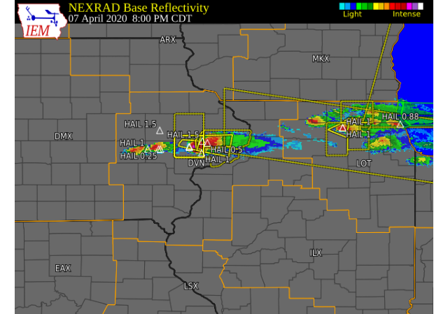
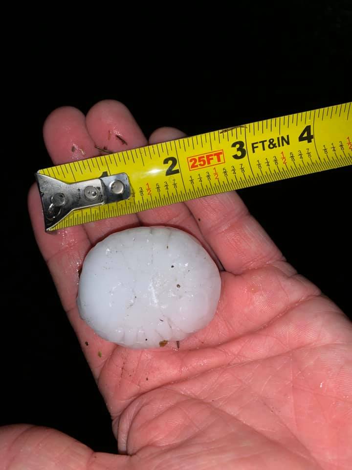
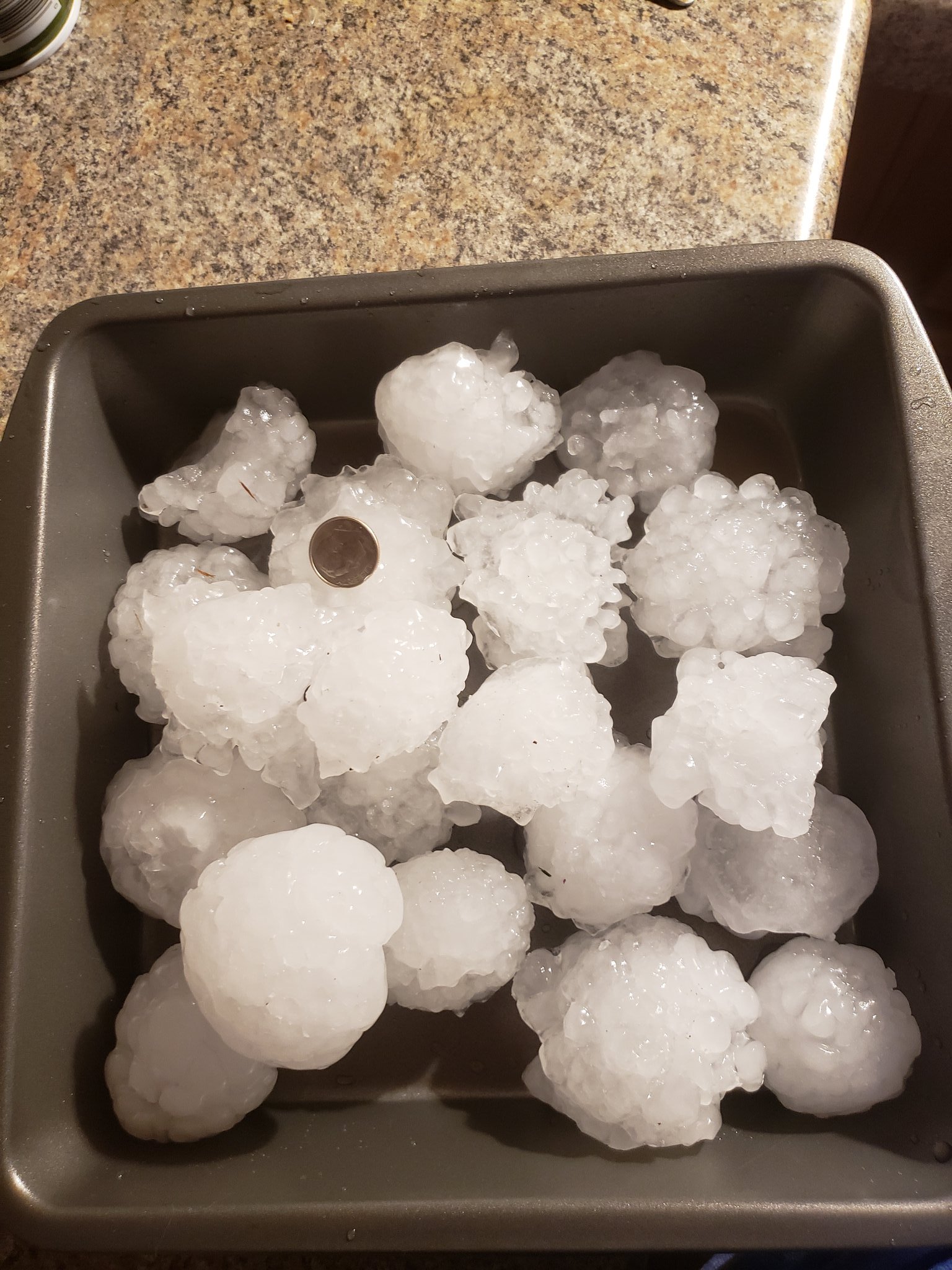
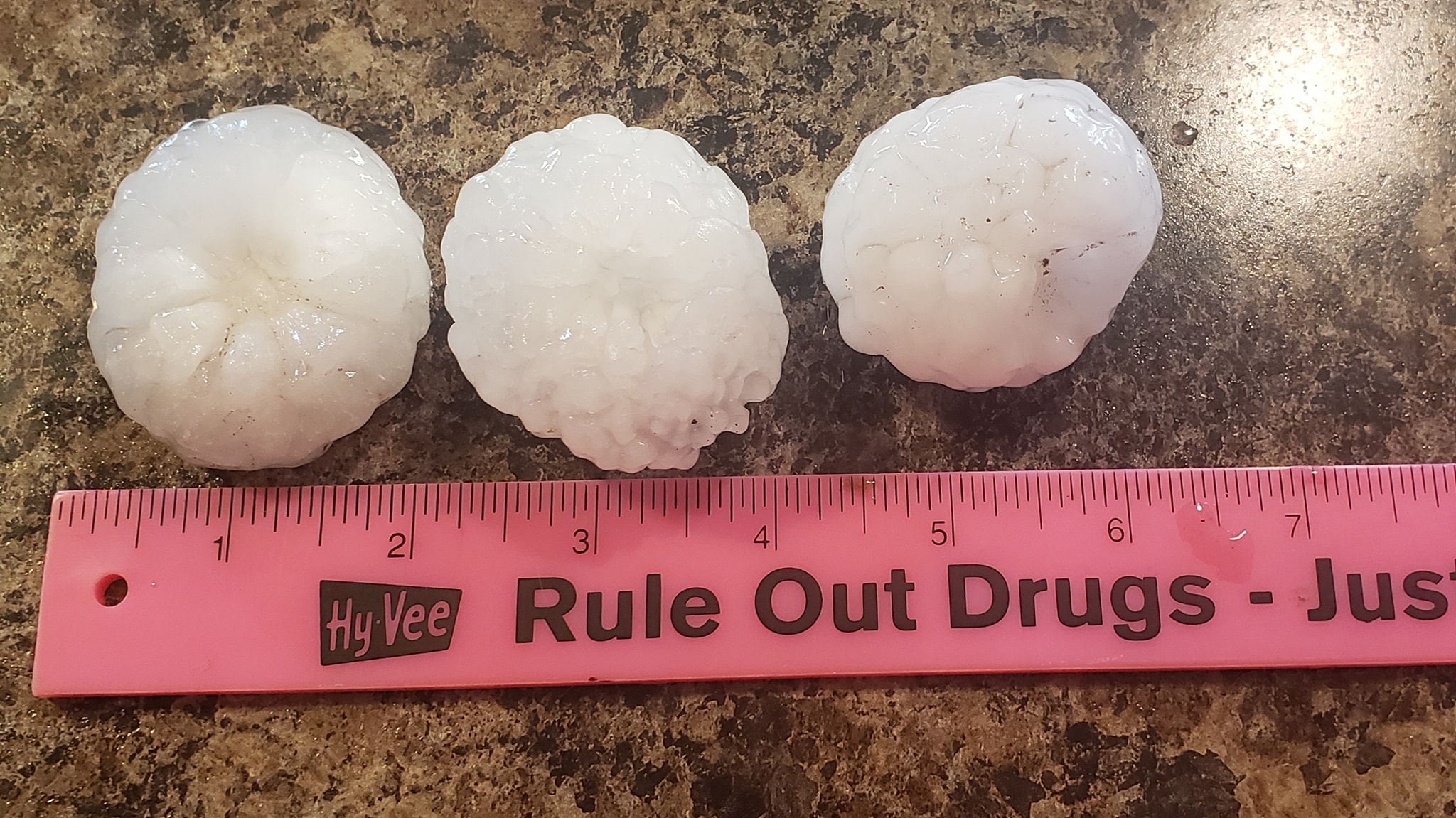
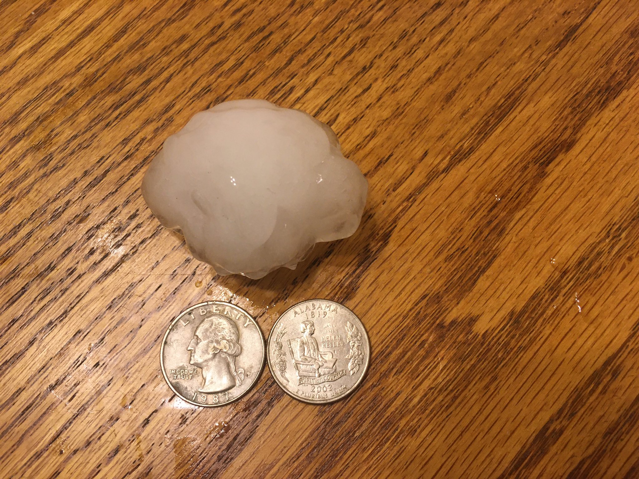
Severe thunderstorms developed along a cold front that dropped south across eastern Iowa and northwest Illinois Tuesday evening. Occasional lightning, heavy downpours, and very large hail were reported. The hardest hit areas were the northeast side of Cedar Rapids and the Iowa side of the Quad Cities where ping pong ball to baseball sized hail fell in a short amount of time. Golf ball hail fell in northern Stephenson county in IL near Orangeville. Widespread quarter sized hail was also reported during the evening in several other counties. |
 Near KGAN studio in Cedar Rapids, IA - photo by Nick Stewart |
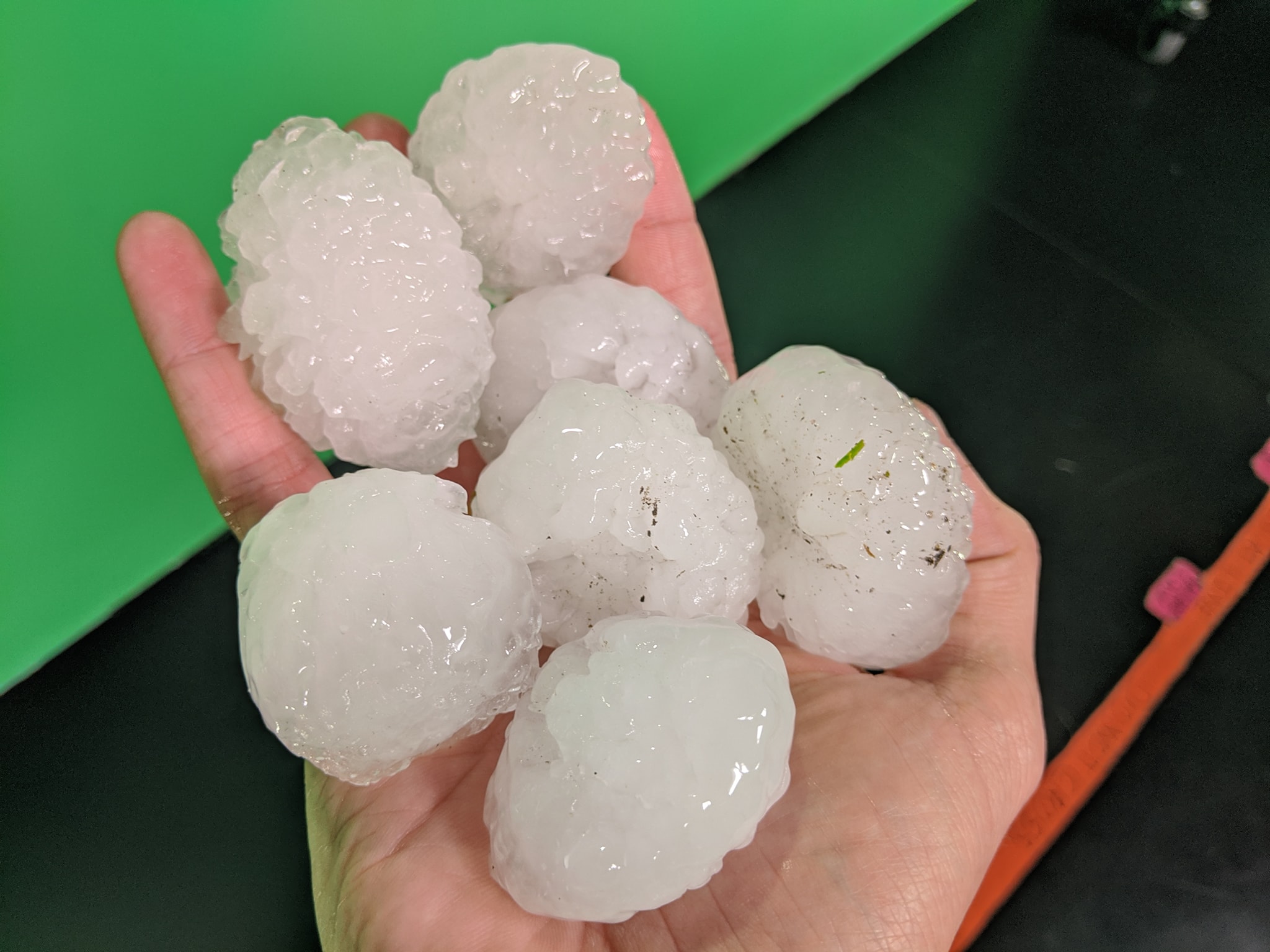
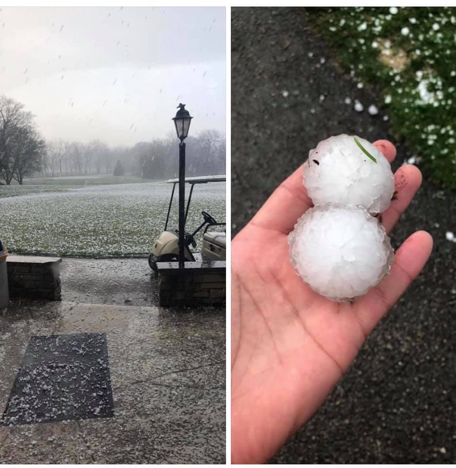
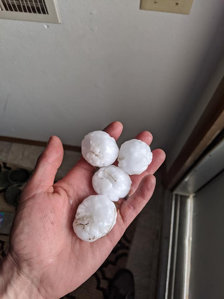
Hail Photos:
 |
 |
 |
 |
| St. Andrews Golf Course Cedar Rapids,IA Photo: Adam Colbeck |
Marion,IA Photo: Craig Smoldt |
Conesville,IA Photo: Auston Conaway |
Bettendorf, IA Photo: Kelli Emerson |
 |
 |
||
| NE Cedar Rapids,IA Photo: Heidi Popelka |
E Davenport,IA Photo: Zane Satre |
Storm Reports
| Interactive Storm Report Map | SPC Storm Reports |
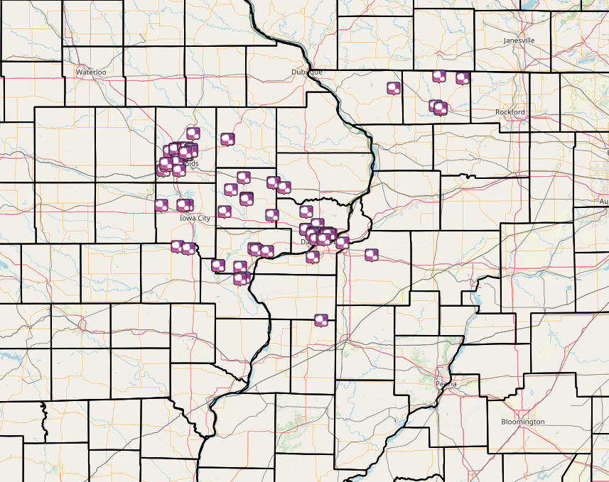 |
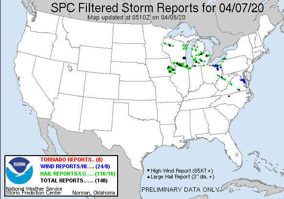 |
RELIMINARY LOCAL STORM REPORT...SUMMARY
NATIONAL WEATHER SERVICE QUAD CITIES IA IL
1159 PM CDT TUE APR 7 2020

..TIME...   ...EVENT...      ...CITY LOCATION...     ...LAT.LON...
..DATE...   ....MAG....      ..COUNTY LOCATION..ST.. ...SOURCE....
            ..REMARKS..

0552 PM     HAIL             HIAWATHA                42.05N 91.68W
04/07/2020  M0.25 INCH       LINN               IA   TRAINED SPOTTER


0608 PM     HAIL             4 NNE STOCKTON          42.40N 89.99W
04/07/2020  M0.70 INCH       JO DAVIESS         IL   TRAINED SPOTTER


0612 PM     HAIL             4 WSW WAUBEEK           42.14N 91.54W
04/07/2020  M0.70 INCH       LINN               IA   TRAINED SPOTTER

            HAIL WAS INCREASING IN SIZE DURING THE PHONE
            CALL.

0620 PM     HAIL             ORANGEVILLE             42.47N 89.64W
04/07/2020  M1.75 INCH       STEPHENSON         IL   PUBLIC

            RELAYED FROM BROADCAST MEDIA.

0622 PM     HAIL             3 E ROCK GROVE          42.46N 89.46W
04/07/2020  M0.25 INCH       STEPHENSON         IL   TRAINED SPOTTER


0629 PM     HAIL             1 ENE ANAMOSA           42.11N 91.27W
04/07/2020  M1.00 INCH       JONES              IA   TRAINED SPOTTER


0630 PM     HAIL             ANAMOSA                 42.11N 91.28W
04/07/2020  M0.88 INCH       JONES              IA   TRAINED SPOTTER


0640 PM     HAIL             2 NW MARION             42.05N 91.61W
04/07/2020  M2.00 INCH       LINN               IA   TRAINED SPOTTER


0640 PM     HAIL             2 W HIAWATHA            42.04N 91.72W
04/07/2020  M1.75 INCH       LINN               IA   TRAINED SPOTTER


0640 PM     HAIL             1 W HIAWATHA            42.04N 91.71W
04/07/2020  M1.00 INCH       LINN               IA   TRAINED SPOTTER


0641 PM     HAIL             2 ENE HIAWATHA          42.06N 91.65W
04/07/2020  E2.00 INCH       LINN               IA   TRAINED SPOTTER


0642 PM     HAIL             HIAWATHA                42.05N 91.68W
04/07/2020  E1.50 INCH       LINN               IA   TRAINED SPOTTER

            QUARTER TO GOLF BALL SIZE HAIL.

0644 PM     HAIL             3 ESE HIAWATHA          42.03N 91.64W
04/07/2020  M2.75 INCH       LINN               IA   BROADCAST MEDIA

            MEASURED AT KGAN.

0644 PM     HAIL             MARION                  42.04N 91.59W
04/07/2020  E1.00 INCH       LINN               IA   PUBLIC

            QUARTER SIZE HAIL COVERING THE ROUND.

0645 PM     HAIL             1 NNE CEDAR RAPIDS      41.98N 91.66W
04/07/2020  E2.50 INCH       LINN               IA   PUBLIC


0645 PM     HAIL             1 SW MARION             42.02N 91.60W
04/07/2020  M2.50 INCH       LINN               IA   PUBLIC


0645 PM     HAIL             3 ESE HIAWATHA          42.03N 91.64W
04/07/2020  M2.00 INCH       LINN               IA   BROADCAST MEDIA

            REPORT IS FROM KGAN STUDIOS. AT LEAST ONE
            BROKEN WIDSHIELD.

0645 PM     HAIL             2 WSW MARION            42.03N 91.62W
04/07/2020  M2.00 INCH       LINN               IA   PUBLIC


0645 PM     HAIL             HIAWATHA                42.05N 91.68W
04/07/2020  M1.75 INCH       LINN               IA   TRAINED SPOTTER

            CONSIDERABLE DAMAGE TO VEHICLES.

0646 PM     HAIL             2 W MARION              42.03N 91.63W
04/07/2020  E2.25 INCH       LINN               IA   PUBLIC

            REPORT FROM MPING: HEN EGG+ (2.25 IN.).

0646 PM     HAIL             2 WSW MARION            42.02N 91.63W
04/07/2020  M1.75 INCH       LINN               IA   TRAINED SPOTTER


0646 PM     HAIL             2 SE HIAWATHA           42.02N 91.66W
04/07/2020  M1.75 INCH       LINN               IA   TRAINED SPOTTER


0647 PM     HAIL             HIAWATHA                42.05N 91.68W
04/07/2020  M2.00 INCH       LINN               IA   PUBLIC

            CORRECTED THE TIME.

0648 PM     HAIL             2 ENE MARION            42.04N 91.56W
04/07/2020  E1.75 INCH       LINN               IA   TRAINED SPOTTER


0649 PM     HAIL             1 NW MARION             42.05N 91.61W
04/07/2020  E1.00 INCH       LINN               IA   TRAINED SPOTTER


0652 PM     HAIL             2 N CEDAR RAPIDS        41.99N 91.66W
04/07/2020  E1.75 INCH       LINN               IA   TRAINED SPOTTER


0654 PM     HAIL             MARION                  42.03N 91.60W
04/07/2020  E1.75 INCH       LINN               IA   PUBLIC


0654 PM     HAIL             1 N MARION              42.06N 91.59W
04/07/2020  E1.50 INCH       LINN               IA   TRAINED SPOTTER

            QUARTER TO PING PONG SIZE HIAL AT HIGHWAY 13
            AND 100.

0654 PM     HAIL             2 ENE MARION            42.05N 91.56W
04/07/2020  M1.50 INCH       LINN               IA   TRAINED SPOTTER


0655 PM     HAIL             CEDAR RAPIDS            41.98N 91.67W
04/07/2020  M1.00 INCH       LINN               IA   PUBLIC


0702 PM     HAIL             1 NE FAIRFAX            41.93N 91.77W
04/07/2020  M1.00 INCH       LINN               IA   TRAINED SPOTTER


0703 PM     HAIL             2 ENE MARION            42.04N 91.56W
04/07/2020  M1.75 INCH       LINN               IA   TRAINED SPOTTER


0704 PM     HAIL             3 NNE FAIRFAX           41.96N 91.75W
04/07/2020  M1.00 INCH       LINN               IA   TRAINED SPOTTER


0706 PM     HAIL             4 NE FAIRFAX            41.97N 91.75W
04/07/2020  U1.00 INCH       LINN               IA   PUBLIC


0710 PM     HAIL             3 SSE CEDAR RAPIDS      41.93N 91.65W
04/07/2020  E1.00 INCH       LINN               IA   TRAINED SPOTTER


0718 PM     HAIL             2 WNW FREEPORT          42.30N 89.67W
04/07/2020  M0.50 INCH       STEPHENSON         IL   TRAINED SPOTTER


0719 PM     HAIL             FREEPORT                42.29N 89.63W
04/07/2020  M1.00 INCH       STEPHENSON         IL   TRAINED SPOTTER


0719 PM     HAIL             FREEPORT                42.28N 89.63W
04/07/2020  M0.70 INCH       STEPHENSON         IL   TRAINED SPOTTER


0736 PM     HAIL             4 N BUCHANAN            41.82N 91.25W
04/07/2020  E1.00 INCH       CEDAR              IA   PUBLIC


0739 PM     HAIL             STANWOOD                41.89N 91.15W
04/07/2020  M1.00 INCH       CEDAR              IA   TRAINED SPOTTER


0742 PM     HAIL             LOWDEN                  41.86N 90.92W
04/07/2020  E1.75 INCH       CEDAR              IA   CO-OP OBSERVER


0748 PM     HAIL             TIPTON                  41.77N 91.13W
04/07/2020  M1.00 INCH       CEDAR              IA   PUBLIC


0749 PM     HAIL             MARION                  42.03N 91.60W
04/07/2020  M1.50 INCH       LINN               IA   PUBLIC


0753 PM     HAIL             TIPTON                  41.77N 91.13W
04/07/2020  E1.00 INCH       CEDAR              IA   TRAINED SPOTTER


0753 PM     HAIL             TIPTON                  41.77N 91.13W
04/07/2020  M0.70 INCH       CEDAR              IA   PUBLIC


0754 PM     HAIL             OXFORD                  41.73N 91.79W
04/07/2020  E1.00 INCH       JOHNSON            IA   LAW ENFORCEMENT

            SHERIFF DEPUTY ESTIMATED QUARTER.

0755 PM     HAIL             1 S TIPTON              41.76N 91.13W
04/07/2020  M1.50 INCH       CEDAR              IA   PUBLIC


0759 PM     HAIL             LOWDEN                  41.86N 90.92W
04/07/2020  M1.50 INCH       CEDAR              IA   CO-OP OBSERVER

            HAIL WAS MAINLY DIME TO QUARTER WITH LARGEST
            HAILSTONE BEING 1.5 INCHES.

0801 PM     HAIL             1 SE NORTH LIBERTY      41.73N 91.59W
04/07/2020  E0.25 INCH       JOHNSON            IA   TRAINED SPOTTER


0805 PM     HAIL             WHEATLAND               41.83N 90.84W
04/07/2020  E0.50 INCH       CLINTON            IA   PUBLIC

            REPORT FROM MPING: HALF-INCH (0.50 IN.).

0810 PM     HAIL             1 SSW NORTH LIBERTY     41.73N 91.62W
04/07/2020  M0.25 INCH       JOHNSON            IA   TRAINED SPOTTER


0812 PM     HAIL             SUNBURY                 41.67N 90.93W
04/07/2020  E1.00 INCH       CEDAR              IA   TRAINED SPOTTER


0819 PM     HAIL             DONAHUE                 41.69N 90.67W
04/07/2020  M0.75 INCH       SCOTT              IA   PUBLIC


0829 PM     HAIL             4 WNW DAVENPORT         41.59N 90.67W
04/07/2020  M1.75 INCH       SCOTT              IA   TRAINED SPOTTER

            CORRECTS PREVIOUS TIME OF THE REPORT FROM
            831 TO 829. HAIL REPORT FROM 4 WNW
            DAVENPORT. SPOTTER REPORTED GOLF BALL SIZE
            HAIL AT WEST KIMBERLY AND I-280.

0831 PM     HAIL             4 NW DAVENPORT          41.59N 90.67W
04/07/2020  E2.00 INCH       SCOTT              IA   TRAINED SPOTTER


0835 PM     HAIL             2 NW SPRINGDALE         41.69N 91.30W
04/07/2020  E0.50 INCH       CEDAR              IA   PUBLIC


0837 PM     HAIL             DAVENPORT MUNICIPALITY  41.62N 90.58W
04/07/2020  E1.00 INCH       SCOTT              IA   NWS EMPLOYEE


0839 PM     HAIL             1 N DAVENPORT           41.57N 90.61W
04/07/2020  M1.00 INCH       SCOTT              IA   TRAINED SPOTTER


0840 PM     HAIL             2 ENE DAVENPORT         41.57N 90.58W
04/07/2020  E2.00 INCH       SCOTT              IA   TRAINED SPOTTER


0840 PM     HAIL             1 NNW DAVENPORT         41.57N 90.61W
04/07/2020  E1.25 INCH       SCOTT              IA   TRAINED SPOTTER


0840 PM     HAIL             2 W BETTENDORF          41.57N 90.51W
04/07/2020  M1.00 INCH       SCOTT              IA   PUBLIC

            REPORT FROM MPING: QUARTER (1.00 IN.).

0841 PM     HAIL             3 E DAVENPORT           41.55N 90.55W
04/07/2020  E2.00 INCH       SCOTT              IA   NWS EMPLOYEE

            1.50 TO 2.00 INCH HAIL.

0841 PM     HAIL             1 NE DAVENPORT          41.57N 90.59W
04/07/2020  M1.75 INCH       SCOTT              IA   NWS EMPLOYEE


0842 PM     HAIL             2 W BETTENDORF          41.57N 90.51W
04/07/2020  M1.75 INCH       SCOTT              IA   NWS EMPLOYEE


0844 PM     HAIL             1 NW DAVENPORT          41.56N 90.62W
04/07/2020  M1.25 INCH       SCOTT              IA   TRAINED SPOTTER


0845 PM     HAIL             2 W BETTENDORF          41.55N 90.52W
04/07/2020  U2.00 INCH       SCOTT              IA   PUBLIC


0845 PM     HAIL             2 SSE DAVENPORT         41.53N 90.59W
04/07/2020  E1.50 INCH       SCOTT              IA   TRAINED SPOTTER


0845 PM     HAIL             BETTENDORF              41.56N 90.48W
04/07/2020  M1.00 INCH       SCOTT              IA   TRAINED SPOTTER


0846 PM     HAIL             3 ESE DAVENPORT         41.54N 90.54W
04/07/2020  M1.50 INCH       SCOTT              IA   NWS EMPLOYEE


0849 PM     HAIL             2 WSW BETTENDORF        41.56N 90.51W
04/07/2020  E1.75 INCH       SCOTT              IA   TRAINED SPOTTER

            A FEW STONES WERE GOLF BALL SIZE.

0852 PM     HAIL             1 W BETTENDORF          41.56N 90.49W
04/07/2020  E1.25 INCH       SCOTT              IA   TRAINED SPOTTER

            MOSTLY PEA SIZED HIAL WITH A FEW SILVER
            DOLLAR SIZED HAILSTONES.

0855 PM     HAIL             3 W RIVERDALE           41.53N 90.53W
04/07/2020  M1.75 INCH       SCOTT              IA   TRAINED SPOTTER


0900 PM     HAIL             1 N CARBON CLIFF        41.51N 90.39W
04/07/2020  M1.50 INCH       ROCK ISLAND        IL   TRAINED SPOTTER


0909 PM     HAIL             2 E KALONA              41.49N 91.66W
04/07/2020  M0.88 INCH       WASHINGTON         IA   TRAINED SPOTTER


0912 PM     HAIL             RIVERSIDE               41.48N 91.58W
04/07/2020  M1.00 INCH       WASHINGTON         IA   TRAINED SPOTTER


0913 PM     HAIL             4 N MUSCATINE           41.48N 91.07W
04/07/2020  M0.88 INCH       MUSCATINE          IA   TRAINED SPOTTER


0918 PM     HAIL             3 S SWEETLAND CENTER    41.46N 90.97W
04/07/2020  E1.25 INCH       MUSCATINE          IA   PUBLIC

            REPORT FROM MPING: HALF DOLLAR (1.25 IN.).

0918 PM     HAIL             2 N MUSCATINE           41.47N 91.05W
04/07/2020  E1.00 INCH       MUSCATINE          IA   CO-OP OBSERVER


0920 PM     HAIL             1 SSW GENESEO           41.44N 90.16W
04/07/2020  E0.70 INCH       HENRY              IL   TRAINED SPOTTER

            PEA TO DIME SIZE HAIL.

0937 PM     HAIL             CONESVILLE              41.38N 91.35W
04/07/2020  E2.00 INCH       MUSCATINE          IA   FIRE DEPT/RESCUE

            REPORT FROM FIRE DEPARTMENT CHIEF, SOME HAIL
            STONES OF 2.25 INCHES.

0939 PM     HAIL             CONESVILLE              41.38N 91.35W
04/07/2020  M1.50 INCH       MUSCATINE          IA   FIRE DEPT/RESCUE

            REPORTED BY CONESVILLE VOLUNTEER
            FIREFIGHTER.

0940 PM     HAIL             CONESVILLE              41.38N 91.35W
04/07/2020  E1.75 INCH       MUSCATINE          IA   PUBLIC


0945 PM     HAIL             3 WNW OAK GROVE         41.43N 90.62W
04/07/2020  E0.50 INCH       ROCK ISLAND        IL   TRAINED SPOTTER

            PEA TO DIMES.

0947 PM     HAIL             2 W MUSCATINE MUNICIPAL 41.37N 91.18W
04/07/2020  M1.75 INCH       MUSCATINE          IA   PUBLIC

            REPORT FROM SOCIAL MEDIA WITH PICTURES.

0951 PM     HAIL             2 ESE SAND SPRINGS      41.31N 91.15W
04/07/2020  M1.00 INCH       LOUISA             IA   TRAINED SPOTTER

            NICKEL TO QUARTERS.

0953 PM     HAIL             1 SSE SAND SPRINGS      41.30N 91.18W
04/07/2020  M1.50 INCH       LOUISA             IA   TRAINED SPOTTER


1045 PM     HAIL             1 E ALEXIS              41.06N 90.55W
04/07/2020  M1.25 INCH       WARREN             IL   TRAINED SPOTTER

            HAIL WAS 3/4 TO 1.5 INCHES WITH MOST STONES
            AT QUARTER SIZED.
Environment
SPC Event Summary - April 7th, 2020
 |
 |
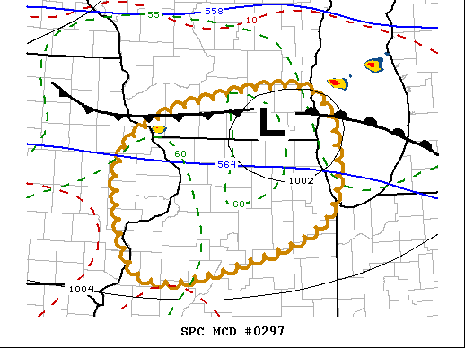 |
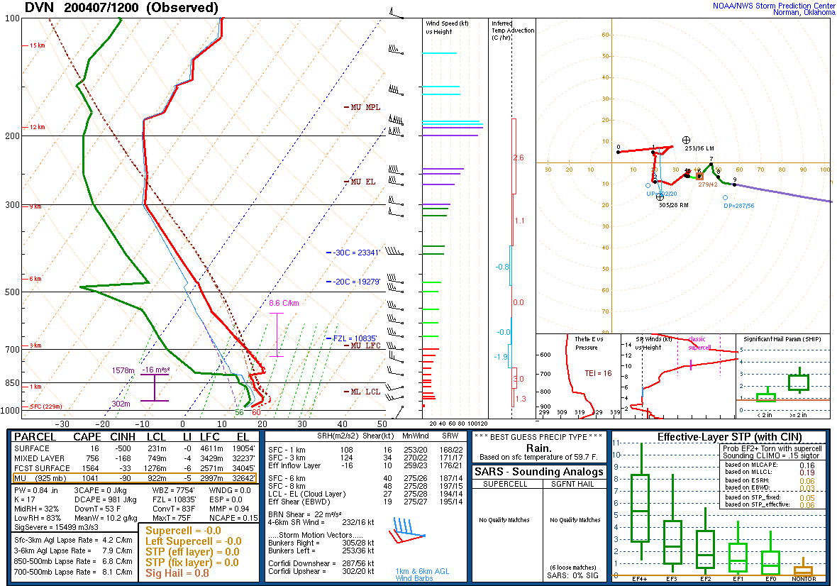
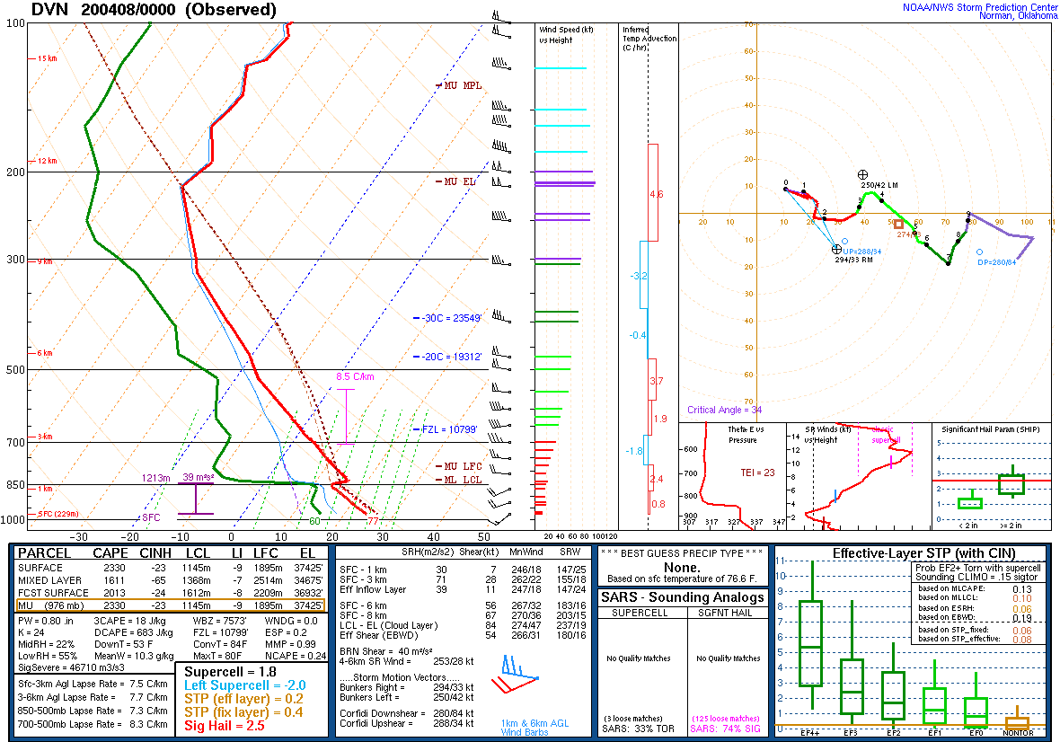
| Figure 1: DVN 12z 04/07 Sounding | Figure 2: DVN 00z 04/08 Sounding | Figure 3: SPC MCD #297 |
 |
 |
.gif) |
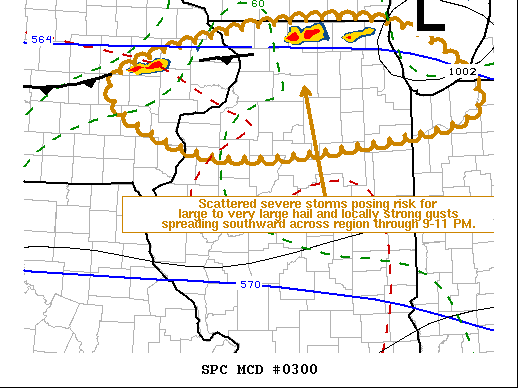
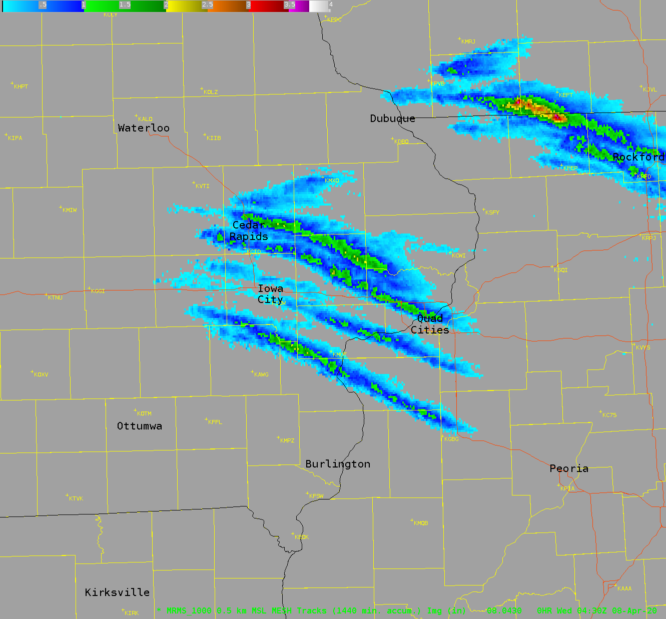
| Figure 4: SPC MCD #300 | Figure 5: MRMS MESH tracks | Figure 6: MRMS MESH loop |
 |
 |
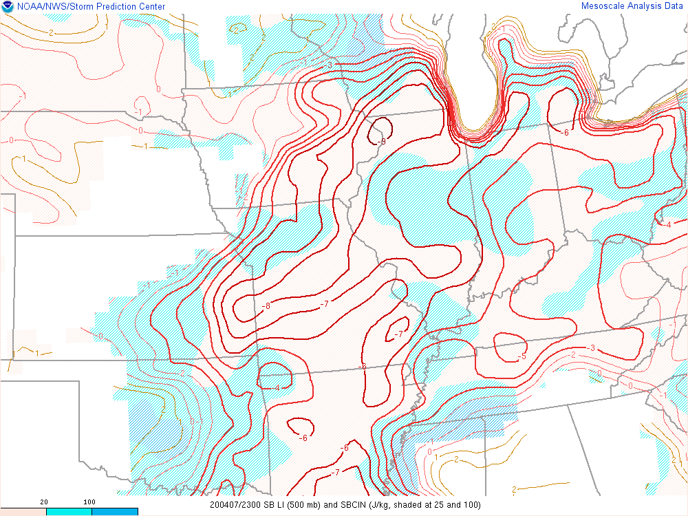 |
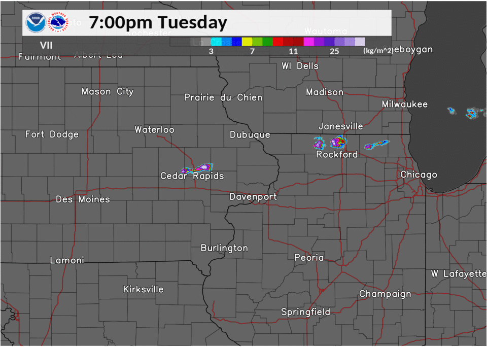
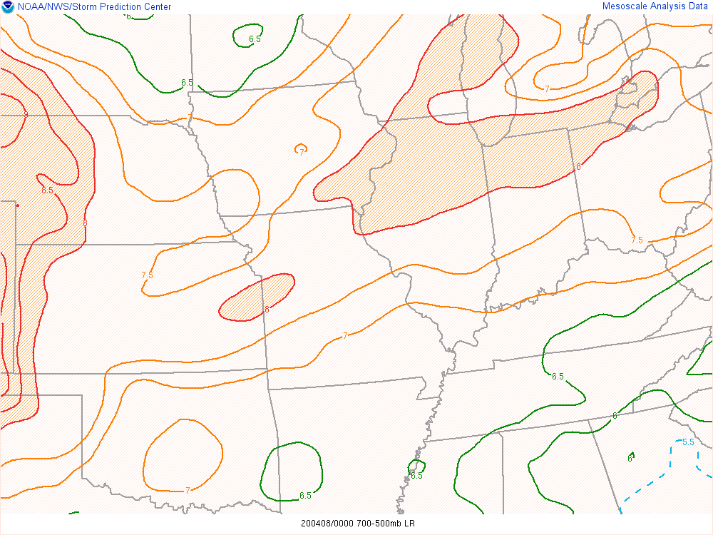
| Figure 7: MRMS VII loop | Figure 8: 00z 04/08 700-500 mb lapse rate | Figure 9: 23z 04/07 Lifted Index / SBCIN |
 |
 |
|
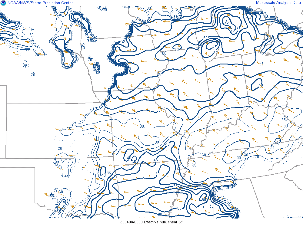
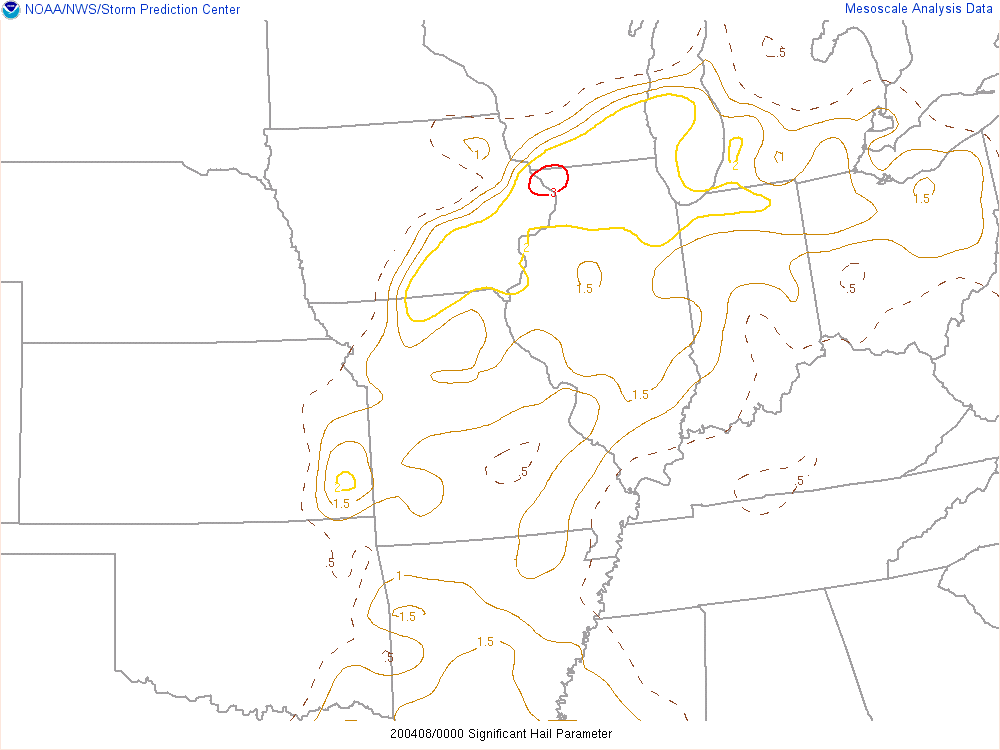
| Figure 10: 00z 04/08 Effective Bulk Shear | Figure 11: 00z 04/08 Sig Hail Parameter |
 |
Media use of NWS Web News Stories is encouraged! Please acknowledge the NWS as the source of any news information accessed from this site. |
|