Scattered severe thunderstorms capable of damaging wind gusts and some hail are expected this afternoon and evening from the Upper Ohio River Valley into the Northeast, and from the Appalachians into the Mid-Atlantic States. Excessive rainfall from heavy thunderstorms may produce areas of flash flooding from southern New Mexico into the western and northern Gulf Coast into Wednesday. Read More >
Overview
|
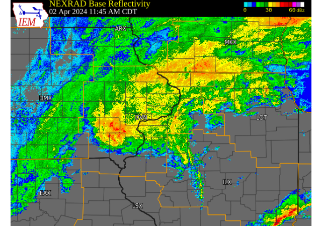
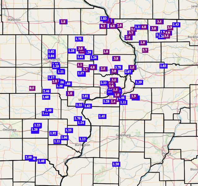
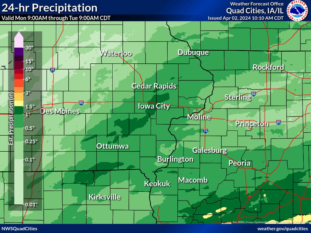
A strong system brought a mix of heavy rain, snow, and strong winds to all of eastern Iowa, northwest Illinois and northeast Missouri on the days of April 1- 3, 2024. Precipitation began as all rain during the morning of April 2nd, but quickly changed to a moderate to heavy snow by early afternoon as colder air moved into the area. Snow amounts between 2-4 inches were observed across portions of eastern Iowa, with widespread rainfall amounts of 1-3 inches. Areas of light to moderate snow and rain continued into April 3rd, with snowfall totals around 3-5 inches mainly along and north of Highway 30 in eastern Iowa and northwest Illinois. A snowfall amount of 6.8 inches was observed in eastern Dubuque county. In addition, strong northwest winds accompanied the system on April 3rd. Maximum wind gusts around 35-45 MPH were observed. NWS Official Totals |
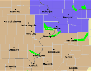 Watch, Warning, Advisory Map - 8am April 3rd, 2024 |
Snow/Ice
| Snowfall Reports | Local Snowfall Map | Regional Snowfall | |
 |
 |
.png) |
|
SNOW REPORTS LISTED BY AMOUNT

 INCHES  LOCATION                 ST  COUNTY           TIME
 ------  -----------------------  --  --------------   -------
  6.8    2 E KING                 IA  DUBUQUE          0735 AM
  6.5    DUBUQUE REGIONAL ARPT    IA  DUBUQUE          0700 PM
  4.0    3 SW WINNESHIEK          IL  STEPHENSON       0834 AM
  4.0    FREEPORT                 IL  STEPHENSON       0745 AM
  4.0    3 N STOCKTON             IL  JO DAVIESS       0735 AM
  4.0    LOWDEN                   IA  CEDAR            0700 AM
  3.9    DAKOTA                   IL  STEPHENSON       0805 AM
  3.8    2 WNW CHARLOTTE          IA  CLINTON          0700 AM
  3.7    ELIZABETH                IL  JO DAVIESS       0630 AM
  3.5    2 N FREEPORT ALBERTUS    IL  STEPHENSON       1231 PM
  3.5    PARK VIEW                IA  SCOTT            0700 AM
  3.5    3 NNE MC CONNELL         IL  STEPHENSON       0700 AM
  3.0    1 SSE DEWITT             IA  CLINTON          0800 AM
  3.0    3 W CENTER JUNCTION      IA  JONES            0800 AM
  3.0    LENA                     IL  STEPHENSON       0700 AM
  2.9    1 NW ELDRIDGE            IA  SCOTT            0700 AM
  2.8    1 S CORALVILLE           IA  JOHNSON          0800 AM
  2.7    4 S CLARENCE             IA  CEDAR            0700 AM
  2.5    1 SE DUBUQUE             IA  DUBUQUE          0730 AM
  2.5    2 NE CALAMUS             IA  CLINTON          0700 AM
  2.5    2 SE EAST DUBUQUE        IL  JO DAVIESS       0700 AM
  2.5    HANOVER                  IL  JO DAVIESS       0700 AM
  2.0    GALENA                   IL  JO DAVIESS       0917 PM
  1.9    6 SSE ELMOVILLE          IL  CARROLL          0730 AM
  1.9    2 NW GENESEO             IL  HENRY            0500 AM
  1.8    1 SSE MANCHESTER         IA  DELAWARE         0700 AM
  1.6    DAVENPORT AIRPORT        IA  SCOTT            0142 PM
  1.6    2 WNW BETTENDORF         IA  SCOTT            0700 AM
  1.5    2 W BETTENDORF           IA  SCOTT            0730 AM
  1.5    2 NE CLINTON             IA  CLINTON          0600 AM
  1.4    QUAD CITY AIRPORT        IL  ROCK ISLAND      0142 PM
  1.0    1 NNE MOLINE             IL  ROCK ISLAND      0800 AM
  1.0    2 NNW NICHOLS            IA  MUSCATINE        0700 AM
Wind Reports
 |
Public Information Statement
National Weather Service Quad Cities IA IL
711 PM CDT Wed Apr 3 2024

...Highest Wind Reports Past 24 Hours...

Observations are collected from a variety of sources with varying
equipment and exposures. We thank all volunteer weather observers
for their dedication. Not all data listed are considered official.

Location                     Speed     Time/Date       Provider
Lowden                       55 MPH    0543 PM 04/03   MESOWEST
Cedar Rapids Arpt            54 MPH    0615 PM 04/03   ASOS
Independence Arpt            48 MPH    1035 AM 04/03   AWOS
Anamosa                      46 MPH    1140 AM 04/03   MESOWEST
Us-30 At Us-218              46 MPH    0445 PM 04/03   MESOWEST
Quasqueton                   45 MPH    1230 PM 04/03   CWOP
Iowa City Arpt               45 MPH    1031 AM 04/03   ASOS
Stanley                      44 MPH    0115 PM 04/03   CWOP
Washington Arpt              44 MPH    1035 AM 04/03   AWOS
Fairfield Arpt               44 MPH    1115 AM 04/03   AWOS
Sigourney                    44 MPH    0355 PM 04/03   MESOWEST
Us-30 Mt Vernon              44 MPH    1225 PM 04/03   MESOWEST
Olin                         43 MPH    0540 PM 04/03   CWOP
Dubuque Arpt                 43 MPH    0353 PM 04/03   ASOS
Urbana                       43 MPH    1040 AM 04/03   MESOWEST
Victor                       43 MPH    0240 PM 04/03   MESOWEST
Independence                 42 MPH    1200 PM 04/03   CWOP
Marion                       41 MPH    1045 AM 04/03   CWOP
Stockton                     41 MPH    1245 PM 04/03   CWOP
Fairbank                     41 MPH    0301 PM 04/03   CWOP
Davenport Arpt               40 MPH    1032 AM 04/03   ASOS
Muscatine Arpt               40 MPH    1135 AM 04/03   AWOS
Vinton Arpt                  40 MPH    0415 PM 04/03   AWOS
Cedar Rapids I-380           40 MPH    1040 AM 04/03   MESOWEST
Iowa City Us 218             40 MPH    1010 AM 04/03   MESOWEST
Fairfax                      39 MPH    0955 AM 04/03   DAVIS
Marengo                      39 MPH    0545 PM 04/03   DAVIS
Quad City Intl Arpt          39 MPH    0149 PM 04/03   ASOS
Urbana                       38 MPH    1100 AM 04/03   CWOP
New London                   38 MPH    0200 PM 04/03   CWOP
Rowley                       38 MPH    0315 PM 04/03   DAVIS
Vinton                       38 MPH    1035 AM 04/03   DAVIS
Dubuque                      38 MPH    0207 PM 04/03   CWOP
Monmouth                     38 MPH    1235 PM 04/03   CWOP
Burlington Arpt              38 MPH    1131 PM 04/02   ASOS
Mount Pleasant Arpt          38 MPH    0835 AM 04/03   AWOS
Davenport                    38 MPH    0505 PM 04/03   MESOWEST
Clinton Arpt                 37 MPH    0321 PM 04/03   AWOS
Macomb Arpt                  37 MPH    0335 PM 04/03   AWOS
I-80 At I-380                37 MPH    0840 AM 04/03   MESOWEST
Lamont                       36 MPH    1155 AM 04/03   DAVIS
Vinton                       36 MPH    0425 PM 04/03   DAVIS
Winthrop                     36 MPH    0915 AM 04/03   CWOP
Riverside                    36 MPH    0700 AM 04/03   CWOP
Eldridge                     36 MPH    0127 PM 04/03   CWOP
Freeport Arpt                36 MPH    1215 PM 04/03   AWOS
Stockton 3 Nne               36 MPH    0735 AM 04/03   COOP
Mechanicsville               35 MPH    1140 AM 04/03   DAVIS
Macomb                       35 MPH    1158 AM 04/03   CWOP
Cantril                      35 MPH    1255 PM 04/03   MESOWEST
De Witt                      35 MPH    0555 PM 04/03   MESOWEST
Tipton                       35 MPH    1240 PM 04/03   MESOWEST
Storm Reports
📠Storm Reports ðŸ“
Storm Reports Map - Courtesy IEM
 |
PRELIMINARY LOCAL STORM REPORT...SUMMARY
NATIONAL WEATHER SERVICE QUAD CITIES IA IL
829 PM CDT WED APR 3 2024

..TIME...   ...EVENT...      ...CITY LOCATION...     ...LAT.LON...
..DATE...   ....MAG....      ..COUNTY LOCATION..ST.. ...SOURCE....
            ..REMARKS..

0735 AM     SNOW             2 E KING                42.41N 90.56W
04/03/2024  M6.8 INCH        DUBUQUE            IA   COCORAHS

            COCORAHS STATION IA-DB-31 BELLEVUE 12.2 NW.

0700 PM     SNOW             DUBUQUE REGIONAL ARPT   42.41N 90.73W
04/03/2024  M6.5 INCH        DUBUQUE            IA   OFFICIAL NWS OBS

            STORM TOTAL, 0.3 TENTHS FELL AFTER 1 PM.
            SNOW QUICKLY MELTING.

0700 AM     SNOW             LOWDEN                  41.86N 90.92W
04/03/2024  M4.0 INCH        CEDAR              IA   CO-OP OBSERVER

            STORM TOTAL FROM 1ST EVENT.

0735 AM     SNOW             3 N STOCKTON            42.40N 90.00W
04/03/2024  M4.0 INCH        JO DAVIESS         IL   CO-OP OBSERVER

            CO-OP OBSERVER STATION STOI2 STOCKTON 3 NNE.

0745 AM     SNOW             FREEPORT                42.29N 89.63W
04/03/2024  M4.0 INCH        STEPHENSON         IL   TRAINED SPOTTER

            STORM TOTAL AS OF 745A.

0834 AM     SNOW             3 SW WINNESHIEK         42.32N 89.57W
04/03/2024  M4.0 INCH        STEPHENSON         IL   TRAINED SPOTTER


0805 AM     SNOW             DAKOTA                  42.39N 89.53W
04/03/2024  M3.9 INCH        STEPHENSON         IL   PUBLIC

            RELAYED FROM BROADCAST MEDIA.

0700 AM     SNOW             2 WNW CHARLOTTE         41.98N 90.50W
04/03/2024  M3.8 INCH        CLINTON            IA   COCORAHS

            COCORAHS STATION IA-CN-17 CHARLOTTE 1.9 WNW.

0630 AM     SNOW             ELIZABETH               42.32N 90.23W
04/03/2024  M3.7 INCH        JO DAVIESS         IL   CO-OP OBSERVER

            CO-OP OBSERVER STATION EZBI2 ELIZABETH.

0700 AM     SNOW             3 NNE MC CONNELL        42.47N 89.72W
04/03/2024  M3.5 INCH        STEPHENSON         IL   COCORAHS

            COCORAHS STATION IL-SP-8 WINSLOW 4.3 ESE.

0700 AM     SNOW             PARK VIEW               41.69N 90.54W
04/03/2024  M3.5 INCH        SCOTT              IA   COCORAHS

            COCORAHS STATION IA-ST-3 PARK VIEW 0.2 WSW.

1231 PM     SNOW             2 N FREEPORT ALBERTUS   42.28N 89.59W
04/03/2024  M3.5 INCH        STEPHENSON         IL   PUBLIC

            STORM TOTAL.

0700 AM     SNOW             LENA                    42.38N 89.82W
04/03/2024  M3.0 INCH        STEPHENSON         IL   COCORAHS

            COCORAHS STATION IL-SP-31 LENA 0.3 SSE.

0800 AM     SNOW             3 W CENTER JUNCTION     42.11N 91.14W
04/03/2024  M3.0 INCH        JONES              IA   COCORAHS

            COCORAHS STATION IA-JN-10 CENTER JUNCTION
            2.6 W.

0800 AM     SNOW             1 SSE DEWITT            41.81N 90.54W
04/03/2024  M3.0 INCH        CLINTON            IA   CO-OP OBSERVER

            CO-OP OBSERVER STATION DWTI4 DE WITT.

0700 AM     SNOW             1 NW ELDRIDGE           41.64N 90.59W
04/03/2024  M2.9 INCH        SCOTT              IA   COCORAHS

            COCORAHS STATION IA-ST-30 ELDRIDGE 0.7 SSW.

0800 AM     SNOW             1 S CORALVILLE          41.67N 91.60W
04/03/2024  M2.8 INCH        JOHNSON            IA   COCORAHS

            COCORAHS STATION IA-JH-20 CORALVILLE 1.4 S.

0700 AM     SNOW             4 S CLARENCE            41.83N 91.05W
04/03/2024  M2.7 INCH        CEDAR              IA   COCORAHS

            COCORAHS STATION IA-CD-10 CLARENCE 3.9 S.

0700 AM     SNOW             HANOVER                 42.26N 90.28W
04/03/2024  M2.5 INCH        JO DAVIESS         IL   COCORAHS

            COCORAHS STATION IL-JD-6 HANOVER 0.2 NW.

0700 AM     SNOW             2 SE EAST DUBUQUE       42.48N 90.61W
04/03/2024  M2.5 INCH        JO DAVIESS         IL   COCORAHS

            COCORAHS STATION IL-JD-11 EAST DUBUQUE 1.7
            SE.

0700 AM     SNOW             2 NE CALAMUS            41.84N 90.73W
04/03/2024  M2.5 INCH        CLINTON            IA   COCORAHS

            COCORAHS STATION IA-CN-2 CALAMUS 2.0 NE.

0730 AM     SNOW             1 SE DUBUQUE            42.49N 90.67W
04/03/2024  M2.5 INCH        DUBUQUE            IA   COCORAHS

            COCORAHS STATION IA-DB-23 DUBUQUE 1.0 SE.

0700 AM     RAIN             1 NW ELDRIDGE           41.64N 90.59W
04/03/2024  M2.49 INCH       SCOTT              IA   COCORAHS

            COCORAHS STATION IA-ST-30 ELDRIDGE 0.7 SSW.

0500 AM     RAIN             3 NNE BOLTON            42.29N 89.72W
04/03/2024  M2.39 INCH       STEPHENSON         IL   COCORAHS

            COCORAHS STATION IL-SP-28 FREEPORT 4.3 W.

0700 AM     RAIN             3 NNE MC CONNELL        42.47N 89.72W
04/03/2024  M2.21 INCH       STEPHENSON         IL   COCORAHS

            COCORAHS STATION IL-SP-8 WINSLOW 4.3 ESE.

0700 AM     RAIN             HANOVER                 42.26N 90.28W
04/03/2024  M2.21 INCH       JO DAVIESS         IL   COCORAHS

            COCORAHS STATION IL-JD-6 HANOVER 0.2 NW.

0700 AM     RAIN             1 SE DAVENPORT          41.54N 90.59W
04/03/2024  M2.08 INCH       SCOTT              IA   COCORAHS

            COCORAHS STATION IA-ST-37 DAVENPORT 0.9 WNW.

0700 AM     RAIN             2 WNW BETTENDORF        41.57N 90.51W
04/03/2024  M2.06 INCH       SCOTT              IA   COCORAHS

            COCORAHS STATION IA-ST-65 DAVENPORT 4.3 NE.

0700 AM     RAIN             4 S CLARENCE            41.83N 91.05W
04/03/2024  M2.01 INCH       CEDAR              IA   COCORAHS

            COCORAHS STATION IA-CD-10 CLARENCE 3.9 S.

0700 AM     RAIN             4 NNE MUSCATINE         41.47N 91.05W
04/03/2024  M2.01 INCH       MUSCATINE          IA   CO-OP OBSERVER

            CO-OP OBSERVER STATION MSTI4 2 N MUSCATINE.

0917 PM     SNOW             GALENA                  42.42N 90.44W
04/02/2024  M2.0 INCH        JO DAVIESS         IL   TRAINED SPOTTER


0730 AM     RAIN             2 W BETTENDORF          41.56N 90.51W
04/03/2024  M2.00 INCH       SCOTT              IA   COCORAHS

            COCORAHS STATION IA-ST-48 BETTENDORF 1.6 W.

0600 AM     RAIN             1 NW DUBUQUE REGIONAL A 42.41N 90.73W
04/03/2024  M1.99 INCH       DUBUQUE            IA   CO-OP OBSERVER

            CO-OP OBSERVER STATION DUBI4 DUBUQUE 7 SSW.

0700 AM     RAIN             2 WNW CHARLOTTE         41.98N 90.50W
04/03/2024  M1.95 INCH       CLINTON            IA   COCORAHS

            COCORAHS STATION IA-CN-17 CHARLOTTE 1.9 WNW.

0500 AM     SNOW             2 NW GENESEO            41.47N 90.18W
04/03/2024  M1.9 INCH        HENRY              IL   COCORAHS

            COCORAHS STATION IL-HY-8 GENESEO 2.0 NW.

0730 AM     SNOW             6 SSE ELMOVILLE         42.19N 90.02W
04/03/2024  M1.9 INCH        CARROLL            IL   COCORAHS

            COCORAHS STATION IL-CR-12 MOUNT CARROLL 6.8
            NNW.

0700 AM     RAIN             2 NNW NICHOLS           41.51N 91.33W
04/03/2024  M1.85 INCH       MUSCATINE          IA   COCORAHS

            COCORAHS STATION IA-MC-21 NICHOLS 2.5 NNW.

1231 PM     RAIN             1 W DUBUQUE             42.51N 90.72W
04/03/2024  M1.83 INCH       DUBUQUE            IA   TRAINED SPOTTER

            TOTAL LIQUID FROM RAIN AND SNOW.

0700 AM     SNOW             1 SSE MANCHESTER        42.47N 91.45W
04/03/2024  M1.8 INCH        DELAWARE           IA   CO-OP OBSERVER

            CO-OP OBSERVER STATION MHRI4 MANCHESTER.

0600 AM     RAIN             1 NNW MONTICELLO MUNICI 42.24N 91.17W
04/03/2024  M1.75 INCH       JONES              IA   CO-OP OBSERVER

            CO-OP OBSERVER STATION MCLI4 MONTICELLO.

0800 AM     RAIN             3 W CENTER JUNCTION     42.11N 91.14W
04/03/2024  M1.75 INCH       JONES              IA   COCORAHS

            COCORAHS STATION IA-JN-10 CENTER JUNCTION
            2.6 W.

0700 AM     RAIN             LENA                    42.38N 89.82W
04/03/2024  M1.71 INCH       STEPHENSON         IL   COCORAHS

            COCORAHS STATION IL-SP-31 LENA 0.3 SSE.

0700 AM     RAIN             WAPELLO                 41.17N 91.19W
04/03/2024  M1.70 INCH       LOUISA             IA   COCORAHS

            COCORAHS STATION IA-LS-3 WAPELLO 0.2 S.

0700 AM     RAIN             1 N RIVERDALE           41.54N 90.47W
04/03/2024  M1.69 INCH       SCOTT              IA   COCORAHS

            COCORAHS STATION IA-ST-42 RIVERDALE 0.5 N.

0700 AM     RAIN             PARK VIEW               41.69N 90.54W
04/03/2024  M1.66 INCH       SCOTT              IA   COCORAHS

            COCORAHS STATION IA-ST-3 PARK VIEW 0.2 WSW.

0700 AM     RAIN             2 NE CALAMUS            41.84N 90.73W
04/03/2024  M1.65 INCH       CLINTON            IA   COCORAHS

            COCORAHS STATION IA-CN-2 CALAMUS 2.0 NE.

0600 AM     RAIN             2 NNW DOWNEY            41.64N 91.37W
04/03/2024  M1.60 INCH       JOHNSON            IA   COCORAHS

            COCORAHS STATION IA-JH-38 WEST BRANCH 2.3
            SSW.

0700 AM     SNOW             2 WNW BETTENDORF        41.57N 90.51W
04/03/2024  M1.6 INCH        SCOTT              IA   COCORAHS

            COCORAHS STATION IA-ST-65 DAVENPORT 4.3 NE.

0142 PM     SNOW             DAVENPORT AIRPORT       41.61N 90.58W
04/03/2024  M1.6 INCH        SCOTT              IA   OFFICIAL NWS OBS

            SNOW TOTAL SO FAR, 0.1 INCHES OF NEW SNOW
            SINCE 700A.

0800 AM     RAIN             1 N TIPTON              41.78N 91.13W
04/03/2024  M1.57 INCH       CEDAR              IA   COCORAHS

            COCORAHS STATION IA-CD-6 TIPTON 0.7 N.

0700 AM     RAIN             2 E IOWA CITY           41.66N 91.49W
04/03/2024  M1.56 INCH       JOHNSON            IA   COCORAHS

            COCORAHS STATION IA-JH-34 IOWA CITY 2.3 E.

0600 AM     SNOW             2 NE CLINTON            41.86N 90.21W
04/03/2024  M1.5 INCH        CLINTON            IA   COCORAHS

            COCORAHS STATION IA-CN-22 CLINTON 1.7 NNW.

0730 AM     SNOW             2 W BETTENDORF          41.56N 90.51W
04/03/2024  M1.5 INCH        SCOTT              IA   COCORAHS

            COCORAHS STATION IA-ST-48 BETTENDORF 1.6 W.

0700 AM     RAIN             1 NE IOWA CITY          41.67N 91.52W
04/03/2024  M1.49 INCH       JOHNSON            IA   COCORAHS

            COCORAHS STATION IA-JH-39 IOWA CITY 1.0 NE.

0800 AM     RAIN             2 NNW WARNER            41.45N 90.40W
04/03/2024  M1.46 INCH       HENRY              IL   COCORAHS

            COCORAHS STATION IL-HY-15 COAL VALLEY 2.6 E.

0830 AM     RAIN             DAVIS                   42.43N 89.42W
04/03/2024  M1.43 INCH       STEPHENSON         IL   COCORAHS

            COCORAHS STATION IL-SP-7 DAVIS 0.5 N.

0700 AM     RAIN             1 SW WASHINGTON         41.28N 91.71W
04/03/2024  M1.40 INCH       WASHINGTON         IA   CO-OP OBSERVER

            CO-OP OBSERVER STATION WSHI4 WASHINGTON 2
            SSW.

0142 PM     SNOW             QUAD CITY AIRPORT       41.40N 90.55W
04/03/2024  M1.4 INCH        ROCK ISLAND        IL   OFFICIAL NWS OBS

            SNOW TOTAL SO FAR, 0.2 INCHES OF NEW SNOW
            SINCE 700A.

0600 AM     RAIN             ELY                     41.87N 91.58W
04/03/2024  M1.39 INCH       LINN               IA   COCORAHS

            COCORAHS STATION IA-LN-3 ELY 0.5 SE.

0546 AM     RAIN             2 N ELY                 41.90N 91.59W
04/03/2024  M1.36 INCH       LINN               IA   COCORAHS

            COCORAHS STATION IA-LN-61 ELY 2.0 N.

0700 AM     RAIN             DAVENPORT MUNICIPALITY  41.61N 90.58W
04/03/2024  M1.32 INCH       SCOTT              IA   CO-OP OBSERVER

            CO-OP OBSERVER STATION DVNI4 DAVENPORT 6 N.

0700 AM     RAIN             2 SE EAST DUBUQUE       42.48N 90.61W
04/03/2024  M1.32 INCH       JO DAVIESS         IL   COCORAHS

            COCORAHS STATION IL-JD-11 EAST DUBUQUE 1.7
            SE.

0700 AM     RAIN             3 SE IOWA CITY MUNICIPA 41.61N 91.51W
04/03/2024  M1.30 INCH       JOHNSON            IA   CO-OP OBSERVER

            CO-OP OBSERVER STATION ICYI4 IOWA CITY.

0700 AM     RAIN             2 ESE FAIRVIEW          42.08N 91.30W
04/03/2024  M1.28 INCH       JONES              IA   CO-OP OBSERVER

            CO-OP OBSERVER STATION AMOI4 ANAMOSA 3 SSW.

0700 AM     RAIN             1 N TAYLOR RIDGE        41.40N 90.67W
04/03/2024  M1.28 INCH       ROCK ISLAND        IL   COCORAHS

            COCORAHS STATION IL-RI-24 TAYLOR RIDGE 1.1
            N.

0900 AM     RAIN             3 ENE OXFORD JUNCTION   41.99N 90.90W
04/03/2024  M1.26 INCH       JONES              IA   COCORAHS

            COCORAHS STATION IA-JN-19 OXFORD JUNCTION
            2.9 ENE.

0900 AM     RAIN             3 ENE BOLTON            42.27N 89.68W
04/03/2024  M1.26 INCH       STEPHENSON         IL   COCORAHS

            COCORAHS STATION IL-SP-26 FREEPORT 2.9 WSW.

0700 AM     RAIN             2 SW YARMOUTH           41.01N 91.35W
04/03/2024  M1.25 INCH       DES MOINES         IA   COCORAHS

            COCORAHS STATION IA-DM-15 2 WSW YARMOUTH.

0703 AM     RAIN             2 SW YARMOUTH           41.01N 91.35W
04/03/2024  M1.25 INCH       DES MOINES         IA   TRAINED SPOTTER

            24 TOTAL AS OF 7AM.

0700 AM     RAIN             1 SW PERLEE             41.08N 91.91W
04/03/2024  M1.23 INCH       JEFFERSON          IA   COCORAHS

            COCORAHS STATION IA-JF-12 FAIRFIELD 5.7 NNE.

0500 AM     RAIN             2 NW GENESEO            41.47N 90.18W
04/03/2024  M1.19 INCH       HENRY              IL   COCORAHS

            COCORAHS STATION IL-HY-8 GENESEO 2.0 NW.

0700 AM     RAIN             1 NE TIFFIN             41.72N 91.66W
04/03/2024  M1.17 INCH       JOHNSON            IA   COCORAHS

            COCORAHS STATION IA-JH-42 TIFFIN 1.2 NE.

0935 PM     RAIN             2 SSE WARNER            41.39N 90.37W
04/02/2024  M1.11 INCH       HENRY              IL   TRAINED SPOTTER


0645 AM     RAIN             3 E SALEM               40.86N 91.56W
04/03/2024  M1.11 INCH       HENRY              IA   COCORAHS

            COCORAHS STATION IA-HY-5 SALEM 3.1 ESE.

0700 AM     RAIN             1 ESE PENROSE           41.88N 89.65W
04/03/2024  M1.03 INCH       WHITESIDE          IL   COCORAHS

            COCORAHS STATION IL-WD-24 STERLING 5.9 NNE.

0700 AM     RAIN             1 SE ROBINS             42.07N 91.66W
04/03/2024  M1.02 INCH       LINN               IA   COCORAHS

            COCORAHS STATION IA-LN-53 ROBINS 0.8 SE.

1200 AM     RAIN             GENESEO                 41.45N 90.15W
04/03/2024  M1.01 INCH       HENRY              IL   CO-OP OBSERVER

            CO-OP OBSERVER STATION GINI2 GENESEO.

0700 AM     SNOW             2 NNW NICHOLS           41.51N 91.33W
04/03/2024  M1.0 INCH        MUSCATINE          IA   COCORAHS

            COCORAHS STATION IA-MC-21 NICHOLS 2.5 NNW.

0800 AM     SNOW             1 NNE MOLINE            41.49N 90.48W
04/03/2024  M1.0 INCH        ROCK ISLAND        IL   COCORAHS

            COCORAHS STATION IL-RI-13 MOLINE 0.7 NNE.
Rain Reports
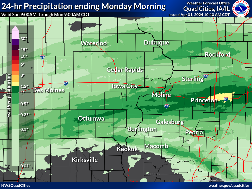
| 3-Day Overview Map | 24-hr Rainfall Ending 9am Monday |
24-hr Rainfall Ending 9am Tuesday |
|
 |
 |
 |
|
|
24-hr Rainfall Ending 9am Wednesday |
|||
.png) |
|||
...Highest 3-Day Rainfall Reports...

Observations are collected from a variety of sources with varying
equipment and exposures. We thank all volunteer weather observers
for their dedication. Not all data listed are considered official.

Location                     Amount    Time/Date       Provider
De Witt 5.4 ENE              4.37 in   0700 AM 04/03   COCORAHS
Mount Carroll 6.8 NNW        4.07 in   0730 AM 04/03   COCORAHS
Ainsworth 7.4 N              3.87 in   0700 AM 04/03   COCORAHS
2 N Muscatine                3.79 in   0700 AM 04/03   COOP
4 W Center Junction          3.71 in   0700 AM 04/03   COCORAHS
Illinois City 6.7 SW         3.69 in   0800 AM 04/03   COCORAHS
De Witt                      3.67 in   0800 AM 04/03   COOP
Viola 0.4 E                  3.64 in   0700 AM 04/03   COCORAHS
Aledo                        3.54 in   0630 AM 04/03   COOP
Riverdale 0.5 N              3.54 in   0700 AM 04/03   COCORAHS
Elizabeth                    3.53 in   0630 AM 04/03   COOP
Davenport 4.3 NE             3.53 in   0700 AM 04/03   COCORAHS
Davenport 0.9 WNW            3.52 in   0700 AM 04/03   COCORAHS
Eldridge 0.7 SSW             3.51 in   0700 AM 04/03   COCORAHS
Bettendorf 1.6 W             3.47 in   0730 AM 04/03   COCORAHS
Wellman 4.0 E                3.47 in   0545 AM 04/03   COCORAHS
Fairfield 5.7 NNE            3.46 in   0700 AM 04/03   COCORAHS
Hanover 0.2 NW               3.46 in   0700 AM 04/03   COCORAHS
Bellevue 12.2 NW             3.42 in   0735 AM 04/03   COCORAHS
Nichols 2.5 NNW              3.41 in   0700 AM 04/03   COCORAHS
Freeport 4.3 W               3.32 in   0500 AM 04/03   COCORAHS
Tipton 0.3 ESE               3.29 in   0700 AM 04/03   COCORAHS
Davenport 2.1 N              3.25 in   0730 AM 04/03   COCORAHS
Iowa City 2.3 E              3.24 in   0700 AM 04/03   COCORAHS
, IL                         3.19 in   0700 AM 04/03   COCORAHS
New Windsor 2.0 N            3.18 in   0700 AM 04/03   COCORAHS
Moline 0.7 NNE               3.11 in   0800 AM 04/03   COCORAHS
Fairfield                    3.10 in   0800 AM 04/03   COOP
Iowa City                    3.10 in   0700 AM 04/03   COOP
Galena 0.8 WSW               3.10 in   0700 AM 04/03   COCORAHS
Anamosa 0.6 ESE              3.07 in   0902 AM 04/03   COCORAHS
Fairfield                    3.06 in   0800 AM 04/03   COCORAHS
Maysville 0.1 SW             3.06 in   0800 AM 04/03   COCORAHS
Lowden                       3.04 in   0700 AM 04/03   COOP
Winslow 4.3 ESE              3.03 in   0700 AM 04/03   COCORAHS
Sigourney                    3.03 in   0700 AM 04/03   COOP
Tipton 0.7 N                 3.02 in   0800 AM 04/03   COCORAHS
Iowa City 1.0 NE             2.97 in   0700 AM 04/03   COCORAHS
Morning Sun 1.7 E            2.94 in   0800 AM 04/03   COCORAHS
Lena 0.3 SSE                 2.92 in   0700 AM 04/03   COCORAHS
West Branch 2.3 SSW          2.91 in   0600 AM 04/03   COCORAHS
Wapello 5.4 SE               2.91 in   0700 AM 04/03   COCORAHS
, IL                         2.91 in   0730 AM 04/03   COCORAHS
Davis 0.5 N                  2.90 in   0830 AM 04/03   COCORAHS
Stockton 3.4 NNE             2.89 in   0755 AM 04/03   COCORAHS
Farmington 3.5 W             2.83 in   0600 AM 04/03   COCORAHS
Washington 2 SSW             2.83 in   0700 AM 04/03   COOP
Stockton 3 Nne               2.81 in   0735 AM 04/03   COOP
Farmington 2.4 W             2.80 in   0600 AM 04/03   COCORAHS
Clarence 3.9 S               2.78 in   0700 AM 04/03   COCORAHS
Farmington 0.3 NW            2.77 in   0600 AM 04/03   COCORAHS
Farmington 0.4 NNW           2.74 in   0600 AM 04/03   COCORAHS
Fairfield 0.4 SE             2.72 in   0732 AM 04/03   COCORAHS
Coralville 1.3 SE            2.71 in   0715 AM 04/03   COCORAHS
Taylor Ridge 1.1 N           2.71 in   0700 AM 04/03   COCORAHS
Coralville 1.4 S             2.70 in   0800 AM 04/03   COCORAHS
Center Junction 2.6 W        2.70 in   0800 AM 04/03   COCORAHS
Washington 5.8 SW            2.70 in   0700 AM 04/03   COCORAHS
Geneseo 2.0 NW               2.68 in   0500 AM 04/03   COCORAHS
Monticello                   2.62 in   0600 AM 04/03   COOP
Freeport 2.9 WSW             2.57 in   0900 AM 04/03   COCORAHS
Kewanee 1 E                  2.57 in   0700 AM 04/03   COOP
Solon 0.4 WNW                2.55 in   0430 AM 04/03   COCORAHS
Anamosa 3 SSW                2.51 in   0700 AM 04/03   COOP
Camanche 1.2 W               2.49 in   0700 AM 04/03   COCORAHS
Dubuque 1.4 WNW              2.47 in   0700 AM 04/03   COCORAHS
North Liberty 0.7 SSW        2.45 in   0800 AM 04/03   COCORAHS
Park View 0.2 WSW            2.44 in   0700 AM 04/03   COCORAHS
Solon 0.3 ESE                2.41 in   0700 AM 04/03   COCORAHS
Charlotte 1.9 WNW            2.39 in   0700 AM 04/03   COCORAHS
Solon 4.2 SSW                2.39 in   0900 AM 04/03   COCORAHS
Wapello 0.2 S                2.33 in   0700 AM 04/03   COCORAHS
Dubuque 1.0 SE               2.31 in   0730 AM 04/03   COCORAHS
Oxford Junction 2.9 ENE      2.30 in   0900 AM 04/03   COCORAHS
Galva 0.4 NW                 2.27 in   0700 AM 04/03   COCORAHS
Dallas City 3.0 SSE          2.26 in   0600 AM 04/03   COCORAHS
Clinton 1.7 NNW              2.25 in   0600 AM 04/03   COCORAHS
Coal Valley 2.6 E            2.23 in   0800 AM 04/03   COCORAHS
Calamus 2.0 NE               2.21 in   0700 AM 04/03   COCORAHS
Davenport 1.0 NE             2.21 in   0600 AM 04/03   COCORAHS
East Dubuque 1.7 SE          2.21 in   0700 AM 04/03   COCORAHS
Mount Union 3.6 S            2.14 in   0900 AM 04/03   COCORAHS
Cedar Rapids 5.8 N           2.14 in   0700 AM 04/03   COCORAHS
New London 1.5 SW            2.11 in   0700 AM 04/03   COCORAHS
Tiffin 1.2 NE                2.11 in   0700 AM 04/03   COCORAHS
Robins 0.8 SE                2.11 in   0700 AM 04/03   COCORAHS
La Harpe 0.7 E               2.11 in   0930 AM 04/03   COCORAHS
Green Rock                   2.10 in   0900 AM 04/03   COCORAHS
Stockton 5.9 WNW             2.09 in   0700 AM 04/03   COCORAHS
2 WSW Yarmouth               2.08 in   0700 AM 04/03   COCORAHS
La Moille 0.2 NNE            2.08 in   0800 AM 04/03   COCORAHS
Manchester                   2.08 in   0700 AM 04/03   COOP
Donnellson                   2.07 in   0700 AM 04/03   COOP
La Harpe                     2.04 in   0800 AM 04/03   COOP
 |
Media use of NWS Web News Stories is encouraged! NWS Quad Cities Past Events Page: weather.gov/dvn/events |
|