Scattered severe thunderstorms capable of damaging wind gusts and some hail are expected this afternoon and evening from the Upper Ohio River Valley into the Northeast, and from the Appalachians into the Mid-Atlantic States. Excessive rainfall from heavy thunderstorms may produce areas of flash flooding from southern New Mexico into the western and northern Gulf Coast into Wednesday. Read More >
Overview
|
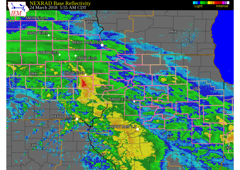
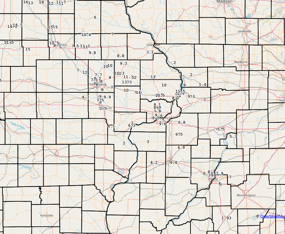
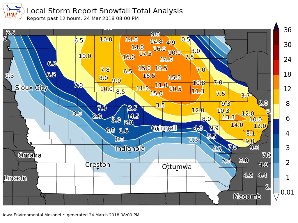
An early spring snow storm impacted much of the region Friday, March 23rd and Saturday, March 24th; as a strong low pressure system tracked east across Kansas and Missouri. This system brought heavy rain and snow to much of eastern Iowa, northwest Illinois, and northeast Missouri. Snow fell from northern Iowa through much of eastern Iowa into central and east central Illinois. A very sharp cutoff of snowfall was seen with this system. Snowfall totals between 2 and 8 inches were common, with the heaviest snow of 8 to 14 inches falling in a 20 mile wide line from Mason City, to Anamosa, to Clinton, IA. |
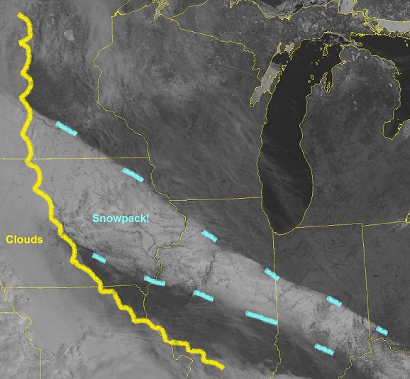 Satellite Image of 3/24/2018 Snow Event (Image from the afternoon of 3/25/2018) |
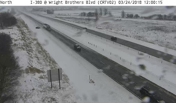
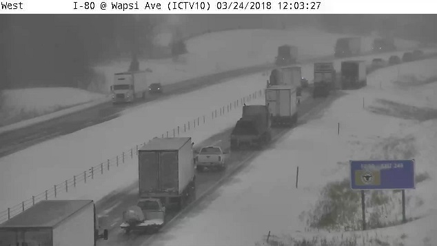
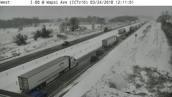
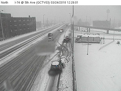
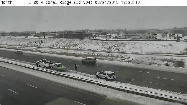
Webcam Photos Courtesy Iowa DOT
12:00-12:30 PM 3/24/2018
 |
 |
 |
 |
 |
|
Storm Reports
 |
 |
 |
|
| Interactive Map Link | Iowa Snowfall Analysis Courtesy Iowa Environmental Mesonet |
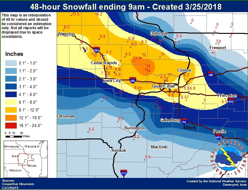
48-hr Local Snowfall Ending 9AM 3/25 |
|
 |
 |
||
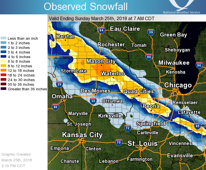
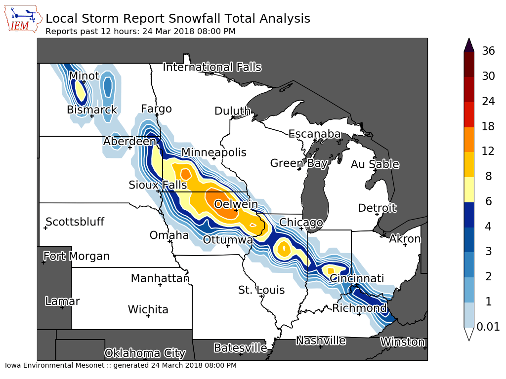
| 48-hr Regional Snowfall | Midwest Snowfall Analysis Courtesy Iowa Environmental Mesonet |
||
SNOW REPORTS LISTED BY AMOUNT INCHES LOCATION ST COUNTY TIME ------ ----------------------- -- -------------- ------- 14.0 LOWDEN IA CEDAR 0437 PM 13.3 OLIN IA JONES 0517 PM 12.0 OLIN IA JONES 0121 PM 12.0 WYOMING IA JONES 0522 PM 12.0 3 NNW SHELLSBURG IA BENTON 0435 PM 11.9 2 ENE CLINTON IA CLINTON 0416 PM 11.5 1 NW FULTON IA CLINTON 0528 PM 11.0 1 E INDEPENDENCE IA BUCHANAN 0348 PM 10.0 2 SW PRAIRIEBURG IA LINN 0353 PM 10.0 FULTON IL WHITESIDE 0315 PM 9.9 SOLON IA JOHNSON 0456 PM 9.8 QUASQUETON IA BUCHANAN 0645 PM 9.6 MOLINE QUAD-CITY AIRPOR IL ROCK ISLAND 0705 PM 9.3 1 NNW MONTICELLO IA JONES 0435 PM 9.0 2 N ELY IA LINN 0751 PM 9.0 3 E COU FALLS IA JOHNSON 0610 PM 9.0 1 NW DAVENPORT IA SCOTT 0711 PM 8.9 ELDRIDGE IA SCOTT 0800 PM 8.8 HOPKINTON IA DELAWARE 0520 PM 8.5 1 N CREDIT ISLAND IA SCOTT 0700 PM 8.2 CAMANCHE IA CLINTON 0619 PM 8.1 LONG GROVE IA SCOTT 0352 PM 8.0 1 SSW NORTH LIBERTY IA JOHNSON 0750 PM 8.0 2 W CEDAR RAPIDS IA LINN 0752 PM 8.0 ELDRIDGE IA SCOTT 0618 PM 8.0 1 SW CEDAR RAPIDS IA LINN 0754 PM 7.8 DAVENPORT AIRPORT IA SCOTT 0704 PM 7.7 2 NNE ROBINS IA LINN 0613 PM 7.5 2 NNW NORTH LIBERTY IA JOHNSON 0753 PM 7.1 2 WSW HIAWATHA IA LINN 0436 PM 7.0 3 NE MUSCATINE IA MUSCATINE 0635 PM 7.0 1 ENE MOUNT VERNON IA LINN 0434 PM 7.0 1 W CAMBRIDGE IL HENRY 0714 PM 7.0 1 SSW CORDOVA IL ROCK ISLAND 0600 PM 7.0 BERTRAM IA LINN 0436 PM 7.0 1 ESE COMO IL WHITESIDE 0348 PM 6.8 1 N GENESEO IL HENRY 0714 PM 6.3 MUSCATINE IA MUSCATINE 0755 PM 6.0 3 WSW BETTENDORF IA SCOTT 0717 PM 5.8 1 N GENESEO IL HENRY 0435 PM 5.5 1 SE PRINCETON IL BUREAU 0432 PM 5.3 GRANVILLE IL PUTNAM 0550 PM 4.5 PRINCETON IL BUREAU 0358 PM 4.5 4 NNE GLADWIN IA LOUISA 0545 PM 4.2 MONMOUTH IL WARREN 0545 PM 3.7 DUBUQUE REGIONAL ARPT IA DUBUQUE 0706 PM 3.0 ALEDO IL MERCER 0747 PM 2.5 1 SW UNIVERSITY HEIGHTS IA JOHNSON 0600 PM 2.0 WAPELLO IA LOUISA 0623 PM 2.0 1 N HANOVER IL JO DAVIESS 0350 PM |
|||
 |
Media use of NWS Web News Stories is encouraged! Please acknowledge the NWS as the source of any news information accessed from this site. |
|