Scattered severe thunderstorms capable of damaging wind gusts and some hail are expected this afternoon and evening from the Upper Ohio River Valley into the Northeast, and from the Appalachians into the Mid-Atlantic States. Excessive rainfall from heavy thunderstorms may produce areas of flash flooding from southern New Mexico into the western and northern Gulf Coast into Wednesday. Read More >
 |
 |
||
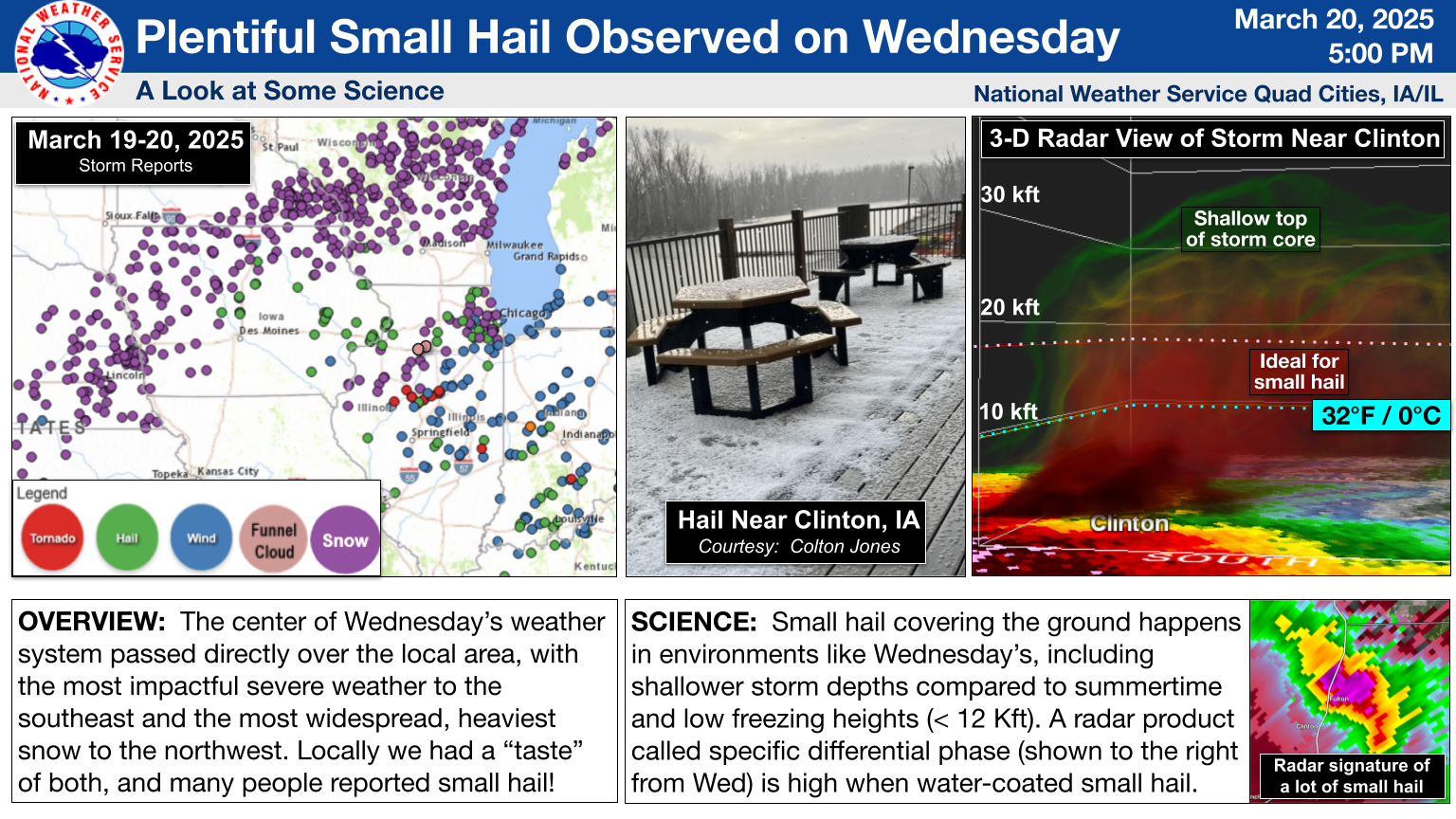
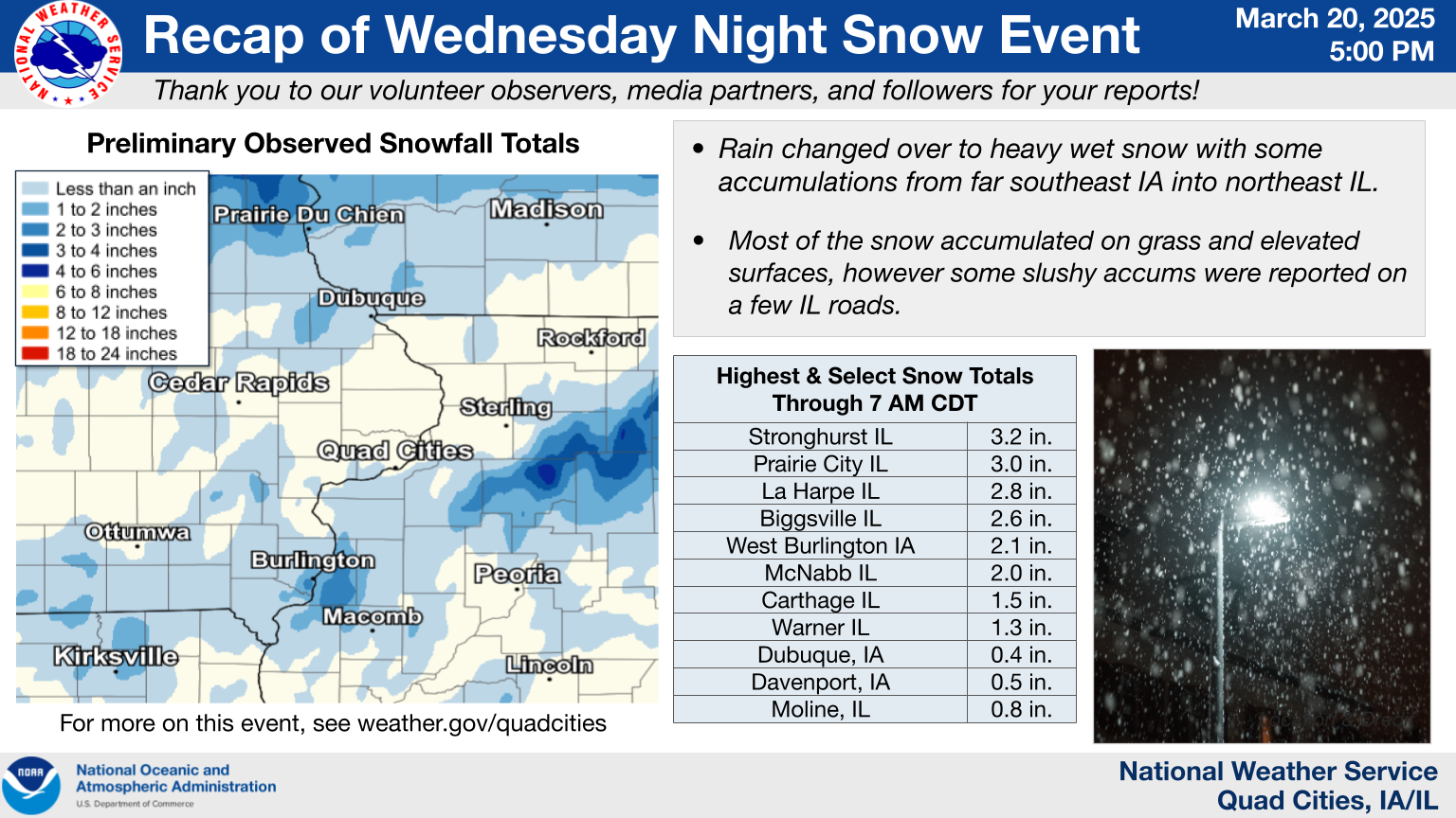
| Overview & Small Hail Recap | Snowfall Recap |
Other office event pages: Central Illinois (Lincoln) | Northern Illinois (Chicago)
Wind
Public Information Statement
National Weather Service Quad Cities IA IL
508 PM CDT Thu Mar 20 2025

...HIGHEST WIND REPORTS FROM MARCH 19-20 2025...

These were the highest gusts from the March 19-20 period, which
included thunderstorm gusts during the afternoon of March 19 as
well as strong non-thunderstorm gusts that were widespread on the
evening of the 19th into the early hours of the 20th.

Observations are collected from a variety of sources with varying
equipment and exposures. We thank all volunteer weather observers
for their dedication. Not all data listed are considered official.

Location                     Speed     Time/Date       Provider
---------------------------------------------------------------
Cedar Rapids Arpt            59 MPH    1145 PM 03/19   ASOS
Dubuque Arpt                 55 MPH    0828 PM 03/19   ASOS
Macomb                       54 MPH    0456 PM 03/19   CWOP
Iowa City Arpt               54 MPH    0551 PM 03/19   ASOS
Burlington Arpt              51 MPH    1208 PM 03/19   ASOS
Davenport Arpt               47 MPH    0516 PM 03/19   ASOS
Anamosa                      47 MPH    0550 PM 03/19   MESOWEST
Vinton Arpt                  46 MPH    0935 PM 03/19   AWOS
I-80 At I-380                45 MPH    0550 PM 03/19   MESOWEST
Urbana                       45 MPH    0925 PM 03/19   MESOWEST
Shellsburg                   44 MPH    0552 PM 03/19   CWOP
Mount Pleasant Arpt          44 MPH    1155 PM 03/19   AWOS
Cedar Rapids Us 30           44 MPH    0550 PM 03/19   MESOWEST
Us-30 At Us-218              44 MPH    1135 PM 03/19   MESOWEST
Marengo                      43 MPH    0525 PM 03/19   DAVIS
Washington Arpt              43 MPH    0135 AM 03/20   AWOS
Clinton Arpt                 43 MPH    1251 AM 03/20   AWOS
Fort Madison Arpt            43 MPH    0131 AM 03/20   AWOS
Dubuque                      42 MPH    0853 PM 03/19   CWOP
Independence                 42 MPH    0730 PM 03/19   CWOP
Olin                         41 MPH    0450 PM 03/19   CWOP
Freeport Arpt                41 MPH    0135 AM 03/20   AWOS
Independence Arpt            41 MPH    0915 PM 03/19   AWOS
Macomb Arpt                  41 MPH    0555 PM 03/19   AWOS
Sterling/Rock Falls Arpt     41 MPH    1100 PM 03/19   AWOS
Quasqueton                   40 MPH    0700 PM 03/19   CWOP
Quad City Intl Arpt          40 MPH    0156 AM 03/20   ASOS
Burlington Arpt              39 MPH    0109 AM 03/20   ASOS
Fairfield Arpt               39 MPH    1155 PM 03/19   AWOS
Davenport                    39 MPH    1245 AM 03/20   MESOWEST
Low Moor                     39 MPH    1256 AM 03/20   MESOWEST
Fairfax                      38 MPH    1100 PM 03/19   DAVIS
Keokuk Arpt                  38 MPH    0455 PM 03/19   AWOS
Muscatine Arpt               38 MPH    0135 AM 03/20   AWOS
Cedar Rapids I-380           38 MPH    0910 PM 03/19   MESOWEST
Iowa City Us 218             38 MPH    0550 PM 03/19   MESOWEST
Us-30 Mt Vernon              38 MPH    1135 PM 03/19   MESOWEST

Observations are collected from a variety of sources with varying
equipment and exposures. We thank all volunteer weather observers
for their dedication. Not all data listed are considered official.

$$

Gross/Friedlein
"Dirty Rain"
 |
|
||
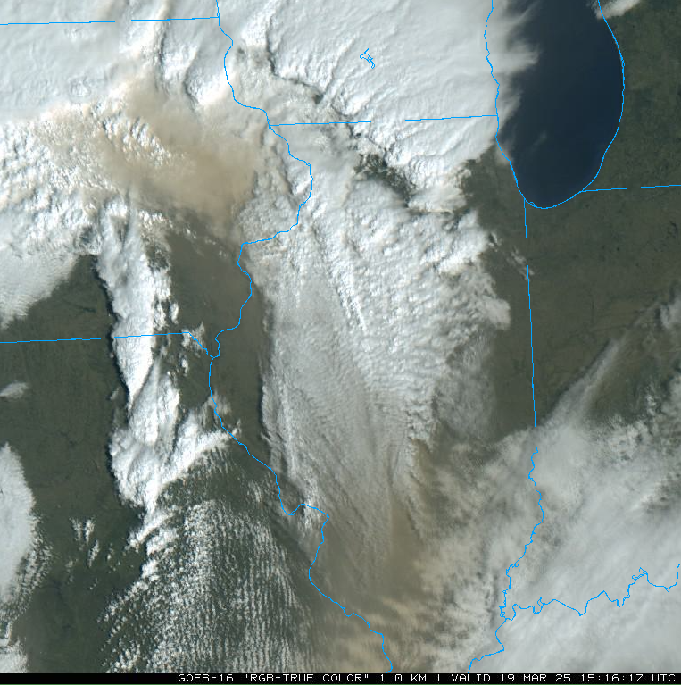
| Satellite image showing the dust between clouds. | March 19, 12 P.M. surface weather map, showing the center of the weather system (low pressure) approaching the area, with a dry line annotated in gold. This feature demarks a surge of drier air from the southwest. Given the strength of the low pressure, the draw of this drier air extended all the way back to the Southern Plains and even eastern portions of the Desert Southwest. This was the origin area of the dust and dirt. (Map courtesy Chauncy Shulttz, NWS Bismarck). |
Many people reported dust or dirt on their vehicles after the rain. Dust in the air can serve as condensation nuclei for tiny droplets to form that may eventually become raindrops, or may start as snowflakes if far enough aloft. That likely happened with the dust and dirt steered in on strong southwest winds aloft on March 19th. Some of the "dirty rain" was also likely simply from the falling rain drops colliding with the dust particles on their way downward.
Snow Totals
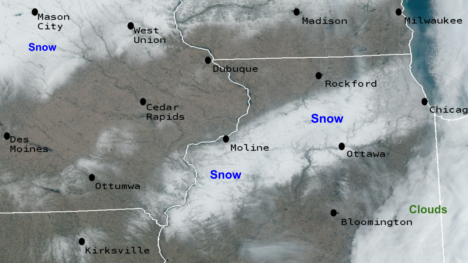 |
| Snow cover from the event as seen from visible satellite imagery on March 20. |
24 hour snow fall in inches,
Reported between Midnight and 9 AM,
Thursday March 20, 2025.
....ILLINOIS....

Stronghurst 0.4 SSW               3.2
La Harpe 0.7 E                    2.8
Romeoville                        2.5
McNabb 1.4 NW                     2.0
Steward                           2.0
Paw Paw                           2.0
Dallas City 3.0 SSE               1.6
Colchester 3.5 NE                 1.3
Aledo                             1.1
Lena 0.3 SSE                      1.0
Colona 0.5 ESE                    0.7
Bentley                           0.6
Moline 0.7 NNE                    0.4
Augusta                           0.4
Lanark 4.2 NNW                    0.1
....IOWA....

Hampton                           3.0
West Burlington 2.1 NW            2.1
Oelwein 1E                        1.2
Farmington 2.4 W                  1.0
Farmington 3.5 W                  1.0
Yarmouth 1.9 SW                   1.0
Fayette                           1.0
Donnellson                        1.0
Farmington 0.4 NNW                0.5
Farmington 0.3 NW                 0.5
Perry                             0.5
Salem 1S                          0.5
Lowden                            0.5
Wapello 5.4 SE                    0.4
Stanley                           0.4
Sigourney                         0.3
Fairfield 5.7 NNE                 0.2
Bettendorf 2.4 ENE                0.2
Davenport 4.3 NE                  0.2
Davenport 0.9 WNW                 0.2
Belle Plaine                      0.2
 |
Media use of NWS Web News Stories is encouraged! |
|