Dangerous to record breaking heat will build across the center of the nation and slowly build eastward this week. Wildfire conditions remain critical for the Southwest and portions of the Great Basin through Monday. For the northern Plains and upper Midwest, severe thunderstorms with the potential for large to very large hail and severe winds are the primary hazards. Read More >
Overview
|
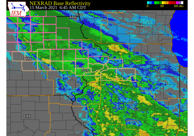
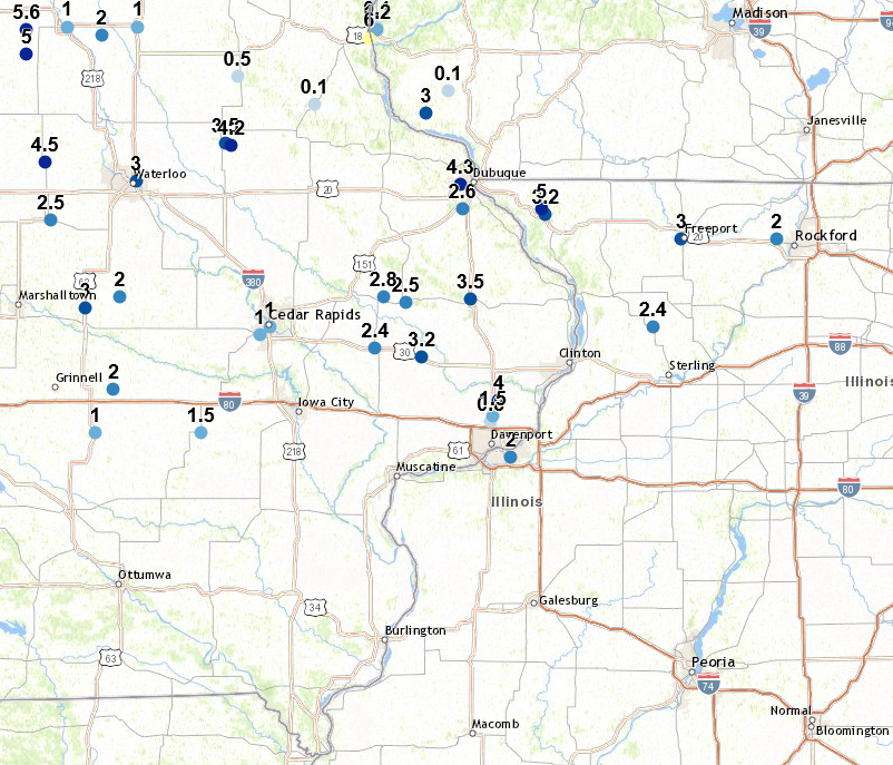
March 15, 2021 A winter storm brought a mix of precipitation and gusty winds to eastern Iowa, northwest Illinois, and far northeast Missouri on Monday, March 15. Precipitation initially began as snow, but began to mix with snow and sleet during the morning as cooler air moved into to the area aloft. Eventually, precipitation changed to all snow, and continued before winding down by midday and early afternoon. The highest snowfall amounts were reported in eastern Iowa along the Highway 20 corridor, where around 3-5 inches of snow fell. Amounts decreased to the south and east where more mixing occurred, with areas south of Interstate 80 seeing little to no snow accumulation. This was a rather precipitation heavy event outside of snow, with Moline, IL recording just under one inch of liquid. Official National Weather Service Observations
|
.gif) WPC - Surface Map and Radar Loop |
Snowfall Amounts
24 hour snow fall in inches,
for eastern Iowa, northwest and west central Illinois,
and northeast Missouri. Reported between Midnight and 9 AM,
Monday March 15, 2021.
THIS DATA WILL BE POPULATED ON MARCH 16 |
Storm Reports
March 15th Storm Reports
Courtesy IEM
|
|
PRELIMINARY LOCAL STORM REPORT...SUMMARY
NATIONAL WEATHER SERVICE QUAD CITIES IA IL
930 PM CDT MON MAR 15 2021

..TIME...   ...EVENT...      ...CITY LOCATION...     ...LAT.LON...
..DATE...   ....MAG....      ..COUNTY LOCATION..ST.. ...SOURCE....
            ..REMARKS..

0924 PM     SNOW             3 SW WINNESHIEK         42.32N 89.57W
03/15/2021  M3.0 INCH        STEPHENSON         IL   TRAINED SPOTTER

            EVENT TOTAL.

0745 PM     SNOW             2 WNW FREEPORT          42.30N 89.66W
03/15/2021  M3.5 INCH        STEPHENSON         IL   TRAINED SPOTTER

            EVENT TOTAL.

0729 PM     SNOW             1 SSW COAL VALLEY       41.43N 90.45W
03/15/2021  M1.0 INCH        ROCK ISLAND        IL   TRAINED SPOTTER


0725 PM     SNOW             NORA                    42.46N 89.94W
03/15/2021  M2.5 INCH        JO DAVIESS         IL   TRAINED SPOTTER

            EVENT TOTAL.

0700 PM     SNOW             MOLINE QUAD-CITY AIRPOR 41.45N 90.50W
03/15/2021  M1.8 INCH        ROCK ISLAND        IL   OFFICIAL NWS OBS

            EVENT TOTAL.

0700 PM     SNOW             DAVENPORT MUNICIPALITY  41.62N 90.58W
03/15/2021  M1.1 INCH        SCOTT              IA   OFFICIAL NWS OBS

            EVENT TOTAL. RECEIVED 0.3 INCHES FROM 1PM TO
            7PM.

0700 PM     SNOW             1 NW DUBUQUE REGIONAL A 42.41N 90.73W
03/15/2021  M3.8 INCH        DUBUQUE            IA   OFFICIAL NWS OBS

            EVENT TOTAL. RECEIVED 1.2 INCHES FROM 1PM TO
            7PM.

0647 PM     SNOW             3 N STOCKTON            42.40N 90.00W
03/15/2021  M3.5 INCH        JO DAVIESS         IL   CO-OP OBSERVER

            EVENT TOTAL.

0631 PM     SNOW             2 SE SCIOTO MILLS       42.33N 89.64W
03/15/2021  M2.0 INCH        STEPHENSON         IL   TRAINED SPOTTER


0626 PM     SNOW             2 W BETTENDORF          41.57N 90.51W
03/15/2021  M2.3 INCH        SCOTT              IA   NWS EMPLOYEE

            1.5 INCHES OF SNOW, 0.8 INCHES OF SLEET.

0450 PM     SNOW             1 WNW DUBUQUE           42.51N 90.72W
03/15/2021  M5.4 INCH        DUBUQUE            IA   PUBLIC


0441 PM     SNOW             COGGON                  42.28N 91.53W
03/15/2021  M3.0 INCH        LINN               IA   TRAINED SPOTTER

            EVENT TOTAL.

0433 PM     SNOW             6 SSE ELMOVILLE         42.19N 90.03W
03/15/2021  M3.7 INCH        CARROLL            IL   COCORAHS


0425 PM     SNOW             6 SSE ELMOVILLE         42.19N 90.03W
03/15/2021  M3.7 INCH        CARROLL            IL   COCORAHS

            EVENT TOTAL.

0408 PM     SNOW             RICKARDSVILLE           42.58N 90.88W
03/15/2021  M3.0 INCH        DUBUQUE            IA   TRAINED SPOTTER

            SNOW HAS ENDED.

0357 PM     SNOW             1 SSE DAVENPORT         41.54N 90.60W
03/15/2021  E1.2 INCH        SCOTT              IA   NWS EMPLOYEE

            EVENT TOTAL.

0351 PM     SNOW             DEWITT                  41.82N 90.55W
03/15/2021  M4.5 INCH        CLINTON            IA   NWS EMPLOYEE

            EVENT TOTAL.

0340 PM     SNOW             MOUNT CARROLL           42.09N 89.98W
03/15/2021  M3.7 INCH        CARROLL            IL   TRAINED SPOTTER


0325 PM     SNOW             3 ENE FAIRFAX           41.94N 91.72W
03/15/2021  M1.0 INCH        LINN               IA   TRAINED SPOTTER


0321 PM     SNOW             1 NNE MOLINE            41.49N 90.48W
03/15/2021  M2.0 INCH        ROCK ISLAND        IL   NWS EMPLOYEE

            1 INCH OF SNOW, 1 INCH OF SLEET.

0321 PM     SNOW             1 NW MAQUOKETA          42.07N 90.68W
03/15/2021  M3.5 INCH        JACKSON            IA   TRAINED SPOTTER

            EVENT TOTAL.

0310 PM     SNOW             ELDRIDGE                41.64N 90.57W
03/15/2021  M1.5 INCH        SCOTT              IA   PUBLIC


0309 PM     SNOW             FREEPORT                42.29N 89.64W
03/15/2021  M3.0 INCH        STEPHENSON         IL   PUBLIC

            VIA SOCIAL MEDIA.

0304 PM     SNOW             1 NW CENTER GROVE       42.49N 90.73W
03/15/2021  M4.3 INCH        DUBUQUE            IA   TRAINED SPOTTER

            SINCE 905 AM.

0303 PM     SNOW             2 ENE HAZLETON          42.63N 91.86W
03/15/2021  M4.2 INCH        BUCHANAN           IA   CO-OP OBSERVER

            UPDATED SNOWFALL TOTAL.

0245 PM     SNOW             GALENA TERRITORY        42.40N 90.33W
03/15/2021  M5.0 INCH        JO DAVIESS         IL   TRAINED SPOTTER


0239 PM     SNOW             PARK VIEW               41.70N 90.54W
03/15/2021  M4.0 INCH        SCOTT              IA   NWS EMPLOYEE


0219 PM     SNOW             2 SE GALENA TERRITORY   42.38N 90.31W
03/15/2021  M3.2 INCH        JO DAVIESS         IL   TRAINED SPOTTER

            SNOW HAS ENDED.

0115 PM     SNOW             3 SSW CENTER JUNCTION   42.08N 91.11W
03/15/2021  M2.8 INCH        JONES              IA   TRAINED SPOTTER


0115 PM     SNOW             WYOMING                 42.06N 91.00W
03/15/2021  M2.5 INCH        JONES              IA   TRAINED SPOTTER


0115 PM     SNOW             STANWOOD                41.89N 91.15W
03/15/2021  M2.4 INCH        CEDAR              IA   TRAINED SPOTTER
|
|
|
 |
Media use of NWS Web News Stories is encouraged! Please acknowledge the NWS as the source of any news information accessed from this site. |
|