Scattered severe thunderstorms capable of damaging wind gusts and some hail are expected this afternoon and evening from the Upper Ohio River Valley into the Northeast, and from the Appalachians into the Mid-Atlantic States. Excessive rainfall from heavy thunderstorms may produce areas of flash flooding from southern New Mexico into the western and northern Gulf Coast into Wednesday. Read More >
 |
 |
||
| Summary Graphic | Hail Swaths During Event |
Fast Facts
Select a tornado from the table to zoom into the track and view more information. The default table view is limited to 8 tracks, but can be scrolled by a mouse wheel or dynamically expanded. Additionally, the table can fill the entire window by clicking the small circular expanding arrow icon at the very top right of the table and returned to its original size by clicking the button again. The side information panel that opens over the map can be closed using the "X" on the upper right corner of the pop-up. Zoom into the map and click damage points to see detailed information and pictures from the surveys.
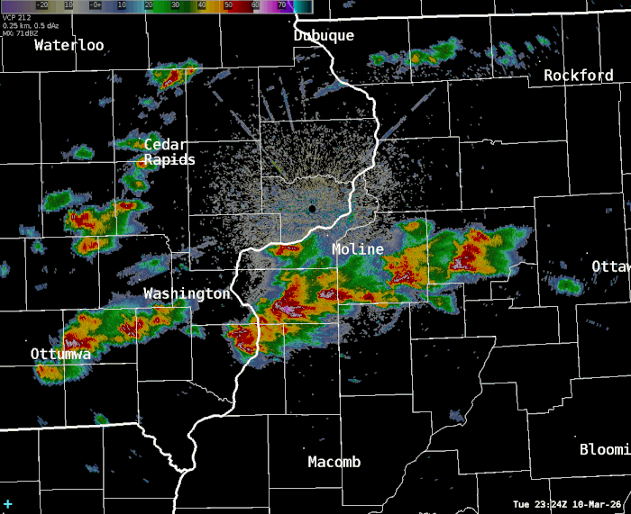
Numerous severe thunderstorms developed over the region late Tuesday afternoon and persisted into the evening, producing widespread large hail. No injuries or fatalities in the NWS Quad Cities CWA with these storms.
The largest hail, which was to dangerous levels if being caught outside in it, was 2.75" in diameter (baseball size), was reported near West Branch in Johnson County, IA, and near Davis and Lena in Stephenson County, IL.
In just the one hour span from 6:30 to 7:30 P.M., 51 reports of severe hail were received by the NWS Quad Cities office.
There were 10 total reports of significant hail (2+" in diameter) in the NWS Quad Cities County Warning Area (DVN). In our period of record, that is the third most significant hail reports with an event, behind April 7, 2020 (14) and April 4, 2023 (12).
The total number of significant hail reports was greater than the annual average we receive (6)!
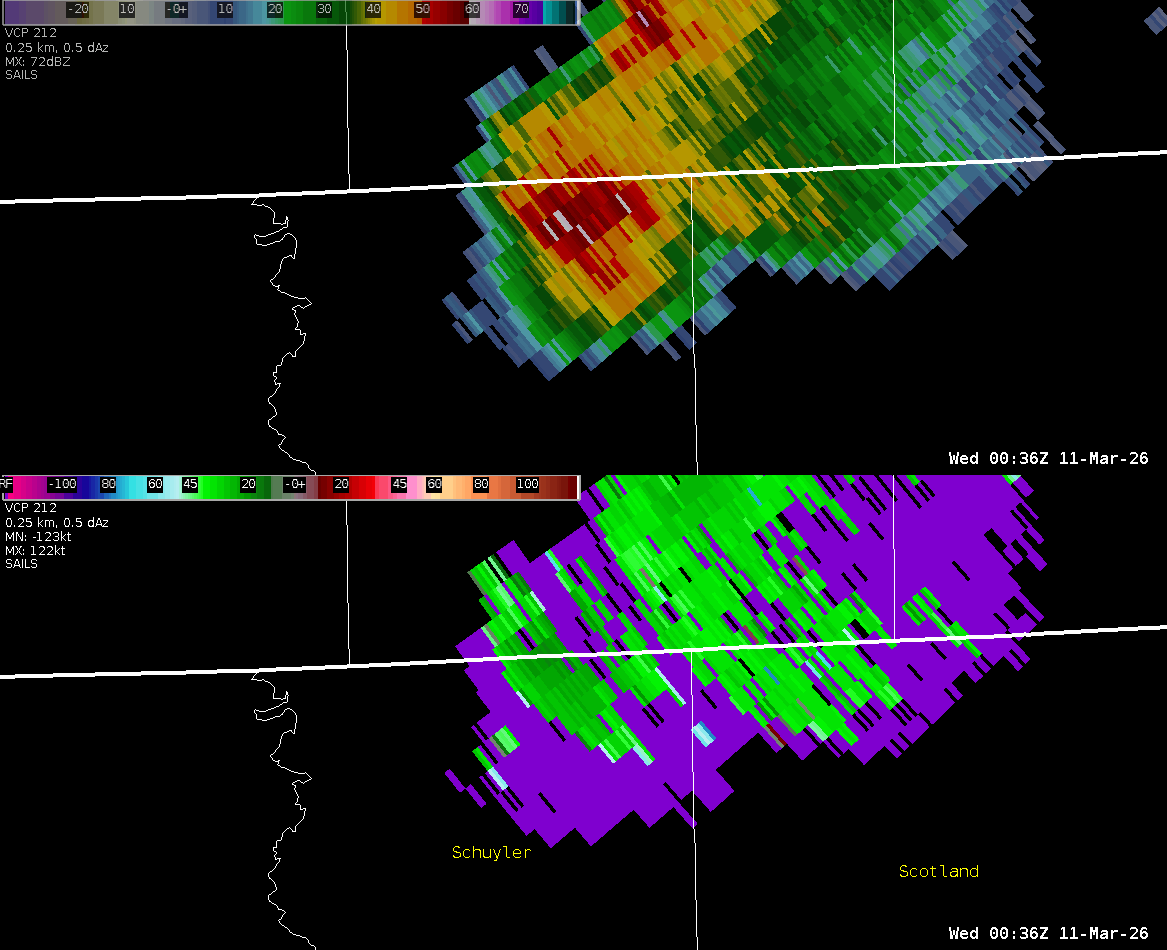
Many storms had rotation, and a few of them were persistent and in a favorable environment to warrant Tornado Warnings. One of these storms produced three EF1 tornadoes near Donnellson, IA in Lee County as documented by an NWS Damage Survey Team. Damage was mainly to outbuildings and trees. There were the earliest tornadoes in a calendar year in Lee County, IA since 1967.
Other noteworthy storms that prompted Tornado Warnings included:
A storm near Kewanee, IL had reports of visible rotation as it passed near the city, although no tornado or damage was reported.
The NWS Central Illinois office conducted a storm damage survey near the far southern Putnam County border as part of a storm that moved across Stark and Marshall Counties in IL. The tornado they confirmed was south of the county border by just one mile.
The threat of severe weather had been mentioned for several days, and watches were in effect in advance too. The local office issued 39 total SVR and TOR Warnings, which was one of the higher totals our office has issued in a calendar day, speaking to the event's widespread nature of supercell storms (i.e. rotating storms that can support large hail growth).
This was part of a larger regional outbreak, including hail to 5+ inches and damaging tornadoes with multiple fatalities in the NWS Chicago area, and some tornadoes in the NWS Central Illinois area.
Tornadoes
Select a tornado from the table to zoom into the track and view more information. The default table view is limited to 8 tracks, but can be scrolled by a mouse wheel or dynamically expanded. Additionally, the table can fill the entire window by clicking the small circular expanding arrow icon at the very top right of the table and returned to its original size by clicking the button again. The side information panel that opens over the map can be closed using the "X" on the upper right corner of the pop-up. Zoom into the map and click damage points to see detailed information and pictures from the surveys.
 |
 |
 |
| Lee County, IA Tornado #1 | Lee County, IA Tornado #2 | Lee County, IA Tornado #3 |
Public Information Statement on March 10th Event Damage Surveys
|
NOTE: times shown below are local to your device's time zone. |

The Enhanced Fujita (EF) Scale classifies tornadoes into the following categories:
| EF0 Weak 65-85 mph |
EF1 Moderate 86-110 mph |
EF2 Significant 111-135 mph |
EF3 Severe 136-165 mph |
EF4 Extreme 166-200 mph |
EF5 Catastrophic 200+ mph |
 |
|||||
| Tornadoes that fail to impact any ratable damage indicators on the EF-Scale are rated EF-Unknown (EF-U) | |||||
Storm Reports
| SPC Storm Reports: March 10, 2026 |
 |
Preliminary Local Storm Report...Summary
National Weather Service Quad Cities IA IL
636 PM CDT Thu Mar 12 2026

Significant hail and tornado reports are bolded.

..TIME...   ...EVENT...      ...CITY LOCATION...     ...LAT.LON...
..DATE...   ....MAG....      ..COUNTY LOCATION..ST.. ...SOURCE....
            ..REMARKS..

0551 PM     Hail             Seaton                  41.10N 90.80W
03/10/2026  E1.25 Inch       Mercer             IL   Public

            Delayed report via social media.

0621 PM     Hail             Buda                    41.33N 89.68W
03/10/2026  M1.00 Inch       Bureau             IL   Trained Spotter


0623 PM     Hail             Batavia                 40.99N 92.17W
03/10/2026  M1.50 Inch       Jefferson          IA   Fire Dept/Rescue


0631 PM     Funnel Cloud     Kewanee                 41.24N 89.93W
03/10/2026                   Henry              IL   Emergency Mngr

            EMA watched this funnel cloud within a
            rotating wall cloud before taking cover. No
            reports of it in contact with the ground.

0633 PM     Hail             2 N New Windsor         41.24N 90.44W
03/10/2026  M1.00 Inch       Henry              IL   Trained Spotter

            Nickel to quarter sized hail occurring right
            now. Increasing in intensity.

0635 PM     Hail             2 SE Davenport          41.53N 90.57W
03/10/2026  E1.00 Inch       Scott              IA   Trained Spotter


0636 PM     Hail             3 S Buck Creek          42.28N 91.34W
03/10/2026  M1.25 Inch       Jones              IA   Public


0639 PM     Hail             2 SE Davenport          41.54N 90.59W
03/10/2026  E1.00 Inch       Scott              IA   Public

            Report from mPING: Quarter (1.00 in.).

0639 PM     Hail             Wayland                 41.15N 91.66W
03/10/2026  M1.00 Inch       Henry              IA   Trained Spotter

            Occurring right now.

0640 PM     Hail             1 ENE Fairfield Municip 41.05N 91.96W
03/10/2026  M1.00 Inch       Jefferson          IA   Trained Spotter

            Lasted from 640 to 650 PM. Covered the deck.
            No wind.

0644 PM     Hail             1 SE Hanover            42.25N 90.27W
03/10/2026  M1.50 Inch       Jo Daviess         IL   Public


0645 PM     Hail             1 SW Perlee             41.07N 91.92W
03/10/2026  M1.00 Inch       Jefferson          IA   Trained Spotter

            Up to quarter size hail. Time of the event
            was estimated using radar.

0650 PM     Hail             3 N Derinda Center      42.29N 90.18W
03/10/2026  M1.25 Inch       Jo Daviess         IL   Trained Spotter


0653 PM     Hail             2 NW Sharon Center      41.59N 91.69W
03/10/2026  M1.25 Inch       Johnson            IA   Public


0657 PM     Hail             2 SE Woodbine           42.32N 90.13W
03/10/2026  M2.00 Inch       Jo Daviess         IL   Public


0658 PM     Hail             3 ENE Cedar Rapids Muni 41.90N 91.67W
03/10/2026  M1.00 Inch       Linn               IA   Public

            Delayed report via social media. Verified by
            ruler measurement.

0658 PM     Hail             Princeton               41.38N 89.47W
03/10/2026  E1.00 Inch       Bureau             IL   Trained Spotter

            Corrects previous hail report from
            Princeton.

0700 PM     Hail             4 NE Cedar Rapids Munic 41.92N 91.65W
03/10/2026  M1.00 Inch       Linn               IA   Trained Spotter


0700 PM     Hail             Cascade                 42.30N 91.01W
03/10/2026  E1.00 Inch       Dubuque            IA   Public


0702 PM     Hail             3 ENE Cedar Rapids Muni 41.90N 91.66W
03/10/2026  M1.00 Inch       Linn               IA   Trained Spotter

            Occurring right now.

0703 PM     Hail             1 NNW Cascade           42.31N 91.02W
03/10/2026  M1.00 Inch       Dubuque            IA   Trained Spotter

            Via Social Media.

0703 PM     Hail             3 NE Cedar Rapids Munic 41.91N 91.66W
03/10/2026  E1.25 Inch       Linn               IA   Public

            Report from mPING: Half Dollar (1.25 in.).

0703 PM     Hail             3 SSE Cedar Rapids      41.93N 91.66W
03/10/2026  E2.00 Inch       Linn               IA   Trained Spotter

            Hail sizes between 1 to 2 inches in
            diameter. Time estimated by radar.

0704 PM     Hail             3 W Iowa City Municipal 41.63N 91.61W
03/10/2026  M2.50 Inch       Johnson            IA   Public


0705 PM     Hail             1 NNW Cascade           42.31N 91.02W
03/10/2026  M1.00 Inch       Dubuque            IA   Trained Spotter

            Via social media.

0706 PM     Hail             Albany                  41.79N 90.22W
03/10/2026  M1.00 Inch       Whiteside          IL   Trained Spotter


0707 PM     Hail             4 NE Cedar Rapids Munic 41.92N 91.66W
03/10/2026  M1.00 Inch       Linn               IA   Emergency Mngr


0707 PM     Hail             Princeton               41.38N 89.47W
03/10/2026  E2.25 Inch       Bureau             IL   Public


0708 PM     Hail             1 E Iowa City Municipal 41.64N 91.53W
03/10/2026  M1.00 Inch       Johnson            IA   Trained Spotter

            Delayed report. Marble to quarter sized
            hail.

0708 PM     Hail             1 SE Clinton            41.84N 90.22W
03/10/2026  E1.25 Inch       Clinton            IA   Public

            Report from mPING: Half Dollar (1.25 in.).

0709 PM     Hail             1 E Camanche            41.80N 90.26W
03/10/2026  E1.00 Inch       Clinton            IA   Public


0709 PM     Hail             2 E Dubuque Regional Ar 42.40N 90.69W
03/10/2026  M1.25 Inch       Dubuque            IA   Public


0710 PM     Hail             1 ESE Iowa City         41.65N 91.51W
03/10/2026  M1.00 Inch       Johnson            IA   Trained Spotter

            Delayed report.

0710 PM     Hail             Fulton                  41.87N 90.16W
03/10/2026  M1.00 Inch       Whiteside          IL   Public


0713 PM     Hail             3 W Paralta             42.04N 91.51W
03/10/2026  M1.25 Inch       Linn               IA   Public

            1 mile east of Marion Airport.

0713 PM     Hail             2 SE Iowa City          41.64N 91.51W
03/10/2026  M1.25 Inch       Johnson            IA   Trained Spotter

            Occurring right now.

0714 PM     Hail             3 W Lena                42.37N 89.88W
03/10/2026  M2.75 Inch       Stephenson         IL   Public


0715 PM     Hail             2 SE Iowa City          41.64N 91.50W
03/10/2026  E1.00 Inch       Johnson            IA   Public


0715 PM     Hail             2 SE Iowa City          41.64N 91.51W
03/10/2026  M1.50 Inch       Johnson            IA   Trained Spotter

            Size increased since last report.

0715 PM     Hail             3 N Bernard             42.35N 90.83W
03/10/2026  M2.00 Inch       Dubuque            IA   Emergency Mngr

            Time estimated by radar.

0716 PM     Hail             2 SE Iowa City          41.64N 91.50W
03/10/2026  E1.25 Inch       Johnson            IA   Public

            Report from mPING: Half Dollar (1.25 in.).

0717 PM     Hail             1 N Bernard             42.33N 90.83W
03/10/2026  M1.00 Inch       Dubuque            IA   Trained Spotter


0718 PM     Hail             1 SE Princeton          41.37N 89.45W
03/10/2026  M1.50 Inch       Bureau             IL   Public

            Time estimated by radar.

0720 PM     Hail             Iowa City               41.66N 91.53W
03/10/2026  M1.00 Inch       Johnson            IA   Public

            10 minutes of quarter size hail. Hail is
            covering the ground.

0721 PM     Hail             1 E Iowa City           41.66N 91.51W
03/10/2026  E1.00 Inch       Johnson            IA   Public

            Report from mPING: Quarter (1.00 in.).

0722 PM     Hail             Princeton               41.38N 89.46W
03/10/2026  E1.00 Inch       Bureau             IL   Public

            Report from mPING: Quarter (1.00 in.).

0723 PM     Hail             3 SW West Branch        41.65N 91.39W
03/10/2026  M2.75 Inch       Johnson            IA   Public


0725 PM     Hail             West Branch             41.67N 91.35W
03/10/2026  M1.75 Inch       Cedar              IA   Public

            Time estimated by radar.

0725 PM     Hail             Lena                    42.38N 89.83W
03/10/2026  M2.00 Inch       Stephenson         IL   Public


0727 PM     Hail             1 SW Lena               42.37N 89.83W
03/10/2026  E1.00 Inch       Stephenson         IL   Public


0727 PM     Hail             2 WSW Damascus          42.36N 89.73W
03/10/2026  M1.25 Inch       Stephenson         IL   Public


0727 PM     Hail             3 SW Mc Connell         42.40N 89.77W
03/10/2026  M1.75 Inch       Stephenson         IL   Public


0730 PM     Hail             2 E Swedesburg          41.10N 91.51W
03/10/2026  E1.25 Inch       Henry              IA   Public

            Delayed report via social media.

0730 PM     Hail             Bernard                 42.31N 90.83W
03/10/2026  E2.00 Inch       Dubuque            IA   Emergency Mngr


0732 PM     Hail             2 NW Kewanee            41.26N 89.95W
03/10/2026  M1.50 Inch       Henry              IL   Trained Spotter

            Time estimated.

0736 PM     Hail             2 W Dakota              42.40N 89.57W
03/10/2026  E1.00 Inch       Stephenson         IL   Public

            Report from mPING: Quarter (1.00 in.).

0739 PM     Hail             1 NE Rochester          41.67N 91.16W
03/10/2026  M1.50 Inch       Cedar              IA   Trained Spotter


0750 PM     Hail             1 N Davis               42.43N 89.42W
03/10/2026  M1.75 Inch       Stephenson         IL   Fire Dept/Rescue

            Time estimated by radar.

0752 PM     Hail             2 N Davis               42.45N 89.42W
03/10/2026  M2.75 Inch       Stephenson         IL   Trained Spotter


0754 PM     Hail             Kewanee                 41.24N 89.93W
03/10/2026  M1.00 Inch       Henry              IL   Public

            Delayed report.

0803 PM     Hail             1 NNE Centralia         42.49N 90.83W
03/10/2026  M1.00 Inch       Dubuque            IA   Trained Spotter

            lots of nickel to quarter.

0804 PM     Hail             Epworth                 42.44N 90.93W
03/10/2026  M1.75 Inch       Dubuque            IA   Fire Dept/Rescue

            Delayed report via EM. Mainly quarter to
            half dollar sized hail with some golfball
            hail.

0809 PM     Hail             Charlotte               41.96N 90.47W
03/10/2026  E1.25 Inch       Clinton            IA   Public

            Report from mPING: Half Dollar (1.25 in.).

0822 PM     Hail             1 S Mc Nabb             41.16N 89.21W
03/10/2026  E1.00 Inch       Putnam             IL   Public


0827 PM     Hail             1 NW Lake Summerset     42.46N 89.42W
03/10/2026  E1.00 Inch       Stephenson         IL   Public


0842 PM     Hail             2 N New Windsor         41.24N 90.44W
03/10/2026  E1.00 Inch       Henry              IL   Trained Spotter

            nickel to quarters.

0859 PM     Hail             1 SSW Cambridge         41.30N 90.20W
03/10/2026  E1.00 Inch       Henry              IL   Trained Spotter


0905 PM     Tornado          4 WSW Donnellson        40.62N 91.63W
03/10/2026                   Lee                IA   NWS Storm Survey

            An EF1 tornado with peak winds of 95 to 100
            mph begun its 1.5 mile long path by downing
            some tree branches. The tornado increased in
            strength causing damage to the door of a
            farm outbuilding along with damage to
            additional farm out buildings. The tornado
            continued east along 230th street, causing
            sporadic tree damage for around 1 mile. The
            tornado then strengthened even more near
            230th street and 160th avenue, where it
            destroyed two farm outbuildings and snapped
            numerous tree trunks. This is where the
            tornado was the strongest. Shortly after
            crossing 160th street, the tornado weakened
            and eventually dissipated.

0910 PM     Hail             2 SW Donnellson         40.62N 91.59W
03/10/2026  M1.50 Inch       Lee                IA   Public


0926 PM     Tornado          2 SSE Franklin          40.64N 91.50W
03/10/2026                   Lee                IA   NWS Storm Survey

            An EF1 tornado with max winds near 90 mph
            begun its 2.1 mile long path with damage to
            tree branches. The tornado then caused
            damage to some fascia on a house. It then
            crossed into Wilson Lake park where
            additional trees were downed. Some trees
            were uprooted with a couple of trees had
            their trunks snapped. Tree damage became
            more sporadic as the tornado continued east
            leading to minor tree damage through the
            remainder of its path.

0938 PM     Tornado          2 W Wever               40.71N 91.29W
03/10/2026                   Lee                IA   NWS Storm Survey

            In coordination with the Denmark, IA Fire
            Dept, an EF1 tornado with maximum winds of
            100 mph and path length of 1.2 miles was
            determined to have occurred on March 10.
            Numerous trees were snapped or uprooted, and
            one power pole was snapped. A large section
            of shingles was blown off a roof.

0950 PM     Tstm Wnd Gst     Burlington Regional Air 40.78N 91.13W
03/10/2026  M60 MPH          Des Moines         IA   ASOS

            KBRL reported a 52 knot wind gust.


&&
Rain Reports
Public Information Statement
National Weather Service Quad Cities IA IL
1257 PM CDT Wed Mar 11 2026

...Rainfall Reports from Tuesday and Tuesday Night...

These are rainfall reports through early Wednesday morning.

Observations are collected from a variety of sources with varying
equipment and exposures. We thank all volunteer weather observers
for their dedication. Not all data listed are considered official.

Location                     Amount    Time/Date       Provider
---------------------------------------------------------------
New Windsor 2.0 N            2.09 in   0700 AM 03/11   COCORAHS
Aledo                        1.79 in   0610 AM 03/11   COOP
Davis 1.5 NNE                1.65 in   0700 AM 03/11   COCORAHS
West Point 2.4 E             1.47 in   1100 AM 03/11   COCORAHS
Bettendorf, IA               1.42 in   1235 PM 03/11   CWOP
Fort Madison 7.7 N           1.40 in   0800 AM 03/11   COCORAHS
Kewanee 1 E                  1.18 in   0700 AM 03/11   COOP
Macomb, IL                   1.08 in   1237 PM 03/11   CWOP
0.9 W Keithsburg             1.08 in   1230 PM 03/11   HADS
Fort Madison 4.5 NNW         1.05 in   0800 AM 03/11   COCORAHS
Galena 0.8 WSW               1.04 in   0700 AM 03/11   COCORAHS
Lena 0.3 SSE                 1.04 in   0700 AM 03/11   COCORAHS
Burlington Arpt              1.03 in   1153 AM 03/11   ASOS
Farmington 3.5 W             1.00 in   0730 AM 03/11   COCORAHS
Davis 0.5 N                  1.00 in   0805 AM 03/11   COCORAHS
Farmington 2.4 W             0.99 in   0730 AM 03/11   COCORAHS
Farmington 0.3 NW            0.98 in   0730 AM 03/11   COCORAHS
Farmington 0.4 NNW           0.97 in   0730 AM 03/11   COCORAHS
McNabb 1.4 NW                0.96 in   0700 AM 03/11   COCORAHS
Burlington 0.8 SSE           0.90 in   0959 AM 03/11   COCORAHS
Dubuque Arpt                 0.85 in   1231 PM 03/11   ASOS
Middleburg                   0.81 in   1230 PM 03/11   CWOP
Burlington 6.5 SSW           0.80 in   0700 AM 03/11   COCORAHS
Spring Valley Airport        0.79 in   1245 PM 03/11   AWS
Wapello 5.4 SE               0.73 in   0700 AM 03/11   COCORAHS
Park View 0.2 WSW            0.68 in   0700 AM 03/11   COCORAHS
Fairfield 5.7 NNE            0.67 in   0700 AM 03/11   COCORAHS
Stockton 3.4 NNE             0.64 in   0730 AM 03/11   COCORAHS
Hanover 0.2 NW               0.63 in   0700 AM 03/11   COCORAHS
Kahoka                       0.62 in   1239 PM 03/11   CWOP
Macomb Arpt                  0.62 in   1235 PM 03/11   AWOS
Stockton 3 Nne               0.62 in   0730 AM 03/11   COOP
Atkinson 2.6 NNE             0.61 in   0800 AM 03/11   COCORAHS
Bellevue 12.2 NW             0.59 in   0745 AM 03/11   COCORAHS
New London                   0.59 in   0823 AM 03/11   COCORAHS
Stockton                     0.58 in   1230 PM 03/11   CWOP
Augusta                      0.57 in   0611 AM 03/11   COOP
Park View                    0.56 in   0730 AM 03/11   COCORAHS
Pecatonica River             0.54 in   1230 PM 03/11   HADS
Morning Sun 1.7 E            0.53 in   0800 AM 03/11   COCORAHS
New London                   0.52 in   1230 PM 03/11   CWOP
Wapello 0.2 S                0.51 in   0900 AM 03/11   COCORAHS
Photos
 |
 |
|
|
Hail in Bernard, IA Dubuque County EMA |
Hail covering the ground Iowa City, IA Iowa ARRL |
Lightning-illuminated wall cloud near Donnellson. Dave Tull |
Environment & Service
 |
 |
 |
 |
|
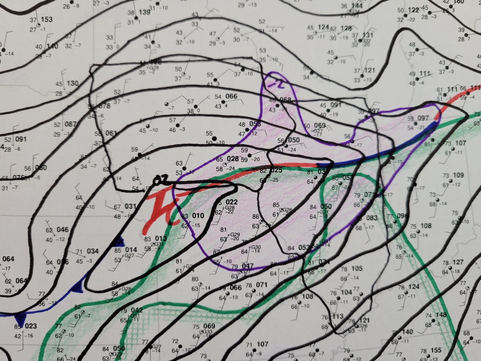
500 mb Analysis |
700 mb Analysis |
850 mb Analysis |
925 mb Analysis |
 |
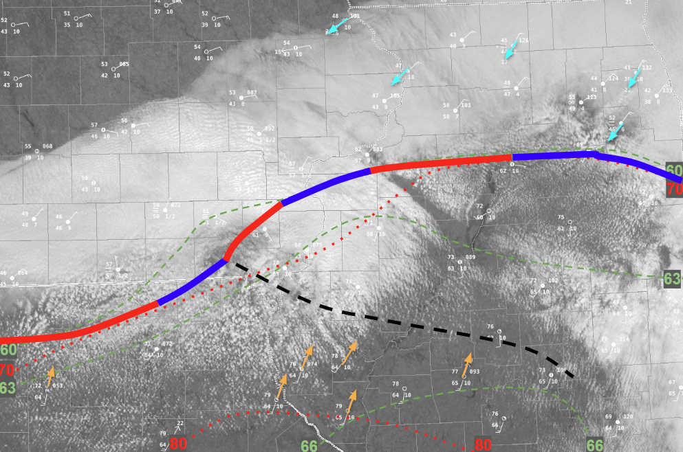 |
| Regional surface weather map March 10 afternoon (4 PM) | Mesoanalysis Map at March 10 afternoon (~2 P.M.) |
 |
 |
 |
 |
|
Most Unstable CAPE (Instability) Favorable for Strong Storms |
0-6 km Shear Favorable for Organized Storms |
Supercell Composite Favorability for Supercells |
Mid Level Lapse Rates Favorable for Severe Hail |
 |
 |
 |
 |
|
SPC Convective Outlook - 3PM |
Tornado Probabilities |
Severe Hail Probabilities |
Severe Wind Probabilities |
 |
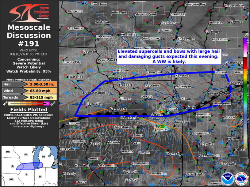 |
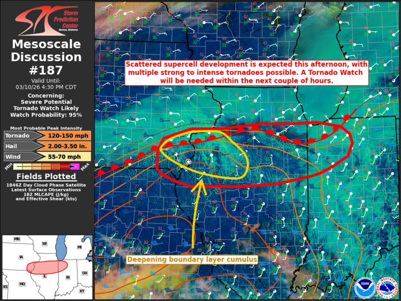
| Mesoscale Convective Discussion #187 | Mesoscale Convective Discussion #191 |
 |
 |
|
| Tornado Watch issued for central and southern areas at 3:55 P.M. | Severe Thunderstorm Watch issued for northern and central areas at 5:39 P.M. | Local Graphicast highlighting severe threat areas in advance issued at 5:52 P.M. |
 |
Media use of NWS Web News Stories is encouraged! |
|