Heat expands across the Desert Southwest, Plains, Mississippi Valley and Midwest into Monday. Fire weather concerns continue for portions of the Intermountain West. Active monsoonal moisture fuels thunderstorms over the Southwest with possible flash flooding. Tropical cyclone Fausto in the Pacific, should weaken as it approaches Hawaii; Dangerous surf, swells and rip currents are expected. Read More >
Overview
|
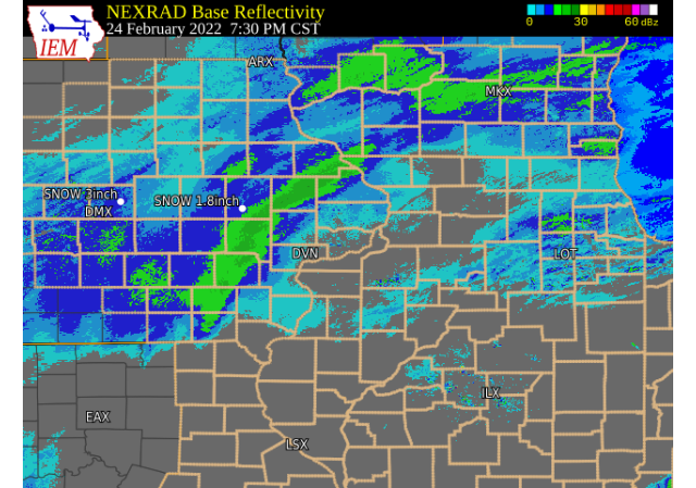
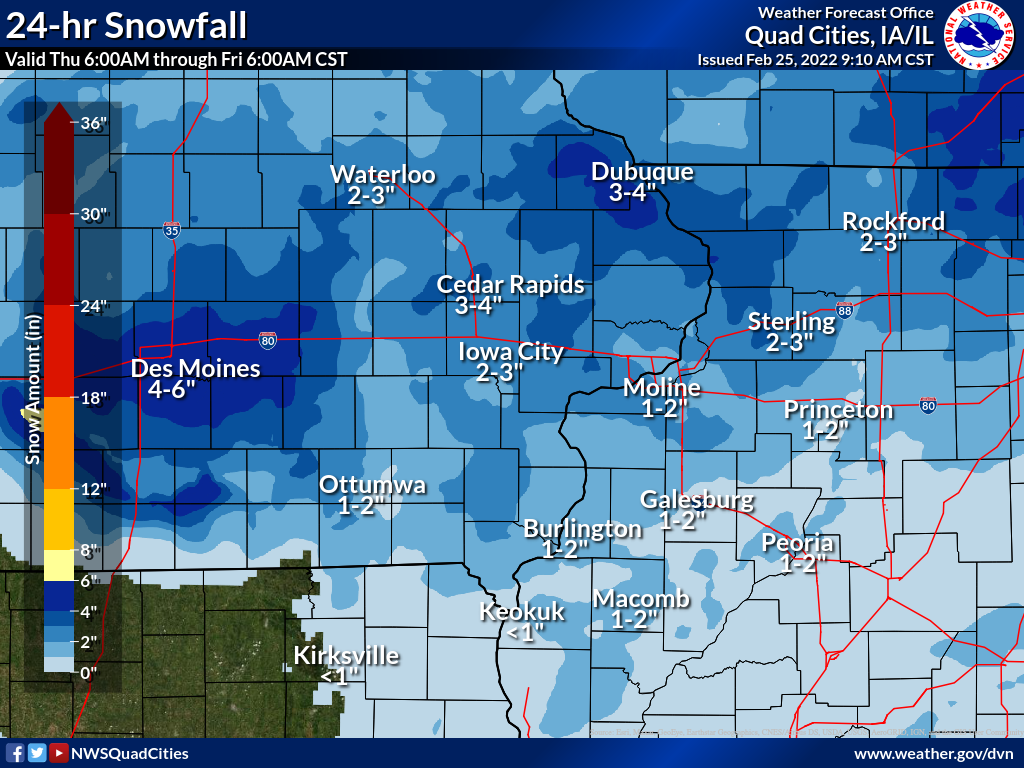
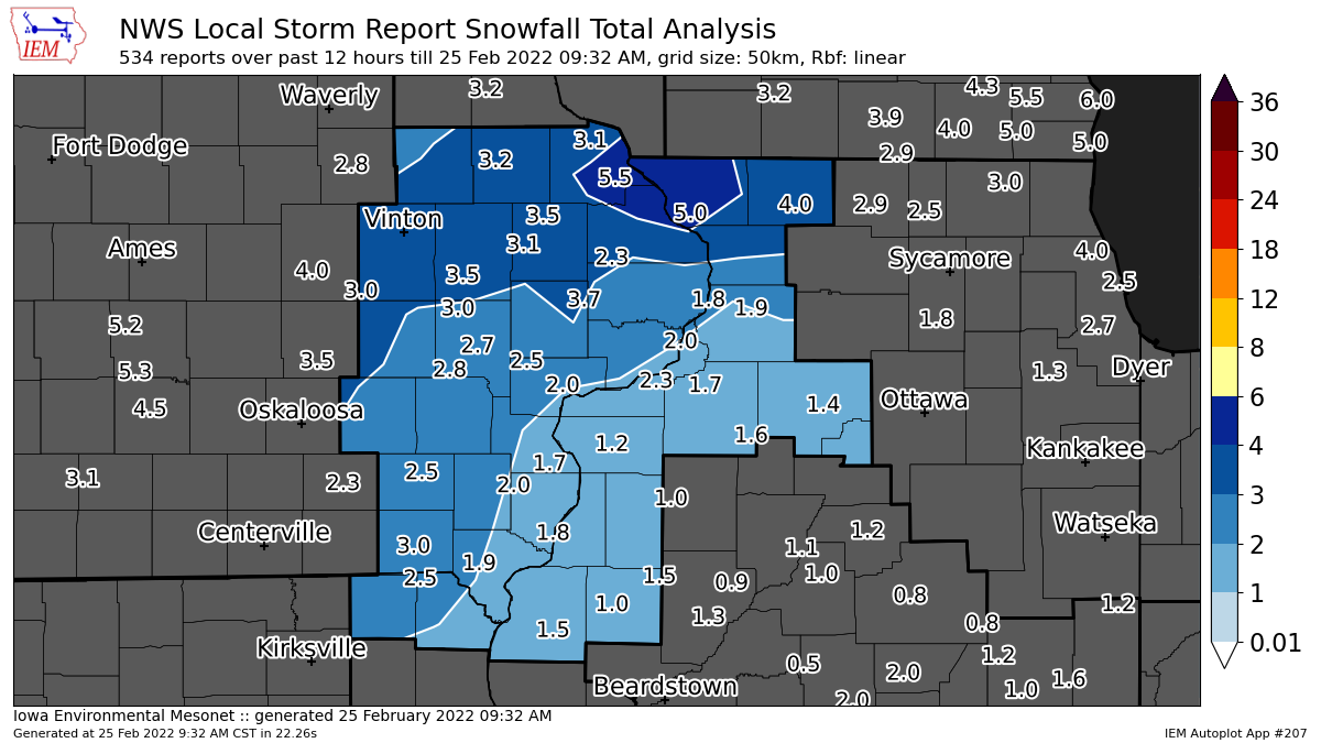
A winter storm brought widespread light and fluffy snow to much of eastern Iowa, northwest Illinois, and northeast Missouri Thursday afternoon - evening. This snow impacted the evening commute causing hazardous travel on area roads. Snowfall amounts were generally between 1-3 inches, with a few localized higher totals. Some light freezing drizzle was also common before the snow began for many locations. NWS Official Totals Moline: 2.1"
|
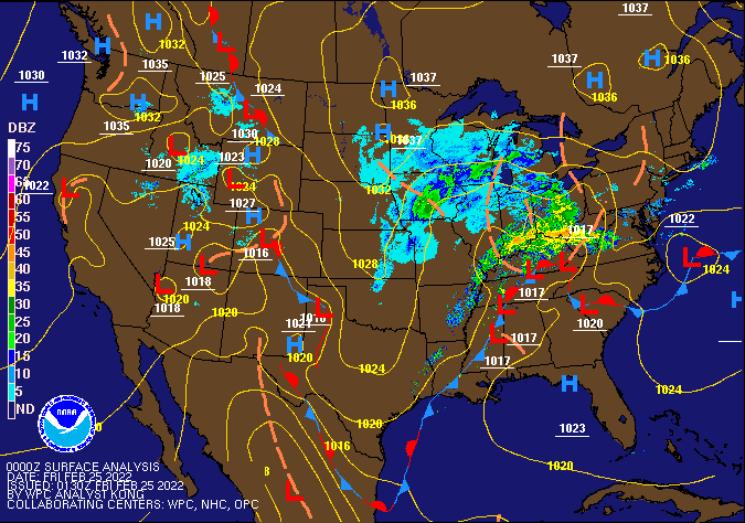 Weather Prediction Center Surface Analysis/Fronts/Radar 6pm Thursday |
Snow/Rain Maps
| Local Snowfall Map | Regional Snow Map (courtesy IEM) | Local Snow Analysis (courtesy IEM) |
 |
 |
 |
| Local Liquid Equivalent Map | ||
.png) |
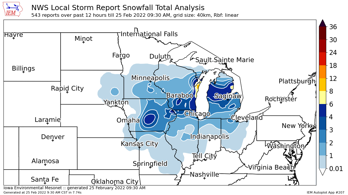
Storm Reports
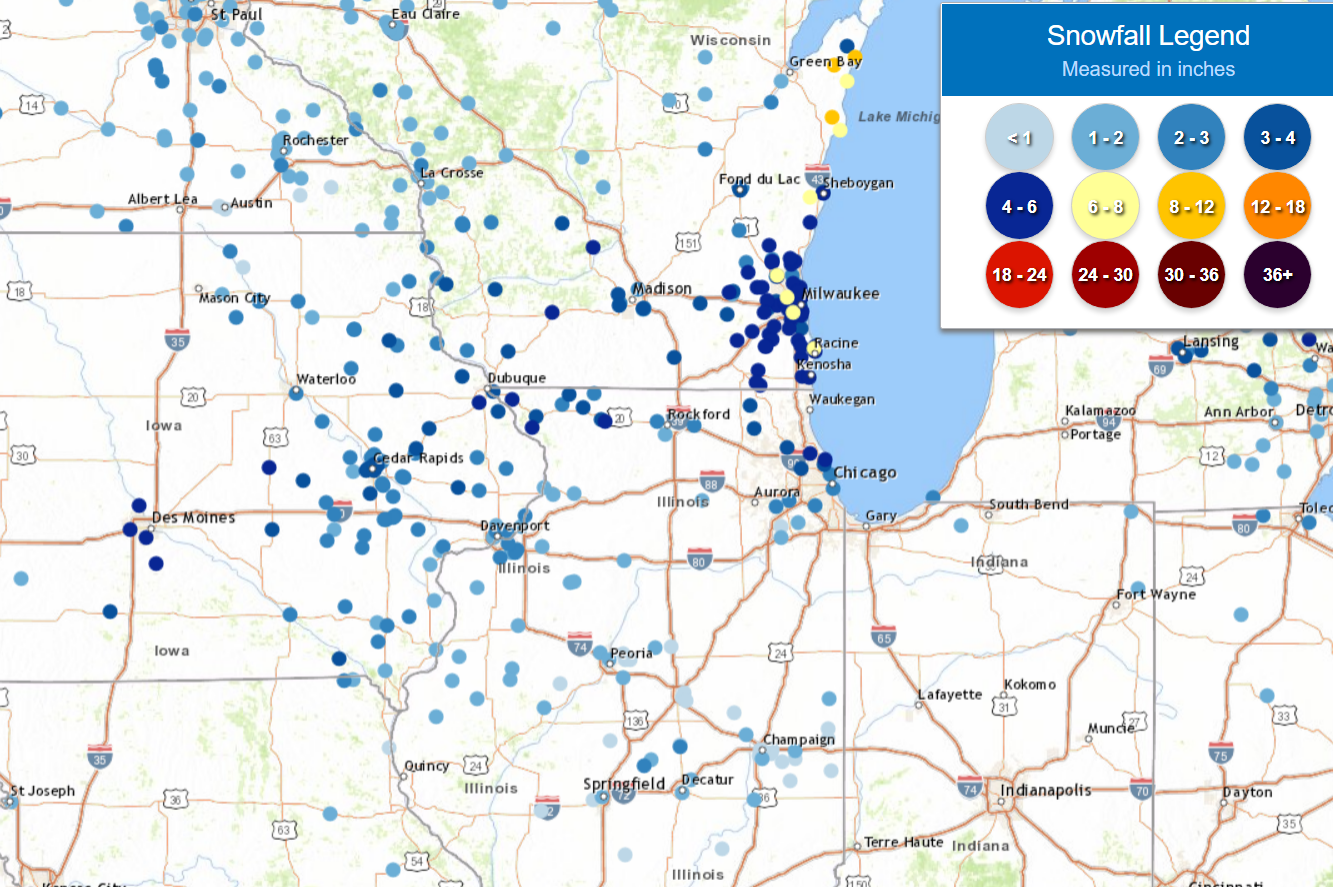
Storm Reports Map - Courtesy IEM
 |
PRELIMINARY LOCAL STORM REPORT...SUMMARY
NATIONAL WEATHER SERVICE QUAD CITIES IA IL
827 AM CST FRI FEB 25 2022
..TIME... ...EVENT... ...CITY LOCATION... ...LAT.LON...
..DATE... ....MAG.... ..COUNTY LOCATION..ST.. ...SOURCE....
..REMARKS..
0631 AM SNOW 1 NW DUBUQUE REGIONAL A 42.41N 90.73W
02/25/2022 M5.5 INCH DUBUQUE IA OFFICIAL NWS OBS
STORM TOTAL, 0.3 SNOW AFTER MIDNIGHT.
0748 AM SNOW HANOVER 42.25N 90.27W
02/25/2022 M5.0 INCH JO DAVIESS IL TRAINED SPOTTER
STORM TOTAL.
0800 AM SNOW 1 NW GALENA 42.43N 90.44W
02/25/2022 M4.0 INCH JO DAVIESS IL TRAINED SPOTTER
0742 AM SNOW LOWDEN 41.86N 90.92W
02/25/2022 M3.7 INCH CEDAR IA CO-OP OBSERVER
STORM TOTAL.
0429 AM SNOW 3 NNE CEDAR RAPIDS 42.01N 91.66W
02/25/2022 E3.5 INCH LINN IA TRAINED SPOTTER
0600 AM SNOW 3 NE CEDAR RAPIDS 42.00N 91.63W
02/25/2022 M3.5 INCH LINN IA COCORAHS
COCORAHS STATION IA-LN-31 CEDAR RAPIDS 2.7
NE.
0700 AM SNOW 2 SE EAST DUBUQUE 42.48N 90.61W
02/25/2022 M3.5 INCH JO DAVIESS IL COCORAHS
COCORAHS STATION IL-JD-11 EAST DUBUQUE 1.7
SE.
0747 AM SNOW 2 SW SAINT DONATUS 42.35N 90.57W
02/25/2022 M3.5 INCH JACKSON IA TRAINED SPOTTER
0800 AM SNOW 1 NNW MONTICELLO MUNICI 42.24N 91.17W
02/25/2022 M3.5 INCH JONES IA CO-OP OBSERVER
CO-OP OBSERVER STATION MCLI4 MONTICELLO.
0636 AM SNOW 2 WNW FREEPORT 42.30N 89.66W
02/25/2022 E3.3 INCH STEPHENSON IL TRAINED SPOTTER
0537 AM SNOW MANCHESTER 42.49N 91.46W
02/25/2022 M3.2 INCH DELAWARE IA TRAINED SPOTTER
STORM TOTAL, RELAYED BY BROADCAST MEDIA.
0510 AM SNOW ANAMOSA 42.11N 91.29W
02/25/2022 M3.1 INCH JONES IA TRAINED SPOTTER
STORM TOTAL.
0630 AM SNOW ELIZABETH 42.32N 90.23W
02/25/2022 M3.1 INCH JO DAVIESS IL CO-OP OBSERVER
CO-OP OBSERVER STATION EZBI2 ELIZABETH.
0710 AM SNOW RICKARDSVILLE 42.58N 90.88W
02/25/2022 M3.1 INCH DUBUQUE IA TRAINED SPOTTER
0700 AM SNOW KEOSAUQUA 40.73N 91.96W
02/25/2022 M3.0 INCH VAN BUREN IA MESONET
MESONET STATION KEQI4 KEOSAUQUA.
0700 AM SNOW 1 WNW COU FALLS 41.82N 91.69W
02/25/2022 M3.0 INCH JOHNSON IA TRAINED SPOTTER
0706 AM SNOW NORA 42.46N 89.94W
02/25/2022 M3.0 INCH JO DAVIESS IL TRAINED SPOTTER
0731 AM SNOW 3 W CEDAR RAPIDS 41.97N 91.73W
02/25/2022 M3.0 INCH LINN IA TRAINED SPOTTER
STORM TOTAL.
0742 AM SNOW LENA 42.38N 89.82W
02/25/2022 M3.0 INCH STEPHENSON IL PUBLIC
0600 AM SNOW 3 NE CEDAR RAPIDS 42.00N 91.64W
02/25/2022 M2.9 INCH LINN IA TRAINED SPOTTER
0315 AM SNOW MARION 42.03N 91.59W
02/25/2022 M2.8 INCH LINN IA BROADCAST MEDIA
EVENT TOTAL.
0335 AM SNOW HIAWATHA 42.05N 91.68W
02/25/2022 M2.8 INCH LINN IA TRAINED SPOTTER
EVENT TOTAL.
0711 AM SNOW 1 ENE MOUNT VERNON 41.93N 91.41W
02/25/2022 E2.8 INCH LINN IA TRAINED SPOTTER
0725 AM SNOW 3 N STOCKTON 42.40N 90.00W
02/25/2022 M2.8 INCH JO DAVIESS IL CO-OP OBSERVER
LIQUID EQUIVALENT 0.15.
0700 AM SNOW 2 NE CALAMUS 41.84N 90.73W
02/25/2022 M2.7 INCH CLINTON IA COCORAHS
COCORAHS STATION IA-CN-2 CALAMUS 2.0 NE.
0700 AM SNOW 3 NNE MC CONNELL 42.47N 89.72W
02/25/2022 M2.7 INCH STEPHENSON IL COCORAHS
COCORAHS STATION IL-SP-8 WINSLOW 4.3 ESE.
0741 AM SNOW 1 SW UNIVERSITY HEIGHTS 41.65N 91.57W
02/25/2022 M2.7 INCH JOHNSON IA TRAINED SPOTTER
0615 AM SNOW 3 W RICHMOND 41.46N 91.76W
02/25/2022 M2.6 INCH WASHINGTON IA COCORAHS
COCORAHS STATION IA-WS-7 WELLMAN 4.0 E.
0600 AM SNOW 2 ESE FAIRVIEW 42.08N 91.30W
02/25/2022 M2.5 INCH JONES IA CO-OP OBSERVER
CO-OP OBSERVER STATION AMOI4 ANAMOSA 3 SSW.
0600 AM SNOW ELY 41.87N 91.58W
02/25/2022 M2.5 INCH LINN IA COCORAHS
COCORAHS STATION IA-LN-3 ELY 0.5 SE.
0630 AM SNOW ELY 41.88N 91.59W
02/25/2022 M2.5 INCH LINN IA TRAINED SPOTTER
EVENT SNOW TOTAL, RELAYED BY BROADCAST
MEDIA.
0644 AM SNOW 1 SW PERLEE 41.07N 91.91W
02/25/2022 M2.5 INCH JEFFERSON IA TRAINED SPOTTER
0700 AM SNOW 3 S SHELLSBURG 42.05N 91.87W
02/25/2022 M2.5 INCH BENTON IA COCORAHS
COCORAHS STATION IA-BT-16 SHELLSBURG 2.9 S.
0700 AM SNOW 2 E IOWA CITY 41.66N 91.49W
02/25/2022 M2.5 INCH JOHNSON IA COCORAHS
COCORAHS STATION IA-JH-34 IOWA CITY 2.3 E.
0700 AM SNOW LISBON 41.92N 91.39W
02/25/2022 M2.5 INCH LINN IA COCORAHS
COCORAHS STATION IA-LN-56 LISBON 0.1 W.
0700 AM SNOW 1 NNW WEST LIBERTY 41.58N 91.27W
02/25/2022 M2.5 INCH MUSCATINE IA COCORAHS
COCORAHS STATION IA-MC-15 WEST LIBERTY 0.7
NNW.
0710 AM SNOW SOLON 41.80N 91.49W
02/25/2022 M2.5 INCH JOHNSON IA TRAINED SPOTTER
0728 AM SNOW 4 ENE IOWA CITY 41.67N 91.47W
02/25/2022 M2.5 INCH JOHNSON IA TRAINED SPOTTER
0749 AM SNOW 1 W CHARLIE HEATH MEMOR 40.58N 91.92W
02/25/2022 M2.5 INCH CLARK MO TRAINED SPOTTER
0630 AM SNOW 2 ENE HIAWATHA 42.05N 91.64W
02/25/2022 M2.4 INCH LINN IA TRAINED SPOTTER
0728 AM SNOW 1 W IOWA CITY 41.65N 91.55W
02/25/2022 M2.4 INCH JOHNSON IA TRAINED SPOTTER
0330 AM SNOW 1 NNE MOLINE 41.49N 90.48W
02/25/2022 M2.3 INCH ROCK ISLAND IL NWS EMPLOYEE
STORM TOTAL.
0700 AM SNOW 1 SE ROBINS 42.07N 91.66W
02/25/2022 M2.3 INCH LINN IA COCORAHS
COCORAHS STATION IA-LN-53 ROBINS 0.8 SE.
0700 AM SNOW 1 NNE MOLINE 41.49N 90.48W
02/25/2022 M2.3 INCH ROCK ISLAND IL COCORAHS
COCORAHS STATION IL-RI-13 MOLINE 0.7 NNE.
0710 AM SNOW 1 W MAQUOKETA MUNICIPAL 42.05N 90.75W
02/25/2022 M2.3 INCH JACKSON IA CO-OP OBSERVER
CO-OP OBSERVER STATION MKTI4 MAQUOKETA.
0700 AM SNOW 2 WNW CHARLOTTE 41.98N 90.50W
02/25/2022 M2.2 INCH CLINTON IA COCORAHS
COCORAHS STATION IA-CN-17 CHARLOTTE 1.9 WNW.
0700 AM SNOW 4 NNE LAFAYETTE 42.20N 91.65W
02/25/2022 M2.2 INCH LINN IA COCORAHS
COCORAHS STATION IA-LN-7 CENTRAL CITY 6.7 W.
0630 AM SNOW 3 SW QUAD CITY AIRPORT 41.40N 90.55W
02/25/2022 M2.1 INCH ROCK ISLAND IL OFFICIAL NWS OBS
STORM TOTAL, 0.2 SNOW AFTER MIDNIGHT.
0650 AM SNOW 1 N WILLIAMSBURG 41.68N 92.01W
02/25/2022 M2.1 INCH IOWA IA TRAINED SPOTTER
0713 AM SNOW 2 W BETTENDORF 41.57N 90.51W
02/25/2022 M2.1 INCH SCOTT IA NWS EMPLOYEE
0730 AM SNOW 2 W BETTENDORF 41.56N 90.51W
02/25/2022 M2.1 INCH SCOTT IA COCORAHS
COCORAHS STATION IA-ST-48 BETTENDORF 1.6 W.
0525 AM SNOW NORTH ENGLISH 41.51N 92.07W
02/25/2022 E2.0 INCH IOWA IA TRAINED SPOTTER
0600 AM SNOW 2 NNW MOUNT AUBURN 42.29N 92.11W
02/25/2022 M2.0 INCH BENTON IA COCORAHS
COCORAHS STATION IA-BT-11 MOUNT AUBURN 2.2
NNW.
0600 AM SNOW 3 SSW MARENGO 41.76N 92.08W
02/25/2022 M2.0 INCH IOWA IA COCORAHS
COCORAHS STATION IA-IA-2 MARENGO 2.6 SSW.
0700 AM SNOW 2 SW YARMOUTH 41.01N 91.35W
02/25/2022 M2.0 INCH DES MOINES IA COCORAHS
COCORAHS STATION IA-DM-15 2 WSW YARMOUTH.
0700 AM SNOW 2 NNW WARNER 41.45N 90.40W
02/25/2022 M2.0 INCH HENRY IL COCORAHS
COCORAHS STATION IL-HY-15 COAL VALLEY 2.6 E.
0700 AM SNOW 2 SE COAL VALLEY 41.43N 90.42W
02/25/2022 M2.0 INCH HENRY IL COCORAHS
COCORAHS STATION IL-HY-5 COAL VALLEY 1.9 SE.
0700 AM SNOW 4 NNE MUSCATINE 41.47N 91.05W
02/25/2022 M2.0 INCH MUSCATINE IA CO-OP OBSERVER
CO-OP OBSERVER STATION MSTI4 2 N MUSCATINE.
0700 AM SNOW NORTH ENGLISH 41.51N 92.07W
02/25/2022 M2.0 INCH IOWA IA CO-OP OBSERVER
CO-OP OBSERVER STATION NENI4 NORTH ENGLISH.
0700 AM SNOW 1 S SALEM 40.84N 91.62W
02/25/2022 M2.0 INCH HENRY IA CO-OP OBSERVER
CO-OP OBSERVER STATION SLHI4 SALEM 1 S.
0733 AM SNOW 1 W BETTENDORF 41.56N 90.49W
02/25/2022 E2.0 INCH SCOTT IA TRAINED SPOTTER
0800 AM SNOW 1 WSW MOUNT PLEASANT MU 40.95N 91.54W
02/25/2022 M2.0 INCH HENRY IA TRAINED SPOTTER
0439 AM SNOW DAVENPORT AIRPORT 41.61N 90.58W
02/25/2022 M1.9 INCH SCOTT IA OFFICIAL NWS OBS
STORM TOTAL, 0.1 SNOW FELL AFTER MIDNIGHT.
0630 AM SNOW DAVENPORT AIRPORT 41.61N 90.58W
02/25/2022 M1.9 INCH SCOTT IA OFFICIAL NWS OBS
STORM TOTAL, 0.1 SNOW AFTER MIDNIGHT.
0633 AM SNOW 1 SE DAVENPORT 41.54N 90.59W
02/25/2022 M1.9 INCH SCOTT IA COCORAHS
COCORAHS STATION IA-ST-37 DAVENPORT 0.9 WNW.
0700 AM SNOW 3 SSW MALVERN 41.82N 89.90W
02/25/2022 M1.9 INCH WHITESIDE IL COCORAHS
COCORAHS STATION IL-WD-5 MORRISON 3.2 E.
0700 AM SNOW DONNELLSON 40.65N 91.56W
02/25/2022 M1.9 INCH LEE IA CO-OP OBSERVER
CO-OP OBSERVER STATION DNNI4 DONNELLSON.
0700 AM SNOW 3 SSE ATKINS 41.96N 91.84W
02/25/2022 M1.9 INCH BENTON IA COCORAHS
COCORAHS STATION IA-BT-12 FAIRFAX 4.0 NW.
0515 AM SNOW PARNELL 41.58N 92.01W
02/25/2022 M1.8 INCH IOWA IA TRAINED SPOTTER
EVENT SNOW TOTAL.
0724 AM SNOW 2 S DAVENPORT 41.53N 90.61W
02/25/2022 M1.8 INCH SCOTT IA TRAINED SPOTTER
0749 AM SNOW 2 NNW OAKLAND MILLS 40.97N 91.63W
02/25/2022 M1.8 INCH HENRY IA TRAINED SPOTTER
STORM TOTAL.
0630 AM SNOW 2 NW GENESEO 41.47N 90.18W
02/25/2022 M1.7 INCH HENRY IL COCORAHS
COCORAHS STATION IL-HY-8 GENESEO 2.0 NW.
0700 AM SNOW 3 ESE AMBER 41.11N 91.13W
02/25/2022 M1.7 INCH LOUISA IA COCORAHS
COCORAHS STATION IA-LS-5 WAPELLO 5.4 SE.
0700 AM SNOW 1 E KEWANEE 41.24N 89.90W
02/25/2022 M1.6 INCH HENRY IL CO-OP OBSERVER
CO-OP OBSERVER STATION KEWI2 KEWANEE 1 E.
0600 AM SNOW 2 S PRAIRIE CITY 40.59N 90.46W
02/25/2022 M1.5 INCH MCDONOUGH IL CO-OP OBSERVER
CO-OP OBSERVER STATION PRCI2 2.0 S PRAIRIE
CITY.
0650 AM SNOW 1 NE LE CLAIRE 41.60N 90.36W
02/25/2022 M1.5 INCH SCOTT IA PUBLIC
0700 AM SNOW BENTLEY 40.34N 91.11W
02/25/2022 M1.5 INCH HANCOCK IL CO-OP OBSERVER
CO-OP OBSERVER STATION BTYI2 BENTLEY.
0711 AM SNOW 1 SSW COAL VALLEY 41.43N 90.45W
02/25/2022 M1.5 INCH ROCK ISLAND IL TRAINED SPOTTER
0711 AM SNOW 1 SSW KEWANEE 41.23N 89.93W
02/25/2022 M1.5 INCH HENRY IL TRAINED SPOTTER
0729 AM SNOW 2 NNW MUSCATINE 41.44N 91.08W
02/25/2022 E1.5 INCH MUSCATINE IA TRAINED SPOTTER
0739 AM SNOW 1 SSW MUSCATINE MUNICIP 41.35N 91.16W
02/25/2022 M1.5 INCH MUSCATINE IA TRAINED SPOTTER
0700 AM SNOW PRINCETON 41.38N 89.46W
02/25/2022 M1.4 INCH BUREAU IL CO-OP OBSERVER
CO-OP OBSERVER STATION PTNI2 PRINCETON.
0700 AM SNOW ALEDO 41.20N 90.75W
02/25/2022 M1.2 INCH MERCER IL CO-OP OBSERVER
CO-OP OBSERVER STATION ALEI2 ALEDO.
0700 AM SNOW 1 SW STRONGHURST 40.74N 90.91W
02/25/2022 M1.2 INCH HENDERSON IL COCORAHS
COCORAHS STATION IL-HD-1 STRONGHURST 0.4
SSW.
0700 AM SNOW 3 W MACOMB 40.46N 90.75W
02/25/2022 M1.0 INCH MCDONOUGH IL COCORAHS
COCORAHS STATION IL-MCD-7 COLCHESTER 3.5 NE.
0700 AM SNOW LA HARPE 40.58N 90.97W
02/25/2022 M1.0 INCH HANCOCK IL CO-OP OBSERVER
CO-OP OBSERVER STATION LAHI2 LA HARPE.
 |
Media use of NWS Web News Stories is encouraged! Please acknowledge the NWS as the source of any news information accessed from this site. |
|