Scattered severe thunderstorms capable of damaging wind gusts and some hail are expected this afternoon and evening from the Upper Ohio River Valley into the Northeast, and from the Appalachians into the Mid-Atlantic States. Excessive rainfall from heavy thunderstorms may produce areas of flash flooding from southern New Mexico into the western and northern Gulf Coast into Wednesday. Read More >
|
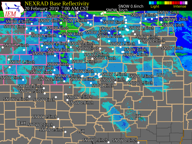
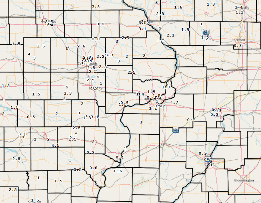
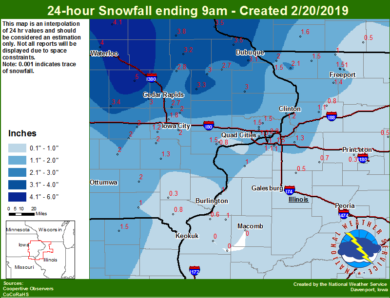
An area of low pressure developed over eastern Kansas and tracked north across Iowa Tuesday night and Wednesday bringing snow and freezing rain/drizzle to eastern Iowa, northeast Missouri and northwest Illinois. Snowfall totals between 1 and 4 inches fell across much of the forecast area, with the higher amounts up to 5 inches occurring further north and west. Precipitation changed over to freezing rain/drizzle around 6 am Wednesday causing slick road conditions.
|
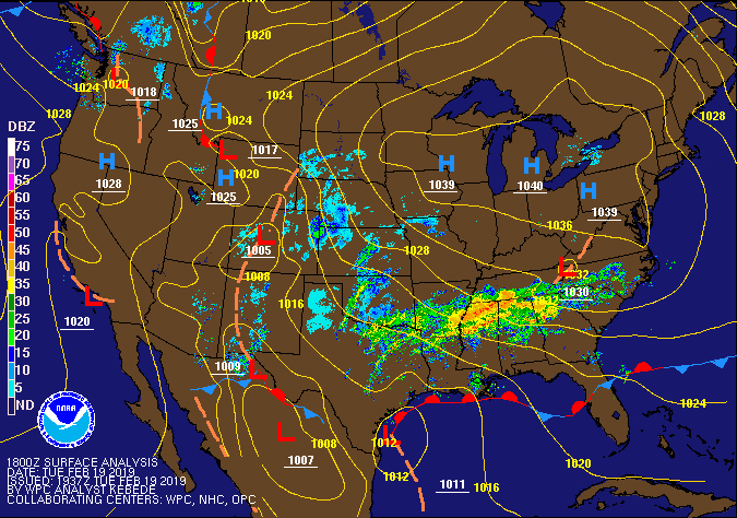 WPC Surface Map & Radar Loop |
Snow/Ice
| Local Snowfall Map Feb. 20 |
Regional Snowfall Map Feb. 20 |
 |
.png) |
Wednesday February 20, 2019.

....IOWA....
Vinton                            5.0
Boone 1 SSW                       4.6
Cresco 1 NE                       4.2
Tripoli 0 N                       4.1
Rathbun Reservoir 2 N             4.0
Mason City 1 NNE                  4.0
Fayette 1 NW                      4.0
Waterloo ASOS 5 NW                4.0
Strawberry Point                  3.8
Rickardsville 0.2 W               3.5
Perry 0 W                         3.5
Guttenberg Dam 10                 3.5
Belle Plaine                      3.4
Anamosa 3 SSW                     3.3
Manchester                        3.2
Dubuque Arpt 7 SW                 3.1
Fairfax 4.0 NW                    3.0
Beaconsfield 1 NNE                3.0
Marshalltown 1 NW                 3.0
Maquoketa 4 W                     3.0
Toledo 3 N                        3.0
Monticello 1 E                    3.0
Coggon                            2.8
Cascade                           2.7
Ely 0.5 SE                        2.7
Riverdale 0.5 N                   2.2
Centerville 0 NE                  2.2
NWS Johnston* 5 NNW               2.1
North English                     2.0
Iowa City                         2.0
Wellman 4.0 E                     2.0
Sigourney                         2.0
Fairfield                         2.0
Williamsburg                      2.0
Solon 0.3 ESE                     2.0
North Liberty 0.7 SSW             1.8
Bettendorf 2.2 SE                 1.5
Davenport Arpt 5 N                1.5
Eldridge 0.7 SSW                  1.5
Muscatine 2.1 N                   1.5
Bellevue LD12                     1.5
Park View 0.2 WSW                 1.5
Washington                        1.3
Davenport 0.9 SSW                 1.3
Camanche 1.2 W                    1.2
Kalona 7.3 NNW                    1.2
Keosauqua                         1.0
Muscatine 2N                      0.8
Donnellson                        0.8
Davenport 0.9 WNW                 0.6
Oskaloosa 1 NNW                   0.5
Burlington 2S                     0.4
Salem 1S                          0.3
....ILLINOIS....
Elizabeth                         2.1
Galena                            2.0
Freeport 2.0 NW                   1.5
Coal Valley 2.6 E                 1.5
Stockton 3.4 NNE                  1.5
Shannon 0.2 S                     1.4
Geneseo 2.0 NW                    1.3
Quad City Arpt 3 S                1.1
Morrison 3.2 E                    1.1
Freeport 1.7 NW                   1.1
Aledo                             1.0
La Harpe                          1.0
Gladstone LD18                    1.0
Freeport                          1.0
Moline 0.7 NNE                    1.0
Coal Valley 1.9 SE                1.0
Winslow 4.3 ESE                   1.0
Rockford ASOS                     0.8
Coleta 1.4 SSW                    0.8
St Anne                           0.8
Kewanee 1 E                       0.7
Dallas City 3.0 SSE               0.6
Rochelle                          0.6
Steward                           0.5
Mendota 2 SE                      0.5
Altona                            0.5
Roscoe 2SE                        0.4
Princeton 1.1 SE                  0.3
Tiskilwa 2.1 N                    0.3
Romeoville                        0.3
Princeton                         0.3
Mundelein                         0.2
Ogden                             0.2
Windsor                           0.0
Ottawa 4 SW                       0.0
Bentley                           0.0
Augusta                           0.0
Colchester 3.5 NE                 0.0
Streator 3 SE                     0.0
Tuscola                           0.0
....MISSOURI....
Memphis                           1.5
Columbia                          0.5
....WISCONSIN....
Steuben 4SE 3 NE                  4.0
Viroqua                           3.5
La Crosse WFO                     2.0
Darlington                        1.6
Madison-ASOS                      1.5
Beloit-College                    1.0
Whitewater                        0.9
Delavan-1 W-WWTP 1 W              0.5
Brodhead 1 SW                     0.5
....MINNESOTA....
Preston                           3.8
Theilman 1SSW                     2.4
|
Storm Reports Map - Courtesy IEM
|
MAP BELOW AS OF 10 AM 2/20/2019 |
PRELIMINARY LOCAL STORM REPORT...SUMMARY
NATIONAL WEATHER SERVICE QUAD CITIES IA IL
1030 AM CST WED FEB 20 2019
THE REPORTS BELOW ARE SEPARATED INTO SNOW AND ICE AND THEN BY AMOUNT. THEY ARE NOT NECESSARILY THE FINAL AMOUNT FOR EACH LOCATION. SNOW REPORTS LISTED BY AMOUNT INCHES LOCATION ST COUNTY TIME ------ ----------------------- -- -------------- ------- 5.0 1 SE VINTON IA BENTON 0923 AM 5.0 1 E VINTON IA BENTON 0700 AM 4.8 4 NNW ELY IA LINN 0916 AM 4.1 2 W MARION IA LINN 0819 AM 4.1 DUBUQUE REGIONAL ARPT IA DUBUQUE 1200 PM 3.5 1 NW CENTER GROVE IA DUBUQUE 0824 AM 3.5 DUBUQUE IA DUBUQUE 0524 AM 3.4 2 NNE CEDAR RAPIDS IA LINN 0856 AM 3.3 PARNELL IA IOWA 0841 AM 3.3 2 ESE FAIRVIEW IA JONES 0600 AM 3.2 1 SSE MANCHESTER IA DELAWARE 0700 AM 3.1 AINSWORTH IA WASHINGTON 0818 AM 3.0 WAYLAND IA HENRY 0941 AM 3.0 WEST CHESTER IA WASHINGTON 0851 AM 3.0 1 W WASHINGTON IA WASHINGTON 0812 AM 3.0 1 NNW MONTICELLO MUNICI IA JONES 0721 AM 3.0 2 W MAQUOKETA IA JACKSON 0700 AM 3.0 OLIN IA JONES 0601 AM 2.8 COGGON IA LINN 0500 AM 2.8 HIAWATHA IA LINN 0422 AM 2.7 CASCADE IA DUBUQUE 0700 AM 2.7 ELY IA LINN 0530 AM 2.7 2 SSW HIAWATHA IA LINN 0410 AM 2.6 1 NNW CENTER POINT IA LINN 0600 AM 2.5 2 NNW NORTH LIBERTY IA JOHNSON 0929 AM 2.5 PLEASANT PLAIN IA JEFFERSON 0827 AM 2.5 LOWDEN IA CEDAR 0720 AM 2.5 PARNELL IA IOWA 0534 AM 2.3 1 ENE MOUNT VERNON IA LINN 0815 AM 2.2 SPRINGVILLE IA LINN 0700 AM 2.2 1 N RIVERDALE IA SCOTT 0700 AM 2.1 2 NW ELIZABETH IL JO DAVIESS 0630 AM 2.0 1 NNE FAIRFIELD IA JEFFERSON 0814 AM 2.0 FREEPORT IL STEPHENSON 0813 AM 2.0 WYOMING IA JONES 0810 AM 2.0 SIGOURNEY IA KEOKUK 0800 AM 2.0 1 WNW MOUNT PLEASANT IA HENRY 0722 AM 2.0 WILLIAMSBURG IA IOWA 0700 AM 2.0 1 E NORTH ENGLISH IA IOWA 0700 AM 2.0 1 S IOWA CITY IA JOHNSON 0700 AM 2.0 SOLON IA JOHNSON 0700 AM 2.0 GALENA IL JO DAVIESS 0700 AM 2.0 3 W RICHMOND IA WASHINGTON 0630 AM 2.0 2 W MARION IA LINN 1259 AM 1.8 1 SSW CORDOVA IL ROCK ISLAND 0825 AM 1.6 UNIVERSITY HEIGHTS IA JOHNSON 0859 AM 1.5 1 W BETTENDORF IA SCOTT 0854 AM 1.5 3 N STOCKTON IL JO DAVIESS 0730 AM 1.5 3 NNE STOCKTON IL JO DAVIESS 0700 AM 1.5 2 NNW WARNER IL HENRY 0700 AM 1.5 2 N MUSCATINE IA MUSCATINE 0700 AM 1.5 2 NW FREEPORT IL STEPHENSON 0630 AM 1.5 DAVENPORT AIRPORT IA SCOTT 0600 AM 1.5 MEMPHIS MO SCOTLAND 0600 AM 1.5 5 S RICE IL JO DAVIESS 0600 AM 1.5 1 SW PERLEE IA JEFFERSON 0531 AM 1.5 1 E IOWA CITY IA JOHNSON 0526 AM 1.5 2 ESE FAIRFIELD IA JEFFERSON 0449 AM 1.4 1 S WALCOTT IA SCOTT 0844 AM 1.3 1 W WASHINGTON AIRPORT IA WASHINGTON 0700 AM 1.3 2 NW GENESEO IL HENRY 0500 AM 1.1 2 NW FREEPORT IL STEPHENSON 0650 AM 1.1 MOLINE QUAD-CITY AIRPOR IL ROCK ISLAND 0612 AM 1.1 2 W MARION IA LINN 0959 PM 1.1 2 W CEDAR RAPIDS IA LINN 0952 PM 1.0 KEOSAUQUA IA VAN BUREN 0700 AM 1.0 3 NNE MC CONNELL IL STEPHENSON 0700 AM 1.0 1 NNE MOLINE IL ROCK ISLAND 0700 AM 1.0 1 NE FREEPORT IL STEPHENSON 0700 AM 1.0 1 N ALEDO IL MERCER 0700 AM 1.0 1 N ALEDO IL MERCER 0700 AM 1.0 1 W ELMIRA IA JOHNSON 0645 AM 1.0 7 S KINGSTON IA DES MOINES 0600 AM 0.8 COAL VALLEY IL ROCK ISLAND 0700 AM 0.8 4 NNE MUSCATINE IA MUSCATINE 0700 AM 0.8 1 S DONNELLSON IA LEE 0700 AM 0.7 1 ENE KEWANEE IL HENRY 0700 AM 0.6 1 SE DAVENPORT IA SCOTT 0646 AM 0.6 2 NNE COLUSA IL HANCOCK 0630 AM 0.5 3 ENE CHARLIE HEATH MEM MO CLARK 0925 AM 0.5 2 NE COLUSA IL HANCOCK 0630 AM 0.5 3 ESE HIAWATHA IA LINN 0908 PM 0.4 1 ESE BURLINGTON REGION IA DES MOINES 0500 AM 0.3 1 S SALEM IA HENRY 0700 AM 0.3 1 WNW PRINCETON IL BUREAU 0700 AM 0.3 2 N TISKILWA IL BUREAU 0700 AM 0.3 1 SE PRINCETON IL BUREAU 0700 AM SLEET AND FREEZING RAIN REPORTS LISTED BY AMOUNT INCHES LOCATION ST COUNTY TIME ------ ----------------------- -- -------------- ------- 0.2 1 W LOMBARDVILLE IL BUREAU 0935 AM 0.1 1 S SALEM IA HENRY 0800 AM 0.0 CEDARVILLE IL STEPHENSON 0852 AM |
Environment
| Davenport, IA Sounding 6 PM 02/19/2019 |
Davenport, IA Sounding 6 AM 02/20/2019 |
 |
 |
 |
Media use of NWS Web News Stories is encouraged! Please acknowledge the NWS as the source of any news information accessed from this site. |
|