Overview
|
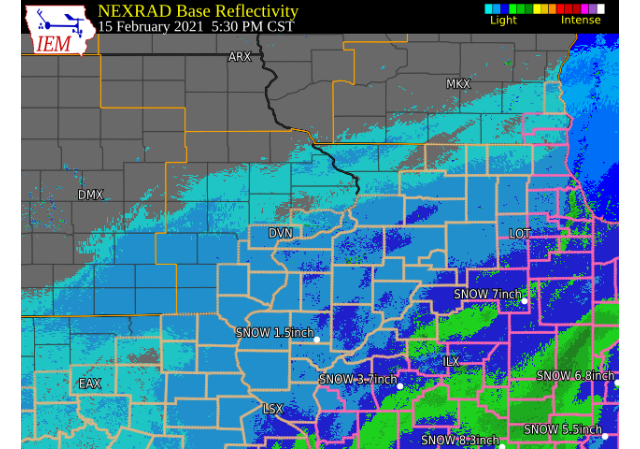
February 15, 2021 An area of light to moderate snow moved north across extreme eastern Iowa, Missouri, and Illinois Monday, February 15, 2021. North winds of 10 to 15 mph brought some blowing and drifting snow on east-west roads. Snowfall amounts were generally between 1 and 3 inches along and south of a Fairfield, IA to Freeport, IL line. The higher amounts around 3-4 inches fell in west central and north central IL. Official National Weather Service Observations
|
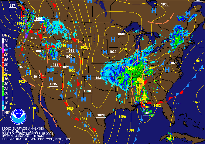 WPC - Surface Map and Radar Loop |
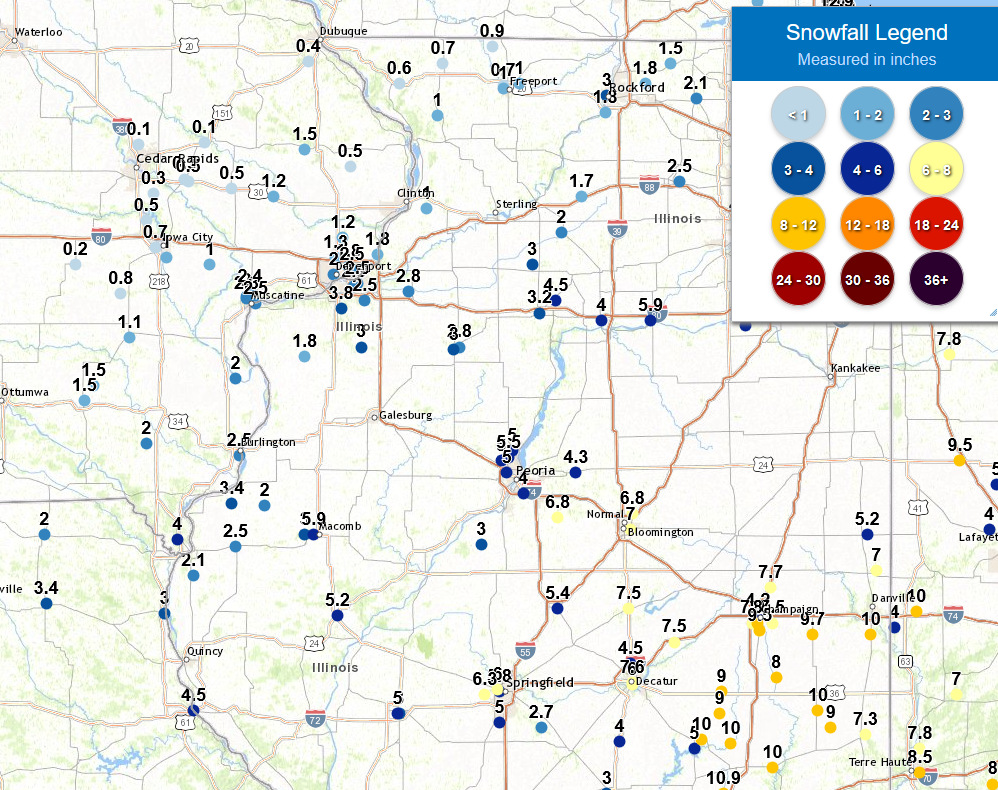
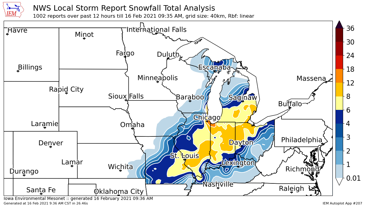
Snowfall Amounts
| Local Snowfall Ending 9 AM TUESDAY 2/16 | Regional Snowfall |
 |
 |
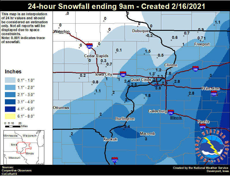
24 hour snow fall in inches,
for eastern Iowa, northwest and west central Illinois,
and northeast Missouri. Reported between Midnight and 9 AM,
Sunday February 07, 2021.
....IOWA....
Muscatine 2N                      2.4
Bettendorf 1.6 W                  2.3
Muscatine 2.1 N                   2.0
Wapello 5.4 SE                    2.0
Davenport 0.9 WNW                 2.0
Salem 1S                          2.0
Columbus Jct 2 SSW                2.0
Le Claire 1.8 NNE                 1.8
Maquoketa                         1.5
Davenport Arpt                    1.3
Park View 0.2 WSW                 1.2
Washington                        1.1
Iowa City                         1.0
West Liberty 0.7 NNW              1.0
Wellman 4.0 E                     0.8
Solon 0.3 ESE                     0.7
Centerville 0 NE                  0.5
Charlotte 1.9 WNW                 0.5
Oskaloosa 1 NNW                   0.5
Ely 0.5 SE                        0.3
Dubuque Arpt                      0.3
Parnell 0.1 SSW                   0.2
Anamosa 3 SSW                     0.1

....ILLINOIS....
Windsor                           7.0
Romeoville                        7.0
Ogden                             7.0
Tuscola                           7.0
Quad City Arpt                    3.8
Mundelein                         3.6
Dallas City 3.0 SSE               3.4
Princeton 1.1 SE                  3.2
Princeton                         3.2
Rockford ASOS                     3.0
Colchester 3.5 NE                 3.0
Walnut 5.3 ENE                    3.0
Kewanee 1 E                       2.8
Geneseo 2.0 NW                    2.8
Moline 0.7 NNE                    2.5
Coal Valley 1.9 SE                2.5
Ill. City LD16 3 WNW              2.5
Gladstone LD18                    2.0
Aledo                             1.8
Freeport 1.7 NW                   1.5
Jacksonville 2E                   1.5
Freeport                          1.0
Mount Carroll 6.8 NNW             1.0
Winslow 4.3 ESE                   0.9
Freeport 2.0 NW                   0.7
Stockton 3.4 NNE                  0.7
Elizabeth                         0.6

....MISSOURI....
Memphis                           2.0
Columbia                          1.3
|
Storm Reports
February 15th Storm Reports
Courtesy IEM
|
|
PRELIMINARY LOCAL STORM REPORT...SUMMARY
NATIONAL WEATHER SERVICE QUAD CITIES IA IL
1012 AM CST TUE FEB 16 2021

..TIME...   ...EVENT...      ...CITY LOCATION...     ...LAT.LON...
..DATE...   ....MAG....      ..COUNTY LOCATION..ST.. ...SOURCE....
            ..REMARKS..

0706 AM     SNOW             MALDEN                  41.43N 89.37W
02/16/2021  E4.5 INCH        BUREAU             IL   PUBLIC

            OVERNIGHT TOTAL.

0402 AM     SNOW             1 SSW MOOAR             40.44N 91.45W
02/16/2021  M4.0 INCH        LEE                IA   TRAINED SPOTTER

            STORM TOTAL.

0638 AM     SNOW             3 SW QUAD CITY AIRPORT  41.40N 90.55W
02/16/2021  M3.8 INCH        ROCK ISLAND        IL   OFFICIAL NWS OBS

            STORM TOTAL; 0.3 INCHES SINCE MIDNIGHT.

0600 AM     SNOW             2 NE COLUSA             40.59N 91.15W
02/16/2021  E3.4 INCH        HANCOCK            IL   PUBLIC


0700 AM     SNOW             PRINCETON               41.38N 89.46W
02/16/2021  M3.2 INCH        BUREAU             IL   CO-OP OBSERVER

            CO-OP OBSERVER STATION PTNI2 PRINCETON.

0750 AM     SNOW             1 SSW KEWANEE           41.23N 89.93W
02/16/2021  E3.0 INCH        HENRY              IL   TRAINED SPOTTER

            STORM TOTAL ESTIMATED DUE TO DRIFTING.

0727 AM     SNOW             2 E GRIFFIN             41.24N 90.44W
02/16/2021  M3.0 INCH        HENRY              IL   TRAINED SPOTTER

            STORM TOTAL.

0700 AM     SNOW             3 NW OHIO               41.58N 89.50W
02/16/2021  M3.0 INCH        BUREAU             IL   COCORAHS

            COCORAHS STATION IL-BU-11 WALNUT 5.3 ENE.

0700 AM     SNOW             3 W MACOMB              40.46N 90.75W
02/16/2021  M3.0 INCH        MCDONOUGH          IL   COCORAHS

            COCORAHS STATION IL-MCD-7 COLCHESTER 3.5 NE.

0700 AM     SNOW             1 E KEWANEE             41.24N 89.90W
02/16/2021  M2.8 INCH        HENRY              IL   CO-OP OBSERVER

            CO-OP OBSERVER STATION KEWI2 KEWANEE 1 E.

0500 AM     SNOW             2 NW GENESEO            41.47N 90.18W
02/16/2021  M2.8 INCH        HENRY              IL   COCORAHS

            COCORAHS STATION IL-HY-8 GENESEO 2.0 NW.

0824 AM     SNOW             1 W BETTENDORF          41.56N 90.49W
02/16/2021  M2.5 INCH        SCOTT              IA   TRAINED SPOTTER

            OVERNIGHT STORM TOTAL.

0725 AM     SNOW             2 ENE MOLINE            41.50N 90.46W
02/16/2021  E2.5 INCH        ROCK ISLAND        IL   PUBLIC

            STORM TOTAL.

0700 AM     SNOW             2 SE COAL VALLEY        41.43N 90.42W
02/16/2021  M2.5 INCH        HENRY              IL   COCORAHS

            COCORAHS STATION IL-HY-5 COAL VALLEY 1.9 SE.

0700 AM     SNOW             1 NNE MOLINE            41.49N 90.48W
02/16/2021  M2.5 INCH        ROCK ISLAND        IL   COCORAHS

            COCORAHS STATION IL-RI-13 MOLINE 0.7 NNE.

0654 AM     SNOW             CARTHAGE                40.41N 91.13W
02/16/2021  M2.5 INCH        HANCOCK            IL   TRAINED SPOTTER

            STORM TOTAL.

0600 AM     SNOW             6 W ILLINOIS CITY       41.42N 91.02W
02/16/2021  M2.5 INCH        ROCK ISLAND        IL   MESONET

            MESONET STATION ILNI2 2.9 E MUSCATINE.

0734 AM     SNOW             4 NNE MUSCATINE         41.47N 91.05W
02/16/2021  M2.4 INCH        MUSCATINE          IA   CO-OP OBSERVER

            STORM TOTAL.

0700 AM     SNOW             1 WNW SUTTER            40.29N 91.36W
02/16/2021  M2.1 INCH        HANCOCK            IL   COCORAHS

            COCORAHS STATION IL-HN-2 WARSAW 5.8 SE.

0900 AM     SNOW             LA HARPE                40.58N 90.97W
02/16/2021  M2.0 INCH        HANCOCK            IL   CO-OP OBSERVER

            CO-OP OBSERVER STATION LAHI2 LA HARPE.

0700 AM     SNOW             3 ESE AMBER             41.11N 91.13W
02/16/2021  M2.0 INCH        LOUISA             IA   COCORAHS

            COCORAHS STATION IA-LS-5 WAPELLO 5.4 SE.

0700 AM     SNOW             2 N MUSCATINE           41.45N 91.07W
02/16/2021  M2.0 INCH        MUSCATINE          IA   COCORAHS

            COCORAHS STATION IA-MC-13 MUSCATINE 2.1 N.

0700 AM     SNOW             1 S SALEM               40.84N 91.62W
02/16/2021  M2.0 INCH        HENRY              IA   CO-OP OBSERVER

            CO-OP OBSERVER STATION SLHI4 SALEM 1 S.

0600 AM     SNOW             1 WSW MEMPHIS           40.46N 92.18W
02/16/2021  M2.0 INCH        SCOTLAND           MO   CO-OP OBSERVER

            CO-OP OBSERVER STATION MMPM7 MEMPHIS.

0555 AM     SNOW             1 SE DAVENPORT          41.54N 90.59W
02/16/2021  M2.0 INCH        SCOTT              IA   COCORAHS

            COCORAHS STATION IA-ST-37 DAVENPORT 0.9 WNW.

0800 AM     SNOW             2 NNE LE CLAIRE         41.62N 90.35W
02/16/2021  M1.8 INCH        SCOTT              IA   COCORAHS

            COCORAHS STATION IA-ST-1 LE CLAIRE 1.8 NNE.

0700 AM     SNOW             ALEDO                   41.20N 90.75W
02/16/2021  M1.8 INCH        MERCER             IL   CO-OP OBSERVER

            CO-OP OBSERVER STATION ALEI2 ALEDO.

1100 PM     SNOW             2 W BETTENDORF          41.57N 90.51W
02/15/2021  M1.8 INCH        SCOTT              IA   NWS EMPLOYEE

            SO FAR.

0847 AM     SNOW             1 NNE FAIRFIELD         41.02N 91.96W
02/16/2021  M1.5 INCH        JEFFERSON          IA   CO-OP OBSERVER

            STORM TOTAL.

0700 AM     SNOW             1 W MAQUOKETA MUNICIPAL 42.05N 90.75W
02/16/2021  M1.5 INCH        JACKSON            IA   CO-OP OBSERVER

            CO-OP OBSERVER STATION MKTI4 MAQUOKETA.

0604 AM     SNOW             1 SW PERLEE             41.08N 91.91W
02/16/2021  M1.5 INCH        JEFFERSON          IA   TRAINED SPOTTER

            SO FAR.

0639 AM     SNOW             DAVENPORT MUNICIPALITY  41.61N 90.58W
02/16/2021  M1.3 INCH        SCOTT              IA   OFFICIAL NWS OBS

            STORM TOTAL; 0.2 INCHES SINCE MIDNIGHT.

0731 AM     SNOW             LOWDEN                  41.86N 90.92W
02/16/2021  M1.2 INCH        CEDAR              IA   CO-OP OBSERVER

            STORM TOTAL.

0700 AM     SNOW             PARK VIEW               41.69N 90.54W
02/16/2021  M1.2 INCH        SCOTT              IA   COCORAHS

            COCORAHS STATION IA-ST-3 PARK VIEW 0.2 WSW.

0700 AM     SNOW             1 SW WASHINGTON         41.28N 91.71W
02/16/2021  M1.1 INCH        WASHINGTON         IA   CO-OP OBSERVER

            CO-OP OBSERVER STATION WSHI4 WASHINGTON 2
            SSW.

1010 AM     SNOW             DEWITT                  41.82N 90.55W
02/16/2021  M1.0 INCH        CLINTON            IA   NWS EMPLOYEE


0851 AM     SNOW             3 SW WINNESHIEK         42.32N 89.57W
02/16/2021  M1.0 INCH        STEPHENSON         IL   TRAINED SPOTTER

            OVERNIGHT STORM TOTAL.

0829 AM     SNOW             3 ENE GARDEN PLAIN      41.81N 90.08W
02/16/2021  M1.0 INCH        WHITESIDE          IL   TRAINED SPOTTER

            OVERNIGHT STORM TOTAL.

0700 AM     SNOW             3 SE IOWA CITY MUNICIPA 41.61N 91.51W
02/16/2021  M1.0 INCH        JOHNSON            IA   CO-OP OBSERVER

            CO-OP OBSERVER STATION ICYI4 IOWA CITY.

0700 AM     SNOW             1 NNW WEST LIBERTY      41.58N 91.27W
02/16/2021  M1.0 INCH        MUSCATINE          IA   COCORAHS

            COCORAHS STATION IA-MC-15 WEST LIBERTY 0.7
            NNW.

0700 AM     SNOW             6 SSE ELMOVILLE         42.19N 90.02W
02/16/2021  M1.0 INCH        CARROLL            IL   COCORAHS

            COCORAHS STATION IL-CR-12 MOUNT CARROLL 6.8
            NNW.

0700 AM     SNOW             3 NNE MC CONNELL        42.47N 89.72W
02/16/2021  M0.9 INCH        STEPHENSON         IL   COCORAHS

            COCORAHS STATION IL-SP-8 WINSLOW 4.3 ESE.

0600 AM     SNOW             3 W RICHMOND            41.46N 91.76W
02/16/2021  M0.8 INCH        WASHINGTON         IA   COCORAHS

            COCORAHS STATION IA-WS-7 WELLMAN 4.0 E.

0903 AM     SNOW             1 SW UNIVERSITY HEIGHTS 41.65N 91.57W
02/16/2021  M0.7 INCH        JOHNSON            IA   TRAINED SPOTTER

            OVERNIGHT STORM TOTAL.

0720 AM     SNOW             2 NW FREEPORT           42.31N 89.66W
02/16/2021  M0.7 INCH        STEPHENSON         IL   COCORAHS

            COCORAHS STATION IL-SP-6 FREEPORT 2.0 NW.

0700 AM     SNOW             3 NNE STOCKTON          42.40N 89.99W
02/16/2021  M0.7 INCH        JO DAVIESS         IL   COCORAHS

            COCORAHS STATION IL-JD-8 STOCKTON 3.4 NNE.

0630 AM     SNOW             ELIZABETH               42.32N 90.23W
02/16/2021  M0.6 INCH        JO DAVIESS         IL   CO-OP OBSERVER

            CO-OP OBSERVER STATION EZBI2 ELIZABETH.

0907 AM     SNOW             STANWOOD                41.89N 91.15W
02/16/2021  M0.5 INCH        CEDAR              IA   TRAINED SPOTTER

            OVERNIGHT STORM TOTAL.

0904 AM     SNOW             1 ENE MOUNT VERNON      41.93N 91.41W
02/16/2021  M0.5 INCH        LINN               IA   TRAINED SPOTTER

            OVERNIGHT STORM TOTAL.

0803 AM     SNOW             2 NNW NORTH LIBERTY     41.76N 91.62W
02/16/2021  M0.5 INCH        JOHNSON            IA   TRAINED SPOTTER

            OVERNIGHT STORM TOTAL.

0700 AM     SNOW             2 WNW CHARLOTTE         41.98N 90.50W
02/16/2021  M0.5 INCH        CLINTON            IA   COCORAHS

            COCORAHS STATION IA-CN-17 CHARLOTTE 1.9 WNW.

0615 AM     SNOW             LISBON                  41.92N 91.39W
02/16/2021  M0.5 INCH        LINN               IA   TRAINED SPOTTER

            OVERNIGHT SNOWFALL.

0638 AM     SNOW             1 NW DUBUQUE REGIONAL A 42.41N 90.73W
02/16/2021  M0.4 INCH        DUBUQUE            IA   OFFICIAL NWS OBS

            STORM TOTAL; 0.3 INCHES SINCE MIDNIGHT.

0600 AM     SNOW             ELY                     41.87N 91.58W
02/16/2021  M0.3 INCH        LINN               IA   COCORAHS

            COCORAHS STATION IA-LN-3 ELY 0.5 SE.

0600 AM     SNOW             PARNELL                 41.58N 92.01W
02/16/2021  M0.2 INCH        IOWA               IA   COCORAHS

            COCORAHS STATION IA-IA-13 PARNELL 0.1 SSW.

0700 AM     SNOW             1 SE ROBINS             42.07N 91.66W
02/16/2021  M0.1 INCH        LINN               IA   COCORAHS

            COCORAHS STATION IA-LN-53 ROBINS 0.8 SE.

0600 AM     SNOW             2 ESE FAIRVIEW          42.08N 91.30W
02/16/2021  M0.1 INCH        JONES              IA   CO-OP OBSERVER

            CO-OP OBSERVER STATION AMOI4 ANAMOSA 3 SSW.
|
|
|
 |
Media use of NWS Web News Stories is encouraged! Please acknowledge the NWS as the source of any news information accessed from this site. |
|