Overview
|
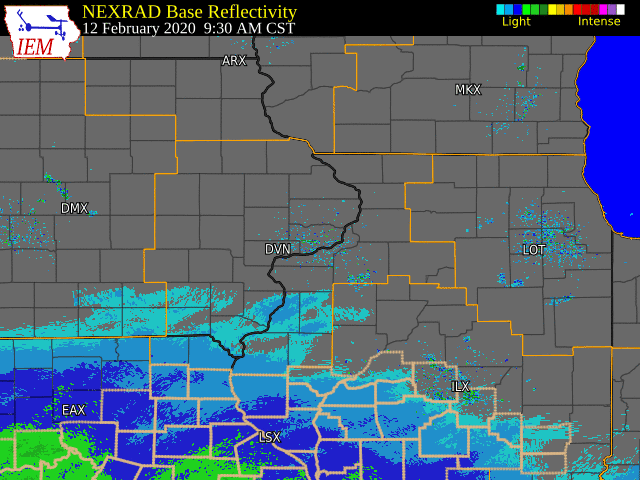
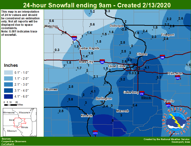
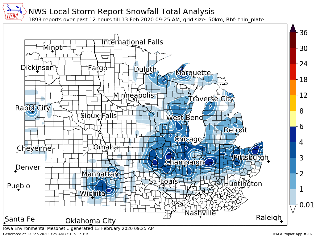
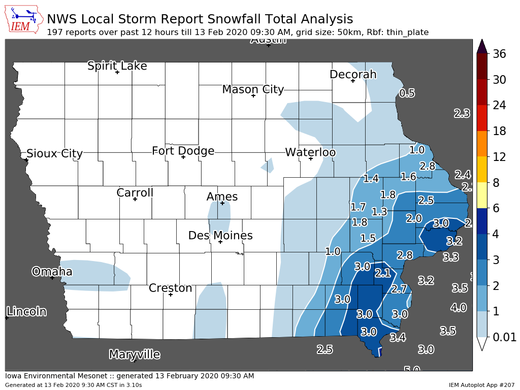
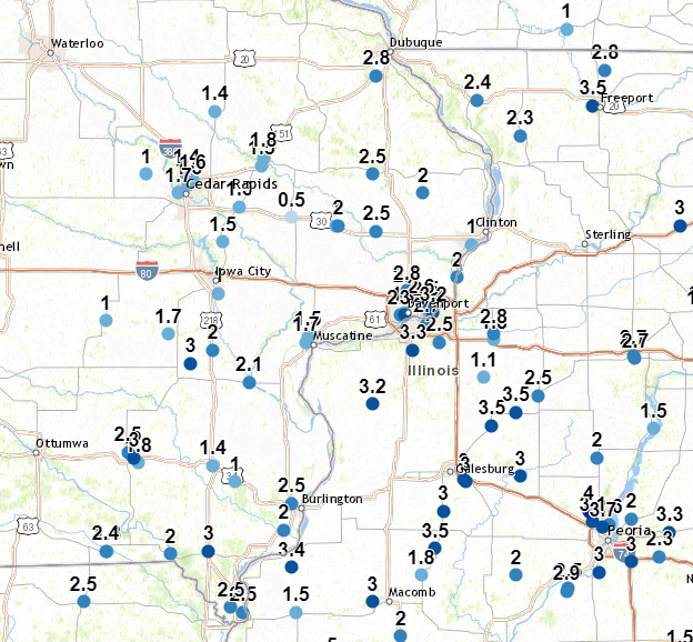
A winter storm spread light to moderate snow across much of eastern Iowa, northwest Illinois, and northeast Missouri. The snow began Wednesday (Feb 12) afternoon and ended early Thursday (Feb 13) morning Snowfall amounts ranged from around 1 inch along a line from Manchester IA to Cedar Rapids IA to Sigourney IA, to near 4 inches in west central Illinois. A snow total of 5 inches was measured at the Augusta IL (Hancock Co IL) NWS COOP station. In addition to the snow, strong winds gusts up to 40 mph were seen Wednesday night and early Thursday as an arctic cold front pushed through the area. This caused some blowing and drifting of snow, leading to hazardous travel conditions and a few accidents for the Thursday morning commute.
Official NWS Obs: Moline: 3.3" Davenport: 2.8" Dubuque: 2.8" |
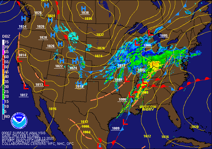 Surface Map 02/12-02/13 |
Snow/Ice
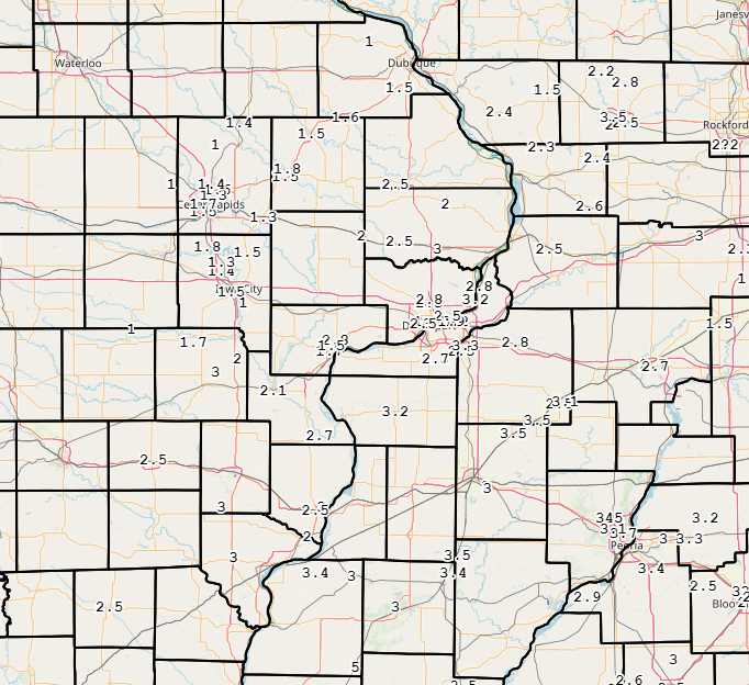
| Local Snowfall Map | Regional Snowfall Map (930 AM) |
Iowa Snowfall Analysis (930 AM) |
 |
 |
 |
24 hour snow fall in inches, for eastern Iowa, northwest and west central Illinois, and northeast Missouri. Reported between 6 AM and 9 AM, Thursday February 13, 2020. ....IOWA.... Keokuk LD19 4.0 Keosauqua 3.8 Centerville 0 NE 3.5 Bettendorf 2.2 SE 3.2 Eldridge 0.7 SSW 3.2 Salem 1S 3.0 Davenport 0.9 SSW 3.0 De Witt 3.0 Donnellson 3.0 Davenport Arpt 2.8 Dubuque Arpt 2.8 Wapello 5.4 SE 2.7 Maquoketa 4 W 2.5 Fairfield 2.5 Calamus 2.0 NE 2.5 Columbus Jct 2 SSW 2.1 Dubuque LD11 2.0 Burlington 6.5 SSW 2.0 Ainsworth 7.4 N 2.0 Charlotte 1.9 WNW 2.0 Rathbun Reservoir 2 N 1.9 Riverdale 0.5 N 1.9 Davenport 0.9 WNW 1.8 Wellman 4.0 E 1.7 Cascade 1.6 Anamosa 3 SSW 1.5 Muscatine 2.1 N 1.5 Bellevue LD12 1.5 Cedar Rapids 2.5 WSW 1.5 Solon 0.3 ESE 1.5 Parnell 0.1 SSW 1.5 Monticello 1 E 1.5 Coggon 1.4 North Liberty 0.7 SSW 1.4 Elkader 6SSW 1.2 Toledo 3 N 1.0 North English 1.0 Central City 6.7 W 1.0 Mason City 1 NNE 1.0 Iowa City 1.0 Rickardsville 0.2 W 1.0 Shellsburg 2.9 S 1.0 Waukon 1.0 Hampton 1 N 1.0 Fayette 1 NW 0.7 Beaconsfield 1 NNE 0.6 Manchester 0.6 NWS Johnston* 5 NNW 0.6 Boone 1 SSW 0.6 Waterloo ASOS 5 NW 0.6 Mount Auburn 2.2 NNW 0.5 Marshalltown 1 NW 0.5 Guttenberg Dam 10 0.3 Belle Plaine 0.3 Perry 0 W 0.2 Cresco 1 NE 0.0 ....ILLINOIS.... Augusta 5.0 Freeport 3.6 Freeport 1.7 NW 3.5 Ogden 3.4 Dallas City 3.0 SSE 3.4 Prairie City 2S 3.4 Quad City Arpt 3.3 Romeoville 3.3 Coal Valley 2.6 E 3.3 Jacksonville 2E 3.3 Aledo 3.2 Mundelein 3.1 Kewanee 1 E 3.1 La Harpe 3.0 Colchester 3.5 NE 3.0 Tuscola 3.0 Dakota 4.8 NW 2.8 Princeton 1.1 SE 2.7 Princeton 2.7 Freeport 1.7 ESE 2.5 Coal Valley 1.9 SE 2.5 Ottawa 4 SW 2.4 Gladstone LD18 2.4 Shannon 0.2 S 2.4 St Anne 2.4 Elizabeth 2.4 Steward 2.3 Mount Carroll 6.8 NNW 2.3 Rockford ASOS 2.2 Winslow 4.3 ESE 2.2 Windsor 2.0 Freeport 2.9 WSW 2.0 Ill. City LD16 3 WNW 2.0 Mendota 2 SE 1.5 Stockton 3.4 NNE 1.5 Freeport 2.0 NW 1.5 Paw Paw 1 E 1.2 ....MISSOURI.... Memphis 2.5 Columbia 2.0 ....WISCONSIN.... Beloit-College 4.0 Brodhead 1 SW 2.6 Monroe 1 W 2.2 Madison-ASOS 2.1 Viroqua 1.2 La Crosse WFO 1.0 Steuben 4SE 3 NE 0.6 ....MINNESOTA.... Theilman 1SSW 0.0 |
Storm Reports
Storm Reports Map - Courtesy IEM
|
|
 |
PRELIMINARY LOCAL STORM REPORT...SUMMARY
NATIONAL WEATHER SERVICE QUAD CITIES IA IL
954 AM CST THU FEB 13 2020

..TIME...   ...EVENT...      ...CITY LOCATION...     ...LAT.LON...
..DATE...   ....MAG....      ..COUNTY LOCATION..ST.. ...SOURCE....
            ..REMARKS..

0905 AM     SNOW             1 WNW MORRISON          41.81N 89.98W
02/13/2020  M2.5 INCH        WHITESIDE          IL   TRAINED SPOTTER


0851 AM     SNOW             3 N STOCKTON            42.40N 90.00W
02/13/2020  M1.5 INCH        JO DAVIESS         IL   CO-OP OBSERVER

            6 INCH SNOW DEPTH WITH 1.5 INCHES OF NEW
            SNOW.

0847 AM     SNOW             1 W COU FALLS           41.82N 91.69W
02/13/2020  M1.8 INCH        JOHNSON            IA   PUBLIC


0824 AM     SNOW             2 N BURLINGTON          40.84N 91.12W
02/13/2020  M3.0 INCH        DES MOINES         IA   TRAINED SPOTTER

            EVENT TOTAL.

0822 AM     SNOW             1 SW UNIVERSITY HEIGHTS 41.65N 91.57W
02/13/2020  M1.5 INCH        JOHNSON            IA   TRAINED SPOTTER

            EVENT TOTAL.

0820 AM     SNOW             MILLEDGEVILLE           41.97N 89.78W
02/13/2020  M2.6 INCH        CARROLL            IL   TRAINED SPOTTER

            EVENT TOTAL.

0820 AM     SNOW             SHANNON                 42.15N 89.74W
02/13/2020  M2.4 INCH        CARROLL            IL   TRAINED SPOTTER

            EVENT TOTAL.

0816 AM     SNOW             2 NNW NORTH LIBERTY     41.76N 91.62W
02/13/2020  M1.3 INCH        JOHNSON            IA   TRAINED SPOTTER

            EVENT TOTAL.

0815 AM     SNOW             1 SSW CORDOVA           41.67N 90.33W
02/13/2020  M2.8 INCH        ROCK ISLAND        IL   TRAINED SPOTTER

            EVENT TOTAL.

0800 AM     SNOW             3 W CENTER JUNCTION     42.11N 91.14W
02/13/2020  M2.0 INCH        JONES              IA   COCORAHS

            COCORAHS STATION IA-JN-10 CENTER JUNCTION
            2.6 W.

0800 AM     SNOW             2 NNW WARNER            41.45N 90.40W
02/13/2020  M3.3 INCH        HENRY              IL   COCORAHS

            COCORAHS STATION IL-HY-15 COAL VALLEY 2.6 E.

0800 AM     SNOW             1 SSE DEWITT            41.81N 90.54W
02/13/2020  M3.0 INCH        CLINTON            IA   CO-OP OBSERVER

            CO-OP OBSERVER STATION DWTI4 DE WITT.

0800 AM     SNOW             LA HARPE                40.58N 90.97W
02/13/2020  M3.0 INCH        HANCOCK            IL   CO-OP OBSERVER

            CO-OP OBSERVER STATION LAHI2 LA HARPE.

0800 AM     SNOW             1 SSW NORTH LIBERTY     41.73N 91.62W
02/13/2020  M1.4 INCH        JOHNSON            IA   COCORAHS

            COCORAHS STATION IA-JH-27 NORTH LIBERTY 0.7
            SSW.

0800 AM     SNOW             SIGOURNEY               41.33N 92.20W
02/13/2020  M1.5 INCH        KEOKUK             IA   CO-OP OBSERVER

            CO-OP OBSERVER STATION SGYI4 SIGOURNEY.

0755 AM     SNOW             1 NNE FAIRFIELD         41.02N 91.96W
02/13/2020  M2.5 INCH        JEFFERSON          IA   CO-OP OBSERVER

            EVENT TOTAL.

0745 AM     SNOW             2 NW FREEPORT           42.31N 89.66W
02/13/2020  M1.5 INCH        STEPHENSON         IL   COCORAHS

            COCORAHS STATION IL-SP-6 FREEPORT 2.0 NW.

0743 AM     SNOW             1 W BETTENDORF          41.56N 90.49W
02/13/2020  M2.5 INCH        SCOTT              IA   TRAINED SPOTTER


0734 AM     SNOW             1 ENE MOUNT VERNON      41.93N 91.41W
02/13/2020  M1.3 INCH        LINN               IA   TRAINED SPOTTER

            EVENT TOTAL.

0730 AM     SNOW             COLUMBUS JUNCTION       41.28N 91.36W
02/13/2020  M2.1 INCH        LOUISA             IA   CO-OP OBSERVER

            EVENT TOTAL.

0730 AM     SNOW             3 ENE BOLTON            42.27N 89.68W
02/13/2020  M2.0 INCH        STEPHENSON         IL   COCORAHS

            COCORAHS STATION IL-SP-26 FREEPORT 2.9 WSW.

0729 AM     SNOW             LOWDEN                  41.86N 90.92W
02/13/2020  M2.0 INCH        CEDAR              IA   CO-OP OBSERVER

            EVENT TOTAL.

0719 AM     SNOW             1 NNW MONTICELLO MUNICI 42.24N 91.17W
02/13/2020  M1.5 INCH        JONES              IA   CO-OP OBSERVER

            CO-OP OBSERVER STATION MCLI4 MONTICELLO.

0714 AM     SNOW             1 NNW MUSCATINE         41.43N 91.08W
02/13/2020  M1.7 INCH        MUSCATINE          IA   TRAINED SPOTTER

            EVENT TOTAL.

0707 AM     SNOW             2 S DAVENPORT           41.53N 90.61W
02/13/2020  M2.5 INCH        SCOTT              IA   PUBLIC


0703 AM     SNOW             1 SSW KEWANEE           41.23N 89.93W
02/13/2020  M2.5 INCH        HENRY              IL   TRAINED SPOTTER

            EVENT TOTAL.

0700 AM     SNOW             4 N HASKINS             41.40N 91.54W
02/13/2020  M2.0 INCH        WASHINGTON         IA   COCORAHS

            COCORAHS STATION IA-WS-2 AINSWORTH 7.4 N.

0700 AM     SNOW             ALEDO                   41.20N 90.75W
02/13/2020  M3.2 INCH        MERCER             IL   CO-OP OBSERVER

            CO-OP OBSERVER STATION ALEI2 ALEDO.

0700 AM     SNOW             2 WSW SPRING GROVE      40.73N 91.19W
02/13/2020  M2.0 INCH        DES MOINES         IA   COCORAHS

            COCORAHS STATION IA-DM-7 BURLINGTON 6.5 SSW.

0700 AM     SNOW             2 NE CALAMUS            41.84N 90.73W
02/13/2020  M2.5 INCH        CLINTON            IA   COCORAHS

            COCORAHS STATION IA-CN-2 CALAMUS 2.0 NE.

0700 AM     SNOW             1 E CASCADE             42.30N 91.00W
02/13/2020  M1.6 INCH        DUBUQUE            IA   CO-OP OBSERVER

            CO-OP OBSERVER STATION CASI4 CASCADE.

0700 AM     SNOW             4 NNE LAFAYETTE         42.20N 91.65W
02/13/2020  M1.0 INCH        LINN               IA   COCORAHS

            COCORAHS STATION IA-LN-7 CENTRAL CITY 6.7 W.

0700 AM     SNOW             2 WNW CHARLOTTE         41.98N 90.50W
02/13/2020  M2.0 INCH        CLINTON            IA   COCORAHS

            COCORAHS STATION IA-CN-17 CHARLOTTE 1.9 WNW.

0700 AM     SNOW             2 SE COAL VALLEY        41.43N 90.42W
02/13/2020  M2.5 INCH        HENRY              IL   COCORAHS

            COCORAHS STATION IL-HY-5 COAL VALLEY 1.9 SE.

0700 AM     SNOW             3 W MACOMB              40.46N 90.75W
02/13/2020  M3.0 INCH        MCDONOUGH          IL   COCORAHS

            COCORAHS STATION IL-MCD-7 COLCHESTER 3.5 NE.

0700 AM     SNOW             2 W AFOLKEY             42.43N 89.60W
02/13/2020  M2.8 INCH        STEPHENSON         IL   COCORAHS

            COCORAHS STATION IL-SP-23 DAKOTA 4.8 NW.

0700 AM     SNOW             DONNELLSON              40.65N 91.56W
02/13/2020  M3.0 INCH        LEE                IA   CO-OP OBSERVER

            CO-OP OBSERVER STATION DNNI4 DONNELLSON.

0700 AM     SNOW             3 SSE ATKINS            41.96N 91.84W
02/13/2020  M1.0 INCH        BENTON             IA   COCORAHS

            COCORAHS STATION IA-BT-12 FAIRFAX 4.0 NW.

0700 AM     SNOW             2 ESE FREEPORT          42.28N 89.60W
02/13/2020  M2.5 INCH        STEPHENSON         IL   COCORAHS

            COCORAHS STATION IL-SP-14 FREEPORT 1.7 ESE.

0700 AM     SNOW             2 SSE BUCK CREEK        42.30N 91.34W
02/13/2020  M1.3 INCH        DELAWARE           IA   COCORAHS

            COCORAHS STATION IA-DW-6 HOPKINTON 5.4 WSW.

0700 AM     SNOW             3 SE IOWA CITY MUNICIPA 41.61N 91.51W
02/13/2020  M1.0 INCH        JOHNSON            IA   CO-OP OBSERVER

            CO-OP OBSERVER STATION ICYI4 IOWA CITY.

0700 AM     SNOW             1 E KEWANEE             41.24N 89.90W
02/13/2020  M3.1 INCH        HENRY              IL   CO-OP OBSERVER

            CO-OP OBSERVER STATION KEWI2 KEWANEE 1 E.

0700 AM     SNOW             2 NNE LE CLAIRE         41.62N 90.35W
02/13/2020  M3.2 INCH        SCOTT              IA   COCORAHS

            COCORAHS STATION IA-ST-1 LE CLAIRE 1.8 NNE.

0700 AM     SNOW             1 W MAQUOKETA MUNICIPAL 42.05N 90.75W
02/13/2020  M2.5 INCH        JACKSON            IA   CO-OP OBSERVER

            CO-OP OBSERVER STATION MKTI4 MAQUOKETA.

0700 AM     SNOW             6 SSE ELMOVILLE         42.19N 90.02W
02/13/2020  M2.3 INCH        CARROLL            IL   COCORAHS

            COCORAHS STATION IL-CR-12 MOUNT CARROLL 6.8
            NNW.

0700 AM     SNOW             2 N MUSCATINE           41.47N 91.05W
02/13/2020  M2.8 INCH        MUSCATINE          IA   CO-OP OBSERVER

            EVENT TOTAL.

0700 AM     SNOW             2 N MUSCATINE           41.45N 91.07W
02/13/2020  M1.5 INCH        MUSCATINE          IA   COCORAHS

            COCORAHS STATION IA-MC-13 MUSCATINE 2.1 N.

0700 AM     SNOW             NORTH ENGLISH           41.51N 92.07W
02/13/2020  M1.0 INCH        IOWA               IA   CO-OP OBSERVER

            CO-OP OBSERVER STATION NENI4 NORTH ENGLISH.

0700 AM     SNOW             PARK VIEW               41.69N 90.54W
02/13/2020  M3.2 INCH        SCOTT              IA   COCORAHS

            COCORAHS STATION IA-ST-3 PARK VIEW 0.2 WSW.

0700 AM     SNOW             PRINCETON               41.38N 89.46W
02/13/2020  M2.7 INCH        BUREAU             IL   CO-OP OBSERVER

            CO-OP OBSERVER STATION PTNI2 PRINCETON.

0700 AM     SNOW             1 SE PRINCETON          41.37N 89.45W
02/13/2020  M2.7 INCH        BUREAU             IL   COCORAHS

            COCORAHS STATION IL-BU-5 PRINCETON 1.1 SE.

0700 AM     SNOW             1 S SALEM               40.84N 91.62W
02/13/2020  M3.0 INCH        HENRY              IA   CO-OP OBSERVER

            CO-OP OBSERVER STATION SLHI4 SALEM 1 S.

0700 AM     SNOW             SHANNON                 42.15N 89.74W
02/13/2020  M2.4 INCH        CARROLL            IL   COCORAHS

            COCORAHS STATION IL-CR-13 SHANNON 0.2 S.

0700 AM     SNOW             3 S SHELLSBURG          42.05N 91.87W
02/13/2020  M1.0 INCH        BENTON             IA   COCORAHS

            COCORAHS STATION IA-LN-36 SHELLSBURG 2.9 S.

0700 AM     SNOW             3 NNE STOCKTON          42.40N 89.99W
02/13/2020  M1.5 INCH        JO DAVIESS         IL   COCORAHS

            COCORAHS STATION IL-JD-8 STOCKTON 3.4 NNE.

0700 AM     SNOW             3 ESE AMBER             41.11N 91.13W
02/13/2020  M2.7 INCH        LOUISA             IA   COCORAHS

            COCORAHS STATION IA-LS-5 WAPELLO 5.4 SE.

0700 AM     SNOW             3 NNE MC CONNELL        42.47N 89.72W
02/13/2020  M2.2 INCH        STEPHENSON         IL   COCORAHS

            COCORAHS STATION IL-SP-8 WINSLOW 4.3 ESE.

0644 AM     SNOW             SOLON                   41.80N 91.49W
02/13/2020  M1.5 INCH        JOHNSON            IA   TRAINED SPOTTER

            EVENT TOTAL.

0630 AM     SNOW             1 ENE RIVERDALE         41.54N 90.45W
02/13/2020  M3.2 INCH        SCOTT              IA   COCORAHS

            COCORAHS STATION IA-ST-8 BETTENDORF 2.2 SE.

0630 AM     SNOW             2 SW CEDAR RAPIDS       41.95N 91.71W
02/13/2020  M1.5 INCH        LINN               IA   PUBLIC


0630 AM     SNOW             2 SSE DAVENPORT         41.53N 90.59W
02/13/2020  M3.0 INCH        SCOTT              IA   COCORAHS

            COCORAHS STATION IA-ST-4 DAVENPORT 0.9 SSW.

0630 AM     SNOW             1 SE DAVENPORT          41.54N 90.59W
02/13/2020  M1.8 INCH        SCOTT              IA   COCORAHS

            COCORAHS STATION IA-ST-37 DAVENPORT 0.9 WNW.

0630 AM     SNOW             ELIZABETH               42.32N 90.23W
02/13/2020  M2.4 INCH        JO DAVIESS         IL   CO-OP OBSERVER

            CO-OP OBSERVER STATION EZBI2 ELIZABETH.

0630 AM     SNOW             3 W RICHMOND            41.46N 91.76W
02/13/2020  M1.7 INCH        WASHINGTON         IA   COCORAHS

            COCORAHS STATION IA-WS-7 WELLMAN 4.0 E.

0600 AM     SNOW             2 ESE FAIRVIEW          42.08N 91.30W
02/13/2020  M1.5 INCH        JONES              IA   CO-OP OBSERVER

            CO-OP OBSERVER STATION AMOI4 ANAMOSA 3 SSW.

0600 AM     SNOW             COGGON                  42.28N 91.53W
02/13/2020  M1.4 INCH        LINN               IA   CO-OP OBSERVER

            CO-OP OBSERVER STATION CGGI4 COGGON.

0600 AM     SNOW             2 NE COLUSA             40.59N 91.15W
02/13/2020  M3.4 INCH        HANCOCK            IL   PUBLIC


0600 AM     SNOW             DAVENPORT MUNICIPALITY  41.62N 90.58W
02/13/2020  M2.8 INCH        SCOTT              IA   OFFICIAL NWS OBS

            EVENT TOTAL. 0.3 INCHES IN PAST 6 HOURS.

0600 AM     SNOW             DUBUQUE REGIONAL ARPT   42.41N 90.73W
02/13/2020  M2.8 INCH        DUBUQUE            IA   OFFICIAL NWS OBS

            EVENT TOTAL. 1.3 INCHES IN PAST 6 HRS.

0600 AM     SNOW             1 WSW MEMPHIS           40.46N 92.18W
02/13/2020  M2.5 INCH        SCOTLAND           MO   CO-OP OBSERVER

            CO-OP OBSERVER STATION MMPM7 MEMPHIS.

0600 AM     SNOW             MOLINE QUAD-CITY AIRPOR 41.40N 90.55W
02/13/2020  M3.3 INCH        ROCK ISLAND        IL   OFFICIAL NWS OBS

            EVENT TOTAL. 0.6 INCHES IN PAST 6 HRS.

0600 AM     SNOW             2 S PRAIRIE CITY        40.59N 90.46W
02/13/2020  M3.4 INCH        MCDONOUGH          IL   CO-OP OBSERVER

            CO-OP OBSERVER STATION PRCI2 2.0 S PRAIRIE
            CITY.

0600 AM     SNOW             RICKARDSVILLE           42.58N 90.88W
02/13/2020  M1.0 INCH        DUBUQUE            IA   COCORAHS

            COCORAHS STATION IA-DB-21 RICKARDSVILLE 0.2
            W.

0600 AM     SNOW             4 NE WASHINGTON         41.35N 91.65W
02/13/2020  M3.0 INCH        WASHINGTON         IA   PUBLIC


0551 AM     SNOW             3 NNE CEDAR RAPIDS      42.01N 91.66W
02/13/2020  M1.3 INCH        LINN               IA   TRAINED SPOTTER

            EVENT TOTAL.

0532 AM     SNOW             AUGUSTA                 40.23N 90.95W
02/13/2020  M5.0 INCH        HANCOCK            IL   CO-OP OBSERVER

            CO-OP OBSERVER STATION AUGI2 AUGUSTA.

0517 AM     SNOW             GALVA                   41.17N 90.04W
02/13/2020  M3.5 INCH        HENRY              IL   TRAINED SPOTTER

            EVENT TOTAL. LIGHT FLURRIES FALLING.


&&
 |
Media use of NWS Web News Stories is encouraged! Please acknowledge the NWS as the source of any news information accessed from this site. |
|