Severe thunderstorms will be possible from the central Plains to the Mid-Atlantic and Northeast on Monday. Hazardous heat will linger across the southern U.S. and build across the West through mid-week. Hot and dry conditions will fuel fire weather concerns for Interior Alaska and the Four Corners region through Monday. Read More >
Overview
|
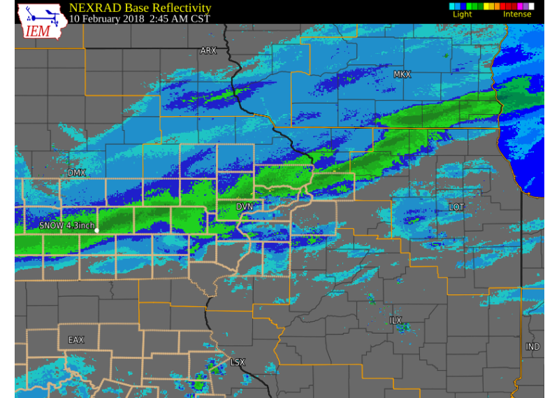
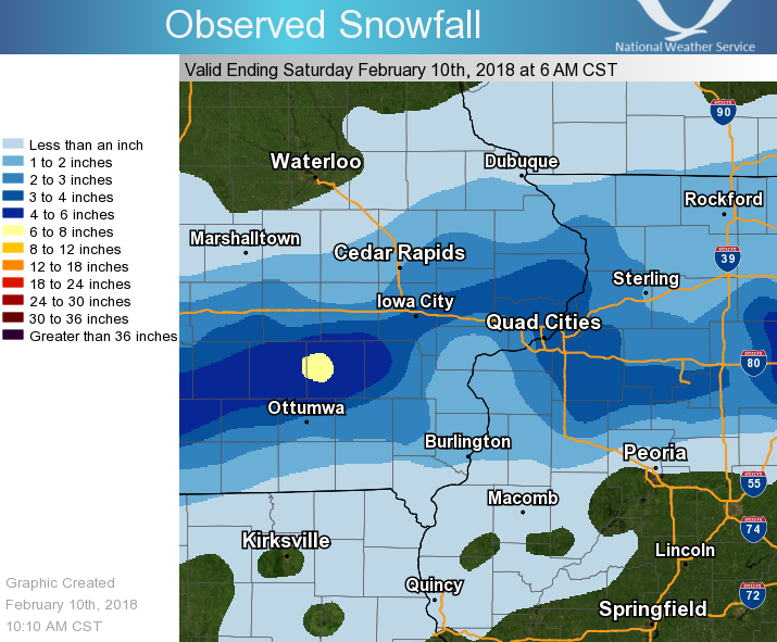
Another upper level storm system tracked east across the Plains and into Iowa Saturday morning, bringing snow to portions of eastern Iowa and northwest Illinois. Snow covered roads and reduced visibilities were seen as the snow fell between midnight and 10 am. Snowfall totals between 1 and 4 inches were common, with a few locally higher amounts. The highest totals fell in a narrow line from Sigourney, IA, to Iowa City, to Clinton Iowa. |
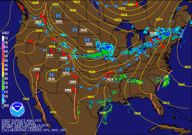 Surface Map |
Storm Reports:
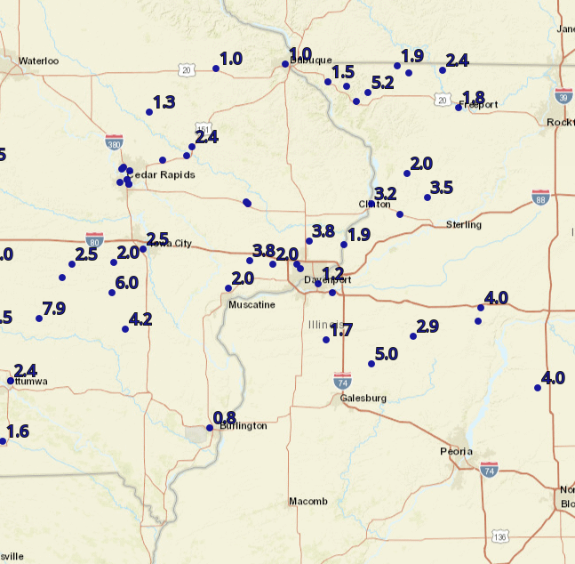 |
 |
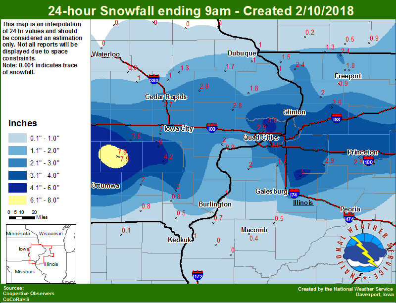 |
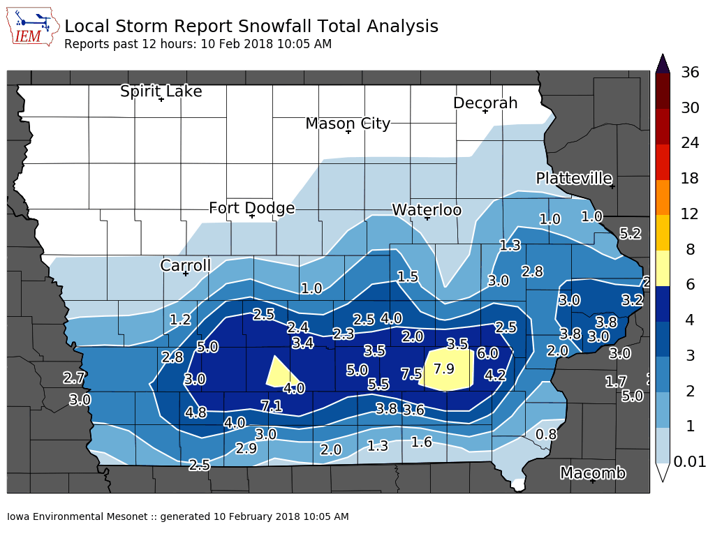
| Interactive Map Link | Iowa Snow Analysis Courtesy Iowa Environmental Mesonet |
Local Snowfall |
 |
 |
|
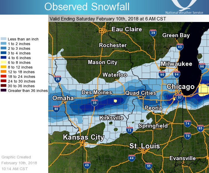
| Regional Snowfall | Midwest Snowfall |
THE REPORTS BELOW ARE SEPARATED INTO SNOW...AND ICE AND SLEET
CATEGORIES...THEN BY AMOUNT...AND ARE NOT NECESSARILY THE
FINAL AMOUNT FOR EACH LOCATION.


SNOW REPORTS LISTED BY AMOUNT

 INCHES  LOCATION                 ST  COUNTY           TIME
 ------  -----------------------  --  --------------   -------
  7.9    SIGOURNEY                IA  KEOKUK           0800 AM
  6.0    3 W RICHMOND             IA  WASHINGTON       0809 AM
  4.2    WASHINGTON               IA  WASHINGTON       0700 AM
  4.0    PRINCETON                IL  BUREAU           0700 AM
  3.8    SW DURANT                IA  CEDAR            0930 AM
  3.8    PARK VIEW                IA  SCOTT            0627 AM
  3.5    NORTH ENGLISH            IA  IOWA             0700 AM
  3.5    1 SW COLETA              IL  WHITESIDE        0700 AM
  3.2    4 ENE CLINTON            IL  WHITESIDE        0748 AM
  3.0    2 NNW WARNER             IL  HENRY            0800 AM
  3.0    1 WNW MORRISON           IL  WHITESIDE        0802 AM
  3.0    LOWDEN                   IA  CEDAR            0931 AM
  3.0    2 NNW DAVENPORT          IA  SCOTT            0730 AM
  3.0    2 NNE CEDAR RAPIDS       IA  LINN             0558 AM
  2.9    1 E KEWANEE              IL  HENRY            0700 AM
  2.8    4 NNW CEDAR RAPIDS       IA  LINN             0802 AM
  2.8    3 SSW ANAMOSA            IA  JONES            0700 AM
  2.7    2 WSW CEDAR RAPIDS       IA  LINN             0700 AM
  2.7    3 NNW CEDAR RAPIDS       IA  LINN             0759 AM
  2.6    NNW SPRINGVILLE          IA  LINN             0737 AM
  2.5    WNW PARNELL              IA  IOWA             0644 AM
  2.5    2 N TISKILWA             IL  BUREAU           0700 AM
  2.5    2 WSW IOWA CITY          IA  JOHNSON          0951 AM
  2.5    CEDAR RAPIDS             IA  LINN             0558 AM
  2.4    2 NNE MC CONNELL         IL  STEPHENSON       0700 AM
  2.4    ELIZABETH                IL  JO DAVIESS       0630 AM
  2.4    1 ENE ANAMOSA            IA  JONES            0802 AM
  2.2 DAVENPORT AIRPORT           IA  SCOTT            0619 AM
  2.0    1 NNW WILLIAMSTOWN       IA  JOHNSON          0700 AM
  2.0    1 S WALCOTT              IA  SCOTT            0804 AM
  2.0    2 N MUSCATINE            IA  MUSCATINE        0700 AM
  2.0    2 NNW MUSCATINE          IA  MUSCATINE        1030 AM
  2.0    FAIRFIELD                IA  JEFFERSON        0800 AM
  2.0    2 WSW CHADWICK           IL  CARROLL          0700 AM
  2.0    ALEDO                    IL  MERCER           0700 AM
  1.9    WSW WARREN               IL  JO DAVIESS       0930 AM
  1.9    1 SSW CORDOVA            IL  ROCK ISLAND      0930 AM
  1.8    4 W MOUNT PLEASANT       IA  HENRY            1027 AM
  1.8    1 E GALENA TERRITORY     IL  JO DAVIESS       0831 AM
  1.8    FREEPORT                 IL  STEPHENSON       0700 AM
  1.7    2 NNE NEW WINDSOR        IL  HENRY            0700 AM
  1.7    1 ESE NORA               IL  JO DAVIESS       1000 AM
  1.5    GALENA                   IL  JO DAVIESS       0700 AM
  1.5    6 SSW DUBUQUE            IA  DUBUQUE          1046 AM
  1.5    MOLINE AIRPORT           IL  ROCK ISLAND      0619 AM
  1.3    COGGON                   IA  LINN             0630 AM
  1.0    W CANTRIL                IA  VAN BUREN        1055 AM
  1.0    DYERSVILLE               IA  DUBUQUE          0930 AM
  1.0    DUBUQUE AIRPORT          IA  DUBUQUE          0619 AM
  0.8    1 E WEST BURLINGTON      IA  DES MOINES       0829 AM
  0.7    2 NE COLUSA              IL  HANCOCK          0600 AM
  0.5    DONNELLSON               IA  LEE              0700 AM
  0.4    2 ENE ARGYLE LAKE STATE  IL  MCDONOUGH        0700 AM
Environment:
 |
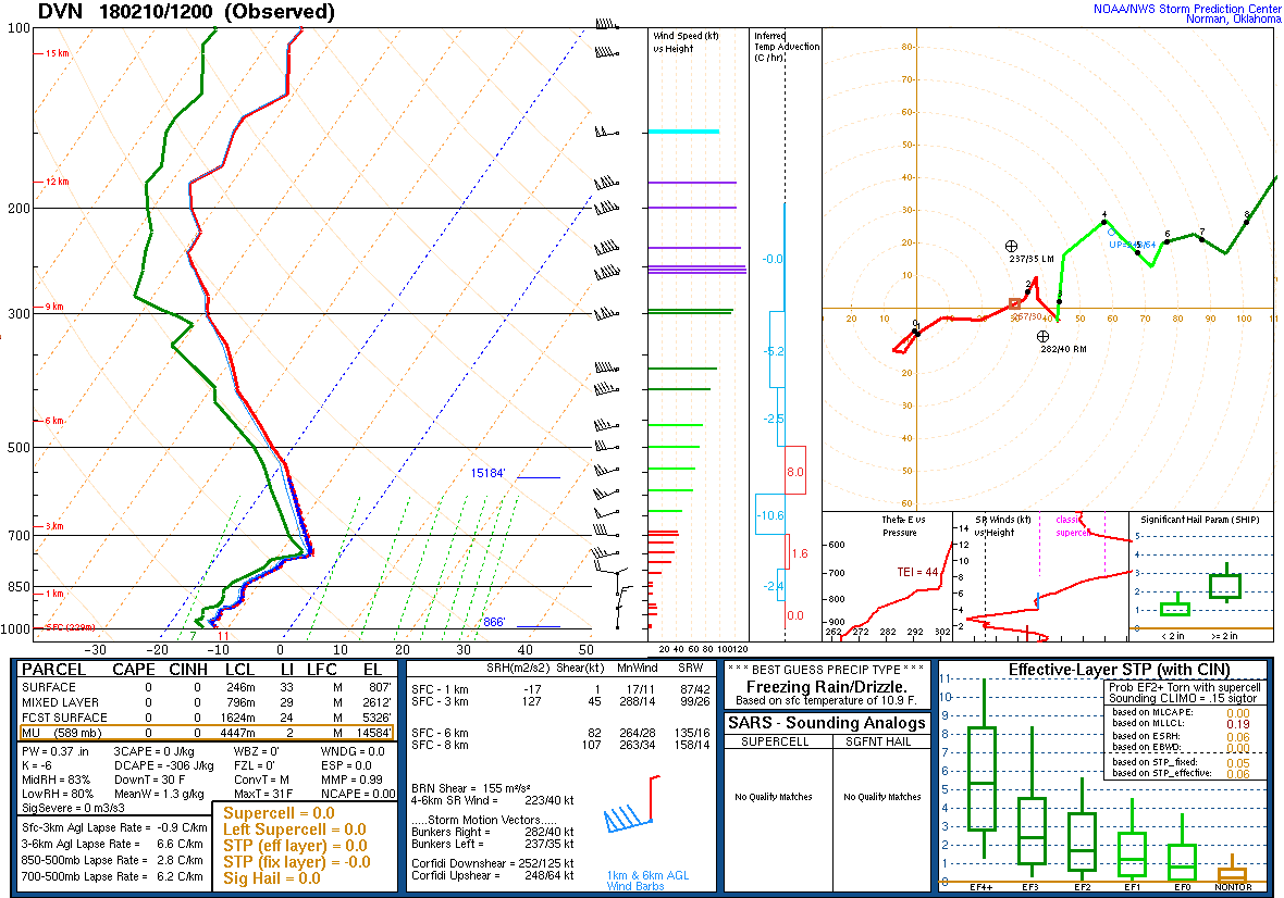 |
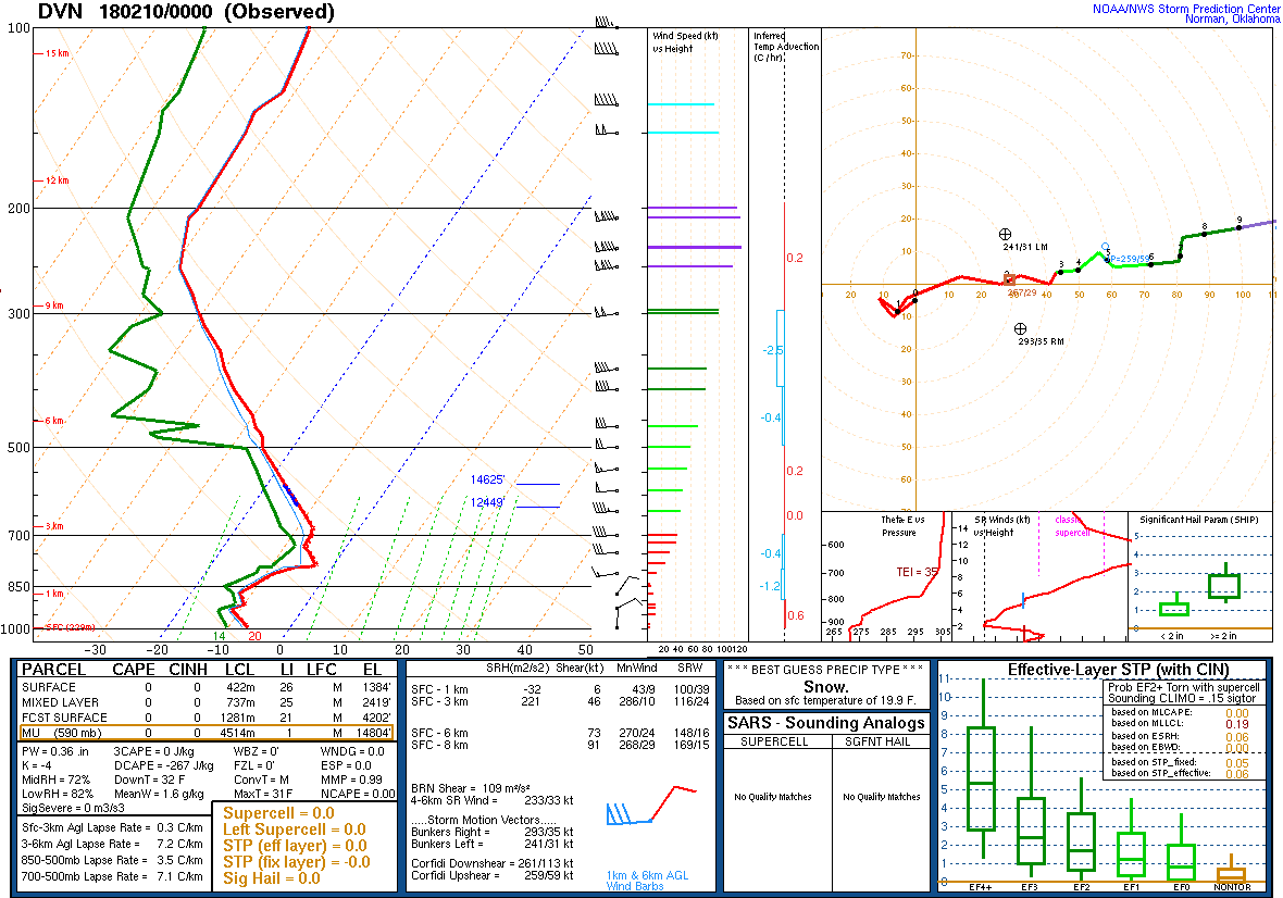
| Figure 2: 00Z 2/10 DVN Sounding | Figure 3: 12z 2/10 Sounding |
 |
Media use of NWS Web News Stories is encouraged! Please acknowledge the NWS as the source of any news information accessed from this site. |
|