Showers and thunderstorms will be possible from the northern Plains to the Gulf Coast on Monday. Thunderstorms with large hail and severe wind gusts are expected Monday afternoon and evening across parts of the central Plains. Read More >
Overview
|
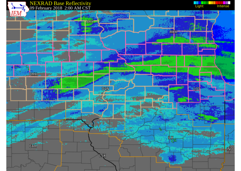
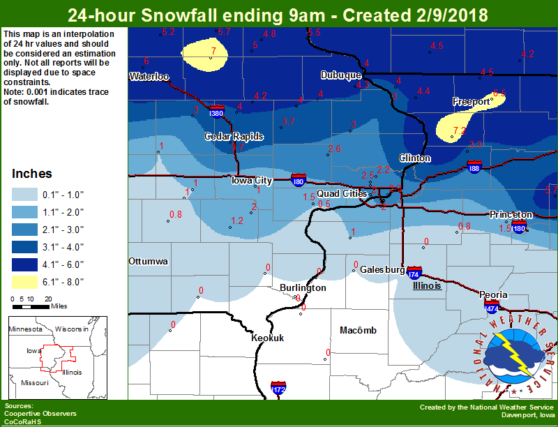
An upper level storm system tracked east across the eastern Great Plains into northern Missouri and Illinois on from Feb. 8-9, 2018, bringing widespread snow to portions of eastern Iowa and northwest Illinois. The heaviest snowfall fell along the Highway 20 corridor, where amounts of 6 to 8 inches were reported in Independence, Dubuque, and Freeport. To the south, around 2 to 5 inches fell from the Interstate 80 corridor to Highway 30. This page will update as more information becomes available. |
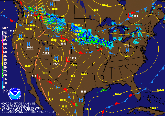 Surface Map |
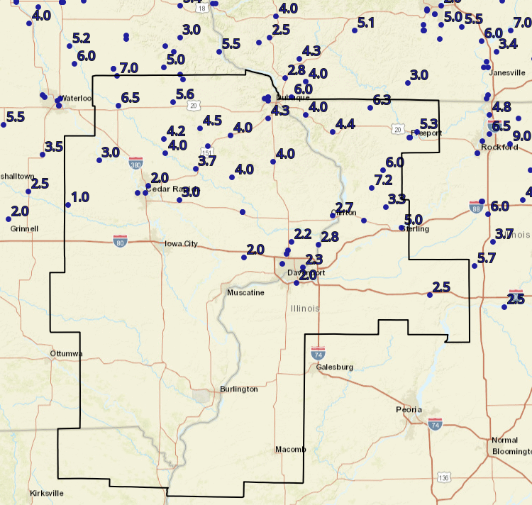
Storm Reports
 |
.png) |
 |
| Interactive Map Link | Iowa Snow Analysis Courtesy Iowa Environmental Mesonet |
Local Snowfall |
THE REPORTS BELOW ARE NOT NECESSARILY THE FINAL AMOUNT FOR EACH LOCATION.
Public Information Statement
National Weather Service Quad Cities IA IL
1055 AM CST Fri Feb 9 2018

...Snowfall Totals from February 8-9, 2018...

Location                     Amount    Time/Date       Lat/Lon
1 E Freeport                 8.0 in    0500 AM 02/09   42.29N/89.62W
2 WSW Chadwick               7.2 in    0836 AM 02/09   42.00N/89.92W
2 NNE Hazleton               7.0 in    0600 AM 02/09   42.64N/91.89W
Freeport                     6.5 in    0700 AM 02/09   42.29N/89.63W
1 ENE Independence           6.5 in    0539 AM 02/09   42.47N/91.88W
1 ENE Nora                   6.3 in    0916 AM 02/09   42.46N/89.93W
Lanark                       6.0 in    0500 AM 02/09   42.10N/89.83W
1 SE Asbury                  6.0 in    0803 AM 02/09   42.51N/90.75W
Manchester                   5.6 in    0700 AM 02/09   42.49N/91.46W
3 SW Winneshiek              5.3 in    0700 AM 02/09   42.32N/89.57W
Rock Falls                   5.0 in    0500 AM 02/09   41.77N/89.69W
3 NW Greeley                 5.0 in    0657 AM 02/09   42.62N/91.38W
Hopkinton                    4.5 in    1012 AM 02/09   42.34N/91.25W
Elizabeth                    4.4 in    0630 AM 02/09   42.32N/90.22W
Dubuque Regional Arpt        4.3 in    0600 AM 02/09   42.40N/90.72W
Coggon                       4.2 in    0630 AM 02/09   42.28N/91.53W
Unionville                   4.0 in    0759 AM 02/09   41.81N/89.98W
Central City                 4.0 in    0837 AM 02/09   42.20N/91.52W
Cascade                      4.0 in    0757 AM 02/09   42.30N/91.01W
Fulton                       4.0 in    1027 AM 02/09   42.15N/90.68W
Monticello                   4.0 in    0800 AM 02/09   42.24N/91.19W
Galena                       4.0 in    0700 AM 02/09   42.42N/90.43W
Wyoming                      4.0 in    0900 AM 02/09   42.06N/91.00W
Anamosa                      3.7 in    0630 AM 02/09   42.11N/91.28W
1 SSW Coleta                 3.3 in    0837 AM 02/09   41.89N/89.81W
3 W Cedar Rapids             3.2 in    0843 AM 02/09   41.97N/91.73W
1 NE Mount Vernon            3.0 in    0759 AM 02/09   41.93N/91.41W
Vinton                       3.0 in    0700 AM 02/09   42.16N/92.03W
1 SW Cordova                 2.8 in    0833 AM 02/09   41.67N/90.33W
1 ESE Clinton                2.7 in    0823 AM 02/09   41.84N/90.22W
Lowden                       2.6 in    0730 AM 02/09   41.86N/90.92W
Davenport Municipality       2.6 in    0600 AM 02/09   41.62N/90.58W
Eldridge                     2.5 in    0834 AM 02/09   41.64N/90.57W
Princeton                    2.5 in    0700 AM 02/09   41.38N/89.47W
1 ENE Riverdale              2.3 in    0837 AM 02/09   41.54N/90.45W
Park View                    2.2 in    0633 AM 02/09   41.69N/90.54W
Davenport                    2.0 in    0754 AM 02/09   41.56N/90.61W
Moline Quad-City Airport     2.0 in    0600 AM 02/09   41.45N/90.50W
Durant                       2.0 in    0813 AM 02/09   41.60N/90.91W
3 NNE Cedar Rapids           2.0 in    0523 AM 02/09   42.01N/91.65W
Belle Plaine                 1.0 in    0800 AM 02/09   41.90N/92.27W

Observations are collected from a variety of sources with varying
equipment and exposures. We thank all volunteer weather observers
for their dedication. Not all data listed are considered official.

$$
Highlighted locations are official NWS observations.
Environment
 |
 |
|
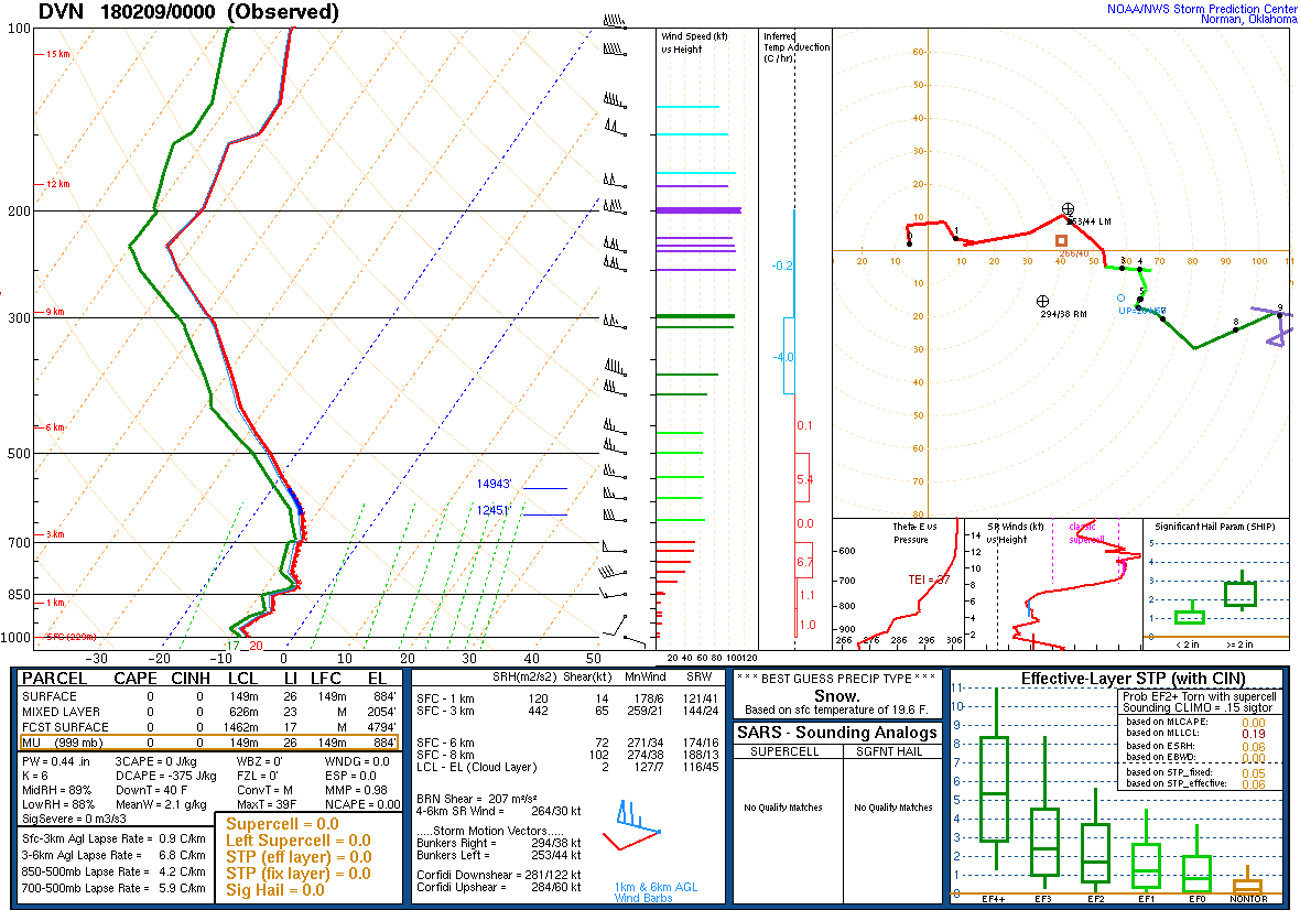
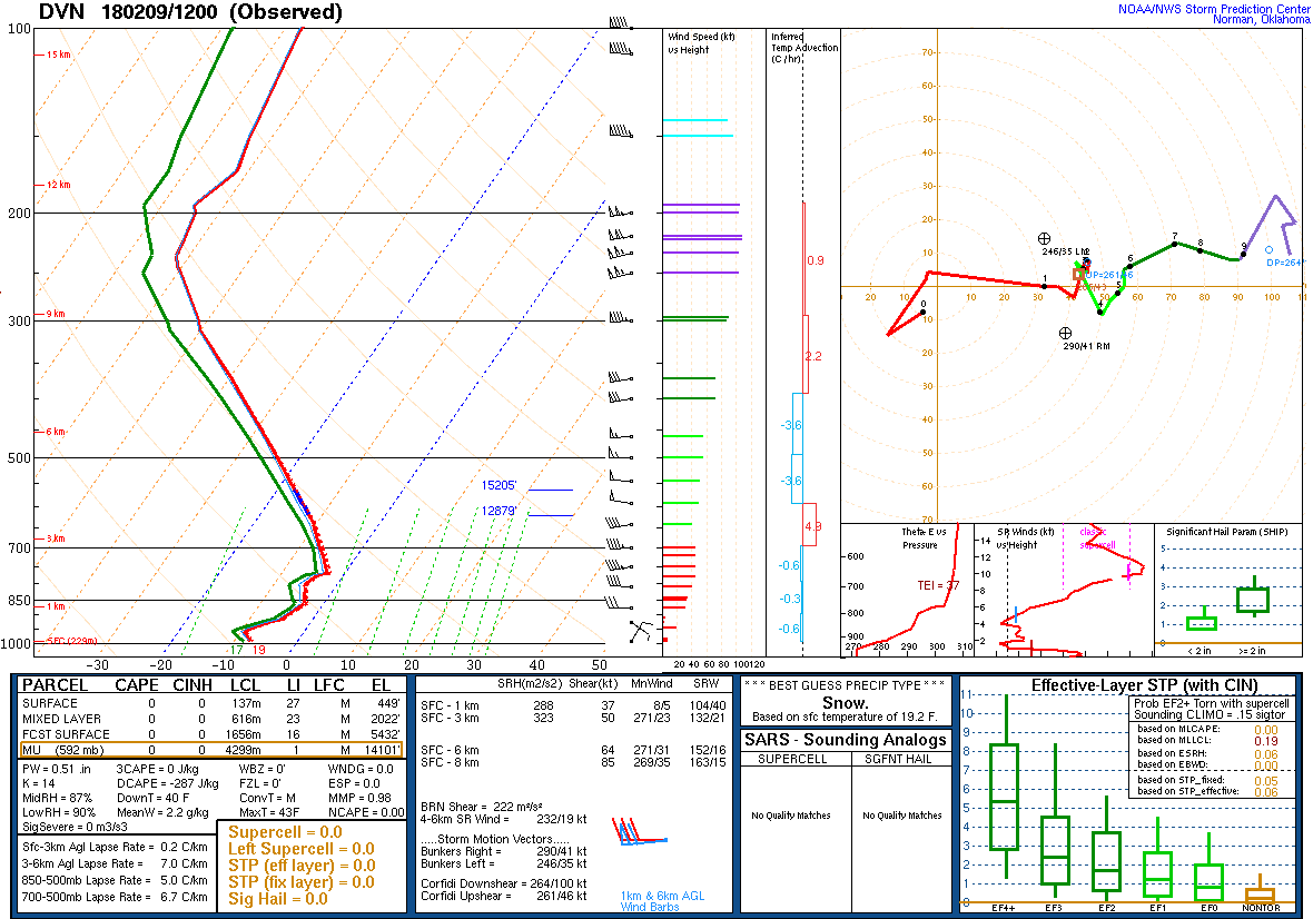
| Figure 1: 00Z 2/9 DVN Sounding | Figure 2: 12Z 2/9 DVN Sounding |
 |
Media use of NWS Web News Stories is encouraged! Please acknowledge the NWS as the source of any news information accessed from this site. |