Overview
|
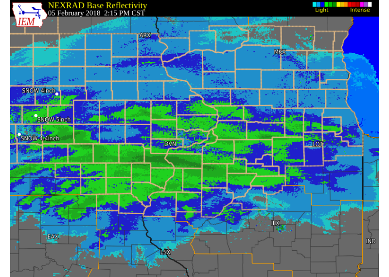
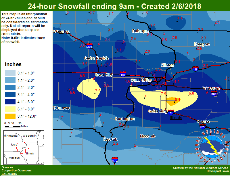
An upper level storm system tracked east across the Plains and Iowa on Monday, Feb. 5, 2018, bringing widespread snow to eastern Iowa, northwest Illinois, and northeast Missouri. Dry snow fell and covered the ground during the afternoon and evening. Snowfall totals between 2 and 6 inches were common, with light winds. Locally higher amounts between 6 and 11 inches fell in a narrow line from Sigourney, IA, to just northeast of Galesburg, IL. |
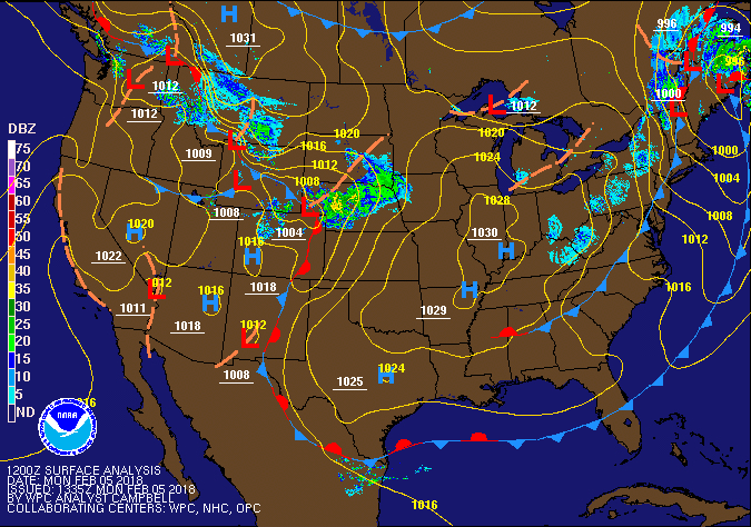 Surface Map |
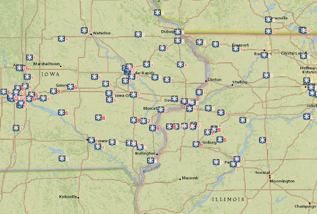
Storm Reports
 |
 |
 |
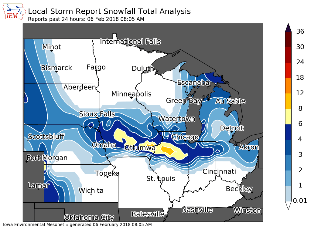
| Interactive Map Link | Iowa Snow Analysis Courtesy Iowa Environmental Mesonet |
Local Snowfall |
THE REPORTS BELOW ARE NOT NECESSARILY THE FINAL AMOUNT FOR EACH LOCATION.


SNOW REPORTS LISTED BY AMOUNT

 INCHES  LOCATION                 ST  COUNTY           TIME
 ------  -----------------------  --  --------------   -------
 10.5    GRANDVIEW                IA  LOUISA           0830 PM
  9.7    FREDONIA                 IA  LOUISA           0823 PM
  9.4    NEW BOSTON               IL  MERCER           0823 PM
  9.0    GALVA                    IL  HENRY            0914 PM
  9.0    ESE JOY                  IL  MERCER           0805 PM
  8.2    WASHINGTON               IA  WASHINGTON       0759 PM
  7.7    2 NE NEW WINDSOR         IL  HENRY            0757 PM
  7.3    1 E COLONA               IL  HENRY            1007 PM
  7.0    ALEDO                    IL  MERCER           0841 PM
  6.6    3 WSW IOWA CITY          IA  JOHNSON          0811 PM
  6.0    2 SE IOWA CITY           IA  JOHNSON          0747 PM
  5.8    1 SSW KEWANEE            IL  HENRY            0652 AM
  5.8    2 S BLUE GRASS           IA  SCOTT            0839 PM
  5.7    2 WSW IOWA CITY          IA  JOHNSON          0738 PM
  5.5    SSE REYNOLDS             IL  ROCK ISLAND      0959 PM
  5.5    SW MUSCATINE             IA  MUSCATINE        0810 PM
  5.3    1 W CAMBRIDGE            IL  HENRY            0900 AM
  5.0    1 W CAMBRIDGE            IL  HENRY            0759 PM
  4.8    2 NNW NORTH LIBERTY      IA  JOHNSON          0759 PM
  4.8    E SOLON                  IA  JOHNSON          0743 PM
  4.7    MOLINE QUAD-CITY AIRPOR  IL  ROCK ISLAND      1200 AM
  4.6    MONMOUTH                 IL  WARREN           0841 PM
  4.6    2 ENE PALO               IA  LINN             0811 PM
  4.5    1 SSE CEDAR RAPIDS       IA  LINN             0844 PM
  4.5    4 N MARENGO              IA  IOWA             0802 PM
  4.4    2 W CEDAR RAPIDS         IA  LINN             0750 PM
  4.3    ESE ERIE                 IL  WHITESIDE        0811 PM
  4.3    SW DAVENPORT             IA  SCOTT            0750 PM
  4.2    PARK VIEW                IA  SCOTT            0907 PM
  4.1    4 NNW DAVENPORT          IA  SCOTT            0757 PM
  4.1    NNW SPRINGVILLE          IA  LINN             0750 PM
  4.0    WASHINGTON               IA  WASHINGTON       0900 AM
  4.0    1 NW DAVENPORT           IA  SCOTT            0900 AM
  4.0    4 E GENESEO              IL  HENRY            0857 PM
  4.0    LOWDEN                   IA  CEDAR            0811 PM
  4.0    4 NE CLINTON             IA  CLINTON          0811 PM
  4.0    ELDRIDGE                 IA  SCOTT            0750 PM
  4.0    1 SE VINTON              IA  BENTON           0750 PM
  4.0    BETTENDORF               IA  SCOTT            0750 PM
  4.0    2 NW MARION              IA  LINN             0747 PM
  4.0    1 NNW MAQUOKETA          IA  JACKSON          0743 PM
  3.9    DAVENPORT MUNICIPAL AIR  IA  SCOTT            0945 PM
  3.6    NNW MILLEDGEVILLE        IL  CARROLL          1030 PM
  3.6    1 E FREEPORT             IL  STEPHENSON       0959 PM
  3.5    1 N GENESEO              IL  HENRY            0410 AM
  3.5    1 WNW MORRISON           IL  WHITESIDE        0803 PM
  3.2    2 N ELY                  IA  LINN             0720 PM
  3.1    1 ESE NEW LONDON         IA  HENRY            0742 PM
  3.0    1 NE FORT MADISON        IA  LEE              0900 AM
  3.0    2 WNW BURLINGTON         IA  DES MOINES       0908 PM
  3.0    2 SSE BURLINGTON         IA  DES MOINES       0808 PM
  2.8    2 WNW FREEPORT           IL  STEPHENSON       0841 PM
  2.8    1 NE FORT MADISON        IA  LEE              0800 PM
  2.7    E WYOMING                IA  JONES            0805 PM
  2.7    SE STANWOOD              IA  CEDAR            0729 PM
  2.6    SSE SHANNON              IL  CARROLL          0900 AM
  2.6    SSE SHANNON              IL  CARROLL          0817 AM
  2.1    DUBUQUE REGIONAL AIRPOR  IA  DUBUQUE          0945 PM
  2.0    INDUSTRY                 IL  MCDONOUGH        0948 PM
  2.0    ESE CARTHAGE             IL  HANCOCK          0927 PM
  2.0    1 ESE NORA               IL  JO DAVIESS       0832 PM
  1.8    2 WSW INDUSTRY           IL  MCDONOUGH        0900 AM
  1.5    W KEOSAUQUA              IA  VAN BUREN        0842 PM
  1.0    5 E CANTRIL              IA  VAN BUREN        0900 AM
  1.0    5 E CANTRIL              IA  VAN BUREN        0736 AM
  1.0    INDUSTRY                 IL  MCDONOUGH        0743 PM


24 hour snow fall in inches,
for eastern Iowa, northwest and west central Illinois,
and northeast Missouri. Reported between Midnight and 9 AM,
Tuesday February 06, 2018.

....IOWA....
Washington                        7.5
Oskaloosa                         6.0
NWS Johnston*                     6.0
Kalona 7.3 NNW                    6.0
Boone                             5.8
Parnell 0.1 SSW                   5.8
Sigourney 1.1 W                   5.6
Sigourney                         5.6
Pella                             5.5
Ainsworth 7.4 N                   5.5
Monticello                        5.0
Toledo                            5.0
Perry                             5.0
Bettendorf 2.2 SE                 4.8
Solon 0.3 ESE                     4.8
Muscatine 2N                      4.6
Davenport 0.9 SSW                 4.3
Park View 0.2 WSW                 4.2
Lowden                            4.1
Cedar Rapids 2.2 WSW              4.0
Marshalltown                      4.0
Central City 6.7 W                4.0
Eldridge 0.7 SSW                  4.0
Davenport Arpt                    3.9
Anamosa 3 SSW                     3.7
Vinton                            3.6
Cedar Rapids 2.7 NE               3.5
Dubuque LD11                      3.5
Amana 4.7 W                       3.5
Davenport 0.9 WNW                 3.5
Coggon                            3.4
Ely 0.5 SE                        3.2
Waterloo ASOS                     3.0
Mount Auburn 2.2 NNW              3.0
Hampton                           3.0
Guttenberg Dam 10                 3.0
Maquoketa 4W                      2.9
Fayette                           2.7
Bellevue LD12                     2.5
Burlington 6.5 SSW                2.5
Cascade                           2.5
Manchester                        2.4
Stanley                           2.3
Dubuque Arpt                      2.1
Salem 1S                          2.0
Tripoli                           2.0
Donnellson                        2.0
Mason City                        2.0
Bloomfield                        1.7
Cresco                            1.7
Rathbun Reservoir                 1.6
Elkader 6SSW                      1.2
Centerville                       1.0
Beaconsfield                      0.2
....ILLINOIS....
Altona                            9.4
New Windsor 2.0 N                 7.9
Aledo                             7.0
Kewanee                           6.8
Ill. City LD16                    6.5
Galesburg                         5.8
Tiskilwa 2.1 N                    5.0
Quad City Arpt                    4.7
Princeton 1.1 SE                  4.6
Princeton                         4.6
Coal Valley 1.9 SE                4.5
St Anne                           4.5
Moline 0.7 NNE                    4.3
Geneseo 2.0 NW                    4.1
Gladstone LD18                    4.0
Minonk                            4.0
Paw Paw                           4.0
Rock Falls                        3.8
Ottawa                            3.5
Mendota                           3.4
Fulton 0.8 SSW                    3.4
Coleta 1.4 SSW                    3.0
Chadwick 2.7 WSW                  3.0
Prairie City 2S                   3.0
Rochelle                          3.0
Steward                           2.9
Dallas City 3.0 SSE               2.9
Romeoville                        2.8
Elizabeth                         2.8
Freeport                          2.7
Shannon 0.2 S                     2.6
Rockford ASOS                     2.4
Freeport 2.0 NW                   2.3
Mundelein                         2.3
Winslow 4.3 ESE                   2.3
Warsaw 5.8 SE                     2.2
Roscoe 2SE                        2.1
Galena                            2.0
Augusta                           2.0
Colchester 3.5 NE                 2.0
Macomb                            2.0
Ogden                             1.6
Tuscola                           0.8
Windsor                           0.4
....MISSOURI....
Memphis                           2.0
Columbia                          0.0
....WISCONSIN....
Darlington                        3.5
Beloit-College                    2.5
Brodhead                          2.1
Steuben 4SE                       1.6
Delavan-1 W-WWTP                  1.5
Lancaster 4WSW                    1.5
Madison-ASOS                      1.3
Viroqua                           1.0
La Crosse WFO                     0.8
Allenton-WWTP                     0.2
....MINNESOTA....
Byron 4N                          0.8
Preston                           0.5
Theilman 1SSW                     0.0
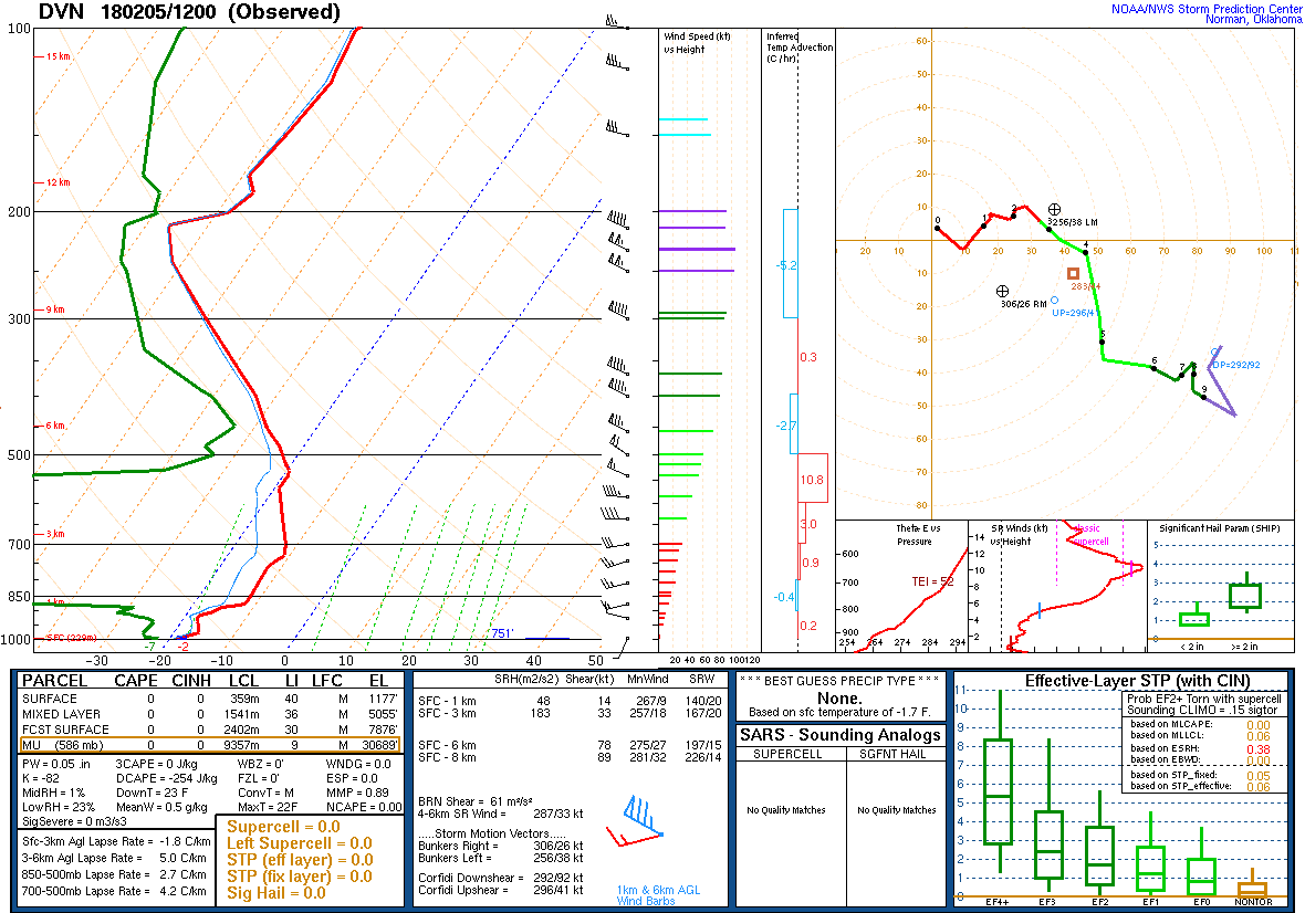
Environment
 |
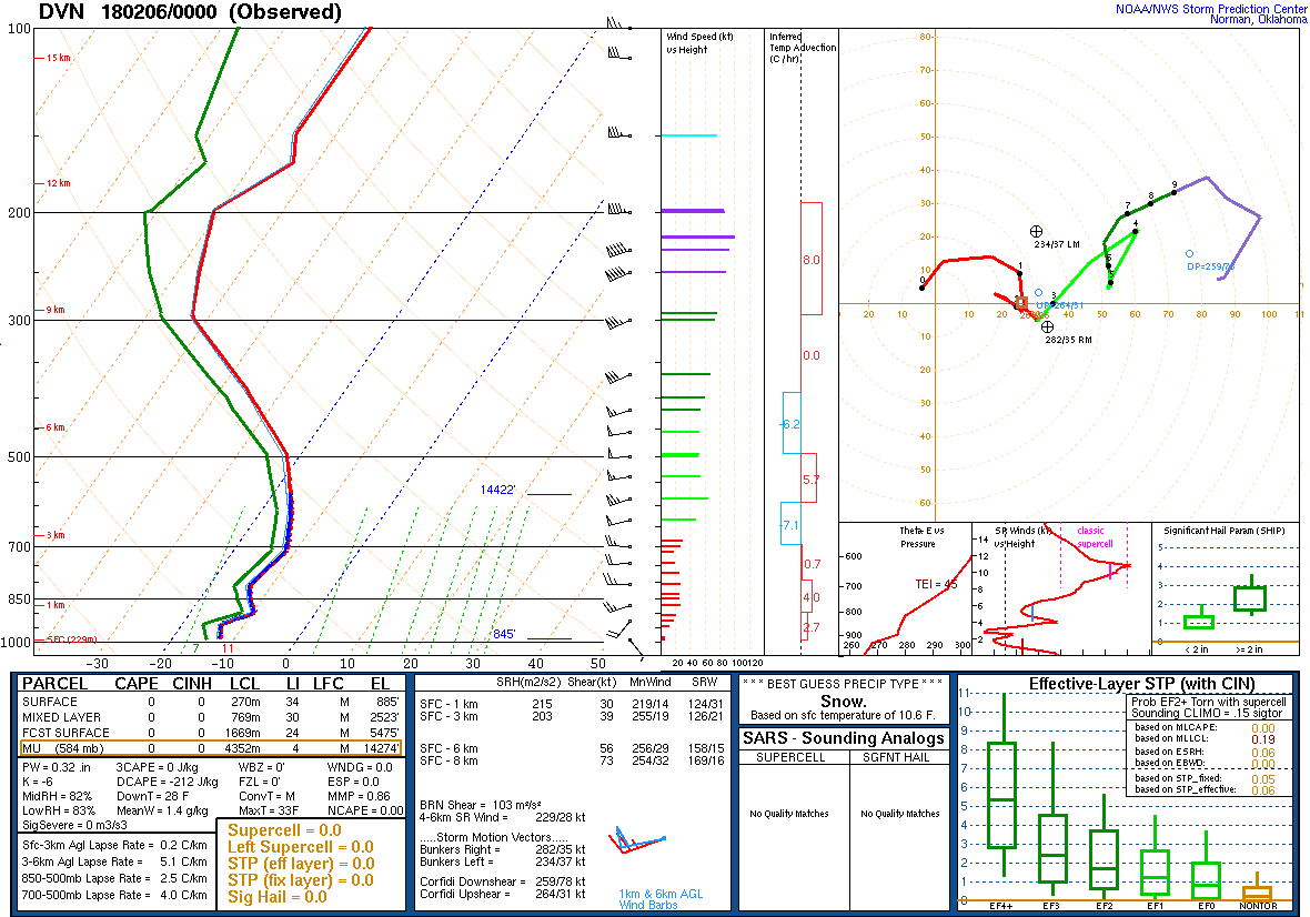 |
| Figure 2: 12Z 2/5 DVN Sounding | Figure 3: 00z 2/6 Sounding |
 |
Media use of NWS Web News Stories is encouraged! Please acknowledge the NWS as the source of any news information accessed from this site. |