Catastrophic Super Typhoon Bavi's eyewall has reached Rota and is expected to bring dangerous winds, heavy rainfall and storm surge to Guam, Rota, Tinian and Saipan. A Typhoon Warning remains in effect. Heavy to excessive rainfall will continue to bring a flooding threat from coastal Mid-Atlantic to southern New England through Monday. Read More >
Overview
|
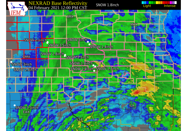
February 4, 2021 A fast moving Arctic cold front brought dangerous conditions to portions of the area Feb. 4. Rain, mixed with freezing rain and sleet moved into eastern Iowa during the early morning, then as a cold front moved in from the west during the mid morning, the rain switched to snow. Strong winds and falling temperatures behind the front caused wet roads to quickly freeze. Snow fell for several hours after the change over and became heavy at times, with widespread 2 to 6 inches of snowfall. Winds behind the front were 25 to 35 mph with gusts up to 45 mph during the afternoon and evening causing blowing snow in open areas. White out conditions were seen in open areas, and some areas experienced periods of near blizzard conditions, especially across east central and northeast Iowa. Significant drifting snow continued into Feb. 5. Wind chills dropped to 5 below to 15 below zero late Thursday night and Friday morning along and north of I-80 Official National Weather Service Observations
|
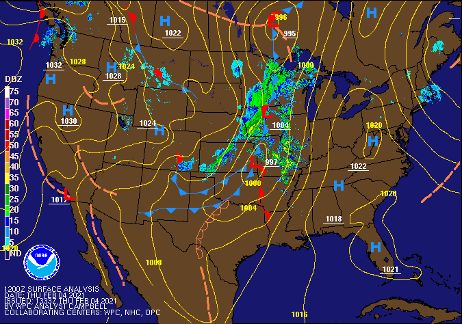 WPC - Surface Map and Radar Loop |
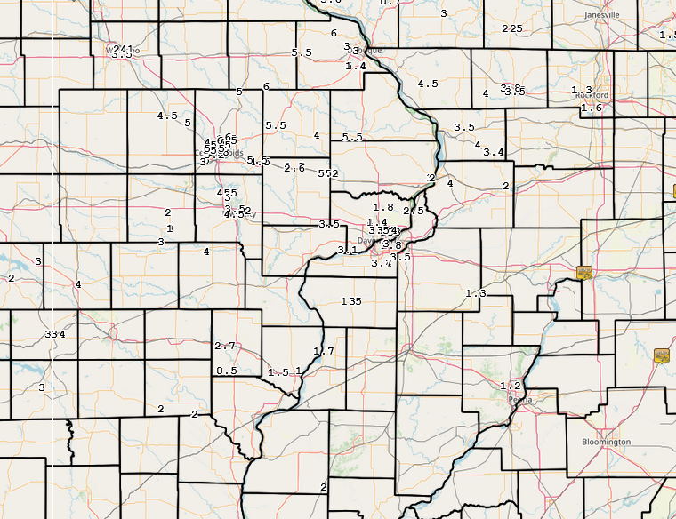
Snowfall Amounts
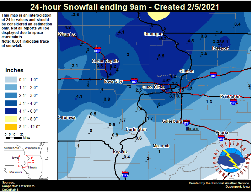 |
24 hour snow fall in inches,
for eastern Iowa, northwest and west central Illinois,
and northeast Missouri. Reported between Midnight and 9 AM,
Friday February 05, 2021.

....IOWA....
Ely 0.5 SE                        6.2
Rickardsville 0.2 W               6.0
Maquoketa                         5.5
Dubuque Arpt                      5.2
Bellevue LD12                     5.0
Dubuque LD11                      5.0
Waterloo ASOS                     4.8
Davenport 0.9 WNW                 4.6
Davenport Arpt                    4.6
Park View 0.2 WSW                 4.2
Manchester                        4.1
Sigourney                         4.1
Toledo 3 N                        4.0
Mount Auburn 2.2 NNW              4.0
Mason City 1 NNE                  4.0
Wellman 4.0 E                     4.0
North Liberty 0.7 SSW             4.0
Guttenberg Dam 10                 4.0
Williamsburg                      4.0
Solon 0.3 ESE                     4.0
Washington                        3.8
Tripoli 0 N                       3.6
Fairfax 4.0 NW                    3.5
Bettendorf 1.6 W                  3.4
Anamosa 3 SSW                     3.0
NWS Johnston* 5 NNW               3.0
Vinton                            3.0
Fayette 1 NW                      3.0
Parnell 0.1 SSW                   3.0
West Liberty 0.7 NNW              3.0
Muscatine 2.1 N                   2.5
Centerville 0 NE                  2.5
Perry 0 W                         2.4
Belle Plaine                      2.1
New London 1.5 SW                 1.7
Beaconsfield 1 NNE                1.4
Wapello 5.4 SE                    1.4
Ames US 30 2 SSE                  1.0
Donnellson                        0.9
Boone 1 SSW                       0.7
Salem 1S                          0.5
Fairfield                         0.5
Marshalltown 1 NW                 0.1
Keosauqua                         0.0
....ILLINOIS....
Freeport                          5.1
Elizabeth                         4.5
Romeoville                        4.4
Paw Paw 1 E                       4.2
Quad City Arpt                    3.7
Mount Carroll                     3.5
Coal Valley 1.9 SE                3.5
Winslow 4.3 ESE                   3.4
Stockton 3.4 NNE                  3.3
Freeport 2.0 NW                   3.2
Moline 0.7 NNE                    3.1
Aledo                             3.0
Geneseo 2.0 NW                    3.0
Freeport 1.7 NW                   3.0
Mundelein                         2.5
Augusta                           2.0
Mendota 2 SE                      2.0
Oquawka 0.5 N                     1.7
Rockford ASOS                     1.6
Coal Valley 2.6 E                 1.5
Kewanee 1 E                       1.3
Steward                           1.1
Princeton 1.1 SE                  1.0
Gladstone LD18                    1.0
Streator 3 SE                     1.0
Princeton                         1.0
Colchester 3.5 NE                 1.0
Dallas City 3.0 SSE               0.6
Warsaw 5.8 SE                     0.4
St Anne                           0.2
....MISSOURI....
Memphis                           1.0
Columbia                          0.0
....WISCONSIN....
Steuben 4SE 3 NE                  8.0
La Crosse WFO                     6.5
Viroqua                           5.8
Madison-ASOS                      3.5
Brodhead 1 SW                     3.4
Beloit-College                    3.0
Whitewater                        1.0
....MINNESOTA....
Preston                           5.0
Theilman 1SSW                     3.5
|
Storm Reports
February 4 Storm Reports
Courtesy IEM
|
|
PRELIMINARY LOCAL STORM REPORT...SUMMARY NATIONAL WEATHER SERVICE QUAD CITIES IA IL 854 PM CST THU FEB 4 2021 ..TIME... ...EVENT... ...CITY LOCATION... ...LAT.LON... ..DATE... ....MAG.... ..COUNTY LOCATION..ST.. ...SOURCE.... ..REMARKS.. 0332 PM SNOW 1 W MARION 42.03N 91.62W 02/04/2021 M6.5 INCH LINN IA BROADCAST MEDIA MEASURED ON GRILL. YARD MEASUREMENTS RANGED BETWEEN 2 AND 8 INCHES WITH DRIFTING. 0545 PM SNOW 2 NW MARION 42.05N 91.61W 02/04/2021 M6.0 INCH LINN IA TRAINED SPOTTER 0500 PM SNOW 1 S BUCK CREEK 42.31N 91.35W 02/04/2021 M6.0 INCH DELAWARE IA COCORAHS SNOWFALL IN THE PAST 8 HOURS. FREEZING RAIN/RAIN FOLLOWED BY SNOW. INTENSE SNOW DURING THE LATE MORNING AND EARLY AFTERNOON. STRONG WINDS MID-AFTERNOON CAUSING LOW VISIBILITY AND DRIFTING SNOW. 0721 PM SNOW 2 W CEDAR RAPIDS 41.98N 91.71W 02/04/2021 M5.8 INCH LINN IA TRAINED SPOTTER 0550 PM SNOW 1 ENE MOUNT VERNON 41.93N 91.41W 02/04/2021 M5.5 INCH LINN IA TRAINED SPOTTER SNOW IS ENDING, BUT BLOWING CONTINUES. 0514 PM SNOW 1 E DYERSVILLE 42.48N 91.10W 02/04/2021 M5.5 INCH DUBUQUE IA PUBLIC SOCIAL MEDIA REPORT. 0407 PM SNOW 2 NW CEDAR RAPIDS 41.99N 91.70W 02/04/2021 M5.5 INCH LINN IA PUBLIC SOCIAL MEDIA REPORT. 0336 PM SNOW ANAMOSA 42.11N 91.28W 02/04/2021 M5.5 INCH JONES IA PUBLIC HEAVY WET SNOW IS STARTING TO FREEZE. 0220 PM SNOW 3 NNE CEDAR RAPIDS 42.01N 91.66W 02/04/2021 E5.5 INCH LINN IA TRAINED SPOTTER AVERAGE SNOWFALL, VERY LIGHT SNOW FALLING, CONSIDERABLE DRIFTING IS OCCURRING. 0804 PM SNOW LOWDEN 41.86N 90.92W 02/04/2021 M5.2 INCH CEDAR IA CO-OP OBSERVER STORM TOTAL. 0600 PM SNOW 1 NW DUBUQUE REGIONAL A 42.41N 90.73W 02/04/2021 M5.2 INCH DUBUQUE IA OFFICIAL NWS OBS STORM TOTAL SO FAR AS OF 6 PM. 3.8 INCHES OF TOTAL FELL SINCE 12 PM TODAY. 0715 PM SNOW 2 NNW NORTH LIBERTY 41.76N 91.62W 02/04/2021 M5.0 INCH JOHNSON IA TRAINED SPOTTER STORM TOTAL SNOW. 0542 PM SNOW 1 NE FAIRFAX 41.93N 91.76W 02/04/2021 M5.0 INCH LINN IA TRAINED SPOTTER 0429 PM SNOW 1 W MARION 42.03N 91.60W 02/04/2021 M5.0 INCH LINN IA BROADCAST MEDIA 11 INCH SNOW DRIFTS. 0317 PM SNOW 2 NNW SHELLSBURG 42.12N 91.89W 02/04/2021 E5.0 INCH BENTON IA TRAINED SPOTTER STILL SNOWING - SIGNIFICANT BLOWING AND DRIFTING WITH VISIBILITY 1/2 TO 3/4 MILES. 0233 PM SNOW COGGON 42.28N 91.53W 02/04/2021 E5.0 INCH LINN IA PUBLIC SOCIAL MEDIA REPORT. 0600 PM SNOW DAVENPORT MUNICIPALITY 41.61N 90.58W 02/04/2021 M4.6 INCH SCOTT IA OFFICIAL NWS OBS STORM TOTAL SO FAR. 3.2 INCHES OF TOTAL FELL SINCE 12 PM TODAY. 0643 PM SNOW LISBON 41.92N 91.39W 02/04/2021 M4.5 INCH LINN IA TRAINED SPOTTER 0452 PM SNOW VINTON 42.16N 92.03W 02/04/2021 M4.5 INCH BENTON IA PUBLIC SOCIAL MEDIA REPORT. 0430 PM SNOW 1 SW UNIVERSITY HEIGHTS 41.65N 91.57W 02/04/2021 M4.5 INCH JOHNSON IA TRAINED SPOTTER 0219 PM SNOW 2 SSW HIAWATHA 42.02N 91.70W 02/04/2021 M4.5 INCH LINN IA TRAINED SPOTTER 0609 PM SNOW PEARL CITY 42.27N 89.83W 02/04/2021 E4.0 INCH STEPHENSON IL PUBLIC SOCIAL MEDIA REPORT. 0605 PM SNOW IOWA CITY 41.66N 91.54W 02/04/2021 M4.0 INCH JOHNSON IA TRAINED SPOTTER AT 6 PM MEASUREMENTS RANGED FROM 1 INCH TO 18 INCHES DUE TO BLOWING AND DRIFTING. 0437 PM SNOW CHADWICK 42.01N 89.89W 02/04/2021 M4.0 INCH CARROLL IL TRAINED SPOTTER 0315 PM SNOW WYOMING 42.06N 91.00W 02/04/2021 E4.0 INCH JONES IA TRAINED SPOTTER 0620 PM SNOW 2 WNW FREEPORT 42.30N 89.66W 02/04/2021 M3.8 INCH STEPHENSON IL TRAINED SPOTTER 0600 PM SNOW 3 SW QUAD CITY AIRPORT 41.40N 90.55W 02/04/2021 M3.7 INCH ROCK ISLAND IL OFFICIAL NWS OBS STORM TOTAL SO FAR AS OF 6 PM. 2.3 INCHES OF TOTAL FELL SINCE 12 PM TODAY. 0540 PM SNOW 2 ENE DAVENPORT 41.57N 90.57W 02/04/2021 M3.5 INCH SCOTT IA NWS EMPLOYEE 0504 PM SNOW 2 N UNIVERSITY HEIGHTS 41.68N 91.56W 02/04/2021 M3.5 INCH JOHNSON IA PUBLIC SOCIAL MEDIA REPORT. 0353 PM SNOW FREEPORT 42.28N 89.63W 02/04/2021 M3.5 INCH STEPHENSON IL TRAINED SPOTTER STILL LIGHTLY SNOWING. 0624 PM SNOW 2 W BETTENDORF 41.57N 90.51W 02/04/2021 M3.4 INCH SCOTT IA NWS EMPLOYEE 0540 PM SNOW MILLEDGEVILLE 41.97N 89.78W 02/04/2021 M3.4 INCH CARROLL IL TRAINED SPOTTER 0417 PM SNOW 2 WSW CEDAR RAPIDS 41.96N 91.70W 02/04/2021 M3.2 INCH LINN IA TRAINED SPOTTER SNOW HAS ENDED - BLOWING AND DRIFTING CONTINUE. 0438 PM SNOW 1 ENE MONTPELIER 41.47N 90.78W 02/04/2021 M3.1 INCH SCOTT IA TRAINED SPOTTER 0810 PM SNOW FAIRFAX 41.92N 91.78W 02/04/2021 E3.0 INCH LINN IA PUBLIC SOCIAL MEDIA REPORT. 0440 PM SNOW 2 NW MOLINE 41.50N 90.52W 02/04/2021 E3.0 INCH ROCK ISLAND IL TRAINED SPOTTER BLOWING SNOW. 0427 PM SNOW PARNELL 41.58N 92.01W 02/04/2021 M3.0 INCH IOWA IA TRAINED SPOTTER 0357 PM SNOW 1 W BETTENDORF 41.56N 90.49W 02/04/2021 E3.0 INCH SCOTT IA TRAINED SPOTTER SNOW IS MAINLY BLOWING AT THIS POINT - NO LONGER FALLING. 0332 PM SNOW 1 E CLINTON 41.84N 90.22W 02/04/2021 M3.0 INCH CLINTON IA TRAINED SPOTTER 0304 PM SNOW 1 NW CENTER GROVE 42.49N 90.73W 02/04/2021 M3.0 INCH DUBUQUE IA TRAINED SPOTTER HEAVY WET SNOW. SOME BLOWING AROUND AND SLICK ROADS. 0300 PM SNOW NORTH ENGLISH 41.51N 92.07W 02/04/2021 M3.0 INCH IOWA IA TRAINED SPOTTER STILL SNOWING. 0230 PM SNOW NORTH LIBERTY 41.74N 91.61W 02/04/2021 M3.0 INCH JOHNSON IA PUBLIC SOCIAL MEDIA REPORT. LIMITED VISIBILITY NOTED. 1206 PM SNOW LORE 42.51N 90.79W 02/04/2021 M3.0 INCH DUBUQUE IA TRAINED SPOTTER 0336 PM SNOW 1 NNE MOLINE 41.49N 90.48W 02/04/2021 M2.8 INCH ROCK ISLAND IL NWS EMPLOYEE 1157 AM SNOW CEDAR RAPIDS 41.97N 91.67W 02/04/2021 M2.8 INCH LINN IA BROADCAST MEDIA 0246 PM SNOW 2 NNW OAKLAND MILLS 40.97N 91.63W 02/04/2021 M2.7 INCH HENRY IA TRAINED SPOTTER 0609 PM SNOW STANWOOD 41.89N 91.15W 02/04/2021 M2.6 INCH CEDAR IA TRAINED SPOTTER SNOW HAS ENDED - WINDS CONTINUE. 0812 PM SNOW 1 SSW CORDOVA 41.67N 90.33W 02/04/2021 M2.5 INCH ROCK ISLAND IL TRAINED SPOTTER DIFFICULT TO MEASURE DUE TO BLOWING WIND. 0619 PM SNOW 3 ENE CHARLIE HEATH MEM 40.61N 91.84W 02/04/2021 E2.0 INCH CLARK MO TRAINED SPOTTER SNOW HAS ENDED - APPROXIMATE STORM TOTAL 2 INCHES WITH 15 INCH DRIFTS. 0442 PM SNOW STERLING 41.80N 89.69W 02/04/2021 M2.0 INCH WHITESIDE IL BROADCAST MEDIA 0439 PM SNOW 2 E CLINTON 41.84N 90.20W 02/04/2021 E2.0 INCH CLINTON IA PUBLIC SOCIAL MEDIA REPORT. 0349 PM SNOW CANTRIL 40.64N 92.07W 02/04/2021 E2.0 INCH VAN BUREN IA TRAINED SPOTTER SNOW APPEARS TO HAVE ENDED, BUT LOTS OF BLOWING AND DRIFTING CONTINUES. 1230 PM SNOW 4 ENE IOWA CITY 41.67N 91.47W 02/04/2021 M2.0 INCH JOHNSON IA TRAINED SPOTTER GUSTY WINDS AND STARTING TO DRIFT. 1116 AM SNOW 1 SW WILLIAMSBURG 41.66N 92.02W 02/04/2021 M2.0 INCH IOWA IA TRAINED SPOTTER LOW VISIBILITY WITH BLOWING SNOW. 1144 AM SNOW PARK VIEW 41.69N 90.54W 02/04/2021 M1.8 INCH SCOTT IA NWS EMPLOYEE STILL SNOWING. 0337 PM SNOW OQUAWKA 40.94N 90.95W 02/04/2021 M1.7 INCH HENDERSON IL TRAINED SPOTTER STORM TOTAL - BOTTOM HALF OF MEASUREMENT IS SLUSH. 0511 PM SNOW MIDDLETOWN 40.83N 91.26W 02/04/2021 M1.5 INCH DES MOINES IA PUBLIC SOCIAL MEDIA REPORT. 1251 PM SNOW 1 WNW ALEDO 41.20N 90.76W 02/04/2021 M1.5 INCH MERCER IL TRAINED SPOTTER SNOW AND SLEET,. 1043 AM SNOW 1 WNW MARION 42.04N 91.62W 02/04/2021 M1.3 INCH LINN IA TRAINED SPOTTER STILL SNOWING. 0644 PM SNOW 2 N BURLINGTON 40.84N 91.12W 02/04/2021 M1.0 INCH DES MOINES IA TRAINED SPOTTER |
|
|
Peak Wind Gusts 2/4/2021
Public Information Statement National Weather Service Quad Cities IA IL 405 AM CST Fri Feb 5 2021 ...HIGHEST WIND GUSTS OVER THE PAST 24 HOURS... Observations are collected from a variety of sources with varying equipment and exposures. We thank all volunteer weather observers for their dedication. Not all data listed are considered official. Location Speed Time/Date Lat/Lon/Elev (ft.) Washington Arpt 53 MPH 0135 PM 02/04 41.27N/91.67W/745 Quad City Intl Arpt 53 MPH 0752 PM 02/04 41.45N/90.52W/584 Iowa City Arpt 52 MPH 0252 PM 02/04 41.63N/91.55W/660 Biggsville 51 MPH 0644 PM 02/04 40.94N/90.85W/714 Cedar Rapids Arpt 51 MPH 0352 PM 02/04 41.88N/91.72W/840 Cedar Rapids Airport 51 MPH 0325 PM 02/04 41.88N/91.72W/839 Davenport Arpt 51 MPH 0452 PM 02/04 41.62N/90.58W/748 New London 50 MPH 0100 PM 02/04 40.97N/91.34W/813 Davenport Municipal Airport 49 MPH 0355 PM 02/04 41.61N/90.59W/741 Burlington Arpt 48 MPH 0153 PM 02/04 40.77N/91.13W/670 Moline Quad-City Airport 48 MPH 0852 PM 02/04 41.45N/90.52W/577 Macomb Arpt 48 MPH 0455 PM 02/04 40.52N/90.65W/680 Burlington Regional Airport 47 MPH 0437 PM 02/04 40.77N/91.13W/679 Fairfield Arpt 47 MPH 1255 PM 02/04 41.03N/91.97W/732 Iowa City Municipal Airport 47 MPH 0405 PM 02/04 41.64N/91.54W/649 Clinton Arpt 45 MPH 0456 PM 02/04 41.82N/90.32W/695 2 WNW Palisades State Park 45 MPH 0530 PM 02/04 41.93N/91.55W/774 Dubuque Arpt 44 MPH 0953 PM 02/04 42.40N/90.70W/1062 Dubuque Regional Airport 44 MPH 0900 PM 02/04 42.40N/90.71W/1040 Muscatine Arpt 44 MPH 0455 PM 02/04 41.37N/91.15W/541 Independence Arpt 43 MPH 0435 PM 02/04 42.45N/91.95W/969 Sterling/Rock Falls Arpt 43 MPH 0956 PM 02/04 41.75N/89.67W/644 Cedar Rapids 42 MPH 0637 PM 02/04 41.93N/91.62W/826 3 SE Maysville 42 MPH 0850 PM 02/04 41.60N/90.68W/675 Stockton 3 Nne 42 MPH 0900 PM 02/04 42.40N/90.00W/970 Stockton 41 MPH 0935 PM 02/04 42.40N/89.99W/974 Fort Madison Arpt 41 MPH 0455 PM 02/04 40.67N/91.32W/686 1 NNE Aurora 40 MPH 0510 PM 02/04 42.64N/91.72W/1151 Stanley 40 MPH 0715 PM 02/04 42.64N/91.81W/1118 Monticello Arpt 40 MPH 0415 PM 02/04 42.22N/91.17W/817 0.6 W Lowden (UPR) 40 MPH 0345 PM 02/04 41.86N/90.93W/720 |
|
|
 |
Media use of NWS Web News Stories is encouraged! Please acknowledge the NWS as the source of any news information accessed from this site. |
|