Showers and thunderstorms will be possible from the northern Plains to the Gulf Coast on Monday. Thunderstorms with large hail and severe wind gusts are expected Monday afternoon and evening across parts of the central Plains. Read More >
Overview
|
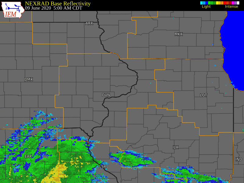
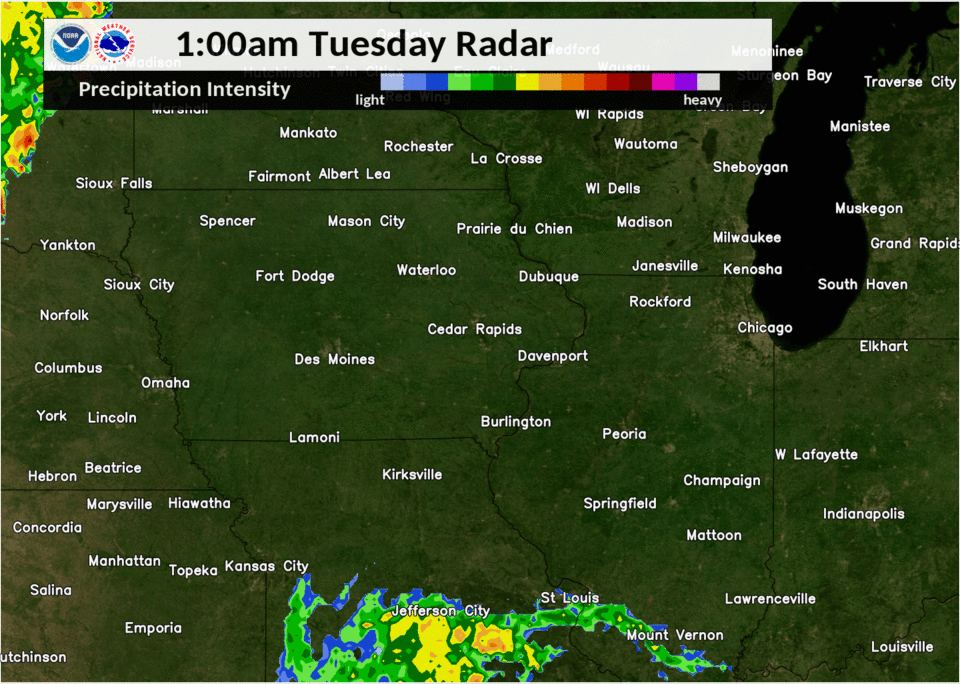
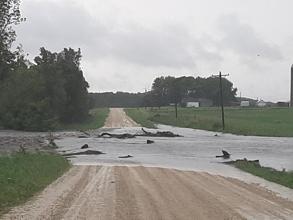
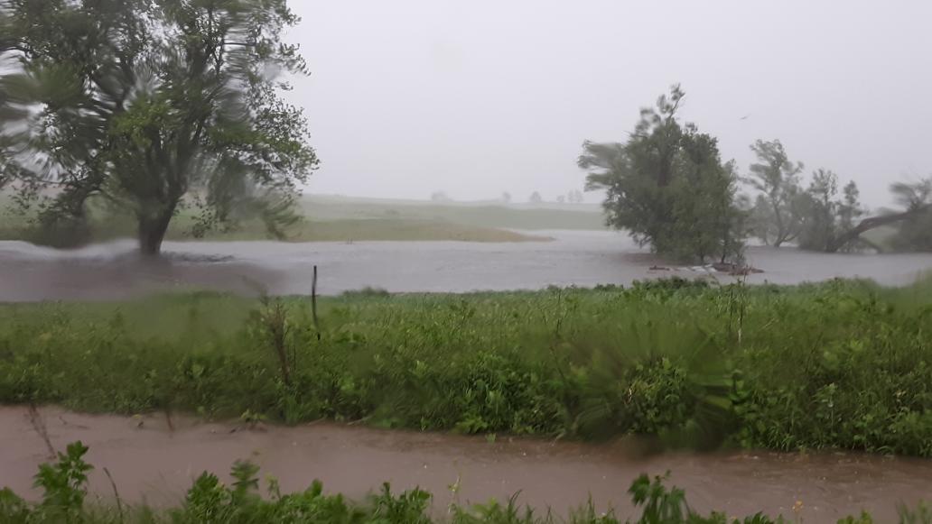
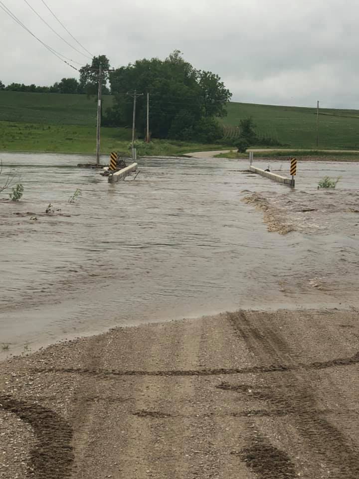
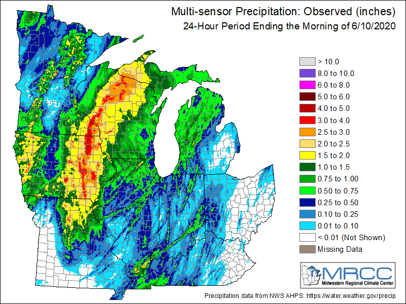
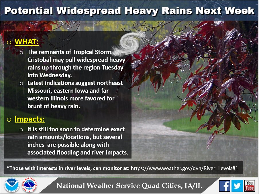
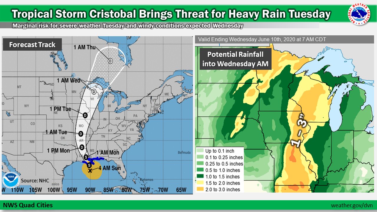
Tropical Depression Cristobal tacked across much of the mid and upper Mississippi River Valley on the morning and afternoon of June 9, 2020. Very high levels of moisture were brought in tow, bringing very heavy rainfall to much of the region, especially eastern Iowa. By the time it was said and done, rainfall amounts of 2 - 4 inches fell roughly west of a line from Keosauqua IA, to Burlington IA, to Guttenberg IA. Localized amounts of 4 - 5 inches were reported near Belle Plaine, IA. This torrential rainfall led to numerous reports of flooded roadways, road closures and creeks out of the their banks. In addition, area rivers also showed response, with some rising near to well above flood stage.
Surrounding Office Summaries |
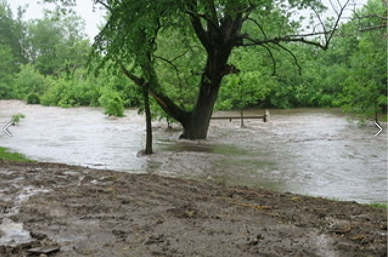
 Rock River Flooding : Courtesy Whiteside County Emergency Management |
Flooding
*This page will receive more updates in the coming days*
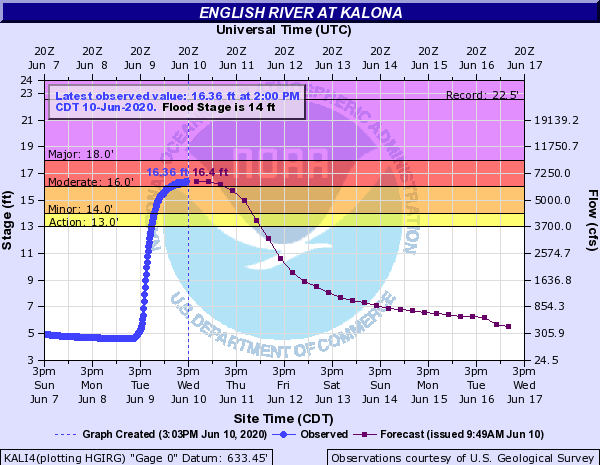
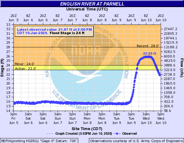
Hydrographs
| RIVERS THAT ROSE IN RESPONSE TO CRISTOBAL | |||
 |
 |
 |
|
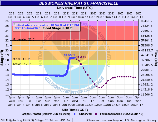
| English River - Kalona, IA | English River - Parnell, IA | Des Moines River - St. Francisville, IA | |
Photos/Video
*This page will receive more updates in the coming days*
 |
 |
 |
 |
| Buffalo Creek near Hazelton/Olewein, IA (Danny Murphy) |
Buffalo Creek near Hazelton/Olewein, IA (Danny Murphy) |
Honey Creek near Koszta, IA |
Silver Creek near Covington, IA |
Storm/Flood Reports
 |
| Interactive Map Link |
PRELIMINARY LOCAL STORM REPORT...SUMMARY
NATIONAL WEATHER SERVICE QUAD CITIES IA IL
901 PM CDT TUE JUN 9 2020

..TIME...   ...EVENT...      ...CITY LOCATION...     ...LAT.LON...
..DATE...   ....MAG....      ..COUNTY LOCATION..ST.. ...SOURCE....
            ..REMARKS..

0802 PM     HEAVY RAIN       NAUVOO                  40.55N 91.39W
06/09/2020  M1.75 INCH       HANCOCK            IL   TRAINED SPOTTER


0726 PM     HEAVY RAIN       2 NE FORT MADISON       40.64N 91.34W
06/09/2020  M1.70 INCH       LEE                IA   TRAINED SPOTTER


0724 PM     HEAVY RAIN       MEDIAPOLIS              41.01N 91.16W
06/09/2020  M2.00 INCH       DES MOINES         IA   TRAINED SPOTTER


0723 PM     FLOOD            1 ESE VINTON            42.16N 92.01W
06/09/2020                   BENTON             IA   LAW ENFORCEMENT

            LAW ENFORCEMENT REPORTED STREET FLOODING IN
            THE CITY OF VINTON.

0711 PM     HEAVY RAIN       1 N INDEPENDENCE        42.48N 91.89W
06/09/2020  M3.92 INCH       BUCHANAN           IA   PUBLIC


0710 PM     HEAVY RAIN       4 W STANLEY             42.63N 91.86W
06/09/2020  M4.60 INCH       BUCHANAN           IA   CO-OP OBSERVER


0710 PM     HEAVY RAIN       HOPKINTON               42.35N 91.25W
06/09/2020  M2.30 INCH       DELAWARE           IA   PUBLIC

            .

0709 PM     HEAVY RAIN       1 NE FAIRFAX            41.93N 91.76W
06/09/2020  M2.25 INCH       LINN               IA   PUBLIC


0657 PM     HEAVY RAIN       2 SE IOWA CITY          41.64N 91.51W
06/09/2020  M1.90 INCH       JOHNSON            IA   TRAINED SPOTTER

            TOTAL.

0650 PM     HEAVY RAIN       JESUP                   42.48N 92.07W
06/09/2020  M2.69 INCH       BUCHANAN           IA   PUBLIC

            .

0649 PM     HEAVY RAIN       1 S MOUNT PLEASANT MUNI 40.93N 91.51W
06/09/2020  M2.10 INCH       HENRY              IA   PUBLIC


0638 PM     HEAVY RAIN       1 E INDEPENDENCE        42.47N 91.88W
06/09/2020  M3.00 INCH       BUCHANAN           IA   TRAINED SPOTTER

            UPDATES PREVIOUS HEAVY RAIN REPORT FROM 1 E
            INDEPENDENCE. TOTAL.

0635 PM     HEAVY RAIN       2 NNW NORTH LIBERTY     41.76N 91.62W
06/09/2020  M3.48 INCH       JOHNSON            IA   TRAINED SPOTTER

            .

0634 PM     HEAVY RAIN       2 NNE STONE CITY        42.14N 91.33W
06/09/2020  M3.75 INCH       JONES              IA   TRAINED SPOTTER

            .

0633 PM     HEAVY RAIN       4 ESE ALBURNETT         42.14N 91.55W
06/09/2020  M2.15 INCH       LINN               IA   TRAINED SPOTTER


0630 PM     FLOOD            5 S VINTON              42.09N 92.02W
06/09/2020                   BENTON             IA   LAW ENFORCEMENT

            WATER COMPLETELY OVER THE ROAD AT 64TH ST
            AND 24TH AVE. ROAD HAS BEEN CLOSED.

0629 PM     HEAVY RAIN       3 SW CENTER JUNCTION    42.08N 91.11W
06/09/2020  M2.67 INCH       JONES              IA   TRAINED SPOTTER


0629 PM     HEAVY RAIN       3 NNE CEDAR RAPIDS      42.01N 91.66W
06/09/2020  M2.62 INCH       LINN               IA   TRAINED SPOTTER

            .

0629 PM     HEAVY RAIN       1 NE FAIRFAX            41.93N 91.76W
06/09/2020  E1.90 INCH       LINN               IA   TRAINED SPOTTER

            .

0628 PM     HEAVY RAIN       2 SSW LADORA            41.72N 92.20W
06/09/2020  E4.51 INCH       IOWA               IA   TRAINED SPOTTER

            .

0625 PM     HEAVY RAIN       3 ENE MARION            42.05N 91.54W
06/09/2020  M1.93 INCH       LINN               IA   TRAINED SPOTTER


0625 PM     HEAVY RAIN       1 SW WILLIAMSBURG       41.65N 92.02W
06/09/2020  M2.98 INCH       IOWA               IA   TRAINED SPOTTER

            .

0623 PM     HEAVY RAIN       3 NNW SHELLSBURG        42.12N 91.89W
06/09/2020  E2.41 INCH       BENTON             IA   TRAINED SPOTTER

            PONDING IN FIELDS AND DITCHES.

0605 PM     HEAVY RAIN       1 N OAKDALE             41.71N 91.59W
06/09/2020  M3.45 INCH       JOHNSON            IA   TRAINED SPOTTER

            TOTAL.

0605 PM     HEAVY RAIN       2 SW CEDAR RAPIDS       41.95N 91.71W
06/09/2020  M2.67 INCH       LINN               IA   TRAINED SPOTTER


0600 PM     HEAVY RAIN       1 ESE MUSCATINE         41.41N 91.06W
06/09/2020  M1.75 INCH       MUSCATINE          IA   TRAINED SPOTTER

            .

0551 PM     HEAVY RAIN       2 ESE FAIRVIEW          42.08N 91.30W
06/09/2020  M2.78 INCH       JONES              IA   TRAINED SPOTTER


0546 PM     HEAVY RAIN       1 W COU FALLS           41.82N 91.69W
06/09/2020  M3.00 INCH       JOHNSON            IA   TRAINED SPOTTER

            TOTAL.

0545 PM     HEAVY RAIN       2 ESE FAIRVIEW          42.08N 91.30W
06/09/2020  E2.78 INCH       JONES              IA   TRAINED SPOTTER

            .

0545 PM     HEAVY RAIN       BELLE PLAINE            41.90N 92.28W
06/09/2020  E4.25 INCH       BENTON             IA   TRAINED SPOTTER


0530 PM     HEAVY RAIN       2 E IOWA CITY           41.66N 91.49W
06/09/2020  M2.85 INCH       JOHNSON            IA   TRAINED SPOTTER

            EVENT TOTAL.

0530 PM     HEAVY RAIN       PARNELL                 41.59N 92.00W
06/09/2020  M2.55 INCH       IOWA               IA   TRAINED SPOTTER

            .

0530 PM     HEAVY RAIN       3 ENE CHARLIE HEATH MEM 40.61N 91.84W
06/09/2020  M2.70 INCH       VAN BUREN          IA   TRAINED SPOTTER

            UPDATES PREVIOUS HEAVY RAIN REPORT FROM 3
            ENE CHARLIE HEATH MEMORIAL. TOTAL.

0525 PM     HEAVY RAIN       4 N MARENGO             41.85N 92.07W
06/09/2020  M3.33 INCH       IOWA               IA   TRAINED SPOTTER


0520 PM     HEAVY RAIN       2 SSW WILLIAMSTOWN      41.54N 91.74W
06/09/2020  M2.78 INCH       JOHNSON            IA   TRAINED SPOTTER

            .

0510 PM     HEAVY RAIN       3 NNE CEDAR RAPIDS      42.01N 91.66W
06/09/2020  M2.55 INCH       LINN               IA   TRAINED SPOTTER

            UPDATES PREVIOUS HEAVY RAIN REPORT FROM 3
            NNE CEDAR RAPIDS. TOTAL.

0509 PM     HEAVY RAIN       1 E INDEPENDENCE        42.47N 91.88W
06/09/2020  M2.25 INCH       BUCHANAN           IA   TRAINED SPOTTER

            SO FAR.
Rainfall Amounts
 |
 |
 |
 |
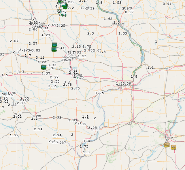
| Figure 1 Local 24-hr Rainfall Ending 6/10/20 |
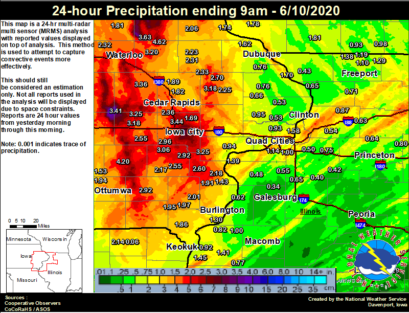
Figure 2 Regional 24-hr Precipitation Ending 6/10/20 |
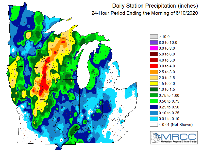
Figure 3 6/10/20 |
Figure 4 Local COOP Observer 48 hour Rainfall Ending 9 AM 6/11 |
Additional Information
The Forecast
 |
 |
 |
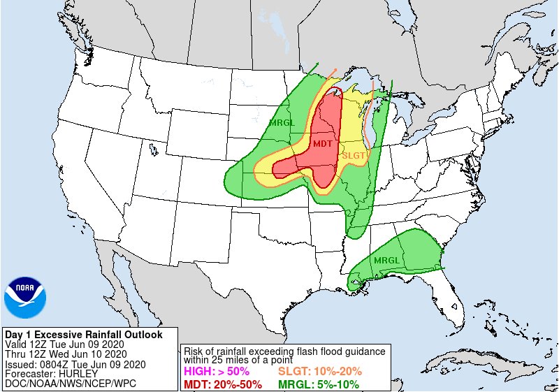 |
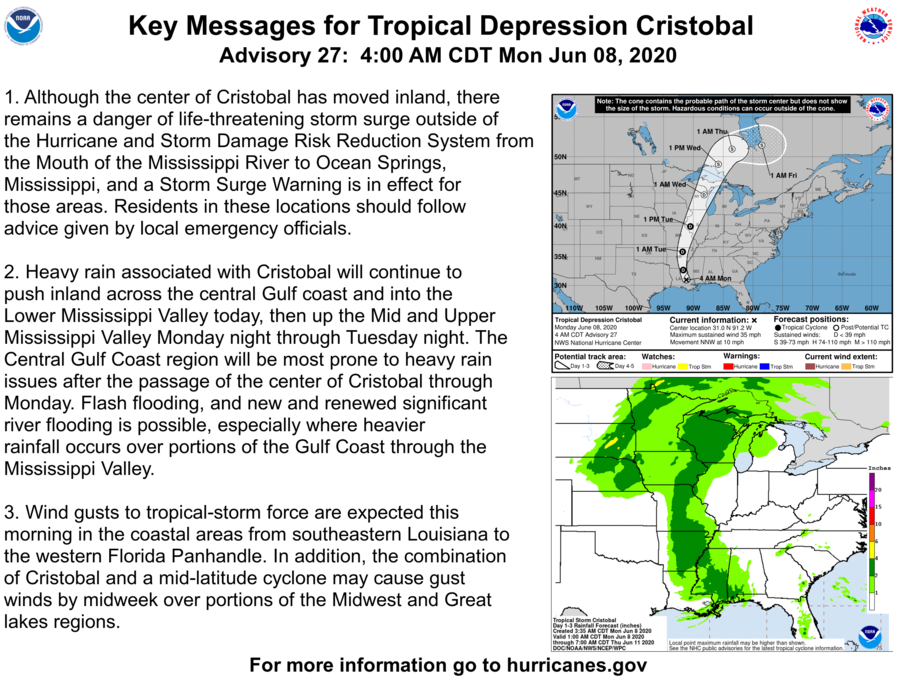
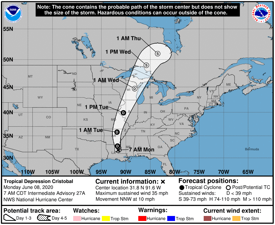
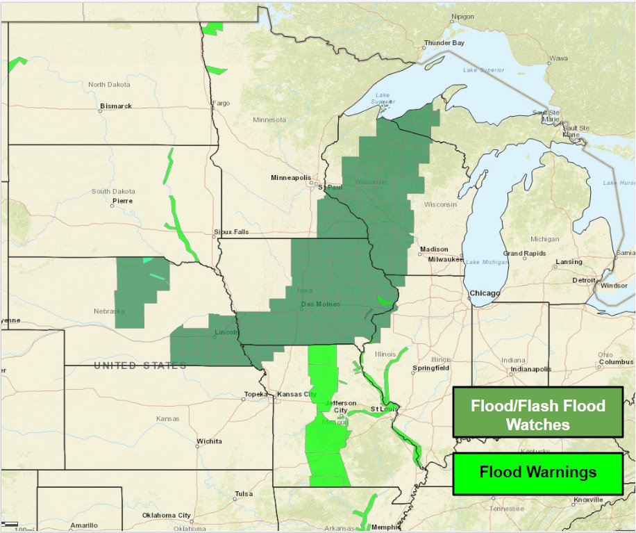
| National Hurricane Center Key Messages for June 8, 2020 | National Hurricane Center Forecast (public Advisory June 9, 2020 4 PM) | Flash Flood Watches in effect for June 9 (link to text) | WPC Excessive Rainfall Outlook June 9, 2020 |
 |
 |
 |
|
| DVN Weather Story June 5, 2020 | DVN Weather Story June 7, 2020 | DVN Weather Story June 9, 2020 |
 |
Media use of NWS Web News Stories is encouraged! Please acknowledge the NWS as the source of any news information accessed from this site. |
|