
Scattered severe thunderstorms capable of damaging wind gusts and some hail are expected this afternoon and evening from the Upper Ohio River Valley into the Northeast, and from the Appalachians into the Mid-Atlantic States. Excessive rainfall from heavy thunderstorms may produce areas of flash flooding from southern New Mexico into the western and northern Gulf Coast into Wednesday. Read More >
Overview
|
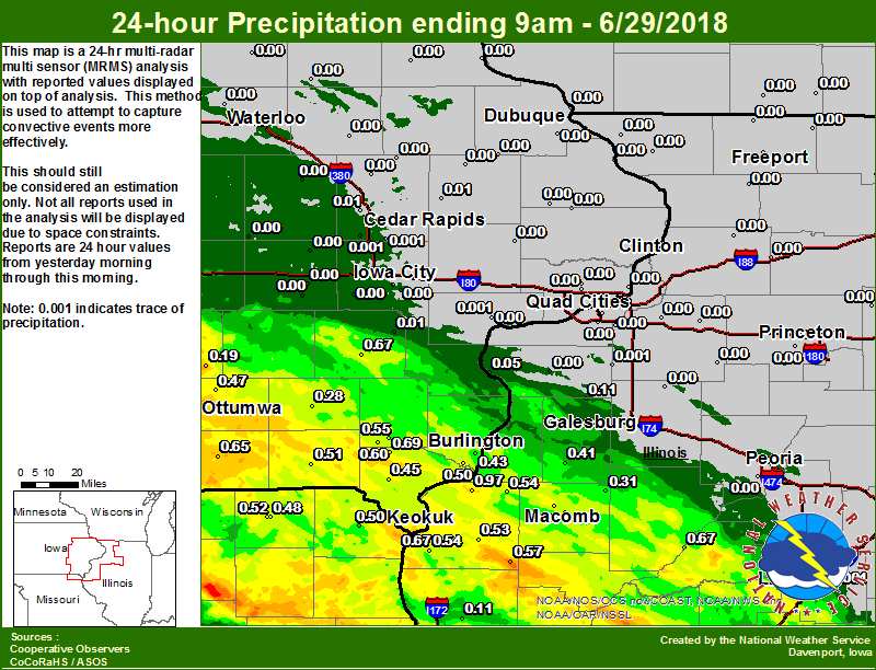
A cluster of storms moving from southern Iowa to southern Illinois produced severe weather on Thursday, June 28th. Strong winds downed trees and powerlines around Keokuk, Fort Madison, and Macomb, and one person was injured by a falling tree in Memphis. Rainfall amounts ranged from a trace at Cedar Rapids and Iowa City, to forty three hundredths of an inch at Burlington. It was warm with temperatures ranging from 88 degrees at Dubuque and Burlington, to 83 degrees at Freeport.
Additional Reports |
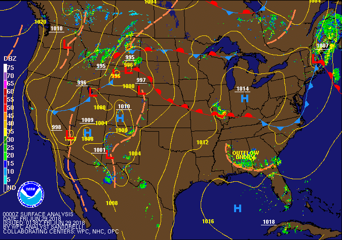 Weather Prediction Center Surface Pressure/Front/Radar Loop |
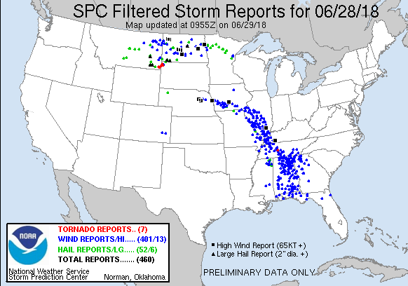
| Interactive Storm Reports Map | SPC STORM REPORTS |
 |
 |
|
PRELIMINARY LOCAL STORM REPORT...SUMMARY
NATIONAL WEATHER SERVICE QUAD CITIES IA IL
631 PM CDT THU JUN 28 2018

..TIME...   ...EVENT...      ...CITY LOCATION...     ...LAT.LON...
..DATE...   ....MAG....      ..COUNTY LOCATION..ST.. ...SOURCE....
            ..REMARKS..

0320 PM     TSTM WND DMG     MACOMB                  40.47N 90.68W
06/28/2018                   MCDONOUGH          IL   TRAINED SPOTTER

            NUMEROUS TREE LIMBS DOWN ON THE NORTH SIDE
            OF MACOMB. TIME ESTIMATED FROM RADAR.

0315 PM     HAIL             WASHINGTON              41.30N 91.69W
06/28/2018  E0.75 INCH       WASHINGTON         IA   TRAINED SPOTTER

            DELAYED REPORT. DIME SIZED HAIL.

0315 PM     TSTM WND DMG     AUGUSTA                 40.23N 90.95W
06/28/2018                   HANCOCK            IL   BROADCAST MEDIA

            TREE LIMBS DOWN FROM PUBLIC VIA WGEM. TIME
            APPROXIMATED.

0313 PM     TSTM WND DMG     RARITAN                 40.70N 90.82W
06/28/2018                   HENDERSON          IL   PUBLIC

            DELAYED REPORT VIA SOCIAL MEDIA. TIME
            ESTIMATED FROM RADAR. TREES AND TREE LIMBS
            DOWN.

0258 PM     TSTM WND DMG     BURLINGTON              40.81N 91.12W
06/28/2018                   DES MOINES         IA   EMERGENCY MNGR

            TREES DOWN.

0250 PM     TSTM WND DMG     ELVASTON                40.39N 91.25W
06/28/2018                   HANCOCK            IL   PUBLIC

            LARGE TREE LIMB DOWN, REPORT VIA SOCIAL
            MEDIA.

0247 PM     TSTM WND DMG     KEOKUK                  40.40N 91.39W
06/28/2018                   LEE                IA   PUBLIC

            LARGE TREE LIMB DOWN POSSIBLY 4 INCHES IN
            DIAMETER. TIME ESTIMATED FROM RADAR.

0245 PM     TSTM WND DMG     KEOKUK                  40.41N 91.40W
06/28/2018                   LEE                IA   TRAINED SPOTTER

            DELAYED REPORT AND TIME ESTIMATED. 1 AND 2
            INCH LIMBS DOWN. BASKETBALL HOOP AT HAWTHORN
            ELEMENTARY BENT.

0240 PM     TSTM WND DMG     FORT MADISON            40.62N 91.35W
06/28/2018                   LEE                IA   PUBLIC

            TREE LIMBS AND WIRES DOWN ON AVENUE F.

0240 PM     TSTM WND GST     FORT MADISON            40.62N 91.35W
06/28/2018  E50 MPH          LEE                IA   EMERGENCY MNGR

            WIND SUSTAINED AT 20-25 MPH - GUSTS 50+ MPH.

0237 PM     TSTM WND DMG     1 ESE KEOKUK            40.40N 91.39W
06/28/2018                   LEE                IA   PUBLIC

            CORRECTS PREVIOUS TSTM WND DMG REPORT FROM 1
            ESE KEOKUK. 3 INCH LIMB BROKEN.

0233 PM     TSTM WND DMG     DENMARK                 40.75N 91.33W
06/28/2018                   LEE                IA   PUBLIC

            POWER LINES DOWN.

0224 PM     TSTM WND GST     3 WSW COPPOCK           41.15N 91.77W
06/28/2018  E45 MPH          JEFFERSON          IA   TRAINED SPOTTER

            WIND ESTIMATED 40-45 MPH.

0215 PM     TSTM WND DMG     3 ENE CHARLIE HEATH MEM 40.59N 91.84W
06/28/2018                   CLARK              MO   TRAINED SPOTTER

            TIME ESTIMATED. 12 INCH DIAMETER TREE DOWNED
            BY THUNDERSTORM WINDS.

0205 PM     TSTM WND GST     3 ENE CHARLIE HEATH MEM 40.59N 91.84W
06/28/2018  E60 MPH          CLARK              MO   TRAINED SPOTTER

            WINDS OCCURRED AROUND 205 PM.

0155 PM     TSTM WND DMG     MEMPHIS                 40.46N 92.17W
06/28/2018                   SCOTLAND           MO   BROADCAST MEDIA

            *** 1 INJ ***
            DELAYED REPORT AND TIME ESTIMATED FROM
            RADAR. WOMAN HOSPITALIZED FROM FALLING TREE.
            REPORTED BY WGEM.


&&
|
|
 |
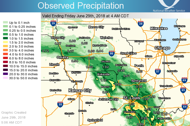 |
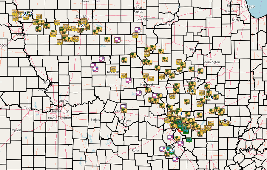
| Local Rainfall | Regional Rainfall |
24 hour precipitation reports (in Inches),
for eastern Iowa, northwest and west central Illinois,
and northeast Missouri. Reported between Midnight and 9 AM,
Friday June 29, 2018.

....IOWA....
West Point 7.5 NW                0.69
Washington                       0.67
Keokuk LD19                      0.67
Bloomfield 1 NW                  0.65
Salem 1S                         0.60
Salem 3.1 ESE                    0.55
Keosauqua                        0.51
Burlington 6.5 SSW               0.50
Ottumwa ASOS 6 NNW               0.47
Donnellson                       0.45
Burlington Arpt 2 SW             0.43
Oskaloosa 1 NNW                  0.32
Fairfield                        0.28
Rathbun Reservoir 2 N            0.28
Oskaloosa AWOS 9 ESE             0.19
Pella 4 N                        0.17
Brighton                         0.10
NWS Johnston* 5 NNW              0.04
Anamosa 3 SSW                    0.01
Ainsworth 7.4 N                  0.01
Cedar Rapids 3.4 NW              0.01
Muscatine 2N                     0.00
Cedar Rapids Arpt 5 SW           0.00
Boone 1 SSW                      0.00
Iowa City Arpt                   0.00
Toledo 3 N                       0.00
Ely 0.5 SE                       0.00
Marshalltown ASOS 4 N            0.00
Dubuque Arpt 7 SW                0.00
Quasqueton 0.5 W                 0.00
Davenport Arpt 5 N               0.00
Perry 0 W                        0.00
Beaconsfield 1 NNE               0.00
Lowden                           0.00
Bellevue LD12                    0.00
Mason City ASOS 6 W              0.00
Dubuque LD11                     0.00
Bettendorf 2.2 SE                0.00
Maquoketa 4W                     0.00
Central City 6.7 W               0.00
Cresco 1 NE                      0.00
Mason City 1 NNE                 0.00
Kalona 7.3 NNW                   0.00
Cascade                          0.00
Eldridge 0.7 SSW                 0.00
Iowa City                        0.00
Bettendorf 1.6 WSW               0.00
Elkader 6SSW                     0.00
Oelwein AWOS                     0.00
Le Claire LD14                   0.00
Pella AWOS 2 WSW                 0.00
Marshalltown 1 NW                0.00
Le Claire 1.8 NNE                0.00
Vinton                           0.00
Coggon                           0.00
Hampton 1 N                      0.00
Parnell 0.1 SSW                  0.00
Waterloo ASOS 5 NW               0.00
Guttenberg Dam 10                0.00
Monticello 1 E                   0.00
Amana 4.7 W                      0.00
Grinnell AWOS 2 SSW              0.00
Williamsburg                     0.00
Tripoli 0 N                      0.00
Davenport 0.9 SSW                0.00
Delmar 2.3 NW                    0.00
Belle Plaine                     0.00
....ILLINOIS....
Dallas City 3.0 SSE              0.97
Macomb                           0.88
Macomb 3.8 NW                    0.75
Havana                           0.67
Augusta                          0.57
Jacksonville AWOS                0.57
La Harpe                         0.54
Warsaw 5.8 SE                    0.54
Bentley                          0.53
Roseville 0.6 WNW                0.41
Prairie City 2S                  0.31
Colchester 3.5 NE                0.20
Quincy ASOS                      0.11
Alexis 1 SW                      0.11
New Boston LD17                  0.05
Windsor                          0.00
Decatur Airport                  0.00
New Windsor 2.0 N                0.00
Lincoln NWS                      0.00
Geneseo 2.0 NW                   0.00
Aledo                            0.00
Coleta 1.4 SSW                   0.00
Rockford ASOS                    0.00
Princeton 1.1 SE                 0.00
Mundelein                        0.00
Ottawa 4 SW                      0.00
Tiskilwa 2.1 N                   0.00
Freeport 2.0 NW                  0.00
Rock Falls                       0.00
Freeport 1.7 ESE                 0.00
Quad City Arpt 3 S               0.00
Romeoville                       0.00
Galesburg                        0.00
Rochelle AWOS                    0.00
Paw Paw 1 E                      0.00
Galena                           0.00
Mendota 2 SE                     0.00
Davis 0.5 N                      0.00
Freeport                         0.00
Ogden                            0.00
Moline 0.7 NNE                   0.00
Princeton                        0.00
Steward                          0.00
Peoria ASOS                      0.00
Kewanee 1 E                      0.00
Streator 3 SE                    0.00
Joliet                           0.00
Minonk                           0.00
Shannon 0.2 S                    0.00
St Anne                          0.00
Bloomington Airport              0.00
Elizabeth                        0.00
Tuscola                          0.00
Coal Valley 1.9 SE               0.00
Winslow 4.3 ESE                  0.00
Rochelle                         0.00
Roscoe 2SE                       0.00
Ill. City LD16 3 WNW             0.00
Galesburg Arpt 3 SW              0.00
Atkinson 2.6 NNE                 0.00
Altona                           0.00
....MISSOURI....
Kirksville ASOS                  0.58
Memphis                          0.52
Kahoka 0.6 S                     0.50
Memphis 0.1 S                    0.48
Chillicothe 2 NW                 0.00
Columbia                         0.00
....WISCONSIN....
Beloit-College                   0.01
Brodhead 1 SW                    0.00
Watertown-AWOS                   0.00
Allenton-WWTP .6 NW              0.00
Prairie du Chien AWOS            0.00
La Crosse WFO                    0.00
Monroe 1 W                       0.00
Madison-ASOS                     0.00
Viroqua                          0.00
....MINNESOTA....
Preston                          0.00
Theilman 1SSW                    0.00
|
|
 |
 |
 |
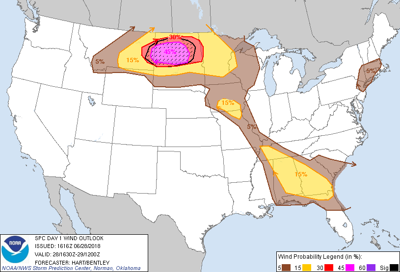 |
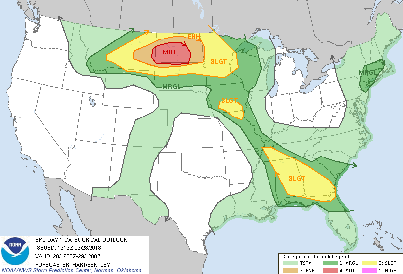
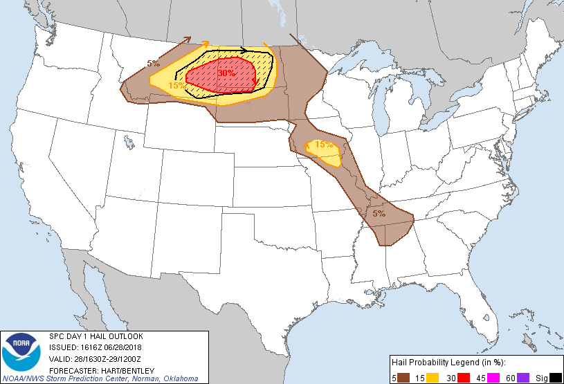
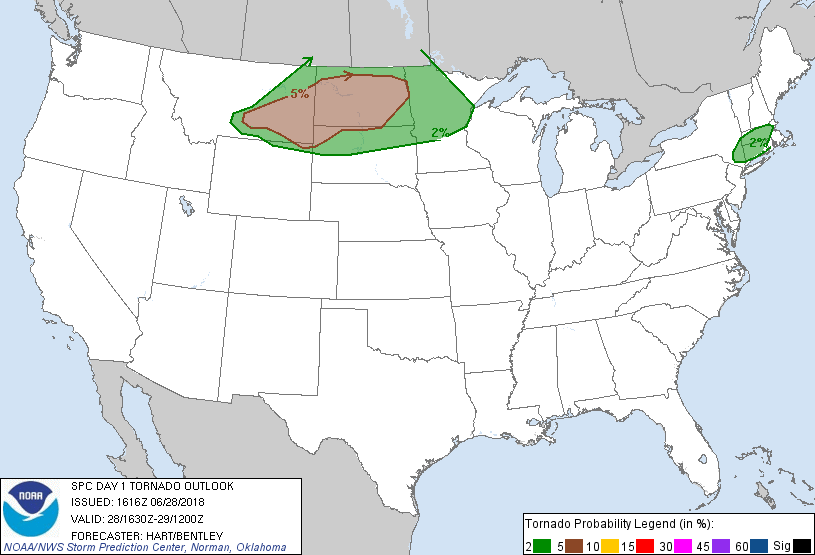
| Day 1 (1630z) | Day 1 Hail | Day 1 Tornado | Day 1 Wind |
 |
 |
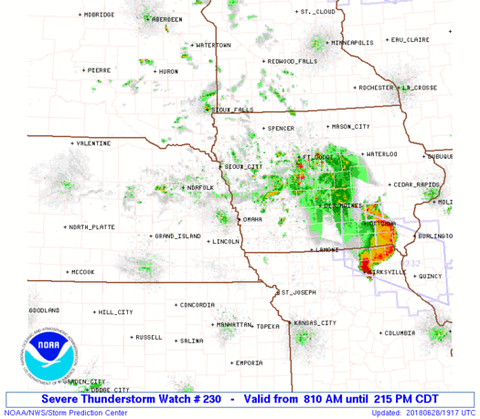 |
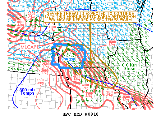
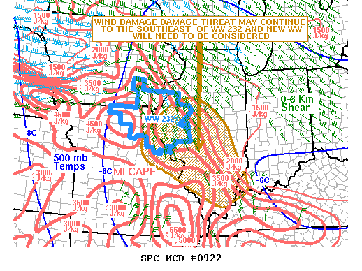
| MCD #0919 | MCD #0922 | Watch #0230 |
 |
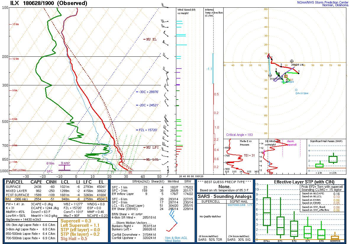 |
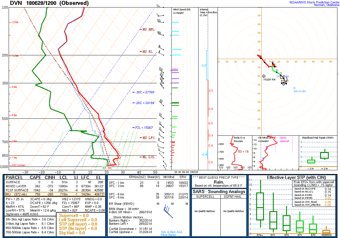
| Davenport 7 AM Sounding | Lincoln 2 PM Sounding |
 |
Media use of NWS Web News Stories is encouraged! Please acknowledge the NWS as the source of any news information accessed from this site. |
|


