Scattered severe thunderstorms capable of damaging wind gusts and some hail are expected this afternoon and evening from the Upper Ohio River Valley into the Northeast, and from the Appalachians into the Mid-Atlantic States. Excessive rainfall from heavy thunderstorms may produce areas of flash flooding from southern New Mexico into the western and northern Gulf Coast into Wednesday. Read More >
Overview
|
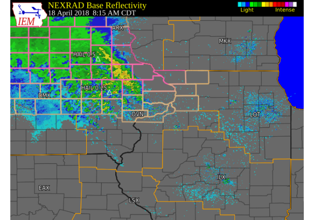
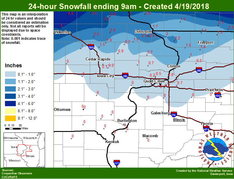
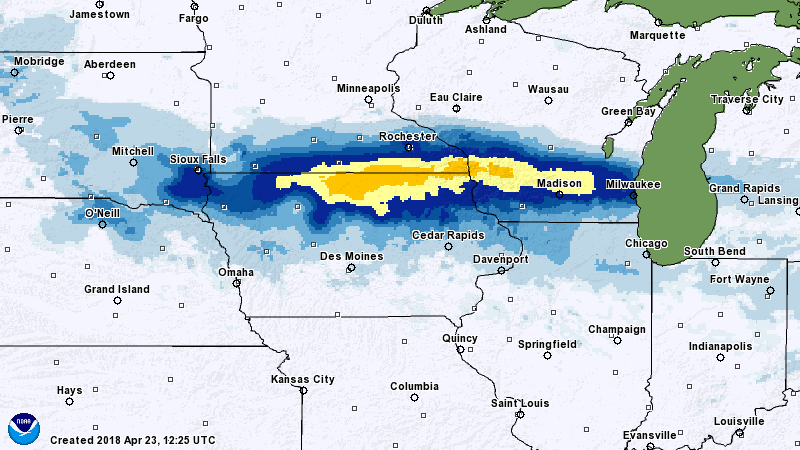
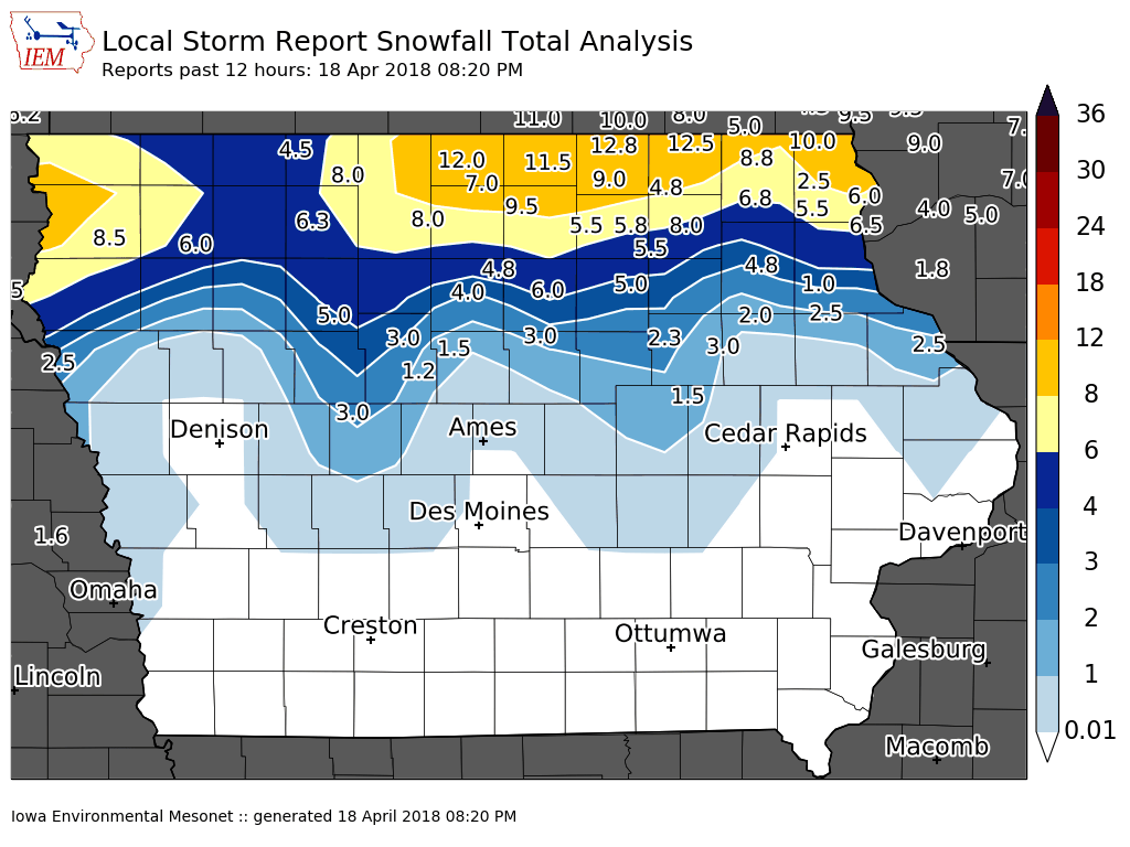
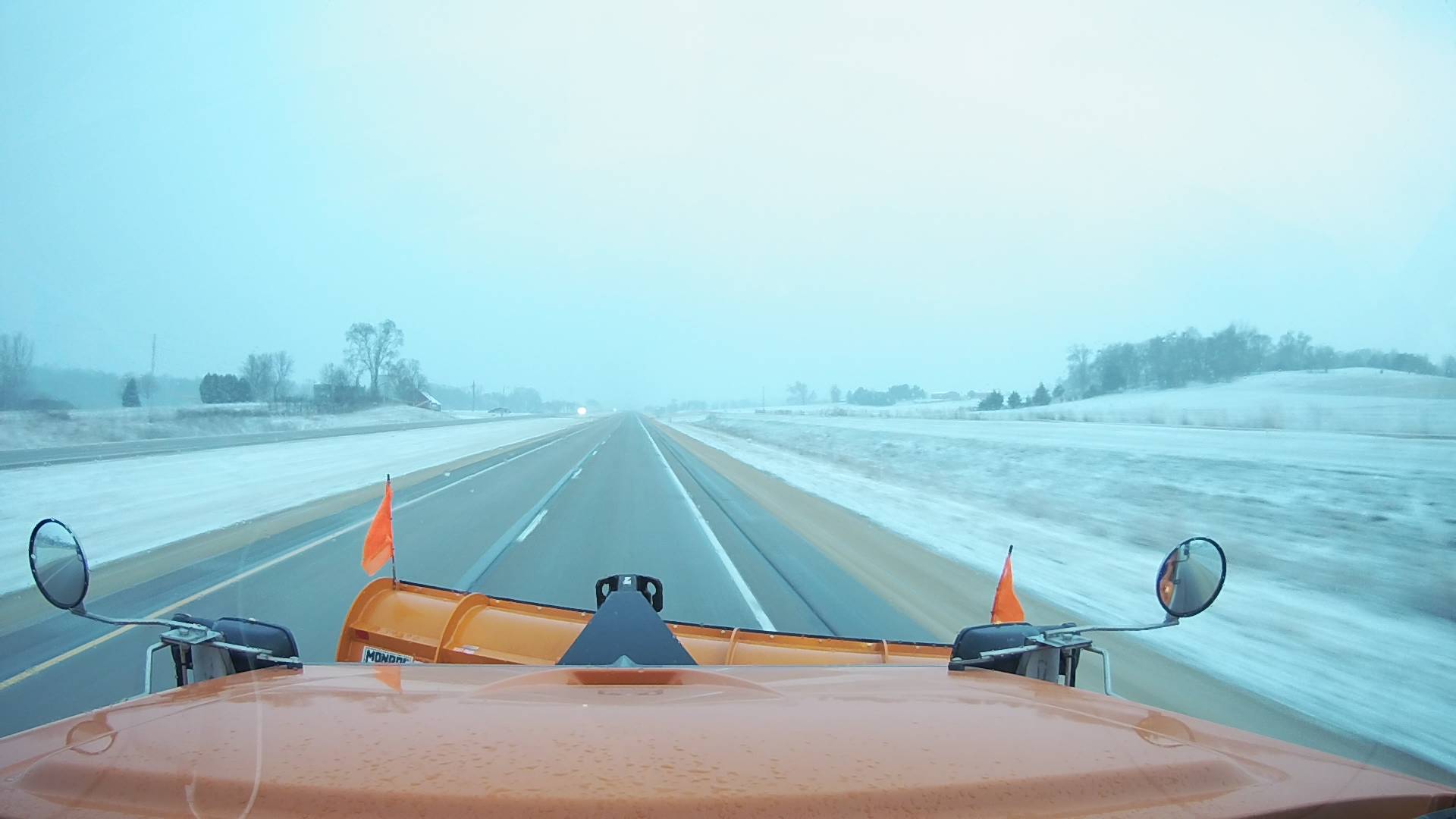
Scattered thunderstorms with rain, freezing rain, and sleet was seen across the area during the morning of Wednesday, April 18th; especially north and west of a line from Ottumwa to Dubuque. This resulted in slick roads and hazardous travel. Towards midday, the mixed precipitation had changed to snow north of Interstate 80. Snowfall accumulations of 1 to 3 inches were seen along and north of Highway 20. Higher amounts between 5 to 12 inches fell along the northern two tiers of counties in Iowa. Meanwhile, areas south of I-80 only saw rain from this storm system. Temperatures were only in the 30s to lower 40s; which is about 25-30 degrees below normal for late April. |
Weather Prediction Center Fronts/Pressure Loop  |
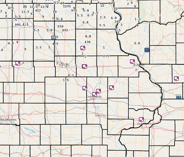
Snow/Ice/Hail
| Local Snowfall | Regional Snowfall | Iowa Snowfall (Totals through 4/18 820 pm) |
 |
 |
 |
Photos
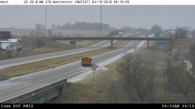
| Sleet near US 20 MM 277 @ Manchester, IA (IA DOT) |
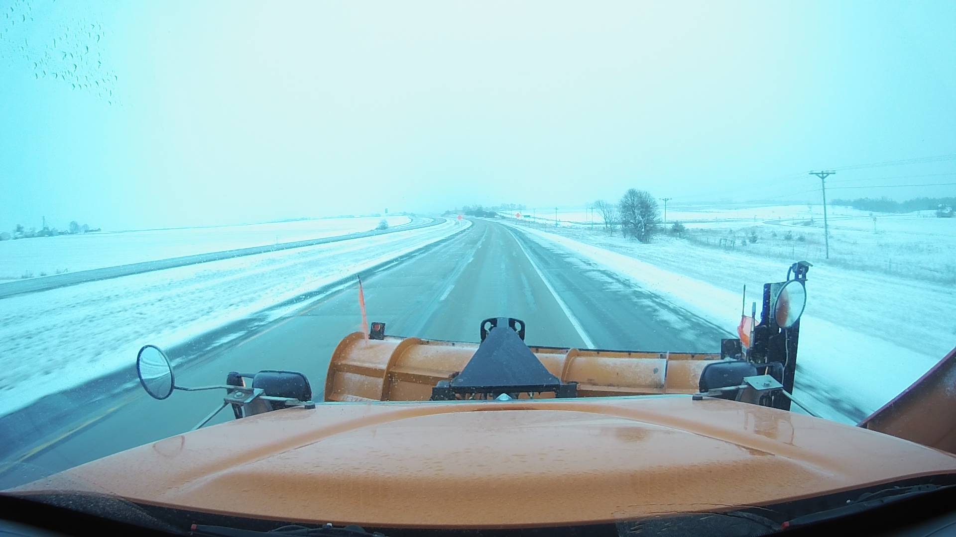
US 20 near Manchester 7:30 pm (IA DOT) |
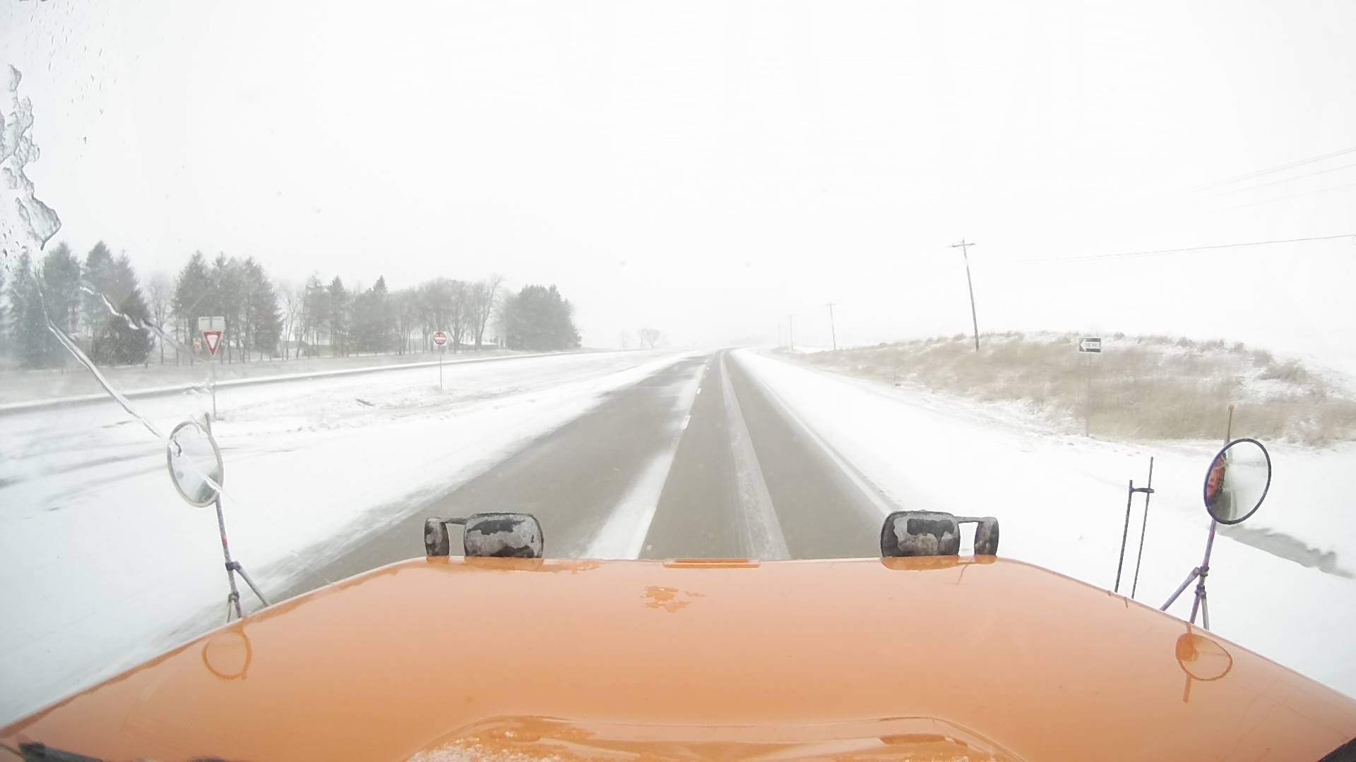
US 151 N (IA DOT) |
US 61 Central Jackson County (IA DOT) |
 |
 |
 |
 |
| Interactive Storm Report Map |
 |
PRELIMINARY LOCAL STORM REPORT...SUMMARY
NATIONAL WEATHER SERVICE QUAD CITIES IA IL
921 PM CDT WED APR 18 2018

..TIME...   ...EVENT...      ...CITY LOCATION...     ...LAT.LON...
..DATE...   ....MAG....      ..COUNTY LOCATION..ST.. ...SOURCE....
            ..REMARKS..

0818 PM     SNOW             4 WNW FOUNTAIN SPRINGS  42.64N 91.40W
04/18/2018  M2.5 INCH        DELAWARE           IA   TRAINED SPOTTER

            STORM TOTAL.

0802 PM     SNOW             1 NW CENTER GROVE       42.49N 90.73W
04/18/2018  E2.5 INCH        DUBUQUE            IA   TRAINED SPOTTER

            VERY WET SNOW.

0711 PM     SNOW             DUBUQUE REGIONAL ARPT   42.41N 90.73W
04/18/2018  M2.0 INCH        DUBUQUE            IA   OFFICIAL NWS OBS

            1.5" IN PAST 6 HRS. 0.5" SLEET THIS MORNING.

0708 PM     SNOW             JESUP                   42.48N 92.07W
04/18/2018  M3.0 INCH        BUCHANAN           IA   TRAINED SPOTTER


0642 PM     SNOW             5 N DYSART              42.24N 92.30W
04/18/2018  M1.5 INCH        BENTON             IA   PUBLIC

            SNOW ENDING.

0528 PM     SNOW             2 ENE HAZLETON          42.63N 91.86W
04/18/2018  M2.0 INCH        BUCHANAN           IA   CO-OP OBSERVER


1213 PM     FREEZING RAIN    MILLEDGEVILLE           41.97N 89.78W
04/18/2018  M0.10 INCH       CARROLL            IL   TRAINED SPOTTER

            ACCUMULATION WAS ON ELEVATED SURFACES.

1010 AM     HAIL             PEARL CITY              42.27N 89.83W
04/18/2018  E0.25 INCH       STEPHENSON         IL   EMERGENCY MNGR


1002 AM     HAIL             2 SW DAVENPORT MUNICIPA 41.59N 90.61W
04/18/2018  E0.25 INCH       SCOTT              IA   PUBLIC

            HAIL LASTED ABOUT TWO MINUTES IN RIDGEVIEW
            (NW DAVENPORT).

0911 AM     HAIL             1 NNE BUDD              42.55N 90.81W
04/18/2018  E0.25 INCH       DUBUQUE            IA   TRAINED SPOTTER

            PEA TO 1/8 AN INCH SIZE HAIL. BEGAN AT 9AM.
            STARTING TO ACCUMULATE ON THE GRASS.

0855 AM     HAIL             ANAMOSA                 42.12N 91.28W
04/18/2018  E0.25 INCH       JONES              IA   PUBLIC

            HAIL BEGAN AS PEA SIZED BUT IT NOW ABOUT AN
            1/8 OF AN INCH. HAIL IS COVERING THE GROUND.

0826 AM     HAIL             2 NNE CEDAR RAPIDS      42.01N 91.66W
04/18/2018  E0.25 INCH       LINN               IA   TRAINED SPOTTER

            JUST STARTED.

0750 AM     HAIL             2 ENE CEDAR RAPIDS      42.06N 91.57W
04/18/2018  E0.25 INCH       LINN               IA   PUBLIC


0737 AM     HAIL             1 E INDEPENDENCE        42.47N 91.88W
04/18/2018  E0.25 INCH       BUCHANAN           IA   PUBLIC

            PEA SIZED HAIL, SWITCHING TO ALL RAIN, AND
            NOW SLEET IN INDEPENDENCE. EAST SIDE OF
            INDEPENDENCE.

0731 AM     HAIL             1 NNW SHELLSBURG        42.11N 91.88W
04/18/2018  E0.25 INCH       BENTON             IA   TRAINED SPOTTER

            JUST BEGAN.

0718 AM     HAIL             INDEPENDENCE            42.47N 91.89W
04/18/2018  E0.25 INCH       BUCHANAN           IA   TRAINED SPOTTER
|
Rain Reports
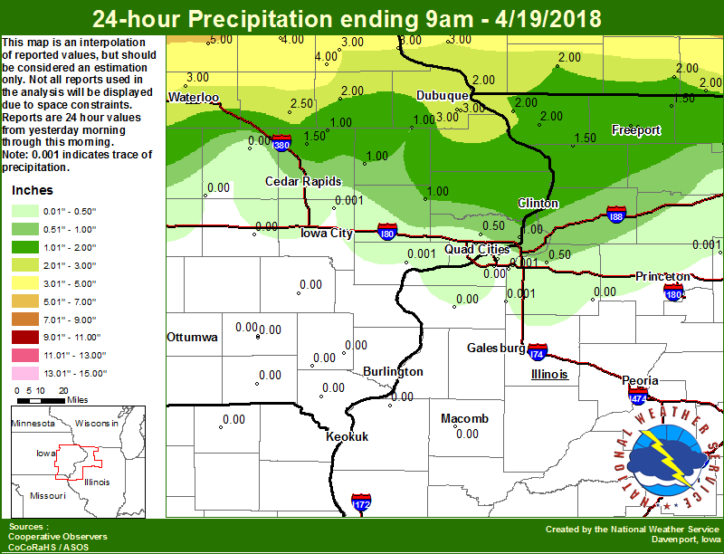 |
Environment
| Davenport, IA Sounding 7 AM 4/18/2018 |
Davenport, IA Sounding 7 PM 4/18/2018 |
Weather Prediction Center - Surface Low Tracks (with uncertainty circles) |
 |
 |
 |
 |
Media use of NWS Web News Stories is encouraged! Please acknowledge the NWS as the source of any news information accessed from this site. |
|