|
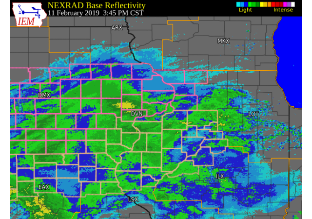
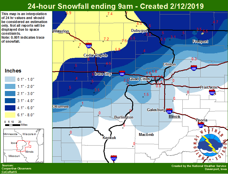
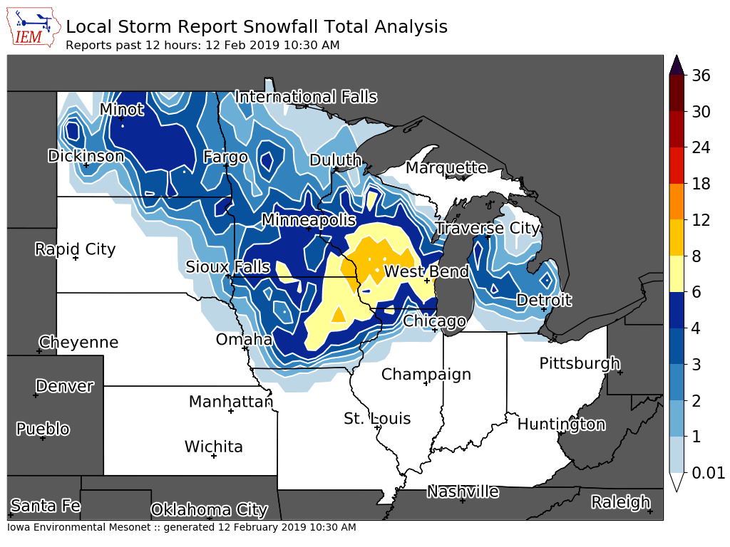
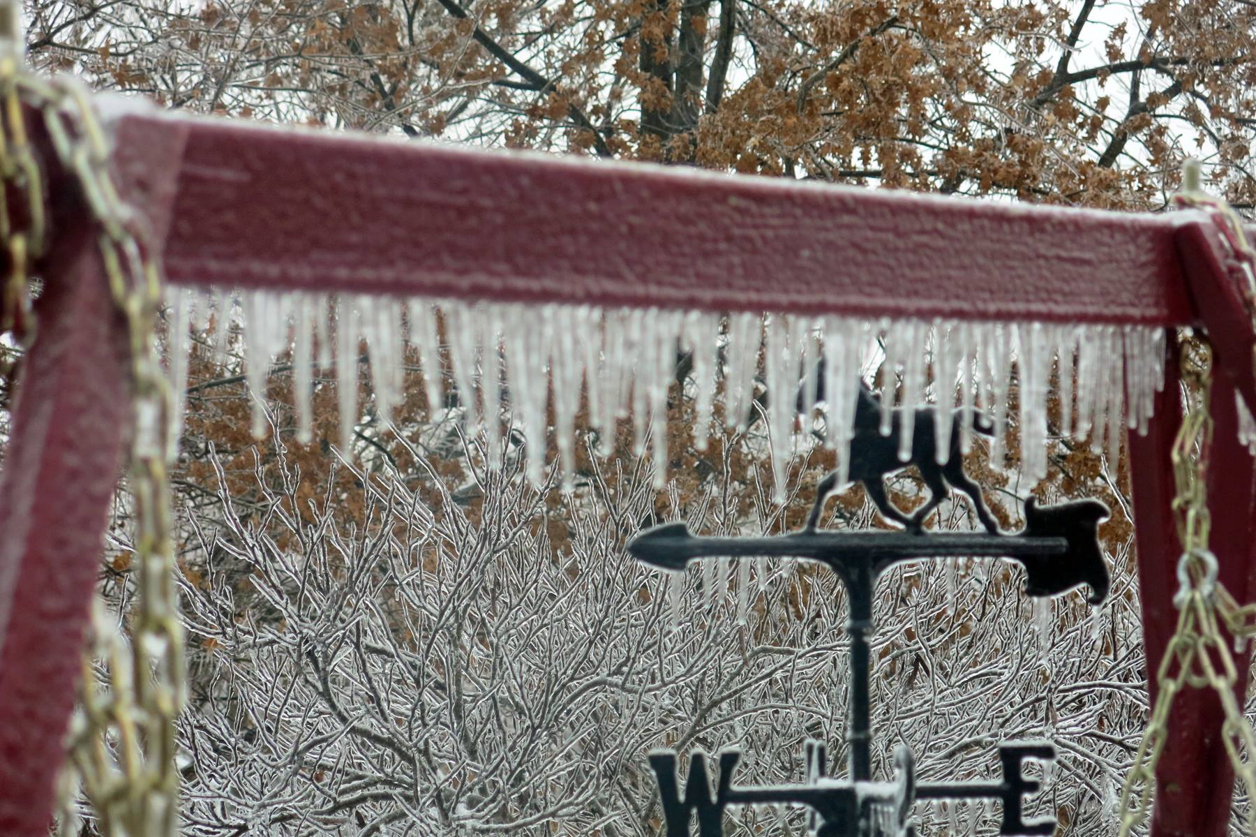
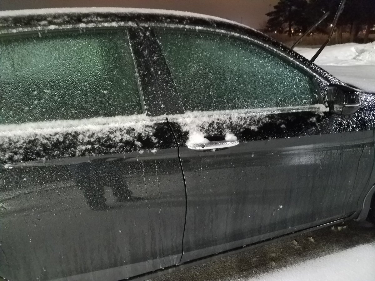
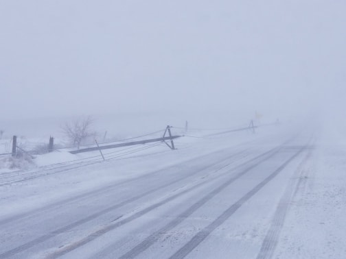
A winter storm moved from the southern Plains into the Great Lakes Monday, Feb. 11 into Tuesday, Feb. 12, bringing snow, freezing rain and some sleet to the area. Significant snow accumulations of 6 to 9 inches fell across portions of northeast Iowa and far northwest Illinois. Ice accumulations from freezing rain ranged from a light glaze to over a quarter inch; especially in parts of northwest Illinois. Strong winds between 40 and 50 mph were common across the region on the back side of this system. |
 |
|
|
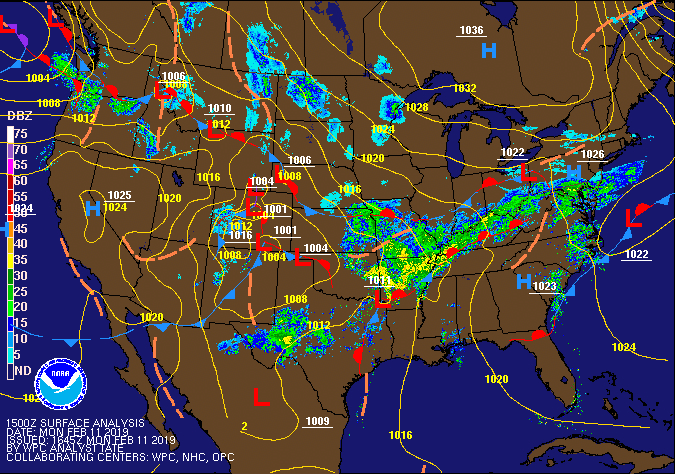
Pressure / Fronts / Radar Loop (Weather Prediction Center) |
Snow/Ice
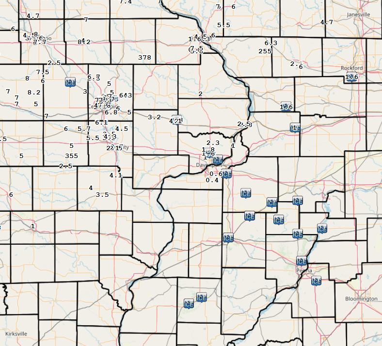
| LOCAL SNOW/ICE MAP | REGIONAL SNOW/ICE MAP | IOWA LSR ANALYSIS |
 |
 |
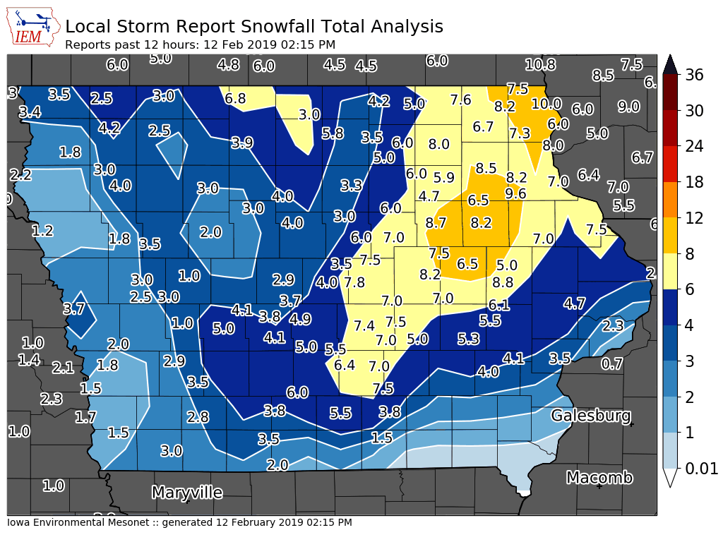 |
24 hour snow fall in inches,
for eastern Iowa, northwest
and west central Illinois,
and northeast Missouri.

Reported between Midnight and 9 AM,
Tuesday February 12, 2019.

....IOWA....
Cresco 1 NE                       7.6
Grinnell 2 SW                     7.5
Fayette 1 NW                      7.5
Monticello 1 E                    7.5
Elkader 6SSW                      7.4
Coggon                            7.2
Mount Auburn 2.2 NNW              7.0
Pella 4 N                         7.0
Vinton                            7.0
Toledo 3 N                        7.0
Guttenberg Dam 10                 7.0
Rickardsville 0.2 W               6.5
Dubuque LD11                      6.0
Marshalltown 1 NW                 6.0
Kalona 7.3 NNW                    6.0
Fairfax 4.0 NW                    6.0
Tripoli 0 N                       5.9
Anamosa 3 SSW                     5.8
Dubuque Arpt 7 SW                 5.8
Cascade                           5.5
Bellevue LD12                     5.1
Marengo 2.6 SSW                   5.0
Wellman 4.0 E                     5.0
Sigourney                         5.0
NWS Johnston* 5 NNW               4.6
Solon 0.3 ESE                     4.5
North English                     4.0
Mason City 1 NNE                  4.0
Maquoketa 4 W                     4.0
Beaconsfield 1 NNE                3.5
Washington                        3.5
Perry 0 W                         3.3
Hampton 1 N                       3.3
Ames US 30 2 SSE                  3.0
Boone 1 SSW                       2.9
Muscatine 2N                      2.5
Eldridge 0.7 SSW                  1.8
Davenport Arpt 5 N                1.6
Bettendorf 2.2 SE                 1.5
Rathbun Reservoir 2 N             1.5
Riverdale 0.5 N                   1.5
Davenport 0.9 SSW                 1.2
Muscatine 2.1 N                   1.0
Davenport 0.9 WNW                 1.0
Fairfield                         1.0
Salem 1S                          0.0
....ILLINOIS....
Dakota 4.8 NW                     6.5
Freeport 1.2 E                    6.0
Galena                            5.0
Stockton 3.4 NNE                  5.0
Freeport 2.0 NW                   4.5
Freeport 1.7 ESE                  4.0
Winslow 4.3 ESE                   3.5
Freeport                          3.2
Elizabeth                         3.1
Freeport 1.7 NW                   3.0
Rockford ASOS                     2.2
Roscoe 2SE                        1.8
Mundelein                         1.6
Aledo                             1.5
Moline 0.9 N                      1.2
Rochelle                          1.2
Moline 0.7 NNE                    1.1
Quad City Arpt 3 S                0.6
Coleta 1.4 SSW                    0.3
Romeoville                        0.0
Princeton                         0.0
Geneseo 2.0 NW                    0.0
Windsor                           0.0
Augusta                           0.0
Gladstone LD18                    0.0
Steward                           0.0
Streator 3 SE                     0.0
Kewanee 1 E                       0.0
Colchester 3.5 NE                 0.0
Ogden                             0.0
Dallas City 3.0 SSE               0.0
Macomb                            0.0
Tuscola                           0.0
Altona                            0.0
....MISSOURI....
Memphis                           0.0
Columbia                          0.0
....WISCONSIN....
La Crosse WFO                     7.7
Viroqua                           6.8
Madison-ASOS                      5.7
Steuben 4SE 3 NE                  4.8
Brodhead 1 SW                     4.7
Beloit-College                    3.0
|
Photos
 |
 |
 |
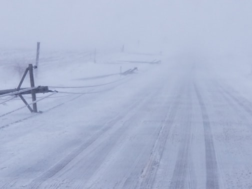 |
| Mt Pleasant, IA (Photo: Jean Leeper) |
NWS Office Davenport, iA (Photo: Tim Gross) |
12 poles down in a row along Osco Road between US 6 and IL 81. Courtesy of Henry County Office of Emergency Management |
Courtesy of Henry County Office of Emergency Management |
Storm Reports Map - Courtesy IEM
 |
| Storm Report Map (Courtesy IEM) |
|
PRELIMINARY LOCAL STORM REPORT...SUMMARY
INCHES LOCATION ST COUNTY TIME 6.3 SPRINGVILLE IA LINN 0730 AM
INCHES LOCATION ST COUNTY TIME |
Rain Reports
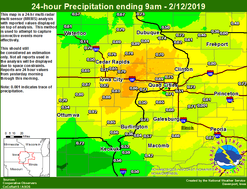 |
| LOCAL RAINFALL MAP |
24 hour precipitation reports (in Inches),
for eastern Iowa, northwest and west central Illinois,
and northeast Missouri. Reported between Midnight and 9 AM,
Tuesday February 12, 2019.

....IOWA....
Fairfield                        0.92
Monticello 1 E                   0.89
Washington                       0.88
North English                    0.87
Muscatine 2.1 N                  0.86
Salem 1S                         0.85
Muscatine 2N                     0.85
Cascade                          0.84
Ainsworth 7.4 N                  0.83
Kalona 7.3 NNW                   0.82
Grinnell 2 SW                    0.82
Davenport 0.9 WNW                0.80
Sigourney                        0.80
Manchester 1.1 N                 0.79
Iowa City 8.0 NE                 0.79
Anamosa 3 SSW                    0.78
Riverdale 0.5 N                  0.76
Marion 1.7 NNW                   0.76
Le Claire LD14                   0.75
Eldridge 0.7 SSW                 0.75
Dubuque Arpt 7 SW                0.74
Bettendorf 2.2 SE                0.74
Guttenberg Dam 10                0.73
Vinton                           0.70
Maquoketa 4 W                    0.70
Davenport Arpt 5 N               0.69
Coggon                           0.69
Elkader 6SSW                     0.67
Donnellson                       0.66
Marengo 2.6 SSW                  0.65
Davenport 0.9 SSW                0.65
Solon 0.3 ESE                    0.65
Centerville 0 NE                 0.63
Iowa City Arpt                   0.63
Bellevue LD12                    0.62
Pella 4 N                        0.62
Waterloo ASOS 5 NW               0.61
Cresco 1 NE                      0.58
Tripoli 0 N                      0.57
Ottumwa ASOS 6 NNW               0.54
Keokuk LD19                      0.52
Rathbun Reservoir 2 N            0.51
Marshalltown 1 NW                0.51
Dubuque LD11                     0.50
Fairfax 4.0 NW                   0.50
Fayette 1 NW                     0.45
Toledo 3 N                       0.43
Cedar Rapids Arpt 5 SW           0.37
Burlington 6.5 SSW               0.36
Beaconsfield 1 NNE               0.32
Oskaloosa AWOS 9 ESE             0.29
NWS Johnston* 5 NNW              0.29
Mason City 1 NNE                 0.28
Perry 0 W                        0.26
Boone 1 SSW                      0.24
Ames US 30 2 SSE                 0.21
Hampton 1 N                      0.21
Mason City ASOS 6 W              0.12
Mount Auburn 2.2 NNW             0.11
Pella AWOS 2 WSW                 0.09
Grinnell AWOS 2 SSW              0.08
....ILLINOIS....
Streator 3 SE                    0.90
Coleta 1.4 SSW                   0.80
Bloomington Airport              0.78
Moline 0.9 N                     0.77
Ottawa 4 SW                      0.75
Freeport 1.7 NW                  0.74
Lincoln NWS                      0.74
Geneseo 2.0 NW                   0.73
Gladstone LD18                   0.73
Mendota 2 SE                     0.72
Galena                           0.72
Moline 0.7 NNE                   0.72
Quad City Arpt 3 S               0.71
Ill. City LD16 3 WNW             0.71
Altona                           0.71
Freeport 2.0 NW                  0.70
Galesburg                        0.70
Macomb                           0.68
Alexis 1 SW                      0.68
Peoria ASOS                      0.67
Prairie City 2S                  0.66
Aledo                            0.65
Mundelein                        0.65
Dallas City 3.0 SSE              0.64
Rochelle                         0.64
Freeport                         0.63
Romeoville                       0.61
Kewanee 1 E                      0.61
Elizabeth                        0.61
Dakota 4.8 NW                    0.60
Rockford ASOS                    0.59
Warsaw 5.8 SE                    0.59
Ogden                            0.58
La Harpe                         0.57
Freeport 1.7 ESE                 0.56
Colchester 3.5 NE                0.56
Steward                          0.53
Coal Valley 2.6 E                0.51
Roscoe 2SE                       0.51
New Boston LD17                  0.50
Quincy ASOS                      0.50
St Anne                          0.50
Decatur Airport                  0.47
Stockton 3.4 NNE                 0.46
Tuscola                          0.45
Windsor                          0.44
Jacksonville AWOS                0.43
Augusta                          0.42
Winslow 4.3 ESE                  0.36
Joliet                           0.26
Galva 2.7 NE                     0.00
....MISSOURI....
Memphis                          0.72
Chillicothe 2 NW                 0.69
Canton LD20                      0.56
Kirksville ASOS                  0.55
Columbia                         0.13
....WISCONSIN....
Viroqua                          0.68
Steuben 4SE 3 NE                 0.51
Brodhead 1 SW                    0.48
Beloit-College                   0.45
Madison-ASOS                     0.40
Watertown-AWOS                   0.00
Prairie du Chien AWOS            0.00
|
Environment
| DAVENPORT SOUNDING 2/11/2019 6 AM |
DAVENPORT SOUNDING 2/11/2019 6 PM |
 |
 |
 |
Media use of NWS Web News Stories is encouraged! Please acknowledge the NWS as the source of any news information accessed from this site. |
|