
Tropical Depression Two is expected to gradually strengthen and could bring tropical storm conditions to the Florida Panhandle beginning late Monday. Areas of flash flooding will be possible through Thursday along the eastern and central Gulf Coast. Severe thunderstorms will develop and move along a cold front crossing the Upper Midwest Monday, and through the Ohio Valley/Mid-Atlantic on Tuesday. Read More >
Corpus Christi, TX
Weather Forecast Office
The National Climatic Data Center (NCDC) calculates new climatological normals every 10 years based upon the previous 30-year period. Climatological normals of temperature and precipitation are two of the most common types of normals but many other normals (such as winds, snowfall and heating degree days) are calculated. Prior to July 1, 2011, the 30-year period used in the calculation of climatological normals was from 1971 to 2000. From now through the next decade, the new 30-year period used to calculate climatological normals will be from 1981 through 2010. Officially, these new normals began being used as of August 1, 2011 in our daily climate products:
The new normals (1981-2010) will be incorporated into the 2011 August monthly climate information (which will be produced on September 1, 2011). Our monthly climate products are:
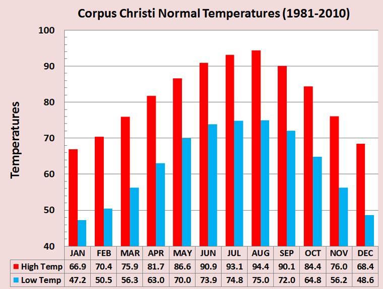
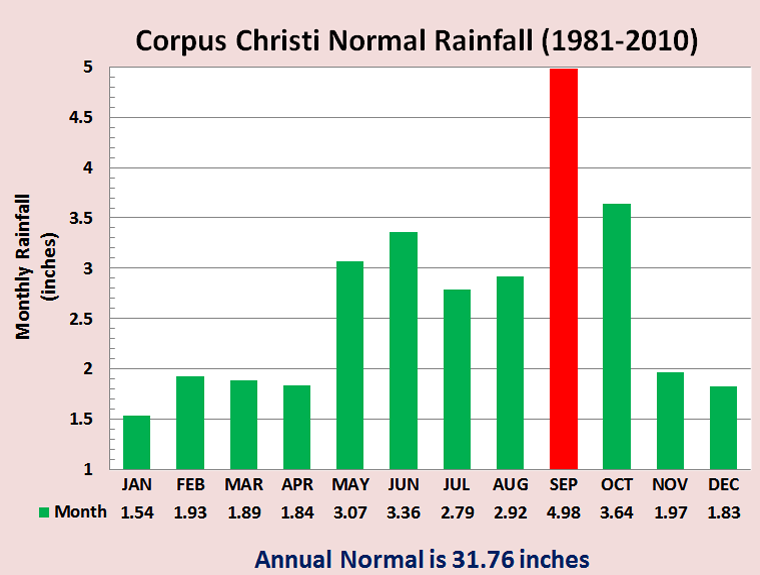
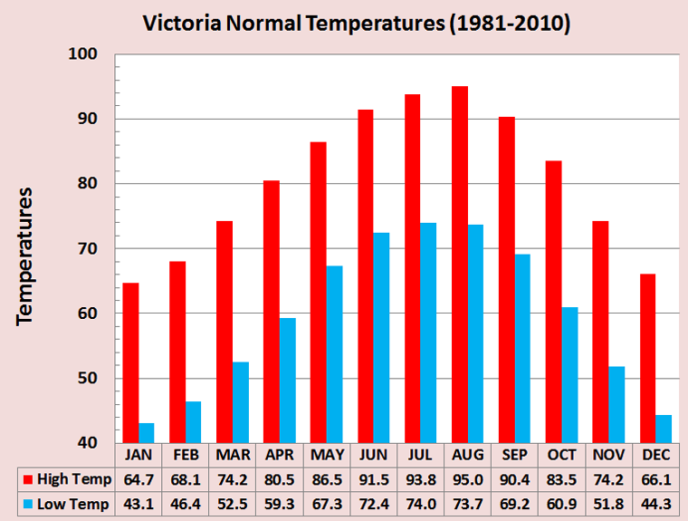
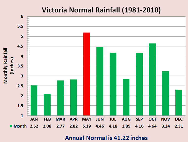
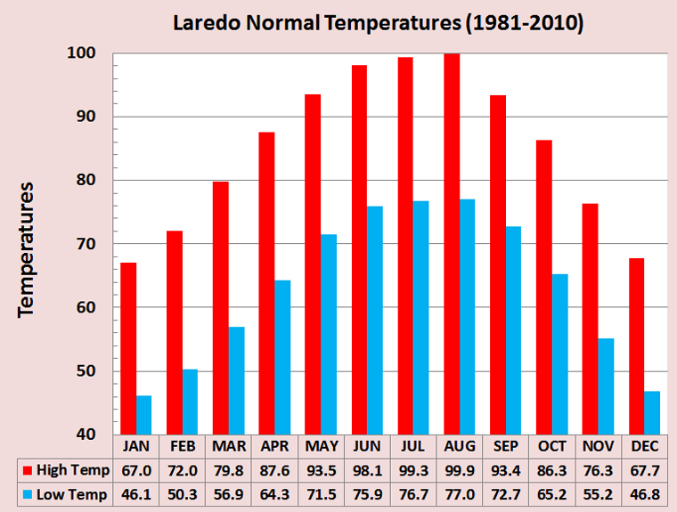
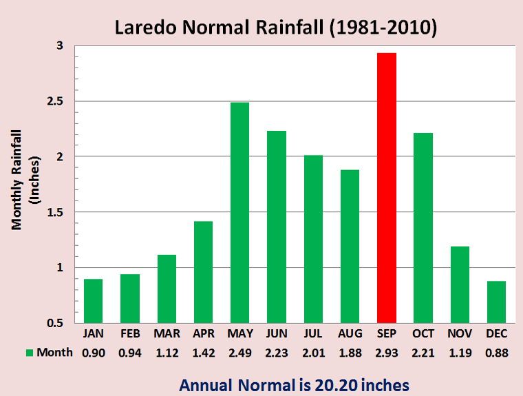
For more information on the new climatological normals, please go to the NCDC web page. Monthly data exists below (click images for higher resolution) for Corpus Christi, Victoria and Laredo.
CURRENT HAZARDS
National Hazards Graphical
Local Storm Reports
Submit a Storm Report
Daily Video Briefing
CURRENT CONDITIONS
Detailed Observations Map
Hourly Weather Roundup
Local Satellite Page
Rivers and Lakes
GOES-East Satellite
MADIS Display
5-minute Observations
FORECASTS
Activity Planner
Aviation
Fire
Marine
Tides
National Outlooks
Extended Outlooks
NWPS
Graphical
TROPICAL
Local Tropical Page
Storm Surge Maps
English Hurricane Guide
Spanish Hurricane Guide
Past Tropical Cyclones
Storm Surge Threat
EDUCATION
Basic Weather Education
Online Weather School
Product Guide
US Dept of Commerce
National Oceanic and Atmospheric Administration
National Weather Service
Corpus Christi, TX
426 Pinson Dr
Corpus Christi, TX 78406
(361) 289-0959
Comments? Questions? Please Contact Us.

