|
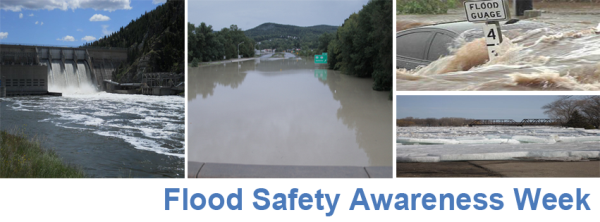
Flooding
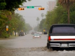
Floods occur nationwide, and are the deadliest weather related killer in the United States. Flooding can be caused by a variety of weather hazards, including tropical cyclones, low pressure systems, thunderstorms, snowmelt, and debris flows. Rivers can rise out of their banks, heavy rains can flood poor drainage urban roads, and torrential rains can raise water into structures. In essence, all flooding can be life-threatening, so people need to stay informed of developing flood situations, and be prepared to take quick action to avoid danger.
Flood Terms
Since the 1970s, inland flooding has been responsible for more than half of the deaths associated with tropical cyclones in the United States. The following are some terms the NWS uses to inform communities of flood threats:
- A Flood Watch or Flash Flood Watch is issued when conditions are favorable for flooding to occur.
- A Flash Flood Warning is issued when flooding is occurring or imminent, threatening life or property. Generally, a flash flood is defined as:
* ≥3 feet of standing water (less if threatening life or property); and/or
* ≥6 inches of fast flowing water across road or bridge, or
* Water in a stream or arroyo flowing rapidly out of its banks, or
* A dam break.
- A Flood Warning, also known as an "Areal Flood Warning" is issued when high water, threatening life or property, continues well after rains have ended. Often, Flood Warnings will cover large areas. Definitions used for threats to life and property are the same as for a Flash Flood Warning.
- An Urban Flood Advisory is issued for nuisance flooding in populated areas. Generally, urban flooding is defined by standing water less than 3 feet deep that is not a direct threat to life or property, often occuring in poor drainage areas. This is the most common flood type in the Rio Grande Valley.
- A River Flood Warning is issued when flood stages are exceeded along main stem rivers, creeks, or streams. River flooding is defined as minor, moderate, and major. Moderate and Major flooding caused the most destruction.
|
|
Drought
When there is a deficiency of precipitation over an extended period of time, resulting in a water shortage for an activity, group, or environmental sector, a drought is underway. The impacts of drought are greater than the impacts of any other natural hazard. Drought costs the United States about 6 to 8 billion dollars annually, and the costs affect agriculture, transportation, and recreation, tourism, forestry, and energy. The impacts of drought can be reduced through mitigation and preparedness.
From Flood to Drought...and Back...and Forth...and??
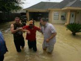
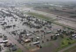
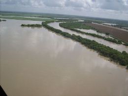
The short distance contrast between semi arid west central and south central Texas and the semi to subtropical Gulf of America results in sharp swings in weather regimes for locations in between, including the Rio Grande Valley. Above average rainfall and numerous flood episodes through the middle of 2007 were quickly replaced by moderate to extreme drought conditions by spring of 2008, punctuated by a 25,000 acre wild fire in late March. In early July 2008, tropical moisture associated with a series of easterly waves put a significant dent in the drought. Hurricane Dolly, which made landfall on July 23rd 2008, produced widespread torrential rains of 6 to 12 inches, with isolated totals of 18 inches, effectively ending the drought conditions in Deep South Texas in 2008. These torrential rains produced widespread flooding across Cameron, Willacy, and Hidalgo County, where hundreds of roads and streets were under high water, in some places 3 feet or more. Several flooded structures in Laguna Vista and in nearby areas required water rescues. Most of the resacas filled to bank full, and in some areas the water spilled over their banks, exacerbating the flood situation. Many arroyos, mainly in Starr and Zapata County filled quickly with the heavy rainfall.
Occasional bouts of summer thunderstorms through September 2008 induced additional local flooding, most prominent in southwest Starr County between August 18th and 24th. The arrival of mid autumn brought drier weather, a common occurrence after strong fronts whisk away the last of deep tropical moisture.
In the spring and summer of 2009, Deep South Texas experienced extreme to exceptional drought conditions, with devastating impact to the region’s dryland crop yield. Virtually all the cotton crop, most of the corn crop, and cattle grazing land was burned up in record summer heat, little rainfall, frequently gusty winds, and low humidity for most of June through August. More than $20 million in crop losses were reported in Cameron County alone. Welcome rains returned in September, alleviating the drought. By December, a strengthening El Niño brought additional rains, ending the drought. By the end of February 2010, the Lower Rio Grande Valley had a surplus of winter rain.
A relatively moist spring set the stage for potential summer flooding, which occurred in some areas with the rain bands from Alex, and ended with a September soaking. The Rio Grande Flood through July and August was most memorable, but related to flow of water into the basin from incredible post Alex rain in the Sierra Madre. The rain spigot shut off in October, and would remain off through December. By the end of the year, green ranchlands were brown, and wildfire became a primary threat. Three month rainfall from October to December fell to record lows; by early January 2011, drought had built to severe levels west of Highway 281.
The 2011 Water Year (October 2010 to September 2011) Drought began taking a toll by late spring, when dryland crops withered by mid June. A massive ranch wildfire brought the initial drought to a head before some welcome rainfall to close June. Dry, hot, and breezy conditions resumed in July, and continued through the normally wettest month of September, which saw blazing heat and virtually no rainfall. Exceptional drought conditions returned to much of the Valley through January 2012 before a welcome reprieve of cool, damp, rainy weather for a good part of February.
The latest drought began in early 2011 and finally ended, at least temporarily, in March 2014. Local floods occurred during this prolonged drought. The recent three–year Rio Grande Valley drought was locally dented by flooding rains in 2012 and 2013. The City of McAllen was pummeled by 4 to 6 inches of rain and dangerous urban/flash flooding during the March 29th, 2012 hailstorm. Nearly six inches of rain inundated portions of Brownsville and created dangerous urban/flash flooding on June 30th, 2012. A band of tropical rains overtopped arroyos near Rio Grande City on September 20, 2013, and more than four inches of rain in under two hours flooded neighborhoods in West Brownsville on November 6, 2013.
|

