 |
||||||||
|
||||||||
| Flood Safety Awareness for the RGV |
||||||||
|
The Advanced Hydrologic Prediction System (AHPS) provides water prediction and delivery methods to serve your needs and the needs of all our partners in protecting life and property ranging from floods to droughts. AHPS provides you with user friendly text and graphical forecasts that are available online. The goal of these products is to help emergency managers to be better prepared to defend their communities from floods, and helps recreational water users stay out of harms way. AHPS enables you to get reliable answers to such questions as:
|
||||||||
|
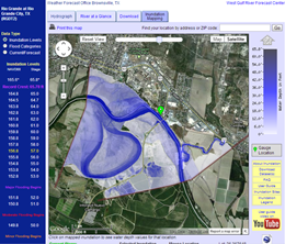
Inundation Mapping Click on the map to view and experiment with the Rio Grande City inundation map. For starters, mouse over the flood crest values on the left hand side and watch the inundation area expand and contract. Follow the instructions to determine water depth at any location in the shaded area. The map indicates the scope of inundation from the Falcon Dam releases following Hurricane Alex in 2010 (flood stage of 57 feet above North American Vertical Datum 1988). |
 Inundation map for Rio Grande City river gage |
|||||||
|
The National Weather Service added even more enhancements to the AHPS pages in spring 2012. Known as "Phase VII Enhancements", they included:
Graphic examples of the enhancements can be found here.
|
||||||||
|
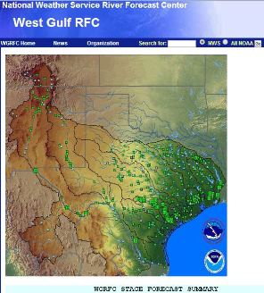
National and Regional NWS Hydrology Information West Gulf River Forecast Center (WGRFC), based in Fort Worth, has an expert staff dedicated to forecasting the impacts of heavy rain on water flows along rivers, creeks, and streams that flow into the Gulf of America. These include the Lower Colorado River near Austin, the Trinity River near Dallas, and the Rio Grande (right). Hydrologists at WGRFC evaluate rain forecasts, rainfall observations, and water flows to create river forecasts and river flood warning guidance when the potential for rivers, creeks, streams, and lakes could flood nearby and downstream communities. WGRFC hydrologists and meteorologists collaborate with a variety of governmental partners across two borders, including the United States Geological Survey, the International Boundary and Water Commission, the Texas Commission on Environmental Quality, and many more. WGRFC is a critical part of NWS Brownsville/Rio Grande Valley flood warning operations for the Rio Grande and the Lower Rio Grande Flood Control Project (Floodway). |
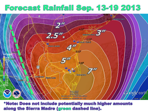
 Quantitative Precipitation Forecast (QPF) issued by the Weather Prediction Center for a wet period across Deep South Texas in September 2013  West Gulf River Forecast Center coverage area (shaded). Forecast points and values were shown from March 13, 2014 |
|||||||
| Return to Index | ||||||||