|
The 1977 PDO Regime Shift |
|
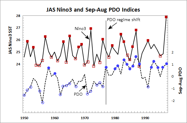
Dramatic fluctuations in climate can be referred to as regime shifts. The 1977 regime shift in the northern Pacific has been documented in numerous research publications, and is illustrated in the graphic below. The shift was evident in the temperature structure of the northern Pacific Ocean from a relatively cool to a warm state. The figure below, the variation in the Niño-3 Sea Surface Temperatures for July through September for the period 1950 through 1998 are shown by the solid line. Large positive values correspond to El Niño events while negative values are associated with La Niña events. The highest and lowest tercile values are depicted by solid and open squares. The dashed line depicts annual average values of the Pacific Decadal Oscillation, or PDO, with solid and open circles depicting the upper and lower terciles. The regime shift is marked by a trend towards more positive values leading to warmer equatorial waters and a cooler Northern Pacific. Fifteen of sixteen lower-tercile PDO values occur before 1977, while 14 of 15 upper-tercile values occur after 1976. Other research has shown that variation in the north Pacific have a modulating effect on ENSO variations such that anomalies in Northern Hemisphere winter are enhanced during periods of El Niño and high PDO or La Niña and low PDO. Thus, in our precipitation charts, particularly those for southern locations where the ENSO signal is stronger, positive precipitation anomalies during El Niño events tend to be greater after the 1977 regime shift. |
 |
| Fig. 1a from Gutzler et al (2002). Annual values of JAS Niño-3 SST values (solid line, C) and the Sep-Aug PDO index (dashed line) for 1950-1997; years of PDO index correspond to the summer months (e.g. Sep 1950 - Aug 1951 average is plotted as 1951). The solid and open squares (red) mark annual values in the upper and lower terciles of the 48-year sample of Niño-3. The solid and open circles (blue) mark the upper- and lower-tercile PDO values. |
|
References: Gershunov, A. and T. P. Barnett, 1998: Interdecadal modulation of ENSO Teleconnections. Bulletin of the American Meteorological Society, 79, 2715-2725. Gutzler, D. S., D. M. Kann and C. Thornbrugh, 2002: Modulation of ENSO-Based Long-Lead Outlooks of Southwestern U.S. Winter Precipitation by the Pacific Decadal Oscillation. Weather and Forecasting, 17, 1163-1172. Hare, S. R., and N. J. Mantua. 2000. Empirical Evidence for North Pacific Regime Shifts in 1977 and 1989. Progress in Oceanography, 47, no. 2-4: 103-45. Stephens, C., S. Levitus, J. Antonov, and T.P. Boyer, 2001: On the Pacific Ocean Regime Shift. Geophysical Research Letters, 28, 3721-3724. |