Marquette, MI
Weather Forecast Office
If the page does not refresh automatically, you may need to refresh your browser to see the latest data.
All times are in Eastern Standard Time (EST).
| Current Observation | ||||
| 6/01/26 11:05am EST | ||||
| Temperature: | 65.6°F | Wind Direction: | E |  |
| Wind Chill: | 65.6°F | Wind Speed: | 4 mph | |
| Dew Point: | 37.2°F | Wind Gust: | 6 mph | |
| Relative Humidity: | 35% | |||
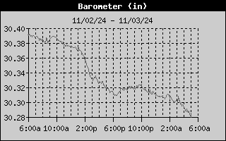
| Barometric Pressure: | 30.12 inches | |||
| Rainfall: | 15min: 0.00" | 1hr: 0.00" | 3hr: 0.00" | 24hr: 0.00" |
| Today (since Midnight EST) | ||||
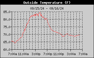
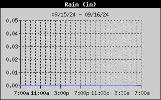
| Maximum Temperature: | 65.7°F at 11:05am | Rainfall: | 0.00 inches | |
| Minimum Temperature: | 39.5°F at 5:50am | Max Instant Rain Rate: | 0.00 in/hr at 12:00am | |
| Maximum Wind Chill: | 65.6°F at 11:05am | Maximum Wind Gust: | 12 mph at 10:00am | |
| Minimum Wind Chill: | 39.5°F at 6:05am | Max Wind Gust Direction: | ENE | |
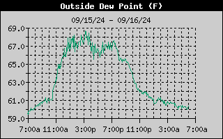
| Maximum Dew Point: | 44.6°F at 8:30am | Max Barometric Pressure: | 30.12 inches | |
| Minimum Dew Point: | 35.1°F at 9:15am | Min Barometric Pressure: | 30.04 inches | |
| Maximum Relative Humidity: | 86% at 5:50am | |||
| Minimum Relative Humidity: | 35% at 9:15am | |||
| Last 24 Hours | |
  |
|
  |
|
  |
|
  |
|
| Monthly Total | Yearly Total |
| Note: Does not include liquid-equivalent from frozen precipitation. | |
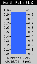 |
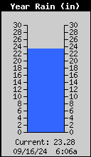 |
US Dept of Commerce
National Oceanic and Atmospheric Administration
National Weather Service
Marquette, MI
112 Airpark Drive South
Negaunee, MI 49866
906-475-5212
Comments? Questions? Please Contact Us.

