Winter Storm of January 22-23, 2018
|
A classic "Colorado Low" snowstorm impacted the Upper Mississippi River Valley and upper Great Lakes from Monday, January 22nd through Tuesday, January 23rd. The snow was exceptionally heavy and wet, with snow to water ratios averaging 7:1. The snow also mixed with freezing drizzle at times across the southeast half of Upper Michigan as well as the Keweenaw Peninsula. Due to the very dense nature of the snow, conditions were very slippery and travel was hazardous through the 22nd into the 23rd.
Here's a look at storm summaries from neighboring offices (opens new tabs):
National Weather Service Weather Prediction Center
|
|
Snow Reports
Here's a list of snowfall reports:
...Snowfall Reports...

Location                     Amount    Time/Date

...Michigan...

...Alger County...
Chatham Experiment Farm      5.5 in    0900 AM 01/23
Munising                     4.5 in    0630 AM 01/23
Wetmore 15S                  4.2 in    0800 AM 01/23
Grand Marais 10S             4.0 in    0700 AM 01/23
Christmas                    4.0 in    1100 PM 01/22

...Baraga County...
4 E Pequaming                10.8 in   1148 AM 01/23
Herman                       8.0 in    0800 AM 01/23
Three Lakes                  7.5 in    0800 AM 01/23
1 NNW Keweenaw Bay           6.0 in    0500 AM 01/23
Michigamme 3WNW              4.9 in    0800 AM 01/23

...Delta County...
9 S Rapid River              6.0 in    1130 AM 01/23
Gladstone 2NW                5.7 in    0700 AM 01/23
Bark River                   5.0 in    0800 AM 01/23
Escanaba                     5.0 in    0700 AM 01/23
Gladstone                    5.0 in    0745 AM 01/23
Garden Corners               3.6 in    0800 AM 01/23

...Dickinson County...
Iron Moutain 5N              4.5 in    0800 AM 01/23
Felch                        4.0 in    1245 AM 01/23
Norway                       3.1 in    0800 AM 01/23

...Gogebic County...
Watersmeet 12WSW             10.0 in   0700 AM 01/23
Ironwood WWTP                4.0 in    0800 AM 01/23

...Houghton County...
Kenton                       8.0 in    1000 PM 01/22
5NW Atlantic Mine            5.0 in    0900 AM 01/23
Painesdale                   4.8 in    0800 AM 01/23
Jacobsville                  3.9 in    0700 AM 01/23
1 E Houghton                 3.5 in    1000 AM 01/23
Chassell                     3.0 in    0811 PM 01/22
1 ENE Hancock                2.0 in    1216 PM 01/23

...Iron County...
2 SSE Stambaugh              5.5 in    0800 AM 01/23
Amasa 1W                     5.2 in    0900 AM 01/23
Iron River                   4.0 in    0929 PM 01/22
2 E Peavy Falls Dam          4.0 in    0840 PM 01/22

...Luce County...
2 SSE Soo Junction           6.0 in    0650 PM 01/22
Newberry City                4.9 in    0700 AM 01/23

...Marquette County...
4 N Negaunee                 11.5 in   0801 AM 01/23
Big Bay 1NW                  10.6 in   0800 AM 01/23
NWS Marquette                9.9 in    0742 AM 01/23
5 SSE Big Bay                9.8 in    0919 AM 01/23
2 NW National Mine           9.5 in    0700 AM 01/23
5 NNW Ishpeming              9.5 in    0600 AM 01/23
Harvey                       9.4 in    0800 AM 01/23
1 WNW Trowbridge Park        9.0 in    0245 AM 01/23
4 NNW Sands                  8.0 in    1033 AM 01/23
2 N Arnold                   6.0 in    0800 AM 01/23
Clarksburg                   6.0 in    0700 AM 01/23
Marquette 6.5 SSE            5.5 in    0600 AM 01/23
Green Garden                 4.7 in    0841 AM 01/23

...Menominee County...
3 SSW Cedar River            6.0 in    0922 AM 01/23
4 WNW Menominee              4.0 in    0900 AM 01/23
Cedar River                  4.0 in    0821 PM 01/22
Menominee                    2.8 in    0900 AM 01/23

...Ontonagon County...
Paulding                     10.3 in   0730 AM 01/23
2 N Paulding                 8.8 in    1030 PM 01/22
Ontonagon                    2.0 in    0800 AM 01/23

...Schoolcraft County...
Manistique WWTP              6.0 in    0700 AM 01/23
7 ENE Garden                 5.0 in    0749 AM 01/23
Cooks 2NE                    4.4 in    0800 AM 01/23
Parent Bay                   4.0 in    1056 AM 01/23

Observations are collected from a variety of sources with varying
equipment and exposures. We thank all volunteer weather observers
for their dedication. Not all data listed are considered official.

$$
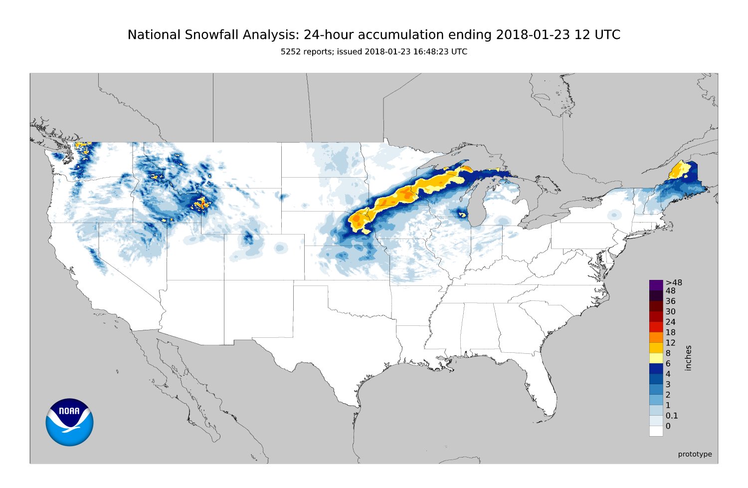
Here's a look at regional snowfall totals provided by the Weather Prediction Center. The heaviest snow fell in a swath from Nebraska to the Upper Peninsula of Michigan., with some locations in northeastern Nebraska and southeastern Minnesota picked up over 18 inches of snow. Also note the pocket of heavy snow in far southeastern Wisconsin and northwestern Illinois, coinciding with a convectively-reinforced secondary low that impacted the area early during the morning hours of 1/23.
 |
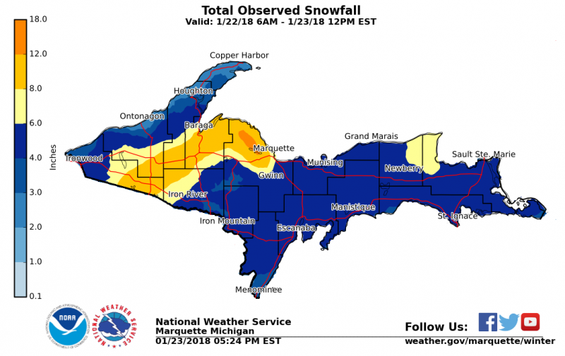
Here's a look at local snowfall totals using dozens of reports received across Upper Michigan on 1/23. The focus of heavier snow occurred across portions of the northwest half of Upper Michigan. A notable maximum in the snowfall also occurred across north-central Upper Michigan as a result of northeast winds interacting with the terrain.
Storm Evolution
Here's a quick look at the meteorology behind the snowstorm (note, this is a bit technical but the loops are still interesting). The storm was a classic "Colorado low", developing below an upper-level trough in the lee of the Rocky Mountains. As the storm deepened, moisture from the Gulf of America was drawn northward toward the Great Lakes leading to very wet and heavy snow. The heaviest snow was found along the northwestern flank of the low coinciding with area of persistent frontogenesis which is quite common with strong mid-latitude low pressure systems.
(Note: Click the loops to view a larger version)
 |
 |
| Loop of 400 - 250 mb potential vorticity (fill), potential vorticity advection (blue and red lines), and 300 mb streamlines. Note the classic "fish hook" shape at the end of the loop, signifying a mature mid-latitude cyclone. | Loop of 300 mb winds (fill, kts), ageostrophic wind (barbs, kts), 500 mb pressure (black lines, mb), and 500 mb layer average omega (e.g. lift; magenta lines). Note the strong along the northern flank of the low pressure system as well as along an arc from Lake Michigan to the Gulf of America. |
 |
 |
| Loop of 700 mb height (black lines, m), wind (barbs, kts), temperature (red and blue dashed lines, C), and 700 to 500 mb mean relative humidity (green shading indicates > 70%). Note the connection to the Gulf of America, as well as the clear "fishhook" structure toward the end of the loop. | Loop of 700 mb height (black lines, m), winds (barbs, kts), and frontogenesis (fill, K/100 km/3 hr). Note the shading along the northern flank of the low pressure system, indicating the location of strongest lift and snowfall. |
As the storm moved into Iowa, it started to occlude, or weaken. However, a convectively-reinforced low pressure system developed in central Illinois and moved northeastward, leading to a band of heavy snow in southeastern Wisconsin (not shown). A few strong thunderstorms also developed across central Illinois and portions of the Ohio River Valley.
Social Media Service
Here's an early look posts made to social media about the upcoming storm.
 |
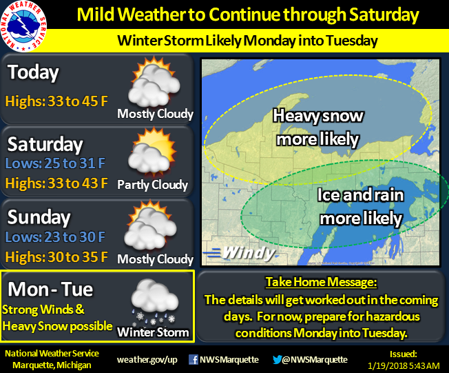 |
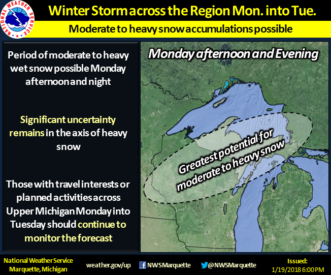
| We first mentioned the possibility of a winter storm on Thursday, January 18th, 2018 highlighting the potential for mixed precipitation types. The exact timing of the storm was kept broad as there was considerable uncertainty in the track and strength of the system. | We continued to highlight the potential for a winter storm on Friday, January 19th again hinting at the possibility of mixed precipitation. Note, however, exact amounts were not discussed as there was still considerable uncertainty in the storm track and intensity. |
 |
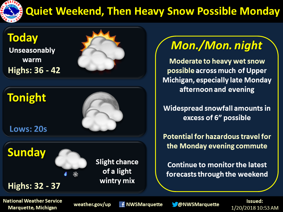 |
| Later during the day on January 19th, confidence increased in predominantly snow across much of the U.P. though with slightly less snow over the Keweenaw Peninsula. While it was becoming more clear that the highest impacts would be felt on Monday and Tuesday, uncertainty still existed in the forecast. | During the morning of Saturday, January 20th, we started highlighting that more than 6" of snow was possible. |
 |
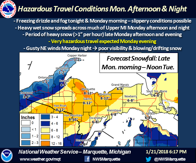 |
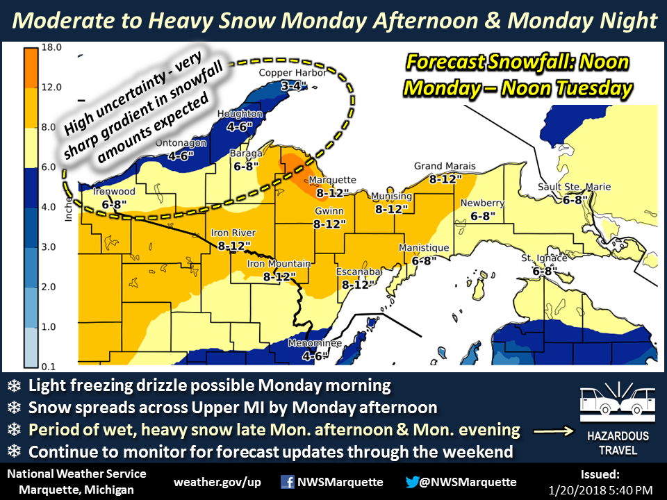
| During the evening of January 20th, we posted our first forecast snowfall map highlighting the potential for a sharp gradient in snowfall across the far western portions of Upper Michigan. The potential for freezing drizzle was also mentioned. Note that a winter storm watch was issued for much of Upper Michigan at this point. | On Sunday, January 21st (one day before the event), our confidence in the track and intensity of the storm increased significantly, with the highest expected snowfall totals falling across north-central portions of Upper Michigan. Snowfall rates in excess of 1"/hr were first mentioned, as well as the potential for gusty northeasterly winds. |
 |
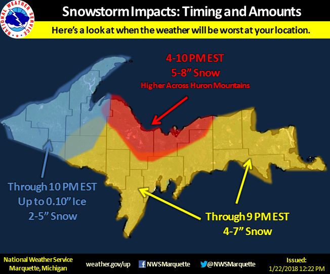 |
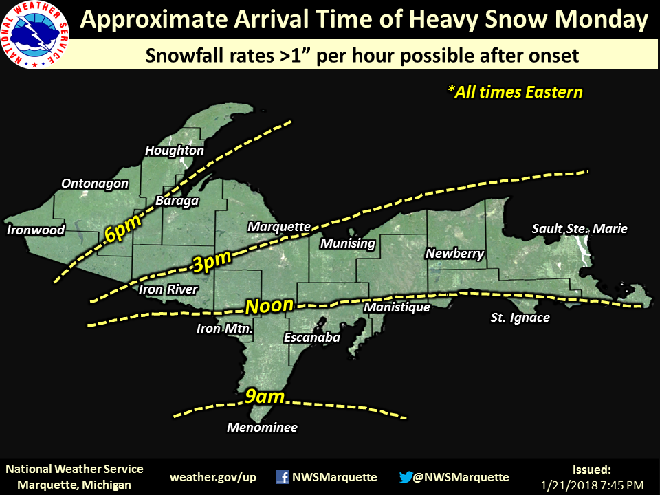
| The night before the storm, we posted a map of approximate start times for the heaviest snow. Again, we reiterated the potential for snowfall rates in excess of 1"/hr. | On Monday, January 22nd, we posted an updated map showing the expected times of the worst weather (and associated snow/ice amounts). |
 |
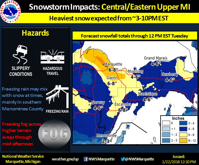 |
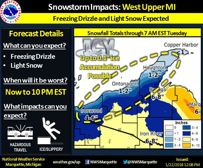
| Additionally, we provided separate graphics for western and central/eastern Upper Michigan on January 22nd (day of event) owing to different expected hazards and time frames of impacts. | Additionally, we provided separate graphics for western and central/eastern Upper Michigan on January 22nd (day of event) owing to different expected hazards and time frames of impacts. |
 |
Media use of NWS Web News Stories is encouraged! Please acknowledge the NWS as the source of any news information accessed from this site. |
|