Winter Storm of March 31, 2018
|
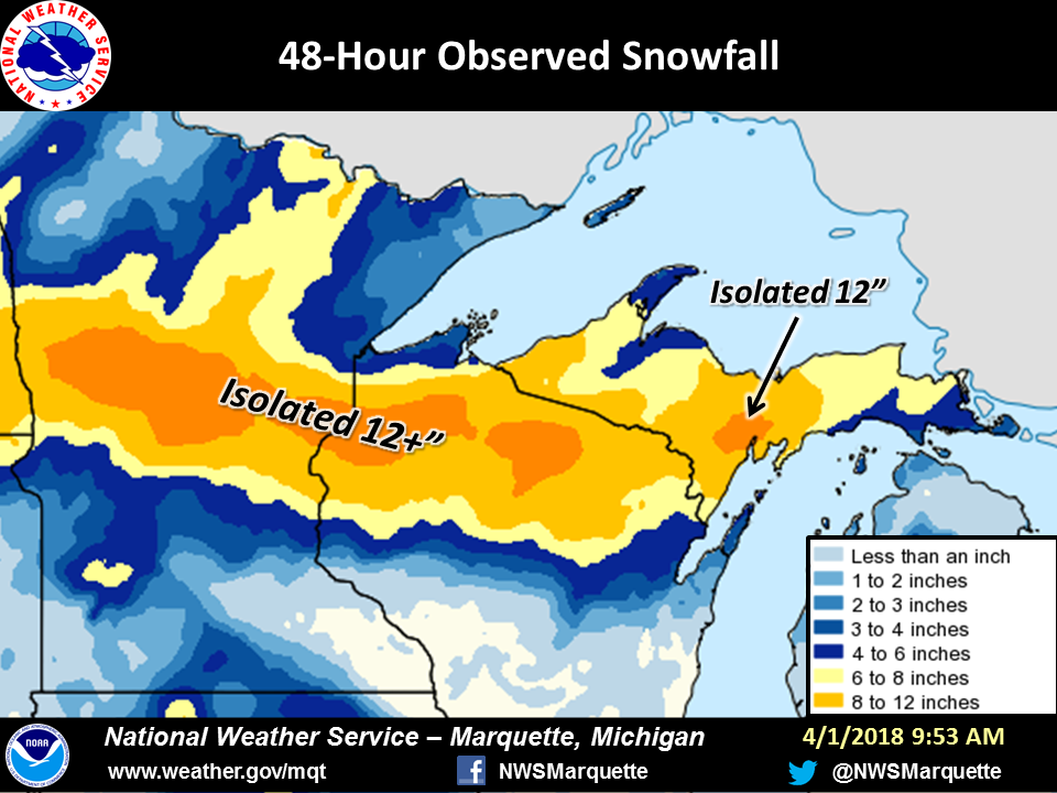
A potent and fast-moving winter storm impacted the western Great Lakes on March 31st dropping a swath of 7 to 10 inches from central Minnesota, northern Wisconsin, and southern Upper Michigan. The snow came down very heavily, with snow falling at rates 1 to 2 inches per hour. In Norway, MI, our CO-OP observer measured 2.7 inches of snow in one hour at peak intensity!
|
|
Snow Reports:
|
           ...48-Hour Snowfall Reports...

       This list is not exhaustive but representative of
       the 2-day snowfall across Upper Michigan.

       Location                     Amount

       ...Alger County...
       6 E Round Lake               9.7 in
       Trenary                      9.0 in
       Munising                     8.0 in
       Eben Junction                5.0 in

       ...Baraga County...
       2 SE Herman                  7.0 in
       1 NW Three Lakes             6.0 in
       Watton                       5.1 in
       Keweenaw Bay                 4.3 in
       Pelkie                       4.0 in
       Watton                       5.1 in

       ...Delta County...
       Escanaba                    12.0 in
       Rapid River                 12.0 in
       Bark River                  11.0 in
       Rock                         0.0 in
       Brampton                     9.5 in
       1 NW Garden Corners          6.0 in

       ...Dickinson County...
       2 SE Vulcan                 10.0 in
       1 SSE Norway                 9.7 in
       5 NNW Iron Mountain          8.3 in
       Channing                     8.0 in
       Felch                        7.0 in

       ...Gogebic County...
       Wakefield                    6.0 in
       Ironwood                     5.8 in

       ...Houghton County...
       Calumet                      3.0 in
       2 WSW Twin Lakes             3.0 in
       1 SSW Allouez                2.0 in
       Houghton                     1.0 in

       ...Iron County...
       Caspian                      9.5 in
       Iron River                   9.0 in
       3 NE Gaastra                 7.1 in
       Alpha                        7.0 in
       Amasa                        6.0 in
       Caspian                      3.5 in

       ...Luce County...
       5 ESE Deer Park              7.0 in
       McMillan                     6.0 in
       6 SSW Dollarville            4.5 in

       ...Marquette County...
       Little Lake                 10.0 in
       Arnold                       8.5 in
       Harvey                       8.0 in
       NWS Marquette                7.5 in
       Trowbridge Park              7.3 in
       Gwinn                        7.0 in
       5 SW National Mine           7.0 in
       10 S Big Bay                 5.0 in

       ...Menominee County...
       Powers                      11.0 in
       1 WNW Spalding               9.7 in
       Daggett                      8.5 in
       Wallace                      7.0 in
       Menominee                    5.5 in
       1 SE Menominee               5.5 in

       ...Ontonagon County...
       Paulding                     4.0 in

       ...Schoolcraft County...
       Manistique                   7.5 in

Observations are collected from a variety of sources with varying
equipment and exposures. We thank all volunteer weather observers
for their dedication. Not all data listed are considered official.

$$
|
(click on the map to view a larger version) |
Social Media Service:
Here's a look at a few of our social media posts leading up to and during the event. Note that clicking on any image will pop-up a larger version.
 |
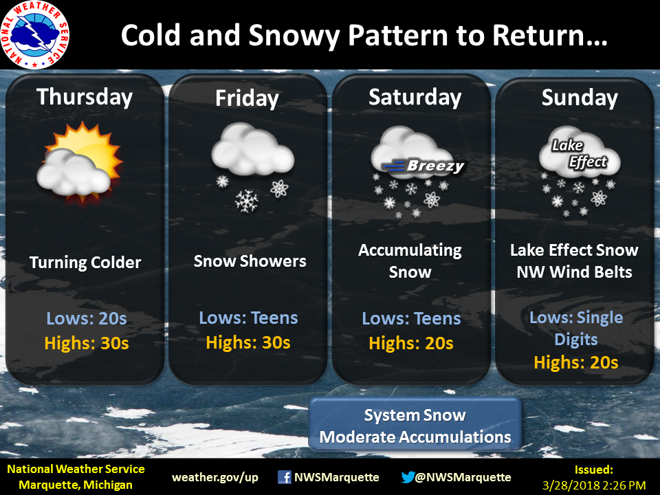 |
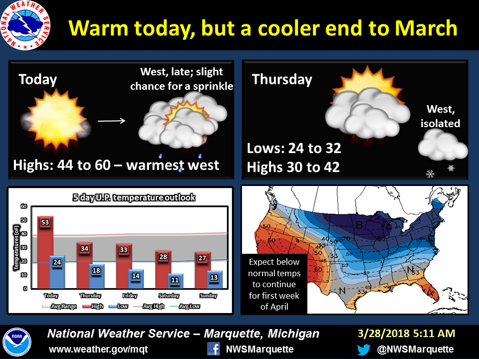
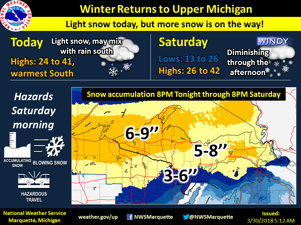
| After a warm march, we first advertised a pattern change during the morning of 3/28, three days before the storm. There was still considerable uncertainty in the path and strength of the storm, preventing an inclusion of potential snow in the post. | By the end of the day on 3/28, confidence increased in the potential for accumulating snow across Upper Michigan. As such, we mentioned the potential for system snow mainly to occur on Saturday. |
 |
 |
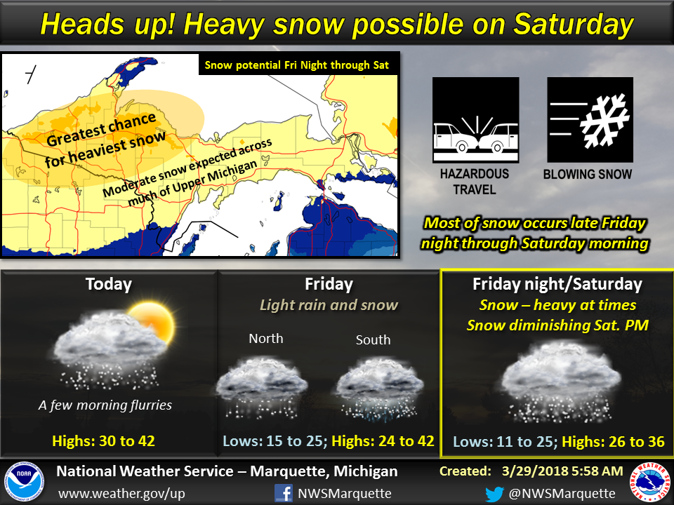
| During the morning of 3/29, we posted a map showing spatially the highest potential for accumulating snow. However, considerable uncertainty still existed in the exact path preventing the inclusion of snowfall amounts in the post. At the time, the greatest chance of accumulating snowfall appeared to be over northwestern Upper Michigan. | A similar map was posted during the evening shift of 3/29 as the forecast had not changed. |
 |
 |
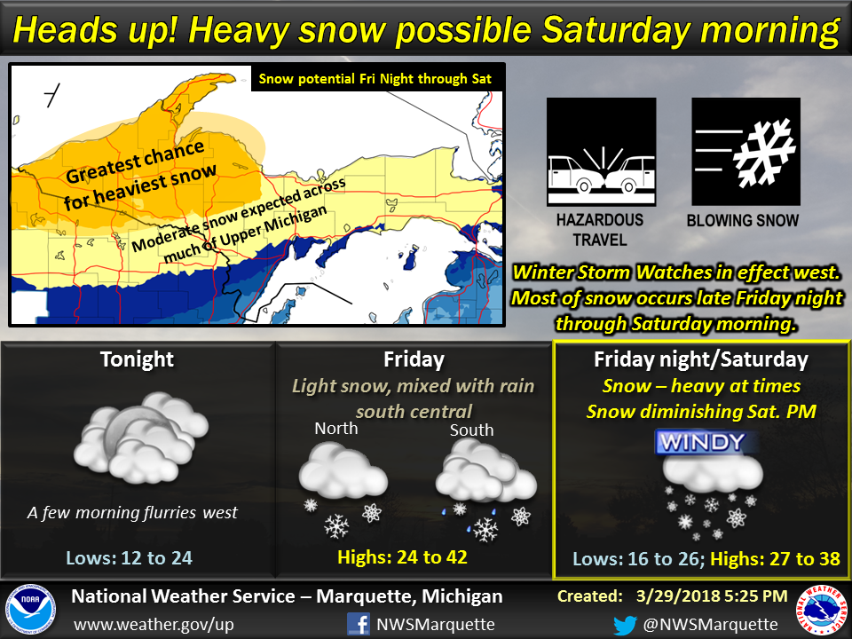
| By 3/30, a day before the event, we felt confident enough to post a map showing potential snowfall amounts. By this point, models have come into agreement with the path and amount of snow for Upper Michigan. | However, the morning of the event, the forecast changed rather dramatically with a 1-county southward shift in the heaviest snow and a slower start time. The forecast change was primarily driven by observations as the low was moving south of the model forecast track. |
 |
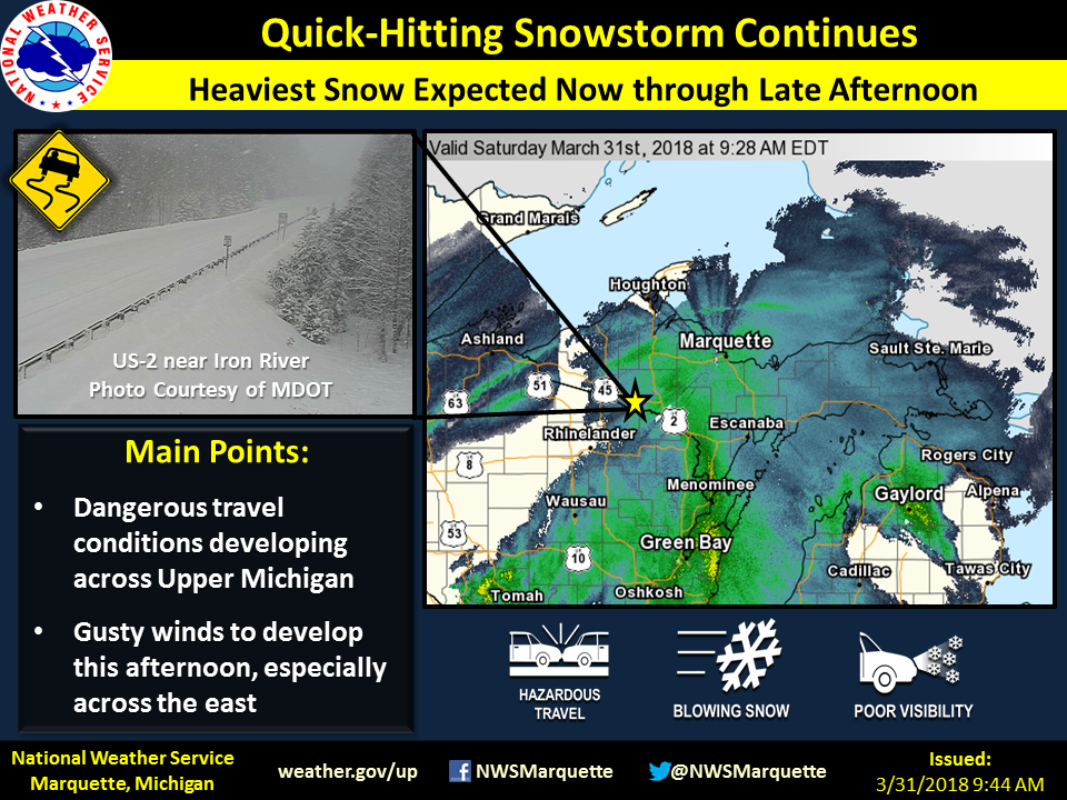 |
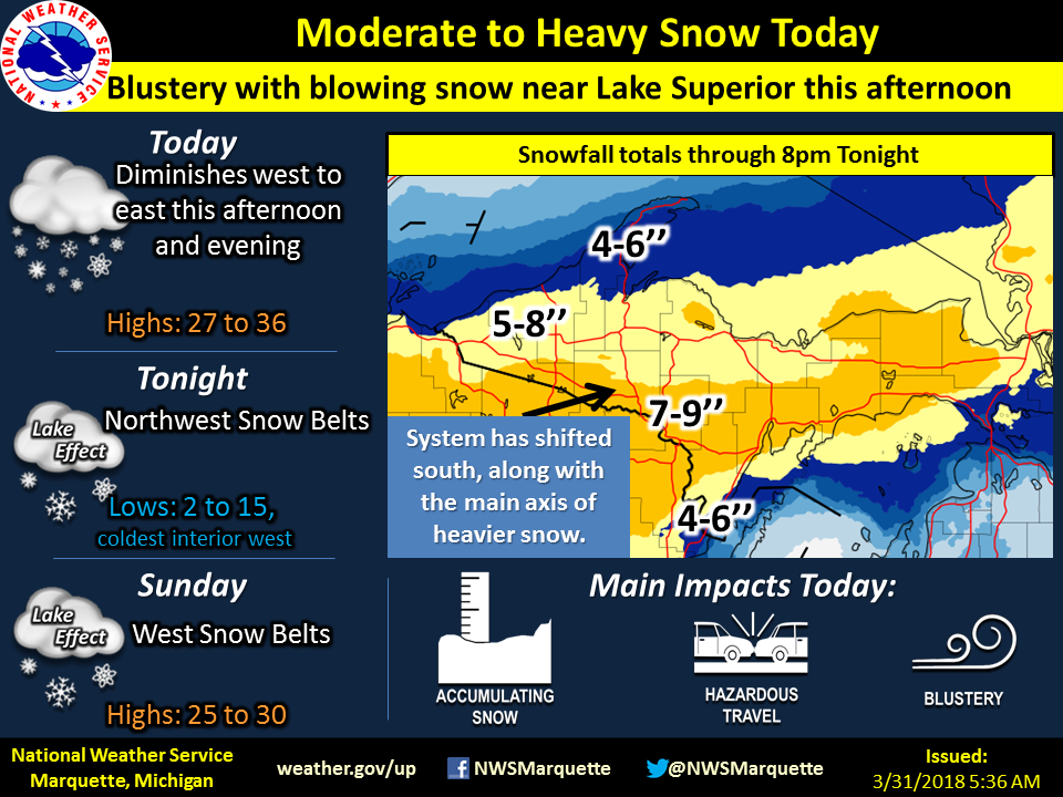
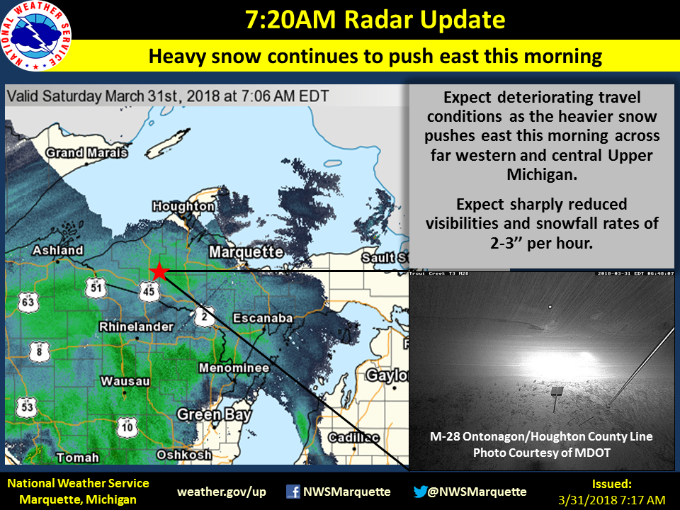
| As the event unfolded, we posted maps showing the locations of the heaviest snow and impacts. White out conditions were reported along major roadways. | As the event unfolded, we posted maps showing the locations of the heaviest snow and impacts. White out conditions were reported along major roadways. |
Meteorology:
Below is an overview of the meteorology behind the widespread moderate to heavy snow. With the majority of the heavy system snow impacting the region between 5 am to 4 pm EDT, comparisons of the atmosphere from the surface up to 300 mb (around 30,000 feet above ground level) at 8 am EDT and 2 pm EDT are shown below to highlight the large-scale and local (e.g. synoptic and mesoscale) features that allowed for localized enhancements of snowfall totals, especially across the southern half of Upper Michigan. Note that clicking on any image will pop-up a larger version.
Note--this overview is a bit technical!
 |
| Regional reflectivity showing the moderate to heavy snow that tracked across Upper Michigan beginning early on in the morning on Saturday, March 31st and lingering into the afternoon hours before beginning to transition to light lake effect behind the system. |
|
|
|
|
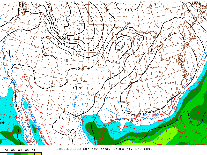
Surface dew point (shaded, F), wind (barbs), and pressure (black lines, mb) at 8:00 AM EDT 3/31. At 8 AM EDT 3/31, a surface low was located over southeastern Minnesota and west-central Wisconsin. This low was the primary driver of heavy snow across Upper Michigan. |
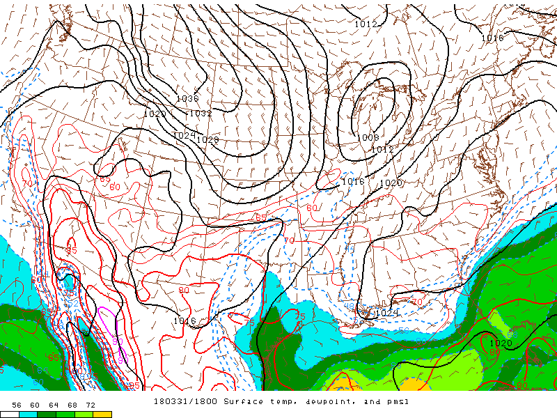
Surface dew point (shaded, F), wind (barbs), and pressure (black lines, mb) at 2:00 PM EDT 3/31. By mid-afternoon, the surface low had tracked across central Wisconsin and across northern Lake Michigan. This track kept much of Upper Michigan in a favorable position for heavy "system" snow. |
 |
 |
|
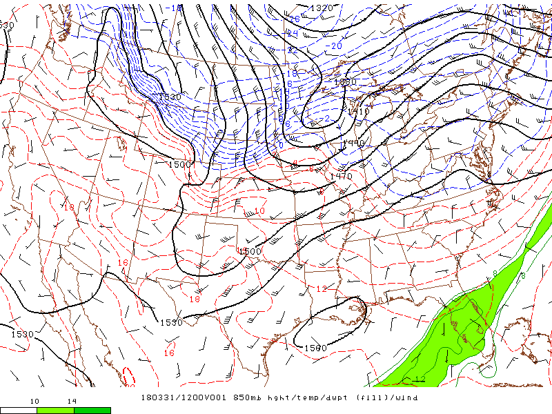
Dew point (shaded, F), temperature (dashed lines, F), wind (barbs), and geopotential height (black lines, m) at 850 mb at 8:00 AM EDT 3/31. At 8 AM EDT 3/31, Upper Michigan was bisected by a 850 mb trough with warm air and moisture advection anchored by a 45-50 knot low-level jet across the western Great Lakes. Cold air advection began to rapidly drop south across the Arrowhead of Minnesota and western Upper Michigan, leading to rapid drying and gusty winds across the region. |
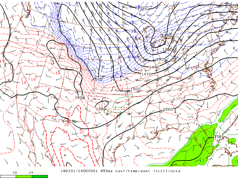
Dew point (shaded, F), temperature (dashed lines, F), wind (barbs), and geopotential height (black lines, m) at 850 mb at 2:00 PM EDT 3/31. By 2 PM EDT, the 850 mb trough had lifted east across the region and cold air advection continued to push eastward across Upper Michigan. At this point, the stronger synoptic-scale lift associated with the warm air advection was beginning to push east of the area leading to a quick reduction in snowfall coverage and intensity. |
 |
 |
|
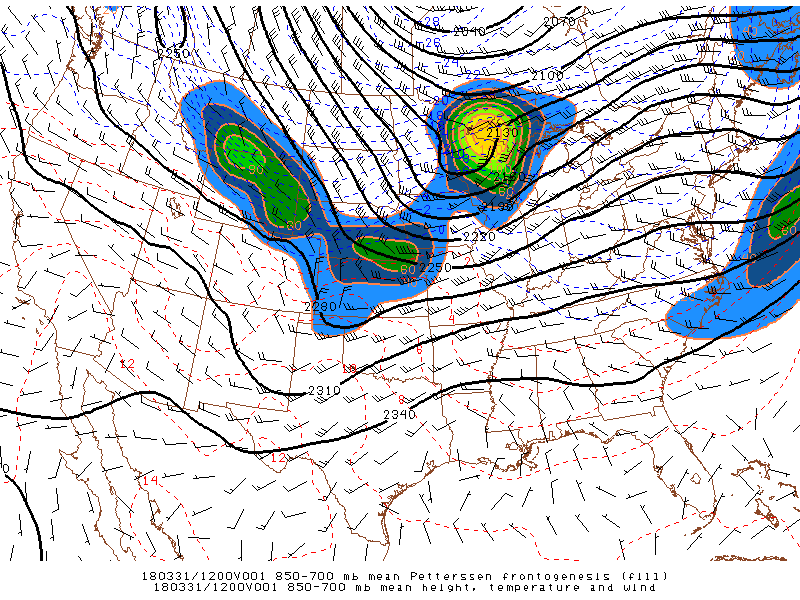
Mean Petterson frontogenesis (shaded), geopotential height (black lines, m), wind (barbs), and temperature (dashed lines, F) between the 850 to 700 mb layer at 8:00 AM EDT 3/31. As the storm moved into Upper Michigan, a strong elevated front tied to the juxtaposition of the strong cold and warm air advection shown (e.g. frontogenetically-forced) continued to push into western and central Upper Michigan. The elevated front allowed for enhanced mesoscale lift across the south half of Upper Michigan, favoring the swath of higher snowfall totals. |
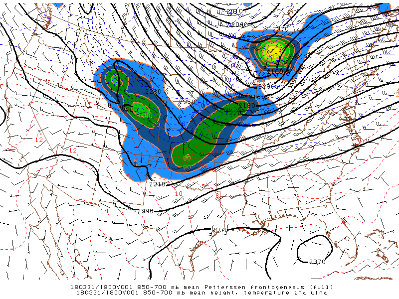
Mean Petterson frontogenesis (shaded), geopotential height (black lines, m), wind (barbs), and temperature (dashed lines, F) between the 850 to 700 mb layer at 8:00 AM EDT 3/31. By 2pm EDT, the elevated front continued to lift northeast as the baroclinic zone, or region of differing temperatures, continued to exit the region and shift over southern Ontario. |
 |
 |
|
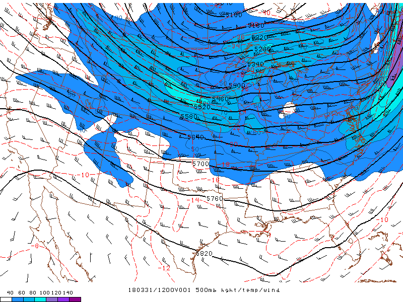
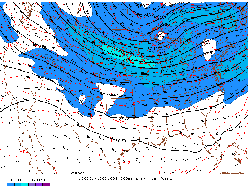
Geopotential height (black lines, m), wind (barbs), and temperature (dashed lines) at 500 mb at 8:00 AM EDT Monday. The storm was supported by upper-level dynamics as evident by the slightly couplet jet streaks over the western Great Lakes at 500 mb. The primary driver of the storm was the shortwave trough over the upper Mississippi River Valley. |
Geopotential height (black lines, m), wind (barbs), and temperature (dashed lines) at 500 mb at 2:00 PM EDT Monday. By 2 PM EDT, the shortwave was further southeast across Minnesota and into lower Michigan, continuing to support large-scale lift across Upper Michigan for widespread system snow. However, the shortwave trough lifted eastward soon after leading to an abrupt ending to the snowfall. |
 |
 |
|
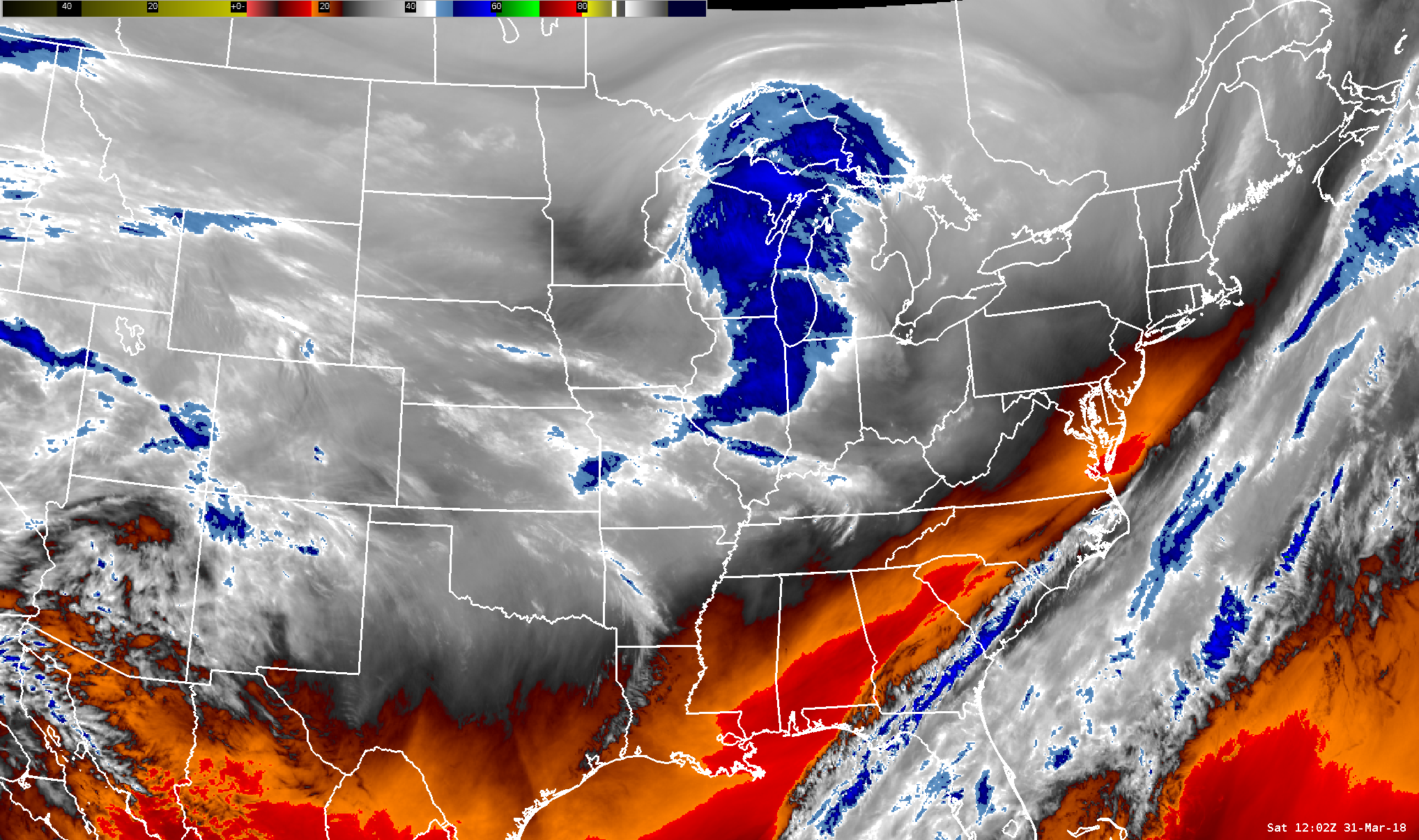
Water vapor imagery at 8:00 AM EDT Monday. The shortwave trough was easily identifiable at 8 AM EDT 3/31 in water vapor imagery as drier air behind the shortwave increased subsidence and drying (warm colors) while large-scale lift combined with mid-level moisture, and thus precipitation, flourished ahead of the feature (cool colors). |
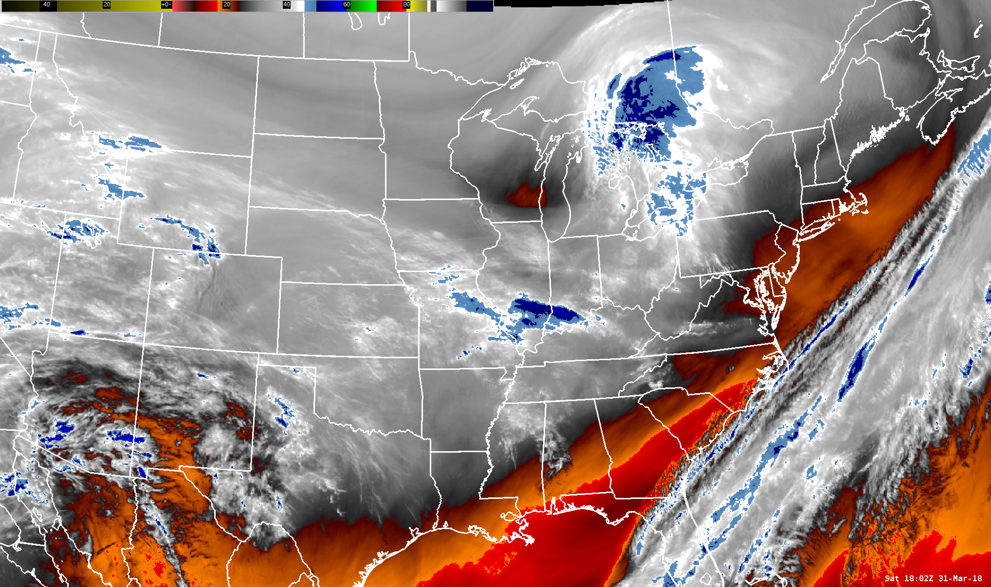
Water vapor imagery at 8:00 AM EDT Monday. The shortwave trough progressed northeastward rapidly leading to rapid drying across Upper Michigan, as seen above. |
 |
 |
|
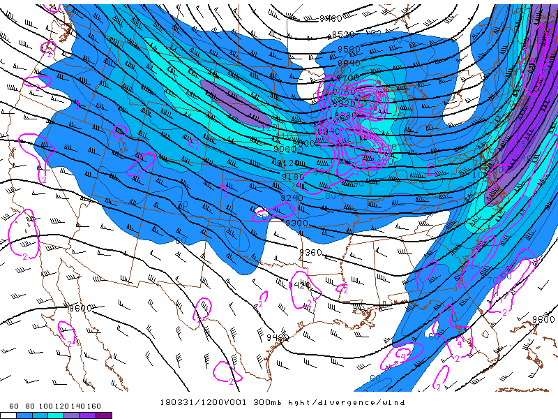
Geopotential height (black lines, m), wind (barbs), and divergance (purple lines, 1/s) at 500 mb at 8:00 AM EDT Monday. At 8 AM EDT, the 300mb analysis showed two jet streaks moving across the region. The positioning of each enabled enhanced lift across the western Great Lakes, as hinted earlier (e.g. coupled jets). Such a feature often leads to rapidly-deepening low pressure systems. |
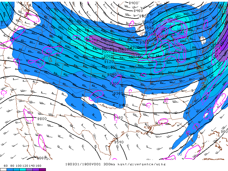
Geopotential height (black lines, m), wind (barbs), and divergance (purple lines, 1/s) at 500 mb at 2:00 PM EDT Monday. By 2 PM EDT, as the shortwave continued to dig across Wisconsin, the coupled jet structure lifted over southern Ontario. |
 |
Media use of NWS Web News Stories is encouraged! Please acknowledge the NWS as the source of any news information accessed from this site. |
|