
Hurricane Dennis - July 10, 2005
 On July 4th in 2005, Dennis formed as a tropical wave near the southern Windward Islands. Dennis strengthened into a tropical storm on the 5th of July as it moved west-northwest across the Caribbean Sea. Strengthening was persistent throughout the day on the 5th, and Dennis intensified into a hurricane early on July 6th.
Over the next few days, Dennis steadily strengthened and intensified into a major hurricane on the 8th of July as it moved just south of Cuba. After Dennis moved across Cuba, it weakened to a Category 1 Hurricane for a short period of time before heading toward the warm waters in the Gulf. Coastal counties from Mobile to Destin were put under a Hurricane Watch at 3pm on July 8th.
For the second time in less than a week and the third time in two months, the area was at risk of a tropical system. Dennis re-strengthened to a Category 4 Hurricane as it traversed across the Gulf toward the northern Gulf Coast. A Hurricane Warning was issued for coastal counties from Mobile to Destin by 3am on the 9th. Slight weakening occurred as Dennis approached the region, just before it made landfall. However, Dennis still made landfall as a Category 3 Hurricane near Navarre Beach, FL at approximately 130pm on July 10th. Dennis moved north-northwest across Santa Rosa County and northeast Escambia County in Florida. The slowly weakening storm then moved into southern Alabama across western Escambia, southern Monroe, eastern Clarke, and northeastern Choctaw Counties.
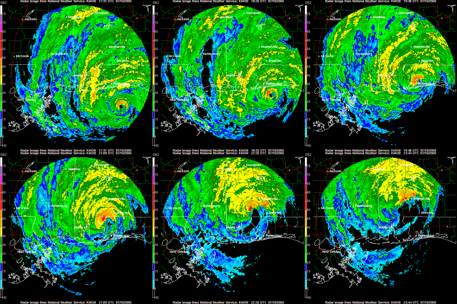
Even though Dennis made landfall as a major hurricane, it was a fast-moving and rather small hurricane, which limited the extent of the impacts closer to the path of the storm. The KMOB (Mobile, AL) radar loop above shows the progression of Hurricane Dennis as it approached the northwest Florida panhandle and moved inland across southwest Alabama. The full track of Hurricane Dennis can be seen in the map below.
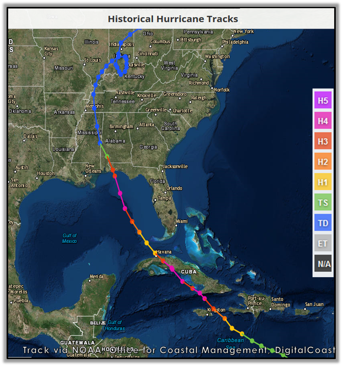
Photo courtesy of NOAA, Office for Coastal Management, DigitalCoast
It was estimated that most of the cotton crop destroyed in northwest Florida was due to the heavy rains and high winds. The cotton crop also suffered damage across southern Alabama. A boat anchored in Cinco Bayou (Okaloosa County, FL) due to Hurricane Dennis was struck by lightning and caught on fire. Firefighters could not get to the boat since it was anchored in the bayou and they had to watch it burn. No one was on board the boat at the time of the fire. The Air Force Bases at Eglin and Hurlburt reported over a half billion dollars in damage from Dennis.
There were zero direct deaths reported with Hurricane Dennis, however, there were 3 indirect deaths reported after the hurricane. 2 deaths were attributed to Carbon Monoxide poisoning in Escambia County, FL and 1 death was attributed to electrocution in Escambia County, AL. **All of the deaths were related to the improper use of emergency generators**
Hurricane Dennis was a smaller, more compact hurricane; thus, the majority of this document will focus on the impacts along the track across the northwest Florida panhandle and southwest Alabama. Below are some of the regional impacts...
Jump to - Wind, Rainfall, Storm Surge, Post-Tropical Cyclone Report, or Additional Information sections.
Satellite imagery courtesy of NASA EarthData. Microbarograph chart from NWS Mobile
Hurricane Dennis had a very small eye and winds around the eyewall caused significant damage as the storm moved north. An aerial survey of the damage showed a 5-10 mile wide area of destruction with most of the damage located east of the eye. As Dennis moved north into Alabama, the damage diminished and was confined to a smaller area. It was noted in the storm survey that a lot of the damage looked like a giant tornado, except the trees were all facing in the same general direction.
The strongest wind gusts associated with Hurricane Dennis occurred along the immediate coastline across the western Florida panhandle. The highest wind gust of 121mph occurred in Navarre Beach (Florida Coastal Monitoring Program tower), where Dennis made landfall. Elsewhere across the western Florida panhandle, wind gusts of 80-100mph were common during the hurricane. The wind graph below shows a peak wind gust of 106mph near 3pm in Pace, FL, as the eyewall from Dennis passed over this location with a drastic drop in winds as the center moved over Pace, then another uptick in the winds with gusts near 90mph on the backside of the eye. For reference, Pace, FL is located approximately 15-20 miles from the immediate coastline.
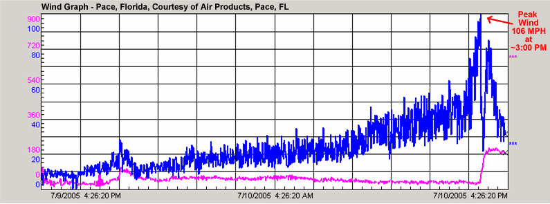
Wind Graph via Air Products in Pace, FL
Significant tree and power line damage, as well as some structural damage, occurred across the entire northwest Florida panhandle. The worst of the damage occurred along the path of the eyewall as it moved inland across Santa Rosa County and the northeast part of Escambia County in Florida. Most of the structural damage to buildings was generally in the area from Navarre to Milton to Jay, FL. Nearly 200 homes in northwest Florida reported major damage.
Further west across the coastal counties of Alabama, the strongest wind gusts were generally 40-50mph, although there were a few hurricane force wind gusts along the immediate coastline. By far, the worst damage occurred across Escambia and Monroe Counties in southern Alabama. High winds in the eyewall blew down numerous trees in the western part of Escambia and the southern part of Monroe County, AL. As was the case in Florida, the cotton crop suffered damage from the heavy rains and high winds.
A list of observed wind gusts from the northwest Florida panhandle and southwest Alabama can be viewed in the table below.
| Location | Wind Gust (knots) | Time (UTC) |
| FLORIDA | ||
| Navarre (near Navarre Bridge) | 105 | 1919 |
| Pace (Air Products) | 92 | 1956 |
| Pensacola | 83 | 1947 |
| Pensacola International Airport (ASOS) | 81 | 2001 |
| Navarre Beach, 2mi E | 78 | 1900 |
| Eglin AFB | 72 | 1940 |
| Niceville, 6mi N | 72 | 1900 |
| Valparaiso, 6mi NW | 71 | 1906 |
| Destin | 70 | 1915 |
| Holt, 12mi SE | 67 | 1932 |
| Destin (ASOS) | 64 | 1853 |
| Niceville | 61 | - |
| Valparaiso, 8mi NE | 57 | 1912 |
| Crestview, 12mi SE | 56 | 2006 |
| Crestview (ASOS) | 50 | 2020 |
| Pensacola NAS | 50 | 1954 |
| Seminole, 4mi N | 50 | 1952 |
| De Funiak Springs, 16mi W | 49 | 2018 |
| Pensacola (WEAR-TV) | 46 | - |
| ALABAMA | ||
| Mobile Bay (USS Alabama) | 67 | 1948 |
| Dauphin Island (DPIA1) | 57 | 1900 |
| Loxley | 43 | 1945 |
| Mobile Regional Airport (ASOS) | 42 | 1800 |
| Lillian | 38 | 1829 |
Wind gusts (in knots) are all from July 10, 2005
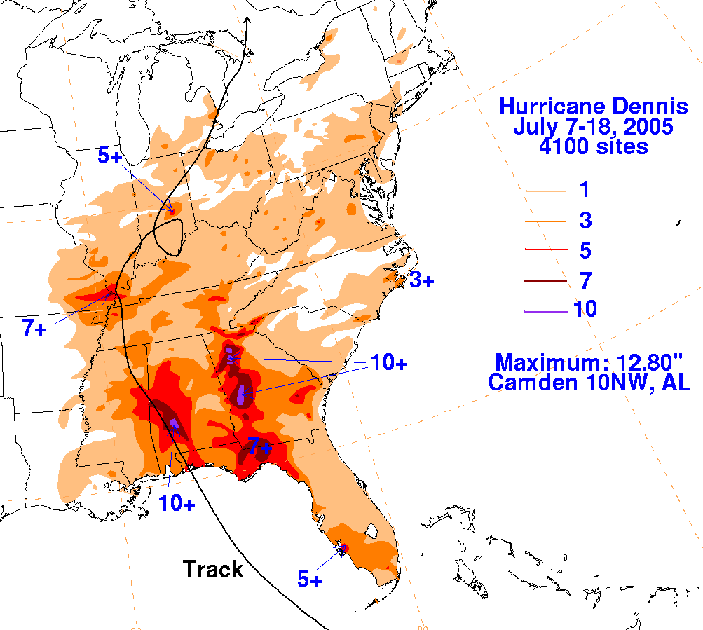 Since Hurricane Dennis was a relatively fast-moving and rather small hurricane, the total rainfall amounts were not as significant as some previous land-falling tropical systems (e.g., 30+ inches of rain with both Hurricane Georges and Hurricane Danny in the late 1990s). In general, storm total rainfall was 3-5 inches across the region as seen in the WPC rainfall graphic on the right.
The highest rainfall amounts were observed along the path of the eyewall of Hurricane Dennis as it moved inland across the western Florida panhandle and into southwest Alabama. Totals along this rainfall swath were in the 5-8 inch range with isolated amounts of 8-10 inches (radar estimated) across the northern part of Escambia County, FL, into Escambia, Monroe, Clarke, and Wilcox Counties in Alabama. Further inland along the path of Dennis, 12.8 inches of rain was reported by an observer northwest of Camden, AL (just to the north of our county warning area).
Major flash flooding occurred along and east of the center of Dennis during the afternoon and evening of July 10th across portions of southwest Alabama and the western Florida panhandle. One of the biggest problems was along I-10 in the Pensacola area, where a portion of the interstate flooded due to poor drainage (construction area at that time). Part of Highway 98 between Fort Walton Beach and Destin in Okaloosa County, FL was washed out from the high water. The westbound lanes on Highway 98 were damaged from the storm surge.
The 48-hour rainfall totals from across the area can be viewed in the table below.
| Location | Rainfall Total (inches) |
| FLORIDA | |
| Pensacola (WEAR-TV) | 7.67 |
| Milton | 7.01 |
| Munson | 6.93 |
| Pace (Air Products) | 6.90 |
| Niceville | 5.15 |
| Niceville, 6mi N | 4.59 |
| Valparaiso, 6mi NW | 4.48 |
| Mary Esther, 6mi W | 4.29 |
| Seminole, 4mi N | 4.29 |
| Milligan | 4.26 |
| Molino | 4.23 |
| Baker | 4.22 |
| Pensacola International Airport | 4.11 |
| Crestview, 15mi SE | 3.64 |
| Ft Walton Beach | 3.62 |
| Holt, 12mi SE | 3.23 |
| Crestview | 3.22 |
| ALABAMA | |
| Bay Minette | 4.56 |
| Butler | 4.36 |
| Semmes | 4.25 |
| Jackson | 4.24 |
| Millers Ferry | 3.82 |
| Andalusia | 3.82 |
| Evergreen | 3.81 |
| Mobile Regional Airport | 3.71 |
| Fowl River | 3.65 |
| Brewton | 3.50 |
| Murder Creek | 3.04 |
48-Hour Rainfall Totals ending at 1159pm July 10, 2005
 Storm surge caused severe beach erosion and coastal flooding across our counties in the northwest Florida panhandle (Escambia, Santa Rosa, Okaloosa) and coastal Alabama (Mobile, Baldwin). Major beach erosion occurred across the northwest Florida beaches from Pensacola Beach to points east of Destin. Minor beach erosion occurred along the Alabama coastline from Dauphin Island to Orange Beach.
A storm tide (storm surge + tide) of 7.10 feet was observed at Fort Morgan, AL, during Hurricane Dennis. Our storm survey team estimated a storm tide height of nearly 6.5 feet in Navarre Beach, FL. Since the eye of Dennis was very small, the highest surge values were near and just to the right of the eye of the storm. Some higher surge values occurred well east of Destin before Dennis moved ashore. The extent of the storm tide can be seen in the image from the National Hurricane Center below. Storm tide flooding occurred along Dauphin Island and the beaches across Baldwin County, as well as around Bayou la Batre and along the Causeway over Mobile Bay.
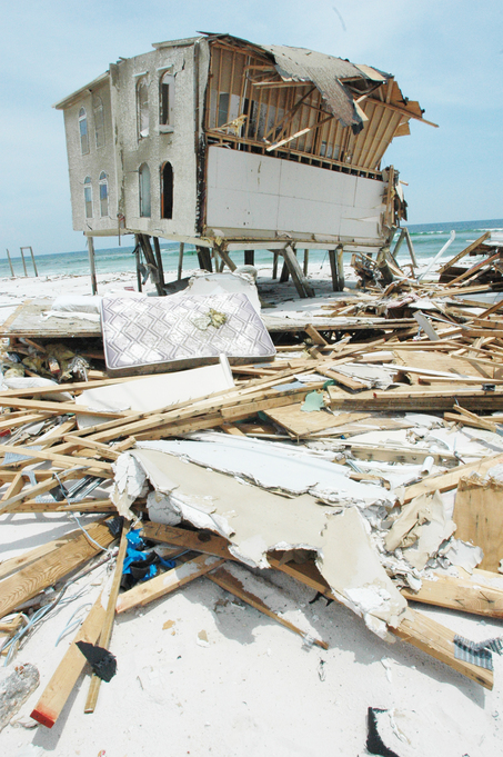
Structural damage due to surge occurred along the coastal portion of all of our counties; however, the damage was most substantial along the Florida coast near Navarre Beach. The combination of wind and storm surge allowed for almost every structure on Navarre Beach to suffer some degree of damage with structures located directly on the beach suffering the most severe damage.
The photo to the right (courtesy of FEMA Photo/Leif Skoogfors) shows the extent of the severe damage due to wind and storm surge in Navarre Beach, FL.
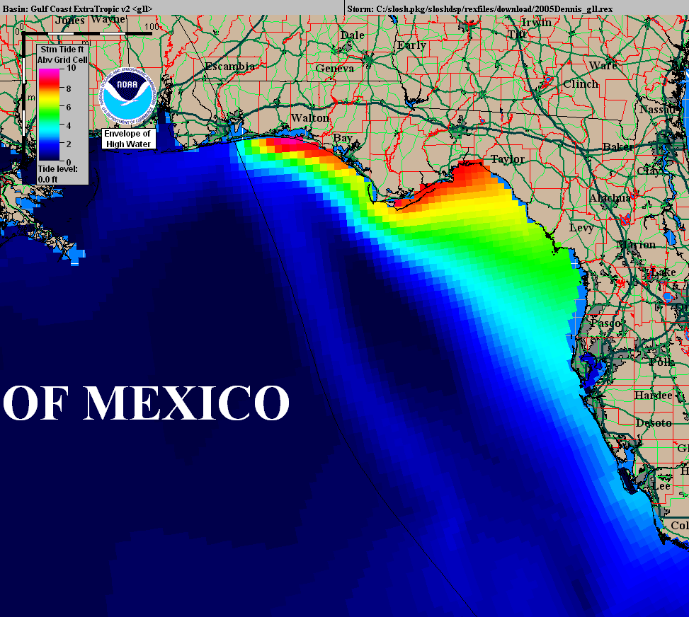
Storm Tide (Envelope of High Water) from Hurricane Dennis via NHC.
POST-TROPICAL CYCLONE REPORT...HURRICANE DENNIS
NATIONAL WEATHER SERVICE MOBILE AL
220 PM CDT THU JUL 14 2005
A. HIGHEST WINDS...
ALL WIND DATA OCCURRED ON JULY 10 2005...
ASOS STATIONS ONLY ENTERED IF WIND GUST 33 KNOTS OR HIGHER...
PENSACOLA AIRPORT (PNS)...
SUSTAINED WINDS 66 KNOTS FROM 270 DEGREES AT 2002 UTC
PEAK GUST 81 KNOTS FROM 260 DEGREES AT 2001 UTC
DESTIN (DTS)...
SUSTAINED WINDS 49 KNOTS FROM 130 DEGREES AT 1929 UTC
PEAK GUST 64 KNOTS FROM 120 DEGREES AT 1853 UTC
MOBILE AIRPORT (MOB)...
SUSTAINED WINDS 32 KNOTS FROM 010 DEGREES AT 1837 UTC
PEAK GUST 42 KNOTS FROM 020 DEGREES AT 1800 UTC
CRESTVIEW (CEW)...
SUSTAINED WINDS 37 KNOTS FROM 120 DEGREES AT 2024 UTC
PEAK GUST 50 KNOTS FROM 130 DEGREES AT 2020 UTC
FLORIDA COASTAL MONITORING PORTABLE MET TOWERS...
NAVARRE (JUST RIGHT OF NAVARRE BRIDGE NEAR HIGHWAY 98)...
PEAK GUST 105 KNOTS FROM 100 DEGREES AT 1919 UTC
PENSACOLA (NEAR ASOS AT PNS)...
PEAK GUST 83 KNOTS FROM 340 DEGREES AT 1947 UTC
DESTIN (NEAR ASOS AT DTS)...
PEAK GUST 70 KNOTS FROM 300 DEGREES AT 1915 UTC
MILITARY SITES...
EGLIN AIR FORCE BASE (VPS)...
SUSTAINED WINDS 48 KNOTS FROM 140 DEGREES AT 1923 UTC
PEAK GUST 72 KNOTS FROM 140 DEGREES AT 1940 UTC
PENSACOLA NAVAL AIR STATION (NPA)...
SUSTAINED WINDS 39 KNOTS FROM 020 DEGREES AT 1750 UTC
PEAK GUST 50 KNOTS FROM 010 DEGREES AT 1954 UTC
BUOY DATA...
DAUPHIN ISLAND (DPIA1)...
SUSTAINED WINDS 42 KNOTS FROM 340 DEGREES AT 1850 UTC
PEAK GUST 57 KNOTS FROM 340 DEGREES AT 1900 UTC
AWS STATIONS ONLY ENTERED IF GUST 33 KNOTS OR HIGHER...
NICEVILLE...
PEAK GUST 61 KNOTS
PENSACOLA (WEAR TV)...
PEAK GUST 46 KNOTS FROM 270 DEGREES
MOBILE BAY (USS ALABAMA)...
PEAK GUST 67 KNOTS FROM 340 DEGREES AT 1948 UTC
LOXLEY ALABAMA...
PEAK GUST 43 KNOTS FROM 360 DEGREES AT 1945 UTC
LILLIAN ALABAMA...
PEAK GUST 38 KNOTS AT 1829 UTC
OTHER STATIONS...
PACE FLORIDA (AIR PRODUCTS) (160 FEET)...
PEAK GUST 92 KNOTS AT 1956 UTC (CENTER PASSED NEAR HERE)
EGLIN AIR FORCE BASE SENSORS IN FLORIDA...
2 MILES EAST OF NAVARRE BEACH (200 FEET)...
PEAK GUST 78 KNOTS FROM 110 DEGREES AT 1900 UTC
6 MILES NORTHWEST OF VALPARAISO...
PEAK GUST 71 KNOTS FROM 100 DEGREES AT 1906 UTC
12 MILES SOUTHEAST OF HOLT...
PEAK GUST 67 KNOTS FROM 120 DEGREES AT 1932 UTC
6 MILES NORTH OF NICEVILLE...
PEAK GUST 72 KNOTS FROM 110 DEGREES AT 1900 UTC
12 MILES SOUTHEAST OF CRESTVIEW...
PEAK GUST 56 KNOTS FROM 130 DEGREES AT 2006 UTC
16 MILES WEST OF DE FUNIAK SPRINGS...
PEAK GUST 49 KNOTS FROM 140 DEGREES AT 2018 UTC
4 MILES NORTH OF SEMINOLE...
PEAK GUST 50 KNOTS FROM 120 DEGREES AT 1952 UTC
8 MILES NORTHEAST OF VALPARAISO...
PEAK GUST 57 KNOTS FROM 130 DEGREES AT 1912 UTC
B. LOWEST PRESSURE...
ALL OCCURRED ON JULY 10 2005...
MOBILE REGIONAL AIRPORT (MOB) - 990.5 MB AT 2228 UTC
PENSACOLA REGIONAL AIRPORT (PNS) - 956.6 MB AT 1952 UTC
SEMMES ALABAMA - 991.2 MB AT 2130 UTC
CRESTVIEW (CEW) - 989.5 MB AT 2009 UTC
EGLIN AFB (VPS) - 986.1 MB AT 1923 UTC
PENSACOLA NAS (NPA) - 976.6 MB AT 1956 UTC
PENSACOLA (WEAR TV) - 968.5 MB
MOBILE BAY (USS ALABAMA) - 987.8 MB AT 2137 UTC
LILLIAN ALABAMA - 986.8 MB AT 2127 UTC
MOBILE BAY (MIDDLE BAY LIGHT) - 989.8 MB AT 2100 UTC
DAUPHIN ISLAND (DPIA1) - 991.2 MB AT 2105 UTC
C. RAINFALL...
RAINFALL TOTALS ARE 48 HOUR TOTALS ENDING AT 1159 PM JULY
10 2005...
ASOS SITES...
MOBILE REGIONAL AIRPORT (MOB) 3.71 INCHES (6 HOUR TOTAL
1.86 INCHES ENDING AT 2200 UTC JULY 10)
PENSACOLA (PNS) 4.11 INCHES (6 HOUR TOTAL 3.10 INCHES ENDING
AT 2059 UTC JULY 10)
CRESTVIEW (CEW) 3.22 INCHES
NWS COOP SITES...
BAY MINETTE 4.65 INCHES
BREWTON 3.50 INCHES
EVERGREEN 3.81 INCHES
JACKSON 4.24 INCHES
NICEVILLE 5.15 INCHES
OTHER SITES...
SEMMES 4.25 INCHES
PENSACOLA (WEAR TV) 7.67 INCHES
PACE (AIR PRODUCTS) 6.90 INCHES
BAKER 4.22 INCHES
MILLIGAN 4.26 INCHES
MILTON 7.01 INCHES
MOLINO 4.23 INCHES
MUNSON 6.93 INCHES
FORT WALTON BEACH 3.62 INCHES
6 MILES W OF MARY ESTHER 4.29 INCHES
6 MILES NW OF VALPARAISO 4.48 INCHES
12 MILES SE OF HOLT 3.23 INCHES
6 MILES N OF NICEVILLE 4.59 INCHES
4 MILES N OF SEMINOLE 4.29 INCHES
15 MILES SE OF CRESTVIEW 3.64 INCHES
BREWTON 3.04 INCHES
FOWL RIVER 3.65 INCHES
MILLERS FERRY 3.82 INCHES
MURDER CREEK 3.04 INCHES
ANDALUSIA 3.82 INCHES
BUTLER 4.36 INCHES
D. STORM TIDES...
HIGHEST TIDES OCCURRED ON JULY 10 2005...UNLESS OTHERWISE STATED
TIDES ARE GIVEN IN MSL...
PERDIDO PASS 4.10 AT 1933 UTC
PENSACOLA 5.50 AT 2000 UTC
MOBILE STATE DOCKS 4.00 AT 0618 UTC ON 7/11 (*)
SANTA ROSA SOUND 5.00 AT 2024 UTC
DESTIN 4.60 AT 1940 UTC
CEDAR POINT 3.50 AT 1746 UTC
BAYOU LA BATRE 3.64 AT 0320 UTC ON 7/11 (*)
DAUPHIN ISLAND 4.00 AT 1900 UTC
MOBILE (MIDDLE BAY) 3.64 AT 0441 UTC ON 7/11 (*)
FORT MORGAN 7.10 AT 1800 UTC
PACE (AIR PRODUCTS) 3.50
NAVARRE BEACH STORM SURVEY SURGE ESTIMATED AT 6 TO 6.5 FEET
(*)- TIDES WERE HIGHEST IN MOBILE BAY AS WINDS BECAME ONSHORE
AS DENNIS MOVED INLAND
E. BEACH EROSION...
MAJOR BEACH EROSION OCCURRED FROM PENSACOLA BEACH TO EAST OF
DESTIN. MINOR BEACH EROSION OCCURRED FROM DAUPHIN ISLAND TO
ORANGE BEACH.
F. FLOODING...
SOME STORM TIDE FLOODING OCCURRED ON DAUPHIN ISLAND AND THE
BEACHES OF BALDWIN COUNTY...AS WELL AS AROUND BAYOU LA BATRE
AND ALONG THE CAUSEWAY. MAJOR FLASH FLOODING OCCURRED IN
SOUTHWEST ALABAMA AND PARTS OF NORTHWEST FLORIDA.
G. TORNADOES...
SEVERAL WEAK TORNADOES MAY HAVE OCCURRED NEAR THE EYEWALL OF
DENNIS OVER SANTA ROSA AND ESCAMBIA COUNTIES OF FLORIDA...AND IN
ESCAMBIA...CLARKE AND MONROE COUNTIES OF ALABAMA.
H. STORM EFFECTS...
SIGNIFICANT TREE AND POWER LINE DAMAGE...AS WELL AS SOME
STRUCTURAL DAMAGE...OCCURRED ALONG THE PATH OF THE EYEWALL.
ALMOST EVERY STRUCTURE ON NAVARRE BEACH SUFFERED SOME KIND OF
DAMAGE...WITH STRUCTURES LOCATED ON THE BEACH DAMAGED THE
MOST SEVERELY. AN ESTIMATED 1.8 MILLION PEOPLE EVACUATED FOR
DENNIS. AN ESTIMATED 400 THOUSAND PEOPLE WERE WITHOUT POWER. NO
DIRECT DEATHS REPORTED FROM DENNIS...BUT THERE WERE THREE
INDIRECT DEATHS AS OF JULY 14 (2 FROM CARBON MONOXIDE POISONING
AND 1 FROM ELECTROCUTION). PRELIMINARY DAMAGE ESTIMATES FROM
DENNIS COULD APPROACH A BILLION DOLLARS.
BEELER/SHEPHERD
NHC Advisory Archive
WPC Archive
NHC Tropical Cyclone Report - Hurricane Dennis
NOAA Coastal Aerial Photos
NWS Local Write-Ups and Webpages:
NWS Birmingham
NWS Huntsville
Acknowledgements: Page created by Morgan Barry (forecaster) and Don Shepherd (Senior Forecaster, Tropical Focal Point).
LAST UPDATED: July 2025