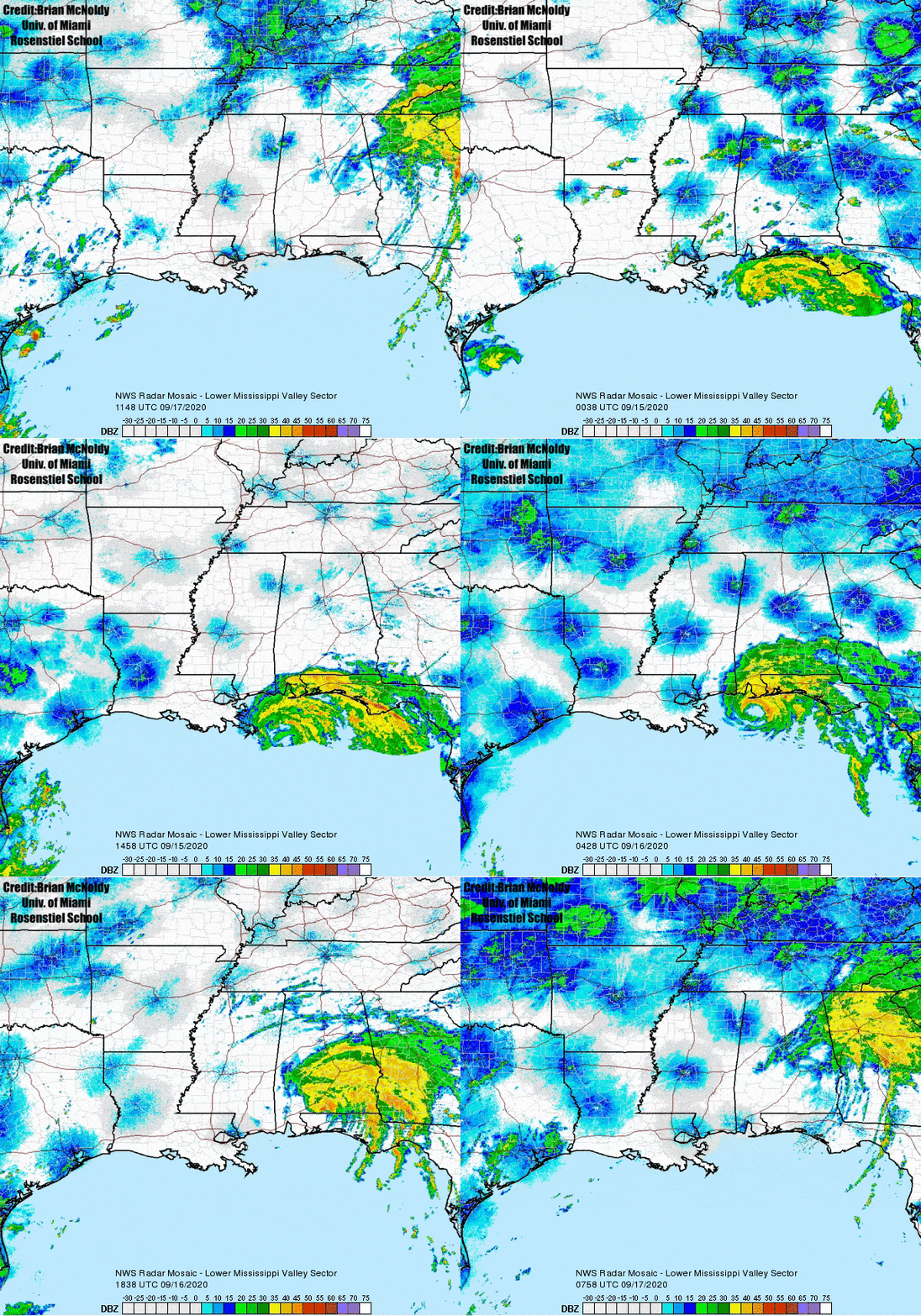
On September 16, 2020, slow-moving Hurricane Sally made landfall causing significant wind and historic flood damage across the Weather Forecast Office Mobile’s Area. Sally presented numerous forecast challenges in the days prior to landfall including a slow erratic track, and a period of rapid intensification through landfall. These characteristics resulted in significant impacts including several hours of winds in excess of 125 m/s (80 mph), rainfall amounts over 73 cm (29 in), and total water inundation up to 3 m (9 ft) across coastal Alabama and the western Florida Panhandle. The goal of this review is to provide forecasters valuable information when forecasting wind and water impacts for slow moving hurricanes. The following detailed meteorological analysis will assess the factors that led to strengthening prior to landfall and potential model and meteorological signals that could aid forecasters along the Gulf Coast.
Jump to - Forecast Challenges, Sea Surface Temperatures, Synoptic Influences, Takeaways, References or Additional Resources sections.

Tropical cyclone Sally presented challenges with respect to both movement and intensity. Sally was a tropical storm as of 0000 UTC, 14 September 2020, with maximum sustained winds of 50 knots while positioned over the northeast Gulf of America. The model ensemble guidance at the time (0000 UTC, 14 September 2020) was suggesting a bimodal distribution of forecast solutions with two potential outcomes as shown in Figure 1. These two potential outcomes presented forecasters with very different but plausible outcomes which would have direct implications on the forecast of local impacts from rainfall, wind, and storm surge.
Figure 1: 0000 UTC Sept 14 2020 GEFS ensemble run colored by intensity
One cluster of forecast model track and intensity guidance suggested that Sally would remain a weaker cyclone due to increased effects from increasing westerly shear and potential upwelling (see discussion below) due to slow cyclone movement just prior to landfall. The model projection of stronger shear and a resultant weaker, shallow cyclone (Velden and Leslie, 1991) likely had a significant impact on the projected westward clustering of forecast cyclone tracks. As suggested by Velden et. al., a shallow, weaker cyclone would be steered by the low level wind flow. The low level wind flow surrounding Sally at the time was from the east southeast (need an image showing low level wind flow) which would result in a more westward track, as suggested in the first clustering of model ensemble member track guidance.
The second clustering of model forecast track and intensity guidance for Sally suggested a much stronger, deeper cyclone with less impact from shear and upwelling (see discussion below) and a further east track solution. As was suggested by Velden et. al., deeper and stronger cyclones are steered by deep layer flow surrounding the cyclone. A stronger and deeper cyclone projected by the second clustering of model ensemble members likely resulted in the more eastward shift of track guidance.
Tropical Storm Sally remained a weak and shallow cyclone through the evening of 13 September 2020. In fact, the cyclone was only being reflected below on analysis charts below 500mb (include graphic figure). Sally was initially forecast to track westward to a position southeast of the Louisiana coastline as it was embedded within low level easterly flow established across the northern Gulf of America, before curving northward in response to an approaching mid and upper level trough (include graphic figure). This forecast solution was supported by a cluster of westward tracking ensemble members. This was to the south of an upper level anticyclone centered across the Southeast United States (add figures of both 250mb analysis and low level analysis *850mb?* from 00z 14 Sept). At 0000 UTC, 14 September 2020, Sally retained maximum sustained winds of 50 knots and had changed very little in organization or intensity during the previous twenty four hours with only minor intensification.
Sally underwent an initial period of rapid intensification (need a reference for rapid intensification) between 1200 UTC and 1800 UTC 14 September 2020. Sally intensified to a hurricane during this six hour period with winds increasing from 50 knots to 85 knots. The overall environment during this time period remained favorable for intensification, with a period of light shear, upper level ridging to the north, and warm sea surface temperatures (include graphics from 12 UTC on the 14th showing this environment). This intensification period was well forecasted by the National Hurricane Center and was reflected in tropical cyclone discussions through this time period. It is hypothesized that this initial phase of intensification played a role in the eventual track and intensity of Sally upon landfall. The stronger, deeper cyclone at 1800 UTC, now reflected through 250mb in upper air analysis (add graphic figure), may have been an important clue as to why the ensemble model guidance from 0000 UTC 14 September 2020, was showing the second clustering of model ensemble members which showed a stronger and deeper cyclone tracking further east. The eventual track and intensity of Sally through landfall likely supports this hypothesis.
The overall intensity of Sally was also potentially influenced by an approaching mid latitude trough over the Southern Plains.
.png/Sally_Synoptics.pptx%20(6)__480x270.png)
.gif/ezgif.com-gif-maker%20(14)__480x270.gif)
00Z Sep 13th sounding from Slidell. LA 300 hPa analysis from Sep 13th through Sep 16th
An upper level trough centered over the Southern Plains lifted northeast into the Middle-Mississippi Valley on 15 September 2020.. This trough began to induce 10 to 12 m/s (20 to 25 knots) of shear on the western periphery of Hurricane Sally (Figure showing this in graphic). Studies have shown that storms impacted by moderate shear in an idealized environment struggle to intensify and or weaken with time as the inner vortex forms asymmetries (Frank and Ritchie, 2001). Typically, in a sheared environment, stronger convection is typically favored on the downshear side which can help pull the vortex downshear or in this case north-northeast. Despite the presence of moderate shear impinging onto the hurricane, Sally did not weaken during the slow final approach to the coast. It is hypothesized that a 30 m/s (60 knot) upper level jet streak analyzed at 250 hPa moving across the Tennessee Valley provided a favorable environment for intensification of the hurricane (Figure with image). This was due to the fact that Sally became located beneath the right entrance region of the upper level jet streak, which supported enhanced divergence aloft. This likely supported the robust convective bursts that were noted on GOES 16 Clean IR satellite imagery with convective cloud tops cooling significantly (Figure add satellite image) and may have offset the influence of any disruptive shear.
In addition, near term model guidance began to show further intensification and the potential for some significant intensification leading up to landfall. By 00 UTC on 16 September 2020, despite the presence of moderate upper level shear, Sally began a final period of rapid intensification. Through landfall as suggested by the rapidly strengthening eyewall structure observed from KMOB radar (Figure - include radar image).
GFS 10 m wind speed and MSLP
.png/Sally_Synoptics.pptx%20(9)__600x338.png)
250 hPa analysis with 60 knot jet streak over Tennessee
.png/Sally_Synoptics.pptx%20(7)__480x270.png)
.png/Sally_Synoptics.pptx%20(8)__480x270.png)
0000 UTC Sep 14th sounding from Birmingham, AL 1200 UTC Sep 15th sounding from Birmingham, AL
Sea Surface Temperature Impacts
Deep water upwelling is always a consideration for determining tropical cyclone intensity. Conceptually, hurricanes upwell water from below through Ekman processes which could lead to periods of little intensification or even slight weakening and studies have shown that slow moving intense hurricanes have the greatest upwelling effects (Price, 1981). Studies during the CBLAST project have numerically shown the impacts of cold water upwelling across the Tropical Atlantic with data from Hurricane Frances (2004) showing a decrease in surface temperature of almost 2.2 degrees C and .4 degrees C under the cyclones center, which resulted in changes in the air-sea heat fluxes and intensity (D'Asario et al, 2007) (Black et al, 2007). However, Sally intensified significantly in the final ten hours through landfall despite the impacts of upwelling and potentially significant upwelling due to the storm's slow forward motion (2 to 4 m/s).
Research from the Dauphin Island Sea Lab (Dzwonkowski, et al., 2020) suggests that early season tropical cyclones may precondition deep layer warm sea temperatures by overturning warm near surface seawater with colder deep seawater. Deep colder water, which is mixed to the surface, is warmed by strong solar radiation resulting in deep warm water reaching down to great depths. Therefore, any later season cyclones that are slow moving and travel over this deep layer of warm water will simply upwell warm water and negate any negative effect of “cold-water” upwelling. This potentially occurred with Sally and may have contributed to model guidance that trended towards significant intensification through landfall.
Data analyzed from NDBC Buoy 04012, which is located approximately 12 miles south of Gulf Shores and passed through the center of Sally, did show that upwelling did occur throughout the lifespan of the cyclone. Sea surface temperatures (SST's) were measured around 29.5 C at 0600 UTC, 14 September 2020, which was near the season high sea surface temperatures at this location. SST's dropped to 28.6 C by 1800 UTC, 15 September 2020 as the storm slowly approached the station. As the center of the storm passed over the station during the peak of the systems 2nd rapid intensification phase, pressures fell to a minimum of 970 hPa and waters had only cooled to 28.5 C ( -0.1 C). By the time the storm made landfall and began to depart the area, sea surface temperatures had fallen to approximately 27.9 C on September 1800 UTC on the 17th. Over the two-day period from September 15th to September 17th in which the storm had passed over the buoy, SST's fell 1.7 degrees C. While this appears to be a significant drop, studies have shown that intensification and intensification rate increases significantly around or above the 27-degree C mark meaning that sea surface temperatures remained conducive for continued intensification (Xu et al, 2016). It is also important to note that sea surface falls during the peak of the storm were only about .1 C compared to the .4 degrees C noted with a stronger (60 m/s vs. 45 m/s) but quicker moving (7 m/s vs. 3 m/s) Hurricane Francis (Black et al, 2007). Given that tropical cyclone max wind speed is dependent on the flux of enthalpy (Emmanuel, 2003), these differences in cooling rate and high SST temperature possibly played a role in allowing Sally to perform rapid intensification despite the notion that slow-moving cyclones increase surface upwelling.
.png)
NDBC Bouy 04012 temperature and pressure data for Hurricane Sally
Several key takeaways were concluded from the events of Sally and the meteorological re-analysis. The first takeaway was that several meteorological factors led to periods of rapid intensification and steady track changes throughout Sally's lifespan. While other unknown meteorological factors could have also influenced the track and intensity of Sally, three primary factors were recognized in the re-analysis, (1) the presence of enhanced upper level divergence within the right entrance region of an upper level jet streak across the Tennessee Valley which aided downshear convection and likely influenced the northeastward track shift in Sally, (2) the likely presence of deep warm water upwelling as referenced by the Dauphin Island Sea Lab, and (3) the presence of weak but sufficient southwesterly steering flow aloft which steered the stronger cyclone further towards the northeast than initially predicted. These meteorological conditions resulted in rapid forecast changes within the final 48 hours through landfall.
As a result, to the aforementioned rapid forecast changes, messaging challenges became more apparent as the greatest wind and surge threats quickly shifted east within the final 24-48 hours (during and beyond the preferred period of finalizing decisions). These changes quickly removed some areas from significant wind and surge impacts while also significantly increasing the impacts across other areas. Along with the wind and surge impacts, the "bullseye" of a well forecasted historic flooding rainfall event quickly shifted east from the Mississippi Gulf coast. The changes in the precipitation forecast potentially lead to the exacerbate of the combined hydrological (surge + rain) impacts along the coast. This complicated decision making for some coastal partners as changes occurred within partners critical planning period.


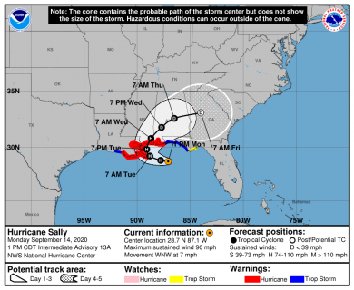
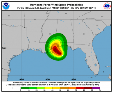
18Z UTC Sep 14th NHC track cone 18 UTC Sep 14th 64 Knot wind speed probabilities
Lastly, storm surveys revealed concerns over confusing messaging between watches/warnings and the public's understanding of the forecast cone. Forecast areas near landfall were under Hurricane watches and warnings for 48 to 72 hours prior to landfall, which in theory would result in preparedness actions being taken for the potential of hurricane conditions. However, several peopled interviewed during surveys voiced they felt under prepared and were caught off-guard by the intensity and quick changes in the forecast cone. While this was only a very small anecdotal sample size and a more robust social science public study would be likely be required, the surveys did bring potential concerns on how tropical cyclones with high track and intensity uncertainties are messaged. While the meteorological factors may have varied between deterministic model guidance and the end results were different, an ensemble approach to forecasting would have at least give forecasters the ability to recognize the potential for significant strengthening and adjust messaging towards the potential of a higher impact wind and surge event. The further education and use with partners and the public of probability products such as probability of winds and Psurge could potentially help mitigate confusions with slow moving tropical cyclones where rapid messaging changes could occur.
NHC Advisory Archive
National Geodetic Survey Emergency Response Imagery
USGS Flood Event Viewer for Hurricane Sally
NWS Local Write-Ups and Webpages:
NWS New Orleans
NWS Tallahassee
NWS Birmingham
Acknowledgements: Page created by Brandon Black (Forecaster), Jonathan Howell (Science Operations Officer) and Jason Beaman (Warnings Coordinating Meteorologist).
LAST UPDATED: August 2021