
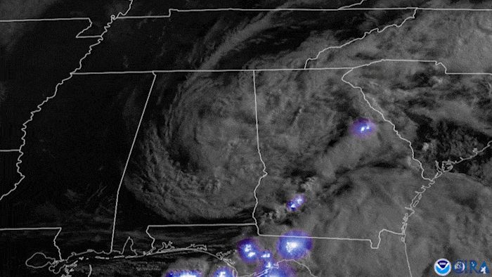
Summary of all Local Storm Reports (LSRs) across the area during Tropical Storm Claudette, as well as all the LSRs across the region for this event (regional map may take a minute to load).
Tropical Storm Claudette made landfall well west of our area, but impacts were felt across the entire region. Below are some of the local impacts...
Jump to - Rainfall, Wind, Storm Surge, Tornado, Post-Tropical Cyclone Report, or Additional Information sections.
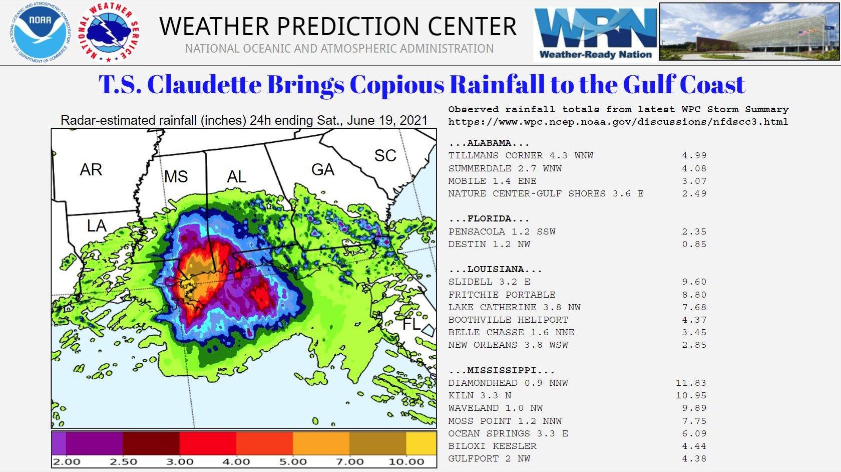
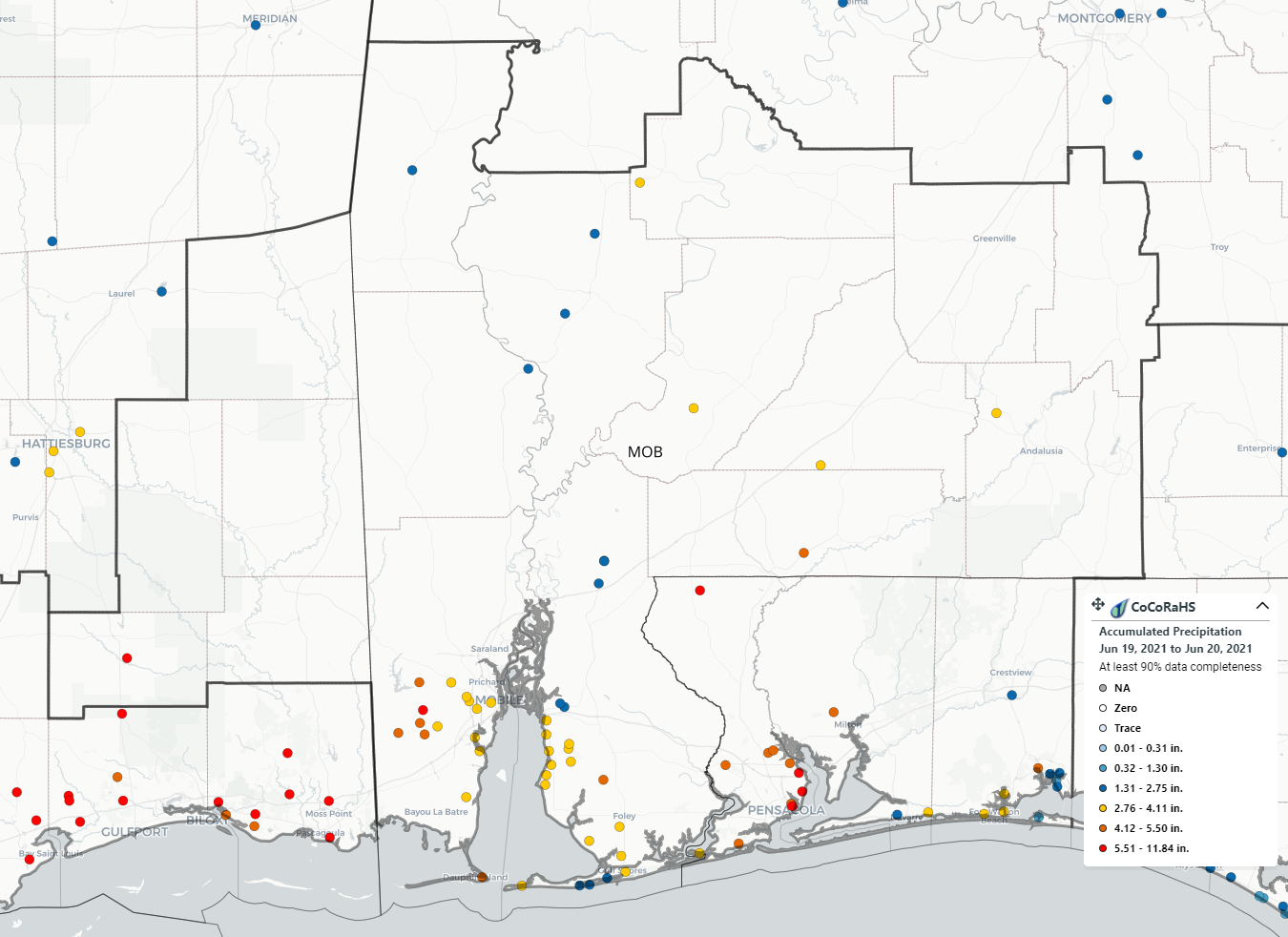
A detailed listing of rainfall totals can be found at the following link: Tropical Storm Claudette Storm Total Observations
Tropical Storm Claudette produced frequent tropical storm-force wind gusts across coastal Alabama and the western Florida Panhandle. A few areas of the coast, such as Dauphin Island, Fort Morgan, and the Okaloosa Island Fishing Pier recorded a brief period of sustained minimal tropical storm-force winds.
The highest wind gusts were associated with strong to severe thunderstorms that develop well east of the center of Claudette. These storms most significantly impacted the western Florida Panhandle. The highest wind gust observed was 81 mph at Pensacola International Airport. A Weatherflow site in Santa Rosa Sound recorded a 70 mph wind gust, which was from the same line of storms that resulted in the Pensacola gust. This line of storms produced wind damage in parts of the Pensacola Metro, especially in Ferry Pass. Pace also experienced pockets of wind damage, including one mobile home that lost its roof.
The following is a comprehensive listing of land and marine winds/peak gusts (mph) and times of occurrence. The first table lists the Automated Surface Observing Systems (ASOS), while the second table lists observations from other data collection platforms, including marine, WeatherFlow, and DoD ASOS.
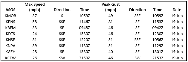
Table 1
KMOB- Mobile Regional AP; KPNS- Pensacola International AP; KBFM- Brookley Field, Downtown Mobile AP; KDTS- Destin/Ft. Walton Beach AP;
KNSE- Whiting Field, Milton, FL; KNPA- Navy Pensacola; KGZH- Middleton Field AP, Evergreen, AL; KCEW- Sikes AP, Crestview, FL
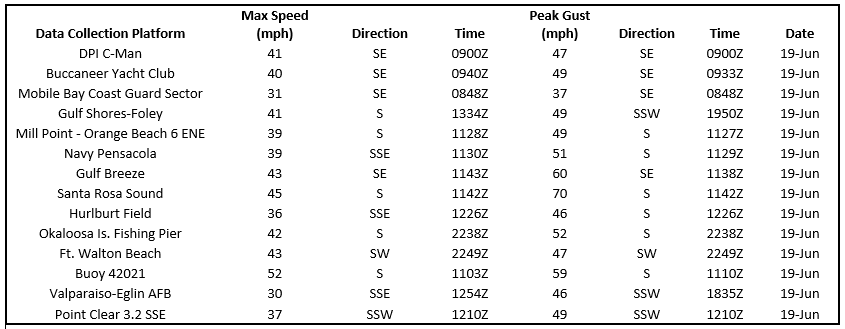
Table 2
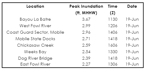
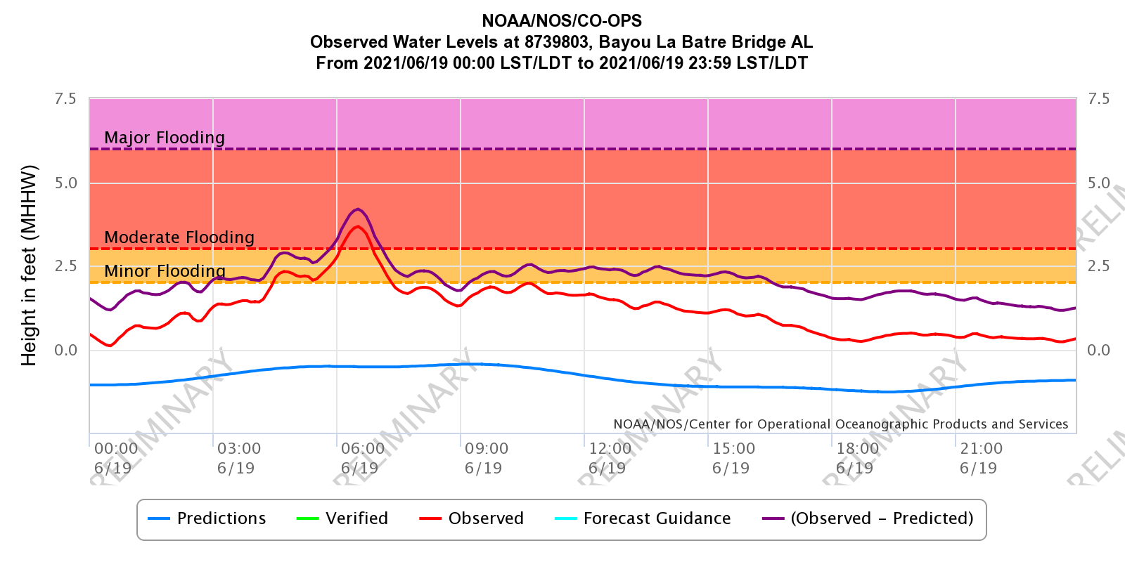
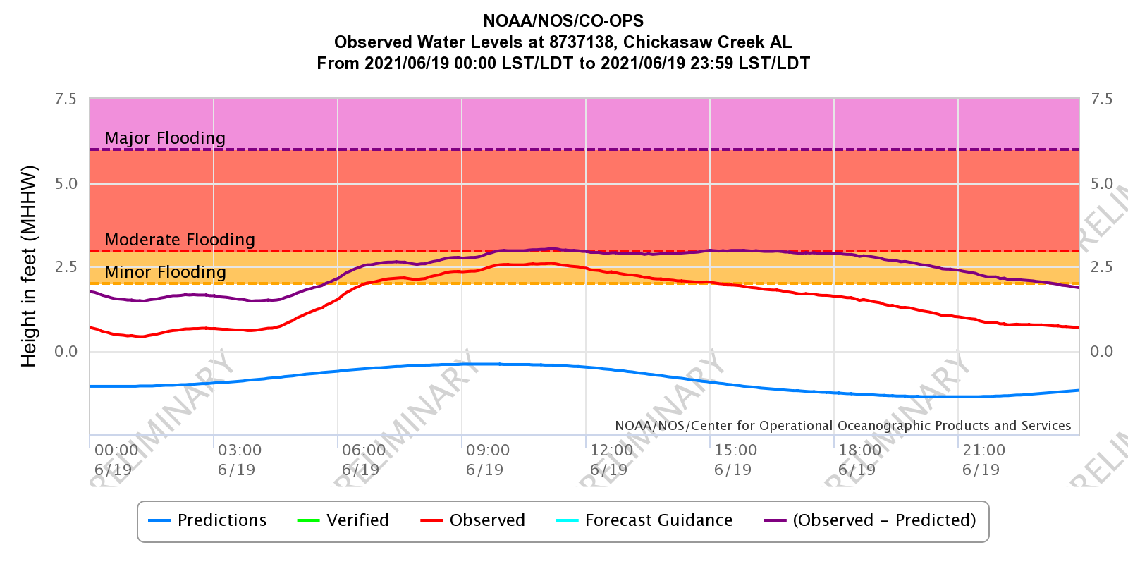
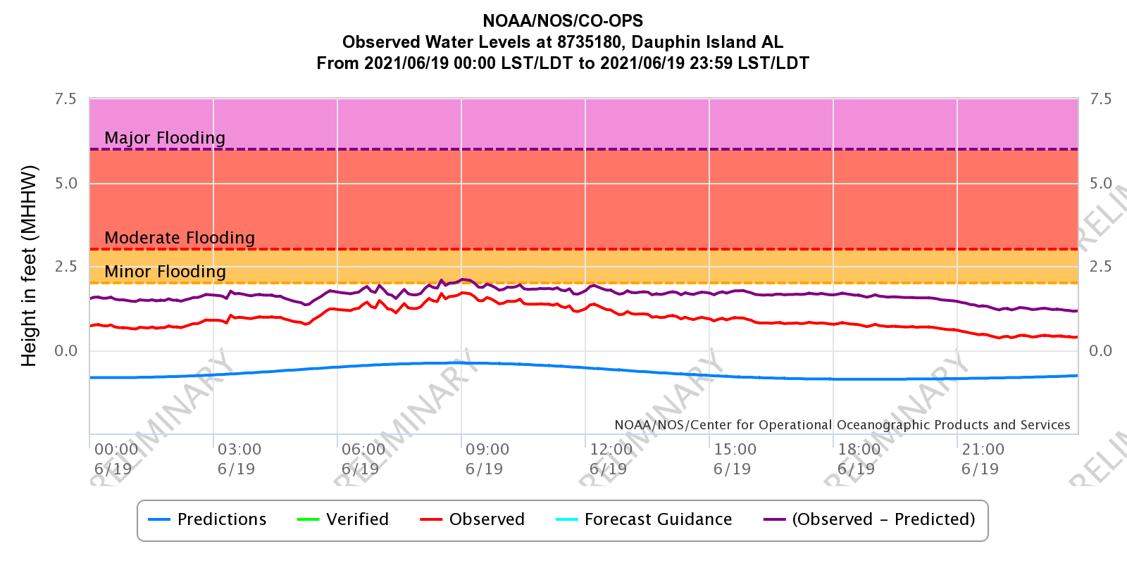
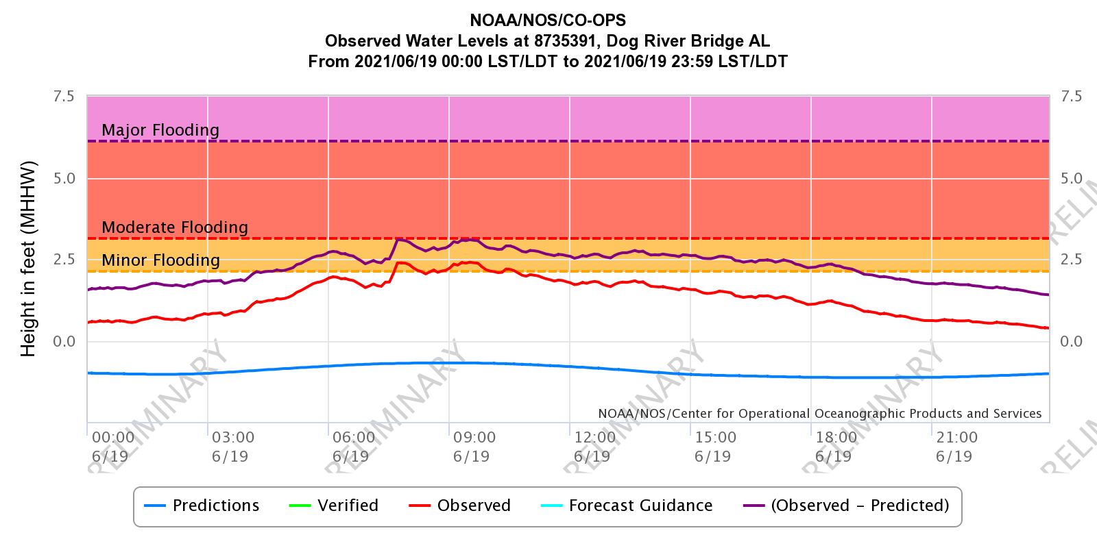
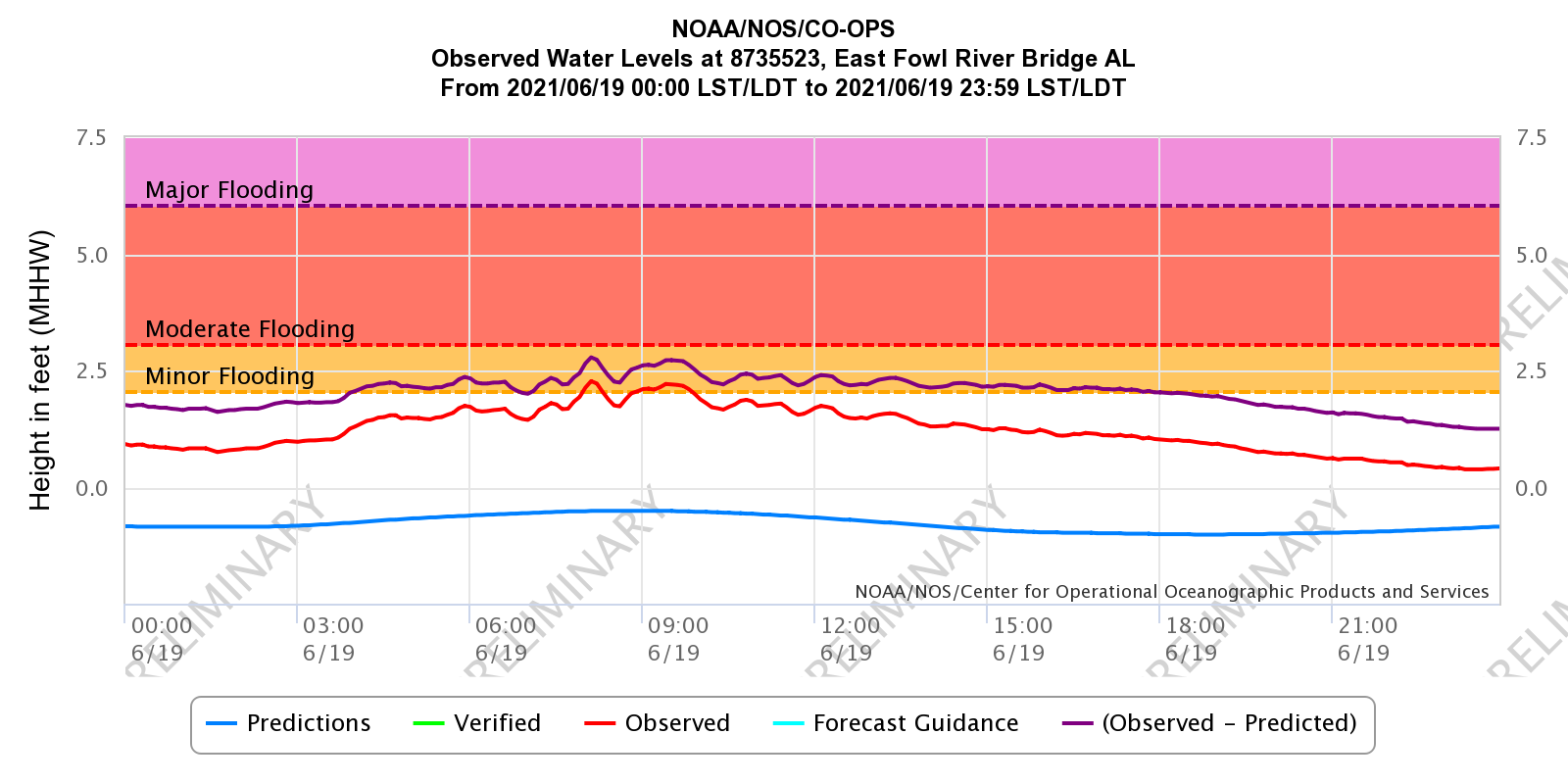
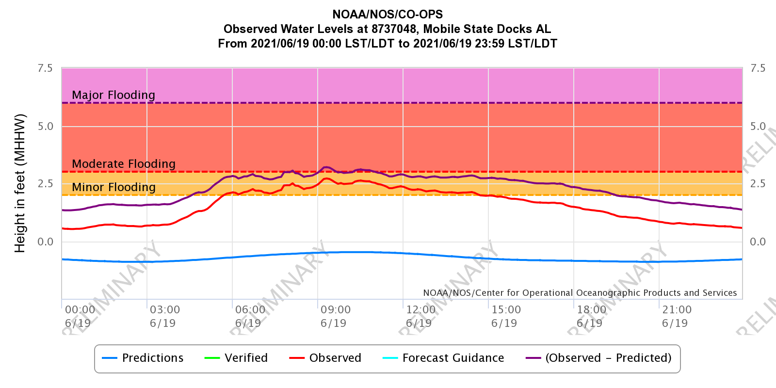
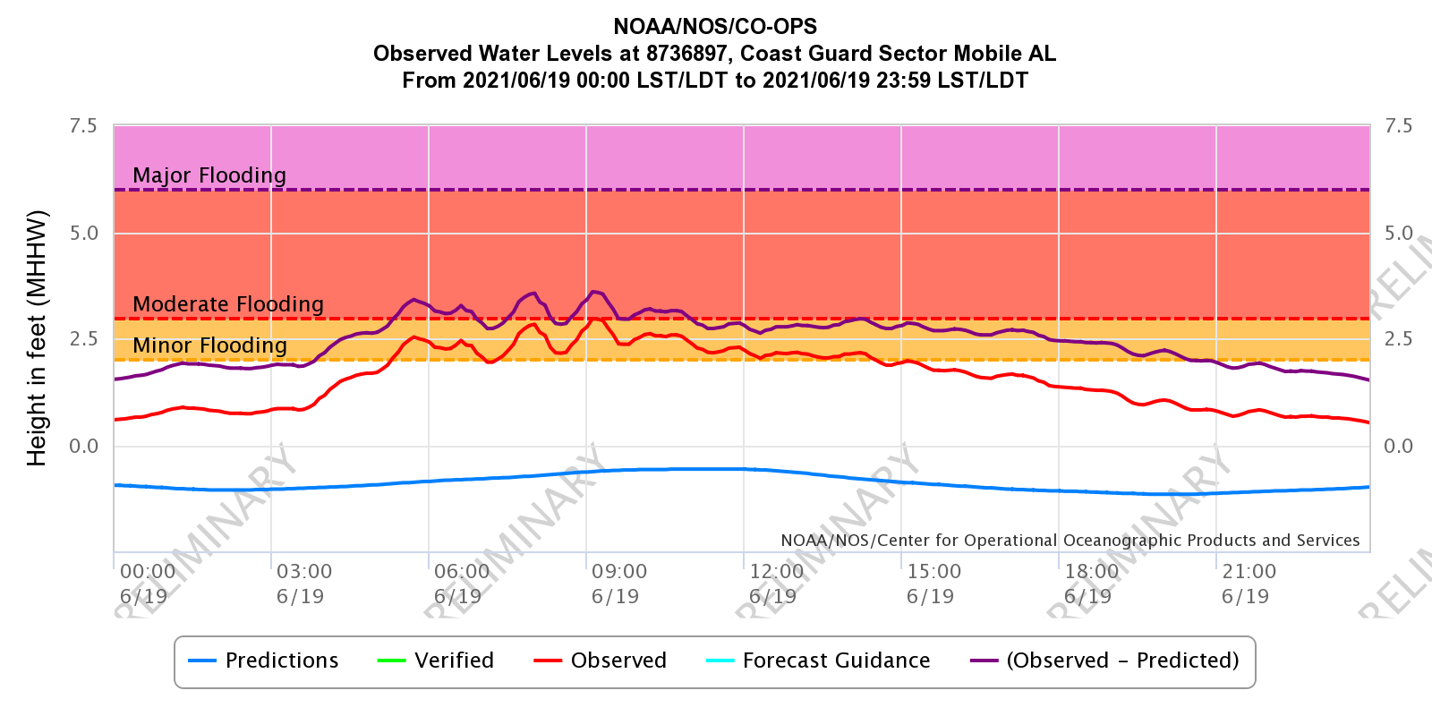
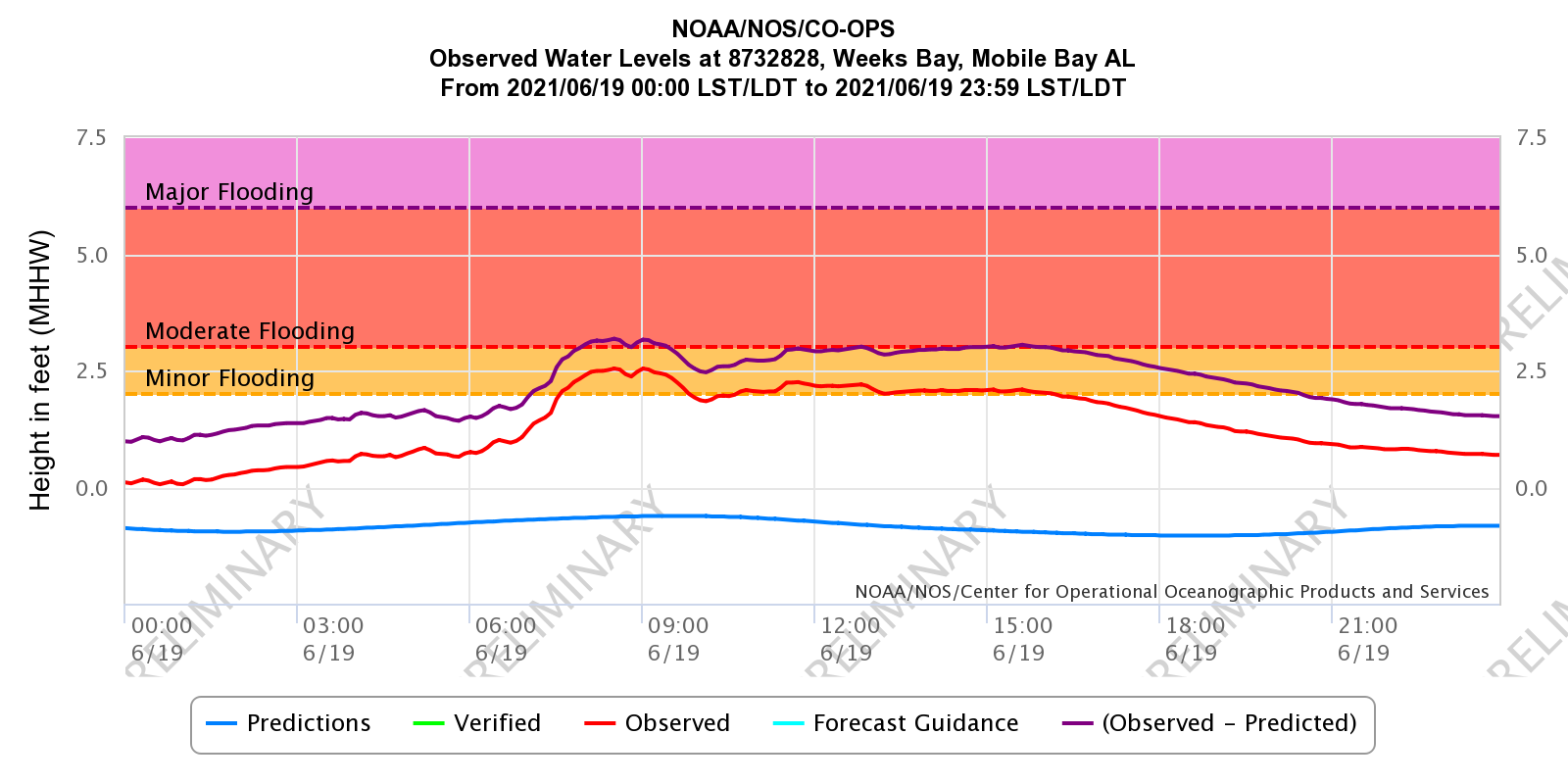
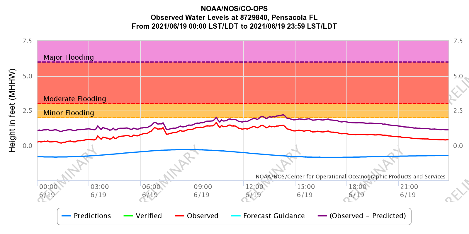
Storm surge inundation ranged from 1-3 feet across southern Mobile County into Mobile Bay. This flooding resulted in the closure of a few roads, such as Shell Belt Rd in the Bayou La Batre and Coden communities and the US Highway 90 Causeway over Mobile Bay. In addition to the storm surge, surf heights of 6-12 feet battered the Gulf facing beaches. This impacted the west end of Dauphin Island with a portion of Bienville Blvd closed due to flooding and sand over the road. The Florida side of the Gulf Islands National Seashore was closed for several days due to flooding and sand on roads.

Claudette spawned several tornadoes and waterspouts across the area, including a significant tornado in Escambia County, AL. Survey teams found damage consistent with a 22+ mile long EF-2 tornado that greatly impacted the East Brewton community and points northward into Conecuh County, AL. Emergency management reported up to 20 injuries, most of which were minor with two serious injuries. The tornado first touched down in the Riverview community and intensified/widened as it moved northeast into East Brewton. Some of the most severe damage was located at Forrest Ave and Andrew Jackson St where several mobile homes were completely destroyed. This tornado also produced significant roof damage to the auditorium at W S Neal High School. Major tree damage and major structural damage continued along the path to the northeast. A single-wide mobile home was completely destroyed with the owner thrown from the building and found near the frame over 100 yards away. The tornado continued into Conecuh County with spotty EF-0 to EF-1 damage all the way north to the I-65 near the rest area. The tornado is estimated to have lifted just north of the rest area.
A new EF-1 tornado was confirmed in eastern Conecuh County, AL to the northwest of the Johnsonville community. This tornado was on the ground for 4.16 miles and downed numerous trees in a densely forested region inaccessible to ground survey crews. The tornado was discovered via high-resolution satellite imagery.
An EF-0 tornado was confirmed in southeast Covington County, AL to the northwest of the Florala community. This tornado was on the ground for 3.72 miles and downed numerous large trees limbs with a few small trees snapped.
The survey team also investigated the reported wind damage in the Ferry Pass and Pace communities. The team noted pockets of enhanced wind damage in these areas, but could not identify any convergent damage paths that would indicate a tornado. Estimated straight-line wind speeds were in the 60-80 mph range. Pensacola International Airport gusted to 81 mph and the Santa Rosa Sound recorded a 71 mph wind gust.
Another EF-0 tornado was confirmed near the Cedar Point Pier in southern Mobile County, AL. The pier suffered damage to railings and light poles and a large metal storage unit was lifted and heavily damaged during this very brief tornado. A 2x4 was launched through the window of a pickup truck and the occupant of the truck suffered minor injuries. The endpoint is an estimation as the tornado could have continued to the north, but the area is a marsh and the survey team was not able to find a definitive endpoint.
Thanks to our emergency management partners for helping us survey these tornadoes and straight-line wind swaths after Tropical Storm Claudette.
A compilation of the tornado surveys and further information can be found on this supplementary webpage.
POST TROPICAL CYCLONE REPORT...TROPICAL STORM CLAUDETTE
NATIONAL WEATHER SERVICE MOBILE AL
848 PM CDT TUE JUN 29 2021


NOTE: THE DATA SHOWN HERE ARE PRELIMINARY....AND SUBJECT TO UPDATES
AND CORRECTIONS AS APPROPRIATE.

THIS REPORT INCLUDES EVENTS OCCURRING WHEN WATCHES AND/OR WARNINGS
WERE IN EFFECT...OR WHEN SIGNIFICANT FLOODING ASSOCIATED WITH
CLAUDETTE OR ITS REMNANTS WAS AFFECTING THE AREA.

COUNTIES INCLUDED...BALDWIN...CLARKE...CONECUH...COVINGTON...
ESCAMBIA AL...ESCAMBIA FL...GEORGE...GREENE...MOBILE...MONROE...
OKALOOSA...PERRY...SANTA ROSA...STONE...WASHINGTON

JUN 29...UPDATED FOR...ADDED COUNTY IMPACTS. INCLUDED RIVER FLOOD
INFORMATION. CORRECTED WIND FOR KMOB.

A. LOWEST SEA LEVEL PRESSURE/MAXIMUM SUSTAINED WINDS AND PEAK GUSTS
---------------------------------------------------------------------
METAR OBSERVATIONS...
NOTE: ANEMOMETER HEIGHT IS 10 METERS AND WIND AVERAGING IS 2 MINUTES
---------------------------------------------------------------------
LOCATION  ID    MIN    DATE/     MAX      DATE/     PEAK    DATE/
LAT  LON        PRES   TIME      SUST     TIME      GUST    TIME
DEG DECIMAL     (MB)   (UTC)     (KT)     (UTC)     (KT)    (UTC)
---------------------------------------------------------------------
KMOB-MOBILE/BATES FIELD AL
30.68 -88.25  1009    19/2156   170/032  19/1059   150/043 19/1059

KBFM-MOBILE DOWNTOWN AL
30.64 -88.07  1009    19/2153   130/029  19/0948   130/040 19/0942

KPNS-PENSACOLA FL
30.47 -87.20  1009    19/2153   150/050  19/1146   140/070 19/1153

KNPA-NAS PENSACOLA, PENSACOLA FL
30.35 -87.32  1010    19/2056   160/034  19/1130   180/044 19/1129

KDTS-DESTIN/FT WALTON BEACH ARPT FL
30.40 -86.47  1011    19/2153   150/021  19/1530   160/040 19/1230

KCEW-CRESTVIEW FL
30.79 -86.52  1010    19/2253   210/023  19/2150   220/040 19/2153

KGZH-EVERGREEN AL
31.42 -87.04  1010    19/2253   160/024  19/1530   130/035 19/1301

REMARKS:


NON-METAR OBSERVATIONS...
NOTE: ANEMOMETER HEIGHT IN METERS AND WIND AVERAGING PERIOD IN
MINUTES INDICATED UNDER MAXIMUM SUSTAINED WIND IF KNOWN
---------------------------------------------------------------------
LOCATION  ID    MIN    DATE/     MAX      DATE/     PEAK    DATE/
LAT  LON        PRES   TIME      SUST     TIME      GUST    TIME
DEG DECIMAL     (MB)   (UTC)     (KT)     (UTC)     (KT)    (UTC)
---------------------------------------------------------------------
XBUC-BUCCANEER YACHT CLUB (WEATHERFLOW) AL
30.58 -88.07  1007    19/1036   130/035  19/0940   130/043 19/0933
                                    10

XGLF-GULF SHORES/FOLEY (WEATHERFLOW) AL
30.36 -87.65  1006    19/2100   190/036  19/1334   210/043 19/1950
                                    10

XGBZ-GULF BREEZE (WEATHERFLOW) FL
30.36 -87.16  1008    19/2103   150/037  19/1137   130/052 19/1138
                                    15

XCBS-CRYSTAL BEACH (WEATHERFLOW) FL
30.39 -87.41                    200/026  19/2342   220/036 19/2345
                                    14


B. MARINE OBSERVATIONS...
NOTE: ANEMOMETER HEIGHT IN METERS AND WIND AVERAGING PERIOD IN
MINUTES INDICATED UNDER MAXIMUM SUSTAINED WIND IF KNOWN
---------------------------------------------------------------------
LOCATION  ID    MIN    DATE/     MAX      DATE/     PEAK    DATE/
LAT  LON        PRES   TIME      SUST     TIME      GUST    TIME
DEG DECIMAL     (MB)   (UTC)     (KT)     (UTC)     (KT)    (UTC)
---------------------------------------------------------------------
XMLP - MILL POINT (PERDIDO BAY)
30.30 -87.51  1009    19/1058   200/034  19/1128   200/043 19/1127
                                    06

DB127 - SANTA ROSA SOUND
30.38 -87.01  1009    19/1122   160/039  19/1142   160/061 19/1142
                                    07

XOFP-OKALOOSA ISLAND FISHING PIER
30.39 -86.59                    230/037  19/2238   230/045 19/2238
                                    14

XFWB-FT. WALTON BEACH (W CHOCTAWHATCHEE BAY)
30.40 -86.56                    280/035  19/2249   240/041 19/2249
                                    07

DPIA1-DAUPHIN ISLAND, AL/V
30.25 -88.07  1008.9  19/1000   140/036  19/0900   140/041 19/0900
                                    13

42012-ORANGE BEACH, AL BUOY
30.07 -87.56  1008.8  19/1100   999/045  19/1103   170/051 19/1110
                                 04/01

REMARKS: DPIA1 AND 42012 ARE OFFICIAL NDBC OBSERVATIONS. THE OTHER
OBSERVATIONS ARE FROM THE WEATHERFLOW NETWORK.


C. STORM TOTAL RAINFALL FROM 1200 UTC JUN 18 UNTIL 1200 UTC JUN 20
---------------------------------------------------------------------
CITY/TOWN                    COUNTY               ID         RAINFALL
LAT LON                                                       (IN)
DEG DECIMAL
---------------------------------------------------------------------
11 WSW PERKINSTON            STONE               PERK19        9.43
30.74  -89.33

PERKINSTON                   STONE               PERK18        7.35
30.74  -89.13

CENTURY                      ESCAMBIA            KFLCENTU2     6.20
30.96  -87.27

1 SSW PENSACOLA              ESCAMBIA            FL-ES-58      6.03
30.43  -87.20

4 S ELBERTA                  BALDWIN             AL-BW-96      5.97
30.36  -87.61

ATMORE                       ESCAMBIA            ATMA1         5.70
31.17  -87.44

WIGGINS                      STONE               WGGM6         5.20
30.87  -89.12

PENSACOLA AIRPORT            ESCAMBIA            KPNS          5.18
30.48  -87.19

MOBILE REGIONAL              MOBILE              KMOB          5.17
30.69  -88.25

3 WNW SUMMERDALE             BALDWIN             AL-BW-85      5.03
30.50  -87.74

3 NW MILTON                  SANTA ROSA          FL-SR-26      4.95
30.66  -87.08

3 SSE BREWTON                ESCAMBIA            BWTA1         4.66
31.06  -87.05

6 NE EGLIN AFB               OKALOOSA            FL-OK-2       4.39
30.52  -86.49

JAY                          SANTA ROSA          KFLJAY13      4.28
30.94  -87.16

DAUPHIN ISLAND               MOBILE              AL-MB-92      4.13
30.25  -88.09

NAVARRE                      SANTA ROSA          FL-SR-21      3.94
30.41  -86.81

3 E FORT MORGAN              MOBILE              AL-BW-107     3.75
30.23  -87.98

CASTLEBERRY                  CONECUH             USA20         3.75
31.30  -87.03

BEAUMONT                     GREENE              BESM6         3.72
31.23  -88.92

ANDALUSIA-OPP AIRPORT        COVINGTON           K79J          3.45
31.31  -86.39

NICEVILLE                    OKALOOSA            NCVF1         3.32
30.53  -86.49


D. INLAND FLOODING...
---------------------------------------------------------------------
BALDWIN...MINOR FLOODING OCCURRED ON THE STYX RIVER AT ELSANOR AND
THE PERDIDO RIVER AT BARRINEAU PARK.

MOBILE...MINOR FLOODING OCCURRED ON THE BAYOU SARA AT SARALAND.

GREENE...MINOR FLOODING OCCURRED ON THE LEAF RIVER AT MCLAIN AND THE
CHICKASAWHAY RIVER AT LEAKESVILLE.

CLARKE...MINOR FLOODING OCCURED ON THE TOMBIGBEE RIVER AT
COFFEEVILLE L&D AND LEROY.

---------------------------------------------------------------------

E. MAXIMUM OBSERVED WATER LEVEL (WL)...
---------------------------------------------------------------------
ID     CITY/TOWN       COUNTY     STATE  WL  DATUM  DATE/   SOURCE
       OR LOCATION                      (FT)        TIME
---------------------------------------------------------------------
BLBA1  BAYOU LA BATRE  MOBILE       AL  3.67 MHHW   19/1130 NOS
30.4057  -88.2477

WFRA1  W FOWL RIVER BR MOBILE       AL  2.99 MHHW   19/1206 NOS
30.3766  -88.1586

MCGA1  USCG SECTOR MOB MOBILE       AL  2.96 MHHW   19/1406 NOS
30.6483  -88.0583

OBLA1  MOBILE STATE DO MOBILE       AL  2.71 MHHW   19/1418 NOS
30.7083  -88.0433

CIKA1  CHICKASAW CREEK MOBILE       AL  2.59 MHHW   19/1606 NOS
30.7819  -88.0736

WBYA1  WEEKS BAY       BALDWIN      AL  2.54 MHHW   19/1330 NOS
30.4169  -87.8254

BYSA1  DOG RIVER BRIDG MOBILE       AL  2.39 MHHW   19/1418 NOS
30.5652  -88.0880

EFRA1  E FOWL RIVER BR MOBILE       AL  2.27 MHHW   19/1306 NOS
30.4437  -88.1139

REMARKS:


F. TORNADOES...
---------------------------------------------------------------------
(DIST)CITY/TOWN              COUNTY           DATE/         EF SCALE
LAT LON (DEG DECIMAL)                         TIME(UTC)    (IF KNOWN)
DESCRIPTION
---------------------------------------------------------------------
EAST BREWTON                 ESCAMBIA AL      19/1231          EF2  -
31.06  -87.06

7 NW FLORALA                 COVINGTON        19/1812          EF0  -
31.10  -86.40

CEDAR POINT PIER             MOBILE           19/0816          EF0  -
30.31  -88.14


G. STORM IMPACTS BY COUNTY...
---------------------------------------------------------------------
COUNTY            DEATHS           INJURIES             EVACUATIONS
DESCRIPTION
---------------------------------------------------------------------
MOBILE               0                 1                     0

ONE INJURY WAS REPORTED AT CEDAR POINT PIER DUE TO A TORNADO THAT
HIT THE PIER. BEACH EROSION AND FLOODING FROM HEAVY SURF IMPACTED
THE WEST END OF DAUPHIN ISLAND, CLOSING A PORTION OF BIENVILLE BLVD.
STORM SURGE FLOODING ALSO IMPACTED LOW LYING AREAS ALONG THE COAST
WITH INUNDATION GENERALLY IN THE 1-3 FT RANGE. SHELL BELT RD IN
BAYOU LA BATRE/CODEN WAS CLOSED DUE TO FLOODING. THE US HIGHWAY 90
CAUSEWAY ACROSS MOBILE BAY WAS CLOSED DUE TO FLOODING AROUND THE
I-10 INTERCHANGE. SUSTAINED MINIMAL TROPICAL STORM FORCE WINDS WERE
RECORDED ON DAUPHIN ISLAND AND OTHER LOCATIONS IN SOUTHERN MOBILE
COUNTY EXPERIENCED TROPICAL STORM FORCE WIND GUSTS. 3-6" OF RAIN
OCCURRED AROSS MUCH OF THE COUNTY, WHICH RESULTED IN A FEW INSTANCES
OF FLASH FLOODING IN METRO MOBILE.

ESCAMBIA AL          0                 20                    0

AN EF-2 TORNADO HIT EAST BREWTON, AL AND TRACKED NORTH, CROSSING
INTO CONECUH COUNTY. SEVERAL MOBILE HOMES WERE DESTROYED AND
NUMEROUS OTHER STRUCTURES WERE DAMAGED. 20 PEOPLE WERE REPORTED
INJURED WITH 2 SERIOUS INJURIES. 3-6" OF RAIN PRODUCED ISOLATED
REPORTS OF FLOODING.

CONECUH              0                 0                     0

THE EF-2 TORNADO FROM ESCAMBIA, AL TRACKED NORTH INTO CONECUH
COUNTY, PRODUCING EF-0 TO EF-1 DAMAGE. THE TORANDO IMPACTED THE
WESTERN PART OF CASTLEBERRY AND LIFTED NEAR THE REST AREA AT I-65.
THERE WERE NO INJURIES.

BALDWIN              0                 0                     0

TROPICAL STORM FORCE WIND GUSTS IMPACTED COASTAL AREAS AND THE FAR
SOUTHERN PORTION OF THE COUNTY. IN GENERAL, 3 TO 6" OF RAIN FELL
ACROSS THE COUNTY AND RESULTED IN A FEW INSTANCES OF FLASH FLOODING.

ESCAMBIA FL          0                 0                     0

WHILE TROPICAL STORM FORCE WIND GUSTS IMPACTED PORTIONS OF ESCAMBIA
COUNTY FL, THE MAIN WIND IMPACT WAS FROM SEVERE CONVECTION PRODUCED
BY CLAUDETTE. A SOUTH TO NORTH MOVING LINE OF STORMS PRODUCED
NUMEROUS SEVERE WIND GUSTS AND POCKETS OF WIND DAMAGE. PENSACOLA
INTERNATIONAL AIRPORT RECORDED AN 81 MPH THUNDERSTORM WIND GUST.
SOME OF THE MORE SIGNIFICANT WIND DAMAGE FROM THESE WINDS WAS NOTED
IN THE FERRY PASS AREA. HIGH SURF OF 8-12 FEET IMPACTED THE GULF
FACING SHORES. THE GULF ISLAND NATIONAL SEASHORE WAS CLOSED FOR
SEVERAL DAYS DUE TO FLOODING AND SAND COVERING FORT PICKENS ROAD.
3-6" OF RAIN WAS REPORTED ACROSS ESCAMBIA COUNTY WHICH RESULTED IN A
FEW INSTANCES OF FLASH FLOODING.

SANTA ROSA           0                 0                     0

TROPICAL STORM FORCE WIND GUSTS WERE RECORDED ALONG COASTAL SANTA
ROSA COUNTY. SIMILAR TO ESCAMBIA FL, SANTA ROSA WAS IMPACTED BY A
SEVERE LINE OF STORMS THAT PRODUCED A 71 MPH GUST IN SANTA ROSA
SOUND. THIS SAME LINE OF STORMS ALSO PRODUCED POCKETS OF WIND DAMAGE
IN THE PACE AREA. ONE MOBILE HOME HAD ITS ROOF BLOWN OFF AS THE
RESULT OF THE SEVERE WINDS. 8-12 FT BREAKERS ALONG THE GULF FACING
SHORES CLOSED THE GULF ISLANDS NATIONAL SEASHORE. 3-6" OF RAIN WAS
REPORTED ACROSS SANTA ROSA COUNTY WHICH RESULTED IN A FEW INSTANCES
OF FLASH FLOODING.

OKALOOSA             0                 0                     0

TROPICAL STORM FORCE WIND GUSTS WERE RECORDED ALONG THE COAST, WITH
OKALOOSA ISLAND FISHING PIER RECORDING A BRIEF PERIOD OF SUSTAINED
MINIMAL TROPICAL STORM FORCE WINDS. STRONG TO SEVERE STORMS ALSO
IMPACTED NORTHERN OKALOOSA COUNTY, RESULTING IN ISOLATED MINOR WIND
DAMAGE. 3-6" OF RAIN WAS REPORTED ACROSS OKALOOSA COUNTY WHICH
RESULTED IN A FEW INSTANCES OF FLASH FLOODING.

COVINGTON            0                 0                     0

A BRIEF EF-0 TORNADO PRODUCED A SMALL AREA OF TREE DAMAGE NORTHWEST
OF FLORALA.

STONE                0                 0                     0

THE HIGHEST RAINFALL TOTALS OCCURRED IN STONE COUNTY, WHICH RECEIVED
5 TO NEARLY 10 INCHES OF RAIN. THE HIGHEST TOTALS WERE IN THE
WESTERN PORTION OF THE COUNTY. THE RAIN DID RESULT IN SOME FLASH
FLOODING.

$$

LEGEND:
I-INCOMPLETE DATA
E-ESTIMATED

BEAMAN
NHC Advisory Archive
Earth From Orbit Video
RAMMB-CIRA Satellite Library for Claudette
NWS Local Write-Ups and Webpages:
NWS New Orleans
NWS Birmingham
Acknowledgements: Page created by Morgan Barry (forecaster), Don Shepherd (lead forecaster), Jason Beaman (Warning Coordination Meteorologist), & Joe Maniscalco (Observation Program Leader). Updated by Michael Mugrage (forecaster)
LAST UPDATED: March 2024

