Miami - South Florida
Weather Forecast Office
February 2, 1998 Doppler Radar Images
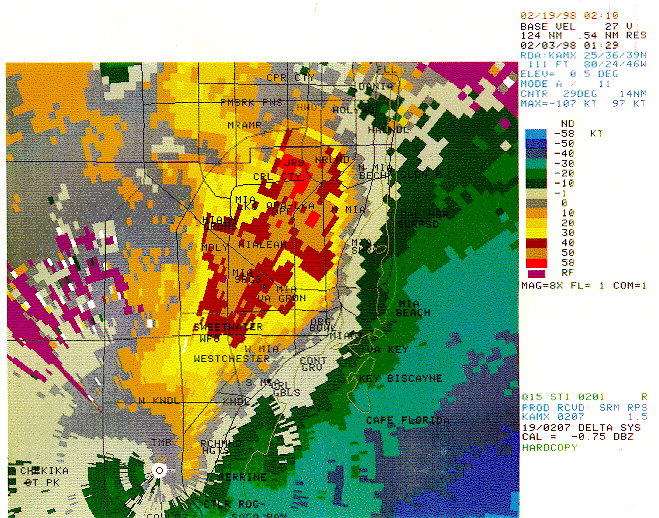
This radar velocity image was taken from the Miami (KAMX) Doppler radarpar at 8:29 pm February 2, 1998 at about the time a tornado was moving north northeastpar through the Hialeah-Opa Locka-Carol City area in north Dade county. The main tornadopar had split into three or four separate vorteces, and the distinctive TVS signature waspar not apparent. Note a well-defined area of winds greater than 58 knots surrounded by anpar extensive area of +50 knot winds.
CURRENT HAZARDS
Submit a Storm Report
Outlooks
Graphical Hazardous Weather Outlook
Self Briefing Page
National Hazards
Tropics / Hurricanes
Local Storm Reports
CURRENT WEATHER
Surface Observations
Satellite
Observed Precipitation
MesoAnalysis
Rivers / Lakes
Latest Sounding
Lake Okeechobee
PAST WEATHER
Recent Rainfall
Tropical Cyclone Reports
Past Events
FORECASTS
Forecast Discussion
Tropical Weather
Probabilistic Page
Heat Page
Cold Weather Page
Marine Weather
Fire Weather
Beach Forecast
Aviation Weather
Probabilistic QPF
Hourly Forecasts
Activity Planner
Graphical Forecast
International Weather
RADAR IMAGERY
National
Miami Radar
Key West Radar
Across Florida
CLIMATE
Local Climate Info
More Local Climate Info
Climate Graphs
US Dept of Commerce
National Oceanic and Atmospheric Administration
National Weather Service
Miami - South Florida
11691 SW 17th Street
Miami, FL 33165
305-229-4522
Comments? Questions? Please Contact Us.

