
Record setting heat is expected over the next several days from the Intermountain West through the northern Plains. Furthermore, fire weather concerns increase with dry and breezy conditions. Meanwhile, heavy rainfall and severe thunderstorm threats for the Ohio/Tennessee Valleys, central Appalachians and Southeast today. The threat shifts to central Gulf Coast and across central Texas this week. Read More >
Miami - South Florida
Weather Forecast Office
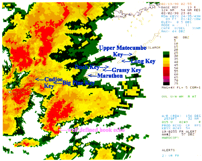
The above radar reflectivity image was taken from the Key West (KBYX) Doppler radar at 6:01 pm February 2, 1998. A well-defined hook echo (radar tornadic signature) is clearly visible over the Florida Straits south of Big Pine Key. Also noteworthy are the large number of strong to severe thunderstorm cells from south of Key West north northeast across the southeast Gulf of America to near the Florida mainland.
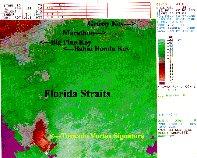
In the velocity image below taken at the same time as the reflectivity image, a TVS (Tornado Vortex Signature) is noted clearly associated with the hook echo observed on the reflectivity image above. The radar identified this thunderstorm cell as "T9", and its value parameters as well as those of another thunderstorm cell, identified as "G6", can be found at the top of the image. "T9" was at an azran (azimuth-range) of 128/26 (128 degrees at 26NM) from the Key West radar. This cell may have been a borderline F3 intensity tornadic waterspout (it weakened some before moving across the Middle Keys and producing moderate damage). Cell "G6", 190/13 from the radar, may have been even stronger but it fortunately passed between Key West and the Marquesas Keys. Miami issued a Tornado Warning for the lower and middle Keys effective from 6:00 pm until 7:05 pm.
CURRENT HAZARDS
Submit a Storm Report
Outlooks
Graphical Hazardous Weather Outlook
Self Briefing Page
National Hazards
Tropics / Hurricanes
Local Storm Reports
CURRENT WEATHER
Surface Observations
Satellite
Observed Precipitation
MesoAnalysis
Rivers / Lakes
Latest Sounding
Lake Okeechobee
PAST WEATHER
Recent Rainfall
Tropical Cyclone Reports
Past Events
FORECASTS
Forecast Discussion
Tropical Weather
Probabilistic Page
Heat Page
Cold Weather Page
Marine Weather
Fire Weather
Beach Forecast
Aviation Weather
Probabilistic QPF
Hourly Forecasts
Activity Planner
Graphical Forecast
International Weather
RADAR IMAGERY
National
Miami Radar
Key West Radar
Across Florida
CLIMATE
Local Climate Info
More Local Climate Info
Climate Graphs
US Dept of Commerce
National Oceanic and Atmospheric Administration
National Weather Service
Miami - South Florida
11691 SW 17th Street
Miami, FL 33165
305-229-4522
Comments? Questions? Please Contact Us.

