|
||||||
1. Origin Tropical Storm Fay developed from a tropical wave which moved across the tropical Atlantic Ocean during the second week of August. The tropical wave began to develop a circulation near the surface east of the Lesser Antilles, but did not become organized enough to be classified as a tropical cyclone until it crossed Puerto Rico and entered Hispaniola on Friday, August 15th. 2. Fay Approaches South Florida High pressure situated east of the Bahamas kept Fay on a general west-northwestward track through much of the weekend of the 16th and 17th. On Sunday, August 17th, the high pressure east of the Bahamas began to weaken as a low pressure area moved into the northeastern Gulf of America. In response to this change in the steering pattern, Fay began to turn gradually to the northwest near the south-central coast of Cuba. At 5 AM on the 17th, the first watches were posted for South Florida. A Hurricane Watch was issued for the northern coast of Florida Bay from the Card Sound Road Bridge westward through Cape Sable, and for the southwest Gulf coast north of Cape Sable to Bonita Beach, including far southern Miami-Dade County, all of Mainland Monroe County and coastal sections of Collier County. A Tropical Storm Watch was issued for the remainder of South Florida including Lake Okeechobee. Fay crossed central Cuba on the 17th, then turned a little more to the north-northwest as it emerged off the north coast of Cuba and into the Straits of Florida during the morning hours of Monday, August 18th. At 5 AM on the 18th, Tropical Storm Warnings were issued for all of South Florida, with a Hurricane Watch remaining in effect for the far south and southwest peninsula coasts. The first outer bands of Fay began to impact southeast Florida during the morning of the 18th, starting across Miami-Dade County and gradually spreading north across the area during the day. Outer bands reached the southwest Florida coast by the early evening of the 18th. The Tropical Storm Warnings were upgraded to Hurricane Warnings from Flamingo to Bonita Beach, including Mainland Monroe County and coastal Collier County at 11 AM on the 18th, with the rest of South Florida remaining under Tropical Storm Warnings. 3. Fay Makes Landfall Fay made its first Florida landfall at Key West shortly before 5 PM on Monday, August 18th. Maximum sustained winds were 60 mph and the minimum pressure was 998 mb. Fay maintained strong tropical storm force strength during the evening and overnight hours as it approached the southwest Gulf coast, although surface pressures continued to fall. Fay made its first peninsular landfall at Cape Romano shortly before 5 AM on Tuesday, August 19th with maximum sustained winds of 60 mph and lowest pressure of 989 mb. Fay turned to the north-northeast while over the western Everglades, with the center passing over Golden Gate Estates and Immokalee during the morning of the 19th. Interestingly enough, the center of Fay became better defined on radar data as it moved over land, a sign that the storm was strengthening despite being over land. The center traversed Hendry County from southwest to northeast, passing between Labelle and Clewiston before passing directly over Moore Haven and Lakeport in Glades County during the afternoon of the 19th. Fay finally exited the WFO Miami area of responsibility around 5 PM on the 19th, just north of Buckhead Ridge. Maximum sustained winds increased to 65 mph and the minimum pressure dropped to 986 mb near Moore Haven, maintaining this intensity over Glades County. 4. South Florida Impacts - Inland Flooding As is typically the case with slow-moving tropical storms, Fay's primary impact was inland flooding. Rainfall amounts ranged from 3-5 inches over Miami-Dade and Broward counties, to 7-10 inches over northern Collier, Hendry and Glades counties near the path of the center of Fay. Isolated areas in northeastern Hendry and southeastern Glades counties received well in excess of 10 inches, with Moore Haven recorded the highest storm total rainfall of 16.17 inches recorded in the 48-hour period ending at 8 AM on Wednesday, August 20th. Portions of eastern Palm Beach County also saw amounts in the 7-9 inch range from an outer band which persisted over that area on the 19th (See Observed Rainfall Map). Extensive flooding was observed over the areas with the highest totals, especially over Hendry and Glades counties. Hardest hit areas were the Felda and Montura areas in Hendry County, and the Muse and Moore Haven areas in Glades counties. Dozens of homes sustained damage from water intrusion, primarily in the Muse community. - Winds The highest winds observed with Fay occurred in a narrow 7 to 8 mile wide band just to the north and east of the center as it crossed over inland sections of southwest Florida. Wind gusts to 65 mph were recorded in Immokalee, and gusts of hurricane force were observed in Moore Haven as the core of the strongest winds passed directly over the city. These winds also impacted the western and northern portions of Lake Okeechobee, with peak sustained winds of 59 mph and peak gust of 79 mph at the western lake tower (South Florida Water Management gauge) at 145 PM and 215 PM, respectively. Most of southeast Florida, including the metro areas of Miami and Fort Lauderdale, saw peak sustained winds just below tropical storm force, with peak gusts of 40-50 mph. The only exception was the immediate coastal areas where sustained winds reached tropical storm force. Portions of northern and eastern Palm Beach County also saw sustained winds of tropical storm force. Wind damage was most noticeable over interior southwest Florida, with some structural damage mainly to mobile homes. Damage was a bit more severe in the Moore Haven area, where a home lost its roof and trapped an elderly man inside. In Pahokee, the city hall sustained wind damage estimated at over $1 million. Over eastern sections, wind damage was mostly confined to downed trees, tree limbs and downed power lines which caused scattered power outages. - Tornadoes North and northeastward-moving tropical cyclones are frequent tornado producers in South Florida. Fay was no exception. Two confirmed tornadoes were reported, a powerful EF2 which did considerable damage in Wellington (Palm Beach County), and a weaker EF0 which produced minor damage in Hallandale Beach (Broward County). An unconfirmed tornado was sighted in Lakeport (Glades County). - Storm Surge/Coastal Flooding Due to Fay remaining at tropical storm strength and the rather limited nature of its wind field, storm surge and coastal flooding impacts were rather minor. The highest storm tide was estimated to be in the Everglades City/Chokoloskee areas, where the maximum storm tide was in the 5 foot range. Water of 1-2 feet deep was observed in Everglades City, and the Chokoloskee Causeway was under water for a short time on the morning of the 19th. Minimal storm surge was noted elsewhere, although moderate to locally severe beach erosion took place at Naples as well as along portions of the central and northern Palm Beach County coastline. |
Click on Images for larger Picture
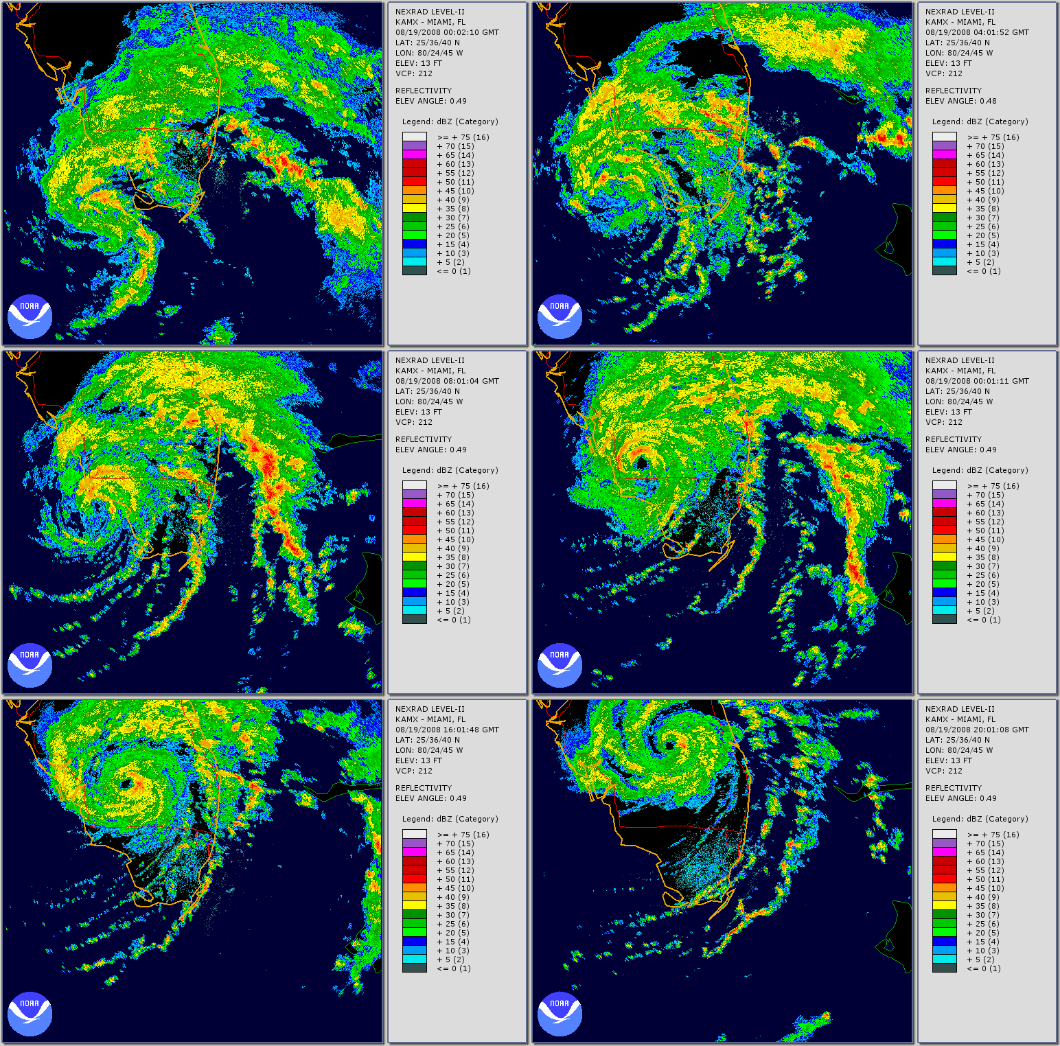
Click for radar loop of Fay as it moved across South Florida.
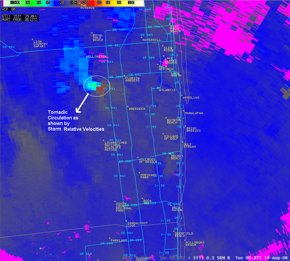
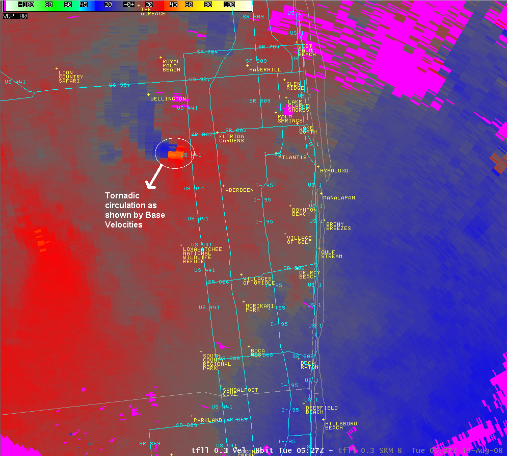
Below: Images of Wellington Tornado Associated with Fay 
Fort Lauderdale Terminal Doppler Radar Storm Relative Velocity valid on Aug 19 2008 at 0527Z (127 AM EDT). See Also Loop (~2 MB).

Fort Lauderdale Terminal Doppler Radar Base Velocity valid on Aug 19 2008 at 0527Z (127 AM EDT). See Also Loop (~2 MB).
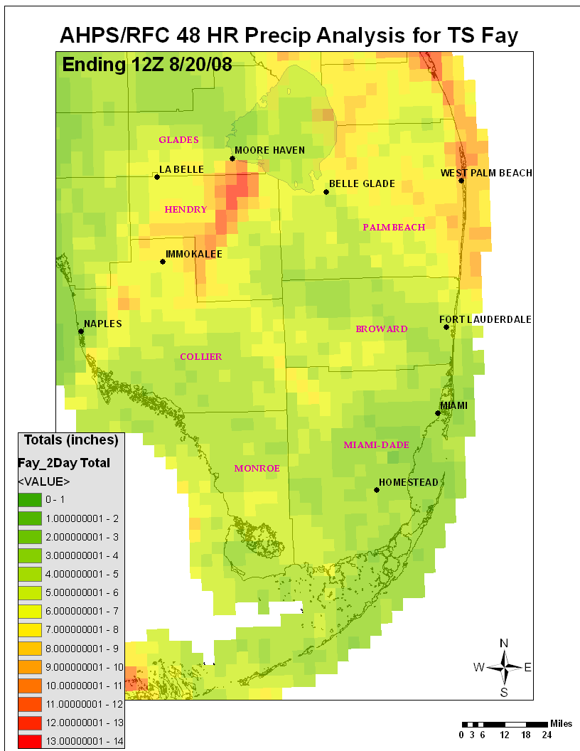
 Tropical Storm Fay observed rainfall amounts across South Florida from 8 AM Monday Aug 18 to 8 AM Wednesday Aug 20 2008. Units are in inches. |
|||||