Miami - South Florida
Weather Forecast Office
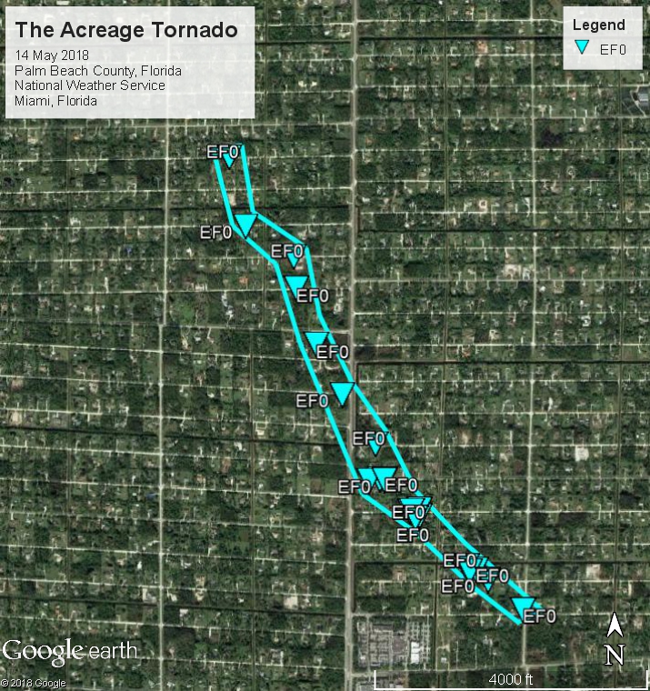
NWS DAMAGE SURVEY FOR 05/14/2018 PALM BEACH COUNTY TORNADO EVENT

.OVERVIEW...
A severe thunderstorm along a band of convection spawned a brief
tornado over The Acreage in Palm Beach County early Monday
morning.

.THE ACREAGE TORNADO...

Rating:                 EF-0
Estimated peak wind:    75-80 mph
Path length (statute):  1.5 miles
Path width (maximum):   50 yards
Fatalities:             0
Injuries:               0

Start date:             05/14/2018
Start time:             0534 AM EDT
Start location:         2 WNW The Acreage, Palm Beach County, FL
Start lat/lon:          26.7823 / -80.2867

End date:               05/14/2018
End time:               0538 AM EDT
End location:           4 NW The Acreage, Palm Beach County, FL
End_lat/lon:            26.8010 / -80.2997

EF scale: The Enhanced Fujita scale classifies
tornadoes into the following categories.

EF0...weak......65 to 85 mph
EF1...weak......86 to 110 mph
EF2...strong....111 to 135 mph
EF3...strong....136 to 165 mph
EF4...violent...166 to 200 mph
EF5...violent...>200 mph

Note:
The information in this statement is preliminary and subject to
change pending final review of the event and publication in
NWS Storm Data.

Damage Path files: KML | Shapefile
CURRENT HAZARDS
Submit a Storm Report
Outlooks
Graphical Hazardous Weather Outlook
Self Briefing Page
National Hazards
Tropics / Hurricanes
Local Storm Reports
CURRENT WEATHER
Surface Observations
Satellite
Observed Precipitation
MesoAnalysis
Rivers / Lakes
Latest Sounding
Lake Okeechobee
PAST WEATHER
Recent Rainfall
Tropical Cyclone Reports
Past Events
FORECASTS
Forecast Discussion
Tropical Weather
Probabilistic Page
Heat Page
Cold Weather Page
Marine Weather
Fire Weather
Beach Forecast
Aviation Weather
Probabilistic QPF
Hourly Forecasts
Activity Planner
Graphical Forecast
International Weather
RADAR IMAGERY
National
Miami Radar
Key West Radar
Across Florida
CLIMATE
Local Climate Info
More Local Climate Info
Climate Graphs
US Dept of Commerce
National Oceanic and Atmospheric Administration
National Weather Service
Miami - South Florida
11691 SW 17th Street
Miami, FL 33165
305-229-4522
Comments? Questions? Please Contact Us.

