|
April 3rd 2012 Severe Weather Outbreak
Rockwall/Hunt County Tornado
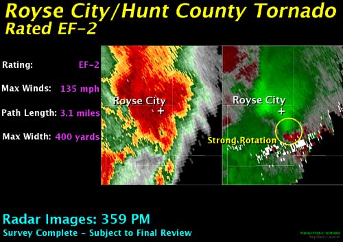
Meteorologists from the National Weather Service in Fort Worth have given portions of the damage near Royse City a preliminary rating of EF-2, with estimated wind speeds up to 135 mph. The tornado had a path length of 3.1 miles and a maximum width of 400 yards. Additional information will be added to this page as it becomes available.
|
...Preliminary findings from the Kaufman, Rockwall and Hunt County surveys...
On Wednesday, April 4, 2012, a crew from the National Weather Service in Fort Worth surveyed the damaged areas in the Forney and Royse City areas in Kaufman, Rockwall, and Hunt Counties.
The findings were that two tornadoes affected the area.
The first tornado remained in Kaufman County throughout its time on the ground and initially touched down near Forney southwest of Highway 80. This tornado produced damage consistent with an EF-3 on the Enhanced Fujita Scale. The maximum path width was about 150 yards with an estimated path length of 8 miles. The maximum wind speeds are estimated to have been at 150 mph. The most intense damage associated with this tornado occurred in the Diamond Creek subdivision northeast of Forney. Two homes were completely destroyed in this subdivision and several others were heavily damaged. As the tornado moved north-northeast through the subdivision it produced damage primarily to the roof of Crosby Elementary school.
There were also several vehicles damaged in the schools parking lot, one of which was lofted approximately 300 yards away from the school and found in a field to the northeast. No fatalities or serious injuries were reported with this tornado.
|

|
|
The second tornado touched down just southwest of Farm to Market road 548 near Bent Road in Rockwall County. This tornado moved northeast into Hunt County and lifted north of Highway 276 just across the Hunt County line. This tornado produced damage consistent with a strong EF-2 on the Enhanced Fujita Scale. The maximum path width was about 400 yards with an estimated path length of 3.1 miles. Damage associated with this tornado began in the subdivision near the intersection of Farm to Market Road 548 and Bent Road. One home was mostly destroyed within the subdivision and several others sustained heavy damage. The tornado continued its path to the northeast, damaging several homes along country manor road. The tornado continued its northeastward path through Rockwall County crossing State Highway 276 towards Hunt County. As it moved into Hunt County, it destroyed two mobile homes and damaged two others. The tornado caused heavy damage to another home in Hunt County before lifting.
|
|

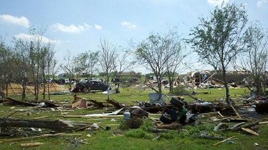
A picture of the scope of tornado damage south of Royse City in Rockwall County.
This damage has been rated as a high end EF-2, likely caused by tornado wind
speeds of 130 to 135 mph.
|
|