
Tropical Depression Two is expected to gradually strengthen and could bring tropical storm conditions to the Florida Panhandle beginning late Monday. Areas of flash flooding will be possible through Thursday along the eastern and central Gulf Coast. Severe thunderstorms will develop and move along a cold front crossing the Upper Midwest Monday, and through the Ohio Valley/Mid-Atlantic on Tuesday. Read More >
Denver/Boulder, CO
Weather Forecast Office
Overview
|
The fast moving weather disturbance Monday night into early Tuesday morning produced significant snowfall across most of the Front Range foothills. Much lighter amounts fell in the I-25 Urban Corridor, with no snow over the northeastern Colorado plains. The latest snowfall map can be found below. NWS Boulder sends a big thanks to all the Weather Spotters, COOP observers, CoCoRaHS observers, and public for all your reports! More local storm reports can be found here. |
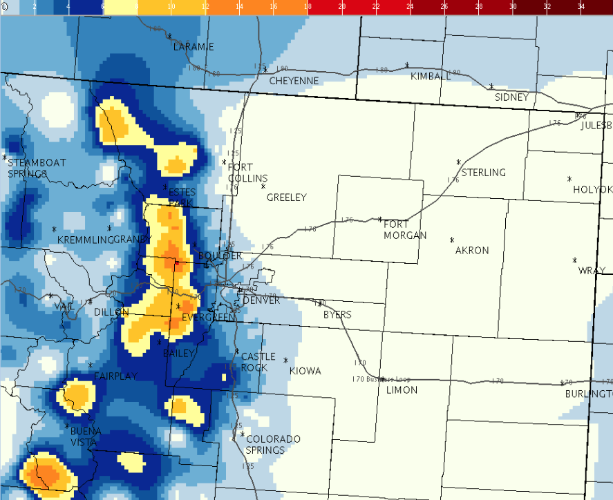 February 23 Snow StormTotal Map |
Snow/Ice Totals (Inches)
3 WNW Pinecliffe 15 inches
4 NE Nederland 15 inches
5 NE Ward 14.6 inches
3 SE Pinecliffe 12 inches
Genesee 12 inches
1 S Evergreen 11 inches
1 SSE Bergen Park 10.7 inches
1 NNW Evergreen 10.7 inches
4 SSE Brookvale 9 inches
11 SSW Georgetown 8.8 inches
4 NE Ward 8.1 inches
 |
Media use of NWS Web News Stories is encouraged! Please acknowledge the NWS as the source of any news information accessed from this site. |
|
US Dept of Commerce
National Oceanic and Atmospheric Administration
National Weather Service
Denver/Boulder, CO
325 Broadway
Boulder, CO 80305-3328
303-494-3210 for a recording call 303-494-4221
Comments? Questions? Please Contact Us.

