Gusty to high winds and low relative humidity will bring elevated to critical fire weather to the central and southern Plains into Wednesday. Two Pacific storms will impact the western U.S. into Wednesday with gusty winds, low elevation rain, and heavy mountain snow. Read More >
 |
 |
 |
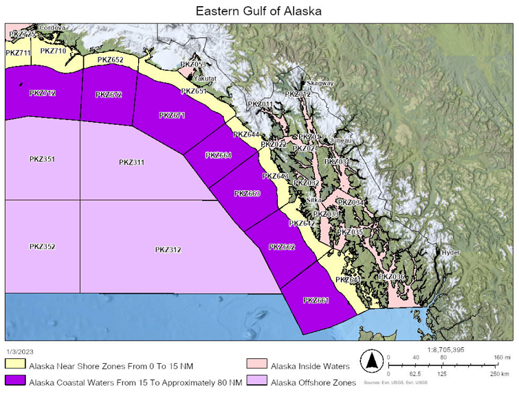
The National Weather Service's mission to protect life and property and to enhance the national economy includes a suite of products for the water bodies adjacent to the U.S. The marine forecasting program is aimed at promoting safe and efficient transportation, both commercial and recreational. NWS national centers or WFOs issue several marine products:
 |
NWS forecasters need frequent, high-quality marine observations to examine conditions for forecast preparation and to verify their forecasts after they are produced. These observations are especially critical to the output of numerical weather models because large water bodies have a profound impact on the weather. Other users rely on the observations and forecasts for commercial and recreational activities. To help meet these needs, the NWS's National Data Buoy Center (NDBC) operates a network of 110 buoys and 51 land-based coastal observing systems (C-MAN). All stations measure wind speed, direction, and gust; barometric pressure; and air temperature. In addition, all buoy stations and some C-MAN stations measure sea surface temperature, wave height and period. Conductivity and water current are measured at selected stations. All stations report hourly.
Supplemental weather observations are acquired through the United States Voluntary Observing Ship (VOS) program. It is organized for the purpose of obtaining weather and oceanographic observations from transiting ships. An international program under World Meteorological Organization (WMO) marine auspices, the VOS has forty-nine countries as participants. The United States program is the largest in the world, with nearly 1,000 vessels. Observations are taken by deck officers, coded in a special format known as the "ships synoptic code", and transmitted in realtime to the NWS. They are then distributed on national and international circuits for use by meteorologists in weather forecasting, by oceanographers, ship routing services, fishermen, and many others.
 |
Welcome to WFO Juneau | NWS History | Operations | Forecast Products | Local Area Information |  |
| Marine Forecast | Fire Weather | Hydrology | Satellites |