
Record setting heat is expected over the next several days from the Intermountain West through the northern Plains. Furthermore, fire weather concerns increase with dry and breezy conditions. Meanwhile, heavy rainfall and severe thunderstorm threats for the Ohio/Tennessee Valleys, central Appalachians and Southeast today. The threat shifts to central Gulf Coast and across central Texas this week. Read More >
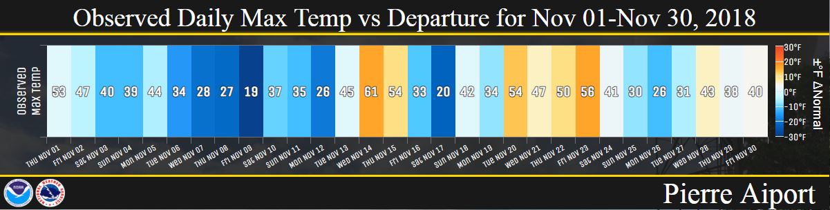
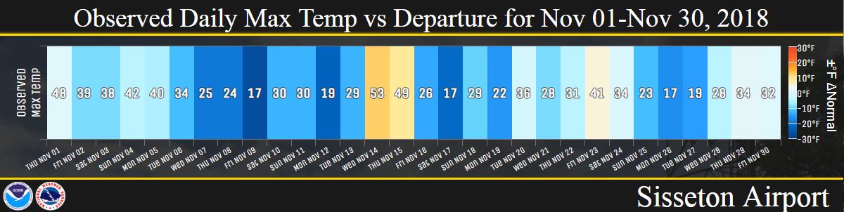
November 2018 changed little from the month before, as in temperatures remained relatively chilly on a whole. The area ranged from 2 to 8 degrees below average, with northeastern South Dakota and western Minnesota being the coolest. Sisseton recorded their 6th coldest November on record, and Wheaton tied for their 5th coldest. Aberdeen, Watertown, Sisseton and Pierre recorded either record cold lows or highs on November 9th, and additional cold records were set on the 17th and 10th across the area.
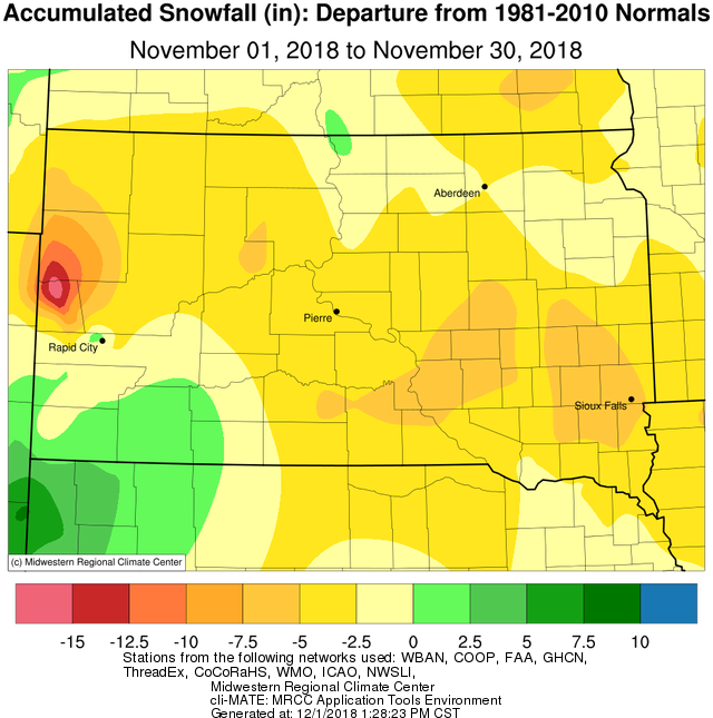
No blockbuster winter storms impacted the area this November (historically, November is one of our snowiest months), but there were a number of wintry precipitation events that led to difficult travel. Namely, a swath of generally 2-6 inches (locally higher) of snow impacted north central and northeastern South Dakota and west central Minnesota on the 16th. Additionally, light freezing rain impacted the area on the 28th and freezing drizzle impacted mainly central South Dakota on the evening of the 16th.
|
November 2018 |
||||
|
Temperature Data |
Aberdeen |
Sisseton |
Wheaton |
Watertown |
|
Warmest Temperature / Date |
56°/ 14th |
53°/ 14th |
51°/ 14th |
53°/ 14th, 1st |
|
Coldest Temperature / Date |
-6°/ 17th |
-3°/ 19th |
-1°/ 20th |
-6°/ 17th |
|
Average High / Departure from Normal |
33.6°/ -6.0° |
31.1°/ -9.1° |
31.3°/ -7.3° |
32.2°/ -6.8° |
|
Average Low / Departure from Normal |
15.9°/ -3.0° |
16.1°/ -5.4° |
16.9°/ -3.5° |
16.0°/ -4.6° |
|
Monthly Average / Departure from Normal |
24.8°/ -4.5° |
23.6°/ -7.2° |
24.1°/ -5.4° |
24.1°/ -5.7° |
|
Precipitation Data |
||||
|
Monthly Precipitation / Departure from Normal |
0.90”/+0.17” |
1.15”/+0.57” |
0.94”/ -0.19” |
0.85”/+0.09” |
|
Most Precipitation in 24 hours / Date |
0.34”/ 5th |
0.40”/ 5th |
0.42”/ 5th |
0.45”/ 5th |
|
Monthly Snowfall / Departure from Normal |
4.6” / -2.4” |
3.9” / -3.4” |
2.4” / -2.2” |
4.9” / +0.0” |
|
Most Snow in 24 hours / Date |
3.6” / 16th |
2.1” / 16th |
0.9” / 16th |
4.0” / 16th |
|
Temperature Data |
Pierre |
Kennebec |
Mobridge |
Timber Lake |
|
Warmest Temperature / Date |
61°/ 14th |
70°/ 22nd |
63°/ 14th |
59°/ 14th |
|
Coldest Temperature / Date |
7°/ 9th |
5°/ 9th |
9°/ 17th |
1°/ 8th |
|
Average High / Departure from Normal |
39.1°/ -5.0° |
42.5°/ -3.0° |
37.0°/ -5.8° |
37.1°/ -4.8° |
|
Average Low / Departure from Normal |
22.5°/ -0.8° |
22.2°/ -0.4° |
22.7°/ +1.6° |
19.5°/ -1.7° |
|
Monthly Average / Departure from Normal |
30.8°/ -2.9° |
32.4°/ -1.6° |
29.8°/ -2.1° |
28.3°/ -3.3° |
|
Precipitation Data |
||||
|
Monthly Precipitation / Departure from Normal |
0.52”/ -0.24” |
0.72”/+0.0” |
0.67”/+0.19” |
0.71”/ +0.10” |
|
Most Precipitation in 24 hours / Date |
0.17”/ 3rd |
0.37” / 3rd |
0.29”/ 16th |
0.25”/ 3rd |
|
Monthly Snowfall / Departure from Normal |
2.5” / -2.8” |
3.2” / -3.1” |
3.4” / -1.3” |
0.8” / -5.1” |
|
Most Snow in 24 hours / Date |
2.0” / 8th |
2.4” / 9th |
2.8” / 16th |
0.2” / 9th, 16th |
Temperature departures from an average November, from the Midwestern Regional Climate Center

Observed daily maximum temperatures (values) and departures (color) throughout November for Aberdeen, Watertown, Pierre, Sisseton and Mobridge


Total snowfall in November, from the Midwestern Regional Climate Center

Total snowfall departures in November, from the Midwestern Regional Climate Center
Total precipitation departures in November, from the Midwestern Regional Climate Center

December is the first month of meteorological winter - here's a look ahead at what's typically to come.
For the latest temperature and precipitation outlooks, visit the Climate Prediction Center.


