
Tropical Depression Two is expected to gradually strengthen and could bring tropical storm conditions to the Florida Panhandle beginning late Monday. Areas of flash flooding will be possible through Thursday along the eastern and central Gulf Coast. Severe thunderstorms will develop and move along a cold front crossing the Upper Midwest Monday, and through the Ohio Valley/Mid-Atlantic on Tuesday. Read More >
Overview
|
Widespread strong to significantly severe storms impacted central and northeastern South Dakota, mainly from the evening into the night on Monday, June 20th, 2022. While isolated storms tracked across portions of north central South Dakota during the afternoon, a bowing line of thunderstorms with a history of 60 to 85 mph straight-line wind gusts entered Jones County around 6:40pm. This storm would continue to the northeast, reaching the Aberdeen area by around 9:40pm, while continuing to produce 60 to 80+ mph wind gusts. Among the hardest hit was Pierre, where numerous trees were damaged, along with other property. Additional strong to severe thunderstorms then developed and tracked through and east of the Prairie Coteau from roughly 9:45 to 11:15pm with wind gusts of 60 to 70+ mph. Additional damage was reported with these storms. While hail was a lesser threat, golf ball-sized stones did fall in Hand County. |
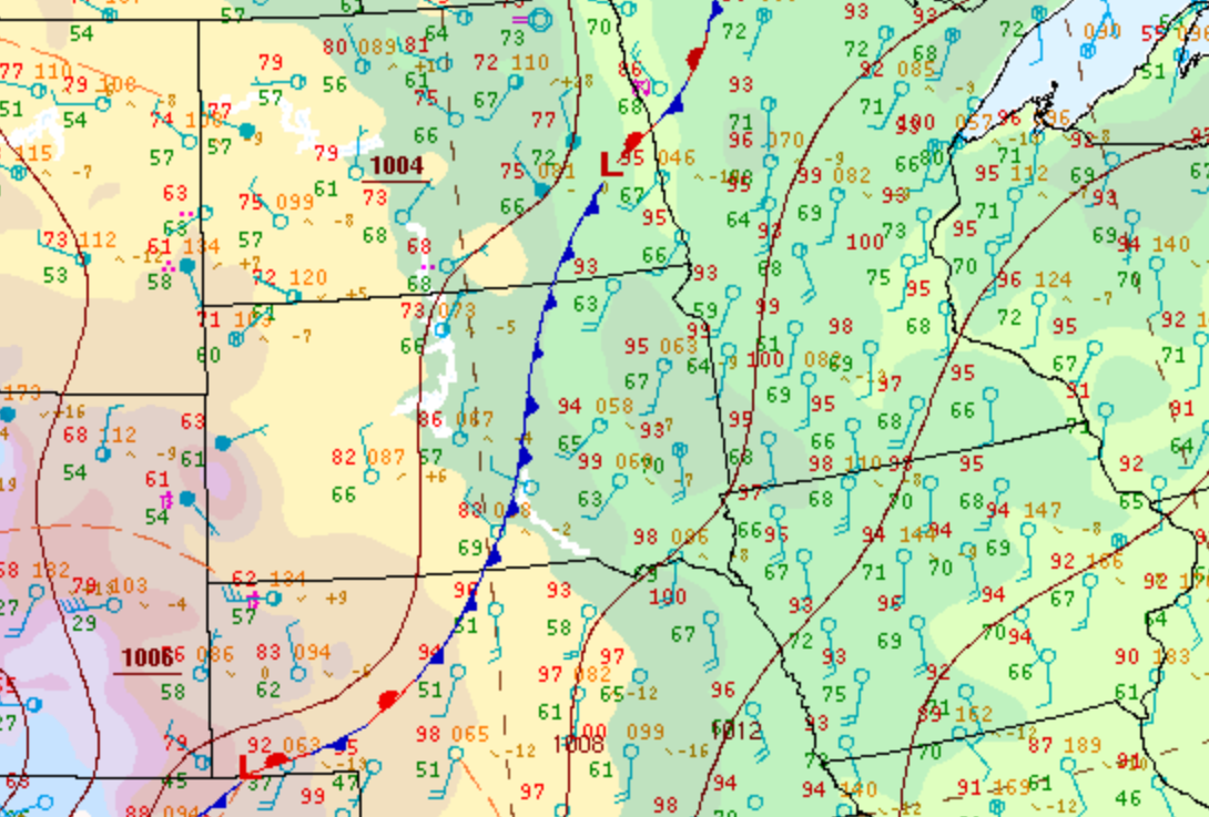 Surface weather map at 4pm June 20th, prior to the beginning of more widespread severe thunderstorm activity, showing a cold front draped across central SD with hot and humid conditions to the east and somewhat cooler but still humid conditions to the west of it. |
Photos & Video
 |
 |
 |
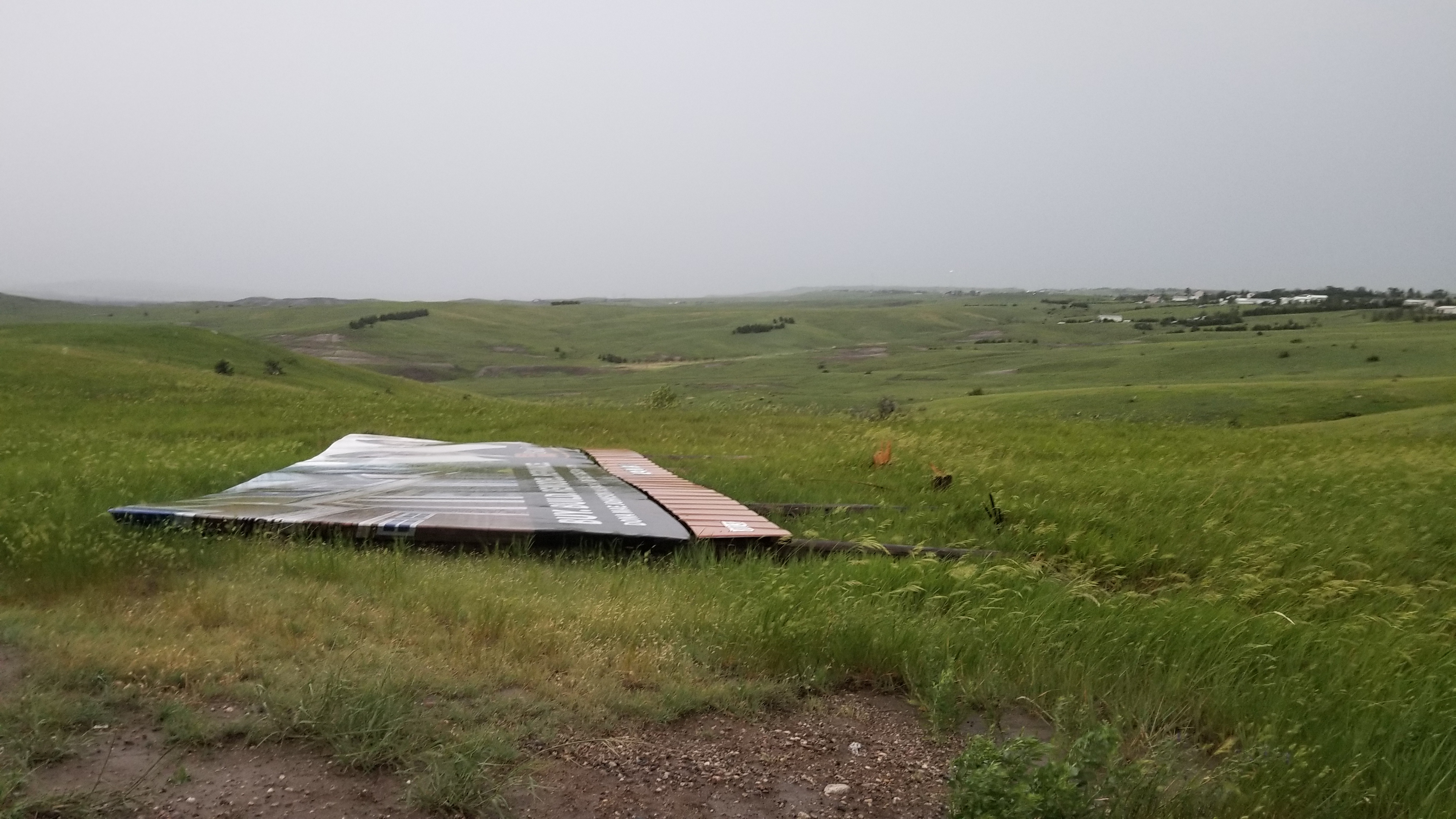 |
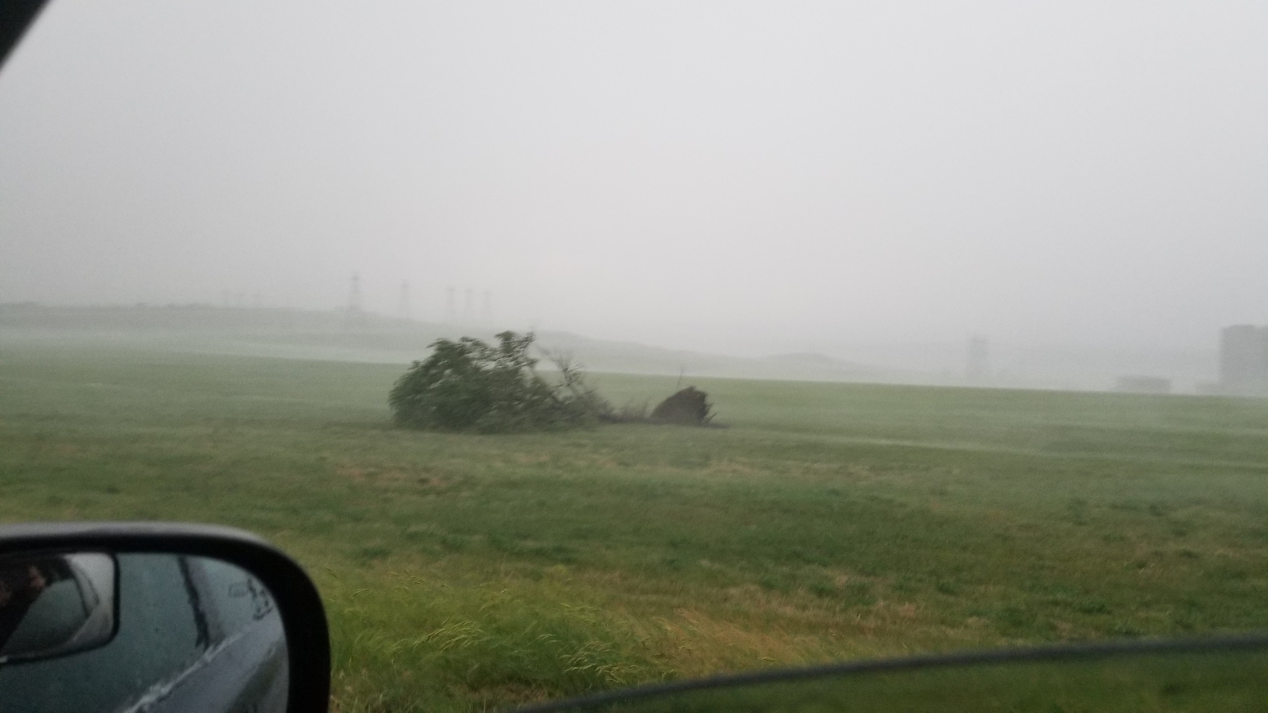
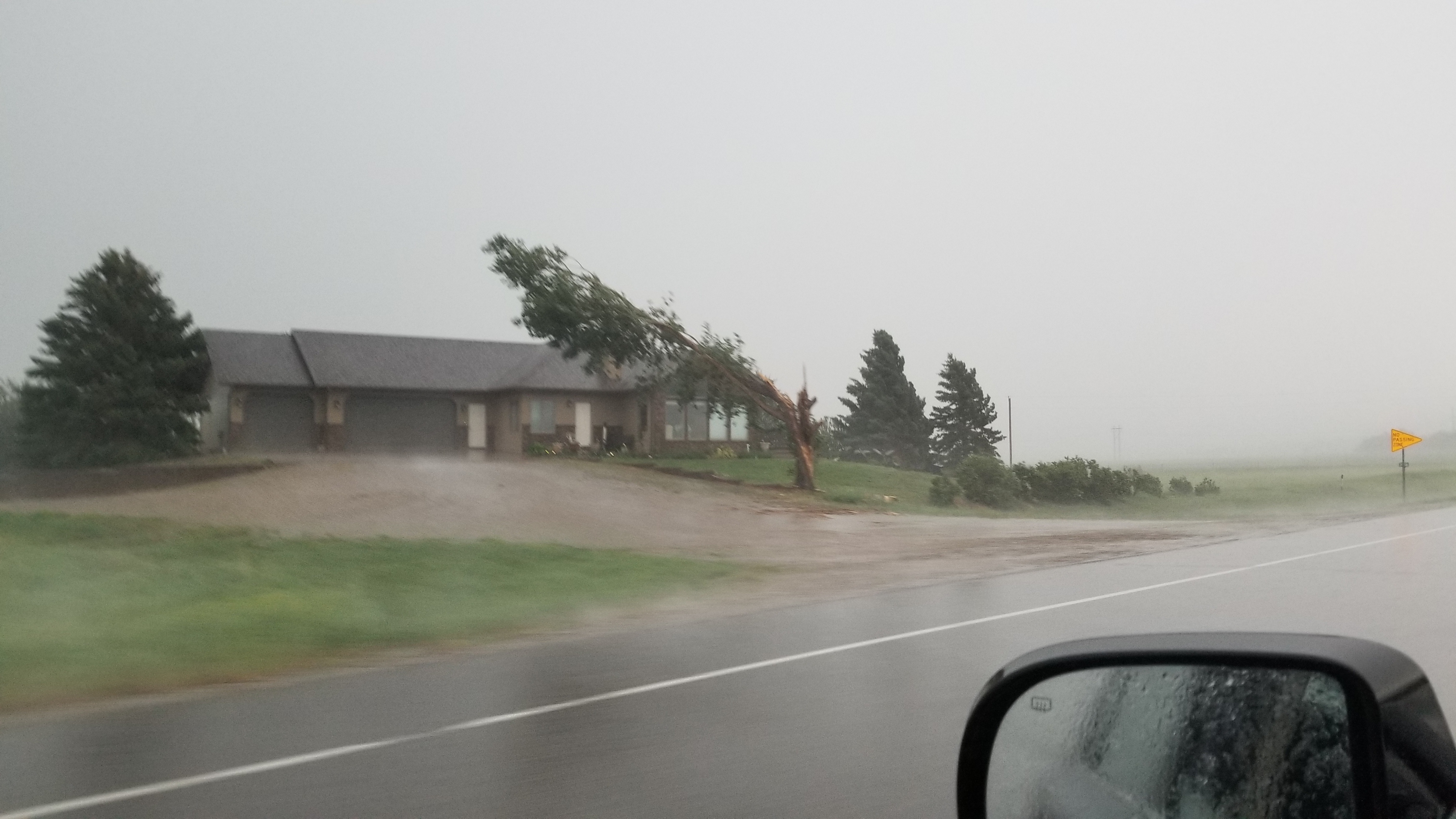
| Shelf cloud as viewed near the Oahe Dam, northwest of Pierre. Photo from an NWS employee. | Tree uprooted near the Oahe Dam, northwest of Pierre. Photo from an NWS employee. | Tree damage near the Oahe Dam, northwest of Pierre. Photo from an NWS employee. | Billboard blown down on the north side of Pierre. Photo from an NWS employee. |
 |
 |
 |
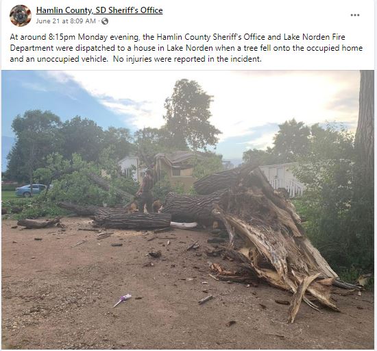 |
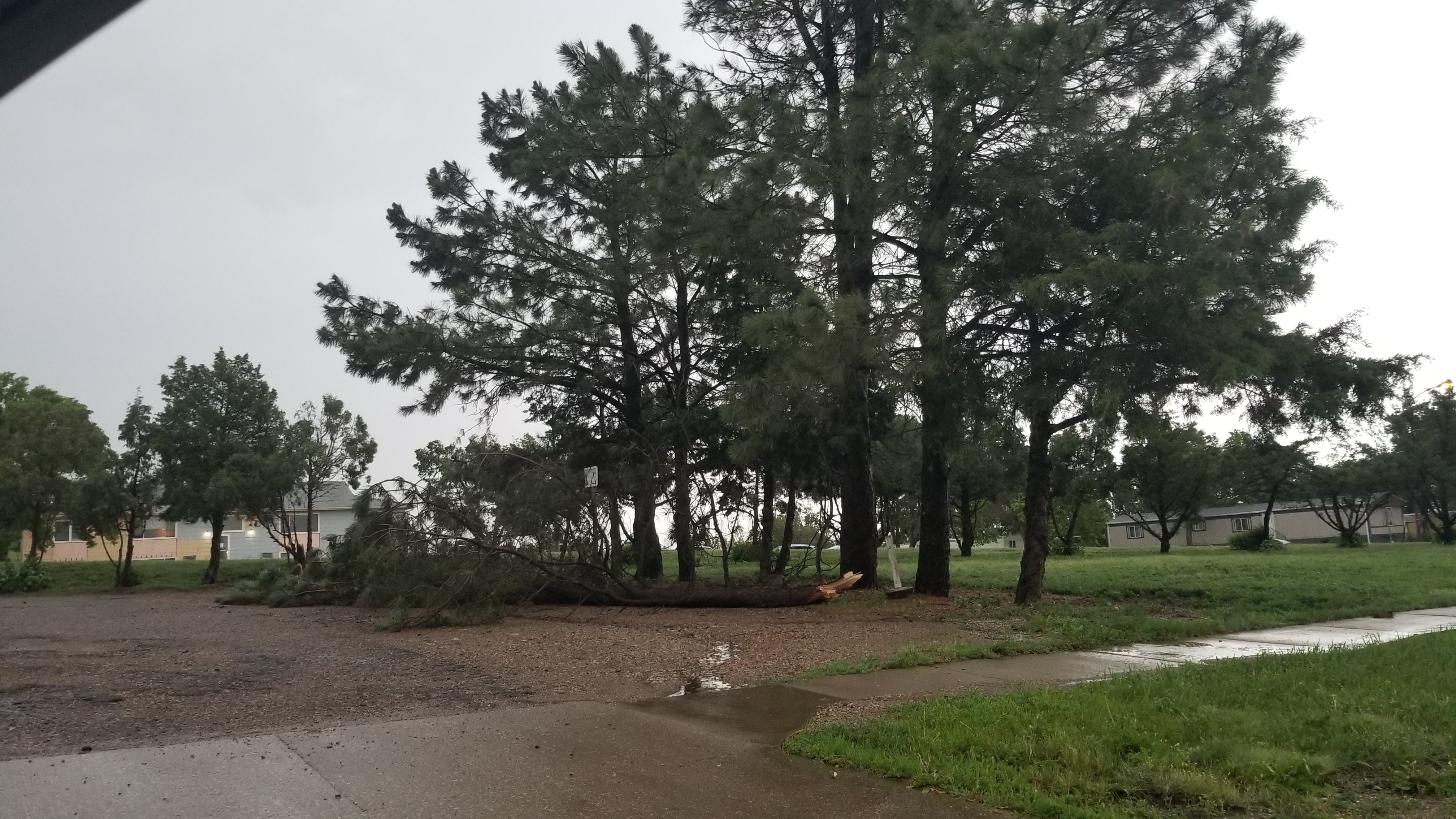
| Tree damage in Pierre. Photo from an NWS employee. | Tree damage in Pierre. Photo from an NWS employee. | Tree damage in the Blunt area. Photo courtesy of the Blunt Rural Fire Department. | Downed tree in Lake Norden, as reported by the Hamlin County Sheriff's Office. |
 |
 |
||
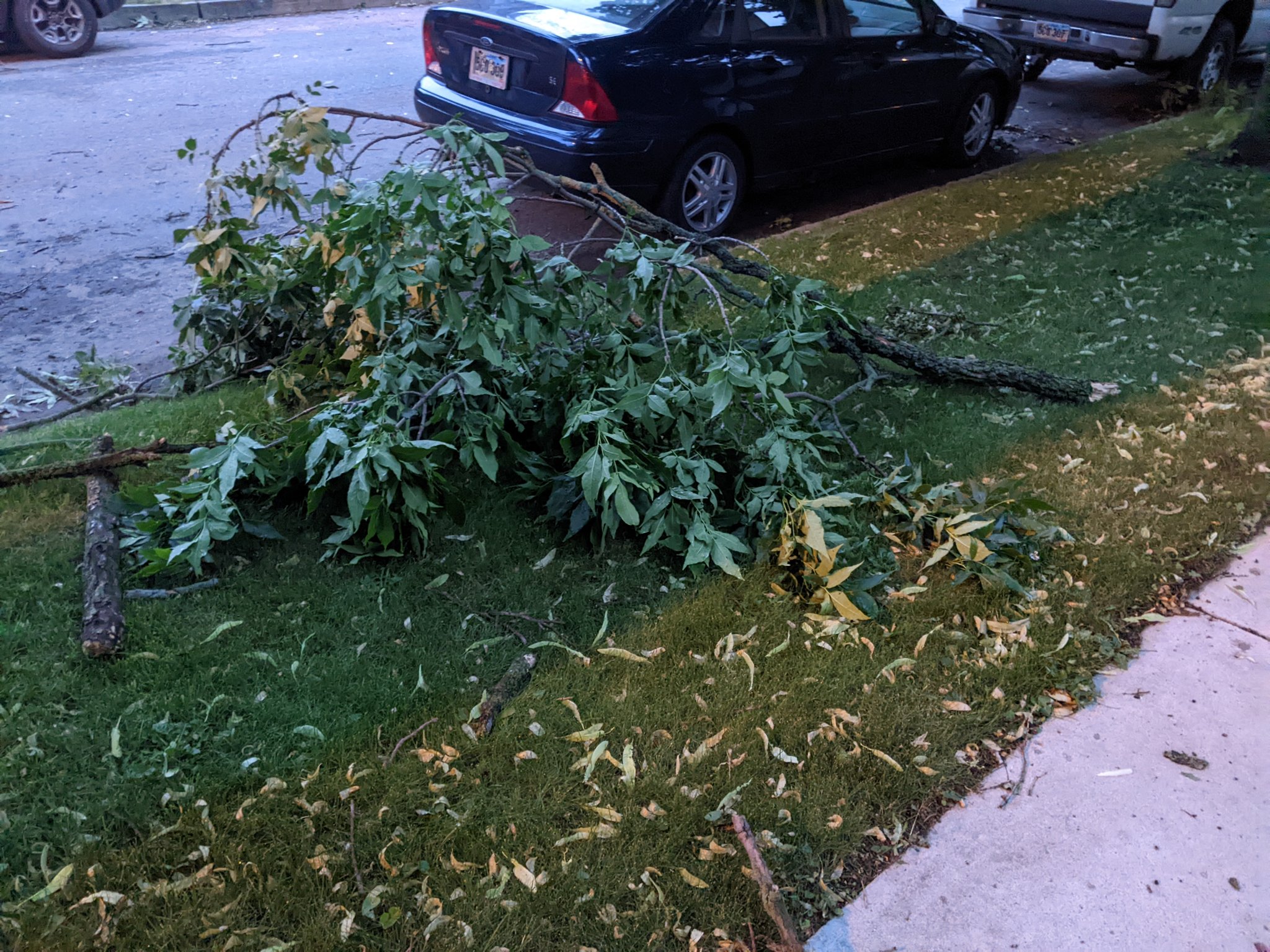
| One of many tree branches down throughout Watertown. Photo courtesy of Brent Nathaniel. | Rainbow as seen on the outskirts of Pierre. Photo from an NWS employee. |
Radar
 |
|
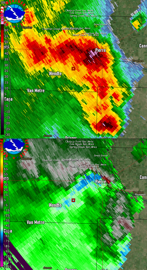
| Radar reflectivity overview of severe weather on June 20th, 2022 | Radar reflectivity (top) and velocity (bottom) at 728pm, 6-20-2022, showing significantly severe winds in and around Pierre, SD |
Storm Reports
Below is an overview of preliminary reports of severe weather. Find an interactive map that details each report here.
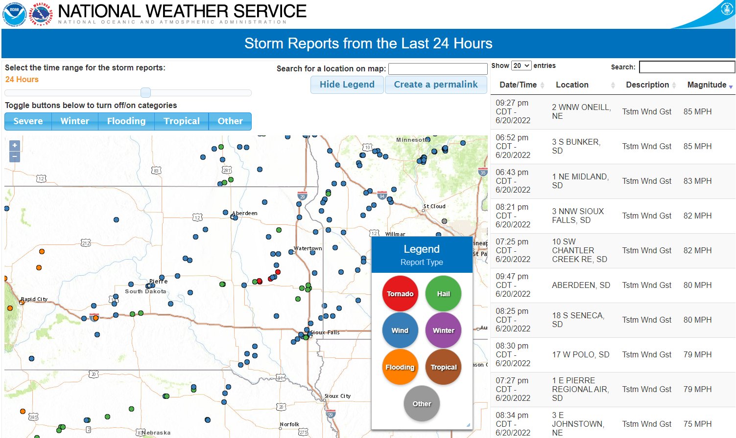
Alternatively, find a listing of preliminary reports below.
PRELIMINARY LOCAL STORM REPORT...SUMMARY
NATIONAL WEATHER SERVICE ABERDEEN SD
1250 PM CDT TUE JUN 21 2022

..TIME...   ...EVENT...      ...CITY LOCATION...     ...LAT.LON...
..DATE...   ....MAG....      ..COUNTY LOCATION..ST.. ...SOURCE....
            ..REMARKS..

0550 PM     TSTM WND GST     7 SSW CHARLESVILLE      45.86N 96.34W
06/20/2022  E50 MPH          TRAVERSE           MN   PUBLIC
            HEAVY RAIN.

0550 PM     HAIL             8 E WHEATON             45.83N 96.34W
06/20/2022  E0.88 INCH       TRAVERSE           MN   PUBLIC
            NICKEL HAIL, NO WIND.

0652 PM     TSTM WND GST     3 S BUNKER              44.20N 101.10W
06/20/2022  M85 MPH          STANLEY            SD   MESONET
            PERSONAL WEATHER STATION.

0707 PM     HAIL             2 NNW MURDO             43.91N 100.73W
06/20/2022  U0.50 INCH       JONES              SD   PUBLIC
            REPORT FROM MPING: HALF-INCH (0.50 IN.).

0713 PM     HAIL             DRAPER                  43.93N 100.54W
06/20/2022  E0.70 INCH       JONES              SD   PUBLIC

0721 PM     TSTM WND GST     10 SW CHANTLER CREEK RE 44.39N 100.77W
06/20/2022  M71 MPH          STANLEY            SD   MESONET
            MESONET STATION 202 HAYES (SDDOT).

0725 PM     TSTM WND GST     10 SW CHANTLER CREEK RE 44.39N 100.77W
06/20/2022  M82 MPH          STANLEY            SD   MESONET
            MESONET STATION 202 HAYES (SDDOT).

0727 PM     TSTM WND GST     1 E PIERRE REGIONAL AIR 44.38N 100.28W
06/20/2022  M79 MPH          HUGHES             SD   ASOS
            ADDITIONAL COMMENTS ADDED: POWERLINES DOWN,
            ROOF DAMAGE AND TREES DOWN IN PIERRE AREA.

0730 PM     TSTM WND GST     1 SW TIMBER LAKE        45.42N 101.09W
06/20/2022  M58 MPH          DEWEY              SD   MESONET

0732 PM     TSTM WND GST     FORT PIERRE             44.36N 100.38W
06/20/2022  M72 MPH          STANLEY            SD   MESONET

0733 PM     TSTM WND GST     PIERRE                  44.37N 100.35W
06/20/2022  M61 MPH          HUGHES             SD   MESONET

0745 PM     TSTM WND GST     6 SW JOE CREEK REC AREA 44.08N 99.87W
06/20/2022  M58 MPH          LYMAN              SD   MESONET
            MESONET STATION 285 14W LOWER BRULE (SDDOT).

0749 PM     TSTM WND GST     4 WSW BLUNT             44.50N 100.07W
06/20/2022  M72 MPH          HUGHES             SD   MESONET
            MESONET STATION 185 BLUNT (SDDOT).

0801 PM     TSTM WND GST     1 ENE HARROLD           44.53N 99.72W
06/20/2022  M61 MPH          HUGHES             SD   MESONET
            MESONET STATION 19 HARROLD (SDDOT).

0808 PM     TSTM WND GST     1 NE STEPHAN            44.26N 99.44W
06/20/2022  M59 MPH          HYDE               SD   MESONET
            MESONET STATION 183 MACS CORNER (SDDOT).

0825 PM     TSTM WND GST     18 S SENECA             44.81N 99.55W
06/20/2022  E80 MPH          HYDE               SD   PUBLIC
            RELAYED BY EMERGENCY MANAGER.

0830 PM     TSTM WND GST     17 W POLO               44.78N 99.45W
06/20/2022  M79 MPH          HYDE               SD   MESONET
            MESONET STATION 215 JCT SD47/SD26 (SDDOT).

0830 PM     TSTM WND DMG     TORONTO                 44.57N 96.64W
06/20/2022                   DEUEL              SD   EMERGENCY MNGR
            SEVERAL 2 TO 4 INCH BRANCHES DOWN IN TOWN.
            TIME ESTIMATED ON RADAR.

0840 PM     HAIL             8 SSE VAYLAND           44.39N 98.72W
06/20/2022  E1.75 INCH       HAND               SD   TRAINED SPOTTER

0900 PM     TSTM WND GST     2 N BRENTWOOD COLONY    45.15N 99.31W
06/20/2022  E67 MPH          FAULK              SD   MESONET
            PERSONAL WEATHER STATION.

0900 PM     TSTM WND GST     8 NE NORBECK            45.27N 99.09W
06/20/2022  M63 MPH          EDMUNDS            SD   MESONET

0931 PM     TSTM WND GST     ABERDEEN REGIONAL AIRPO 45.45N 98.42W
06/20/2022  M67 MPH          BROWN              SD   ASOS

0933 PM     TSTM WND GST     1 W RICHMOND LAKE REC A 45.54N 98.64W
06/20/2022  E70 MPH          BROWN              SD   NWS EMPLOYEE

0946 PM     TSTM WND GST     2 S LILY                45.15N 97.68W
06/20/2022  M62 MPH          DAY                SD   PUBLIC

0947 PM     TSTM WND GST     ABERDEEN                45.47N 98.48W
06/20/2022  E80 MPH          BROWN              SD   TRAINED SPOTTER

0950 PM     TSTM WND GST     VIENNA                  44.70N 97.50W
06/20/2022  E60 MPH          CLARK              SD   TRAINED SPOTTER

0953 PM     TSTM WND GST     6 W HENRY               44.88N 97.58W
06/20/2022  M64 MPH          CLARK              SD   MESONET

0958 PM     TORNADO          BRYANT                  44.59N 97.47W
06/20/2022                   HAMLIN             SD   STORM CHASER

1000 PM     HAIL             7 SSE WEBSTER           45.26N 97.45W
06/20/2022  M1.00 INCH       DAY                SD   TRAINED SPOTTER

1007 PM     TSTM WND GST     7 S BRITTON             45.70N 97.77W
06/20/2022  E50 MPH          MARSHALL           SD   TRAINED SPOTTER

1012 PM     TSTM WND GST     WATERTOWN AIRPORT       44.91N 97.17W
06/20/2022  M67 MPH          CODINGTON          SD   ASOS

1012 PM     TSTM WND DMG     HENRY                   44.88N 97.46W
06/20/2022                   CODINGTON          SD   PUBLIC
            1 INCH DIAMETER TREE BRANCHES DOWN.

1024 PM     TSTM WND GST     1 NW TUNERVILLE         44.90N 96.69W
06/20/2022  M60 MPH          DEUEL              SD   MESONET

1027 PM     TSTM WND GST     6 SSW PEEVER            45.46N 96.99W
06/20/2022  M65 MPH          ROBERTS            SD   MESONET

1027 PM     TSTM WND GST     SISSETON MUNICIPAL AIRP 45.67N 97.00W
06/20/2022  M58 MPH          ROBERTS            SD   ASOS

1035 PM     TSTM WND DMG     1 NE MILBANK            45.23N 96.62W
06/20/2022                   GRANT              SD   EMERGENCY MNGR
            MANY TREES SNAPPED AND UPROOTED AT THE
            CEMETERY NORTHEAST OF MILBANK. ALSO ONE
            TWO-STALL SHED DESTROYED AND ANOTHER
            OUTBUILDING WITH ROOF DAMAGE.

1042 PM     TSTM WND GST     1 W ODESSA              45.26N 96.34W
06/20/2022  M71 MPH          BIG STONE          MN   MESONET
            TIME ESTIMATED BASE ON RADAR.

1050 PM     TSTM WND DMG     3 SW DUMONT             45.69N 96.46W
06/20/2022                   TRAVERSE           MN   PUBLIC
            BRANCHES DOWN, ONE TREE SNAPPED, A COUPLE
            POLES SNAPPED HOLDING A 9 INCH ELK FENCE.
            ESTIMATED WINDS AROUND 60MPH.

1050 PM     TSTM WND GST     3 WSW GRACEVILLE        45.56N 96.49W
06/20/2022  M71 MPH          BIG STONE          MN   MESONET

1052 PM     TSTM WND GST     7 ESE CLINTON           45.42N 96.31W
06/20/2022  M58 MPH          BIG STONE          MN   MESONET

1054 PM     TSTM WND GST     1 NNW DUMONT            45.73N 96.43W
06/20/2022  M67 MPH          TRAVERSE           MN   MESONET

1104 PM     TSTM WND GST     2 NNE DUMONT            45.74N 96.41W
06/20/2022  E60 MPH          TRAVERSE           MN   TRAINED SPOTTER
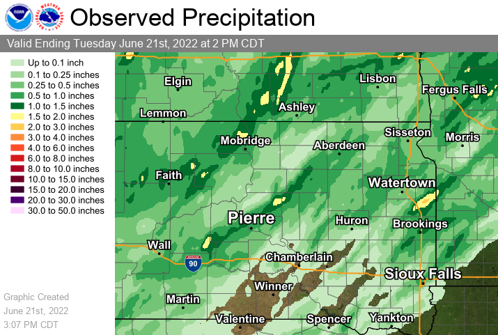
Rainfall, Lightning
Below is a map of radar-estimated rainfall amounts from 2pm on the 20th through 2pm on the 21st.
Below is a plot of observed cloud-to-ground lightning strikes, as recorded by the National Lightning Detection Network (NLDN) over a 24 hour period ending at 6pm on 6-21-2022. Red icons indicate negatively charged lightning strikes, whereas red indicate positively charged lightning strikes.

 |
Media use of NWS Web News Stories is encouraged! Please acknowledge the NWS as the source of any news information accessed from this site. |
|

