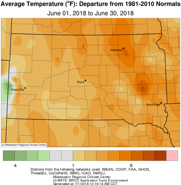
June 2018 was above average temperature-wise, from 2 to 6+ degrees. Portions of the James River Valley were warmest, as below average precipitation allowed for drier and thus warmer air here. The first half of the month was record-breaking in some cases, including 99° on the 14th and 97° on the 5th at Mobridge, 99° on the 5th in Pierre, 95° on the 5th in Watertown (daily records).
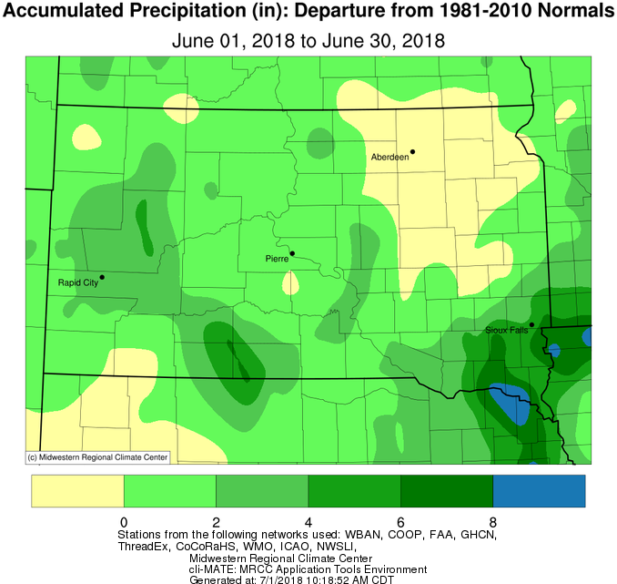
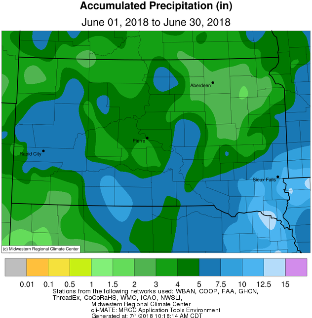
Much of central South Dakota and west central Minnesota received above average precipitation while portions of the Coteau and the James Valley were below average. Accordingly, and on the heels of a dry May as well, the James River Valley is where, on June 1st, high winds associated with thunderstorm activity produced a dust storm which greatly reduced visibility during the evening hours. (https://www.weather.gov/abr/2018June1_Severe_Dust). Drought, severe in some cases, persisted through the month across portions of the James River Valley despite an overall active weather pattern. Bad luck can be attributed to this relatively small region of drought. On the contrary, bouts of heavy rain occurred across the area as well. Watertown for instance picked up a daily record 1.84” of rain on the 11th, 1.55” of which fell in one hour from 10 to 11 am. Localized flooding resulted in town. Daily rainfall records were also set at Pierre (1.84” on the 27th) and Mobridge (1.09” on the 17th).
As is typical in June, impactful severe weather developed on a number of days. A line of storms during the evening of June 5th into the morning of June 6th produced widespread straight-line wind damage from Corson/Dewey counties to Grant county. A wind gust of 100 mph was recorded near Lowry (https://www.weather.gov/abr/20180605WindAndHail). On June 16th, two tornadoes developed near Burdette, and another touched down briefly near Claire City on the 24th (several funnel clouds this day as well). Finally, two separate large hailstorms affected generally the same area of Dewey, Sully, Hughes and Stanley counties on the early morning of 27th and on the evening of the 29th. Hail scars were visible via satellite in the following days as large swaths of cropland and other vegetation were pulverized.
|
JUNE 2018 |
||||
|
Temperature Data |
Aberdeen |
Sisseton |
Wheaton |
Watertown |
|
Warmest Temperature / Date |
101 / 5th |
92 / 5th |
89 / 29,30th |
94 / 5th |
|
Coldest Temperature / Date |
44 / 13th |
52 / 13th |
55 / 13th |
48 / 13th |
|
Average High / Departure from Normal |
84.7 / +7.3 |
82.1 / +4.8 |
80.4 / +3.1 |
79.9 / +3.2 |
|
Average Low / Departure from Normal |
59.5 / +5.8 |
60.5 / +5.7 |
62.4 / +6.3 |
60.3 / +5.8 |
|
Monthly Average / Departure from Normal |
72.1 / +6.5 |
71.3 / +5.2 |
71.4 / +4.7 |
70.1 / +4.5 |
|
Precipitation Data |
||||
|
Monthly Precipitation / Departure from Normal |
2.72 / -0.98 |
2.98 / -0.76 |
4.55 / +0.57 |
3.45 / -0.13 |
|
Most Precipitation in 24 hours / Date |
1.19 / 16th |
1.21 / 24th |
0.97 / 12th |
1.84 / 11th |
|
Temperature Data |
Pierre |
Kennebec |
Mobridge |
*Timber Lake |
|
Warmest Temperature / Date |
99 / 5th |
97 / 5th |
99 / 14th |
96 / 5th |
|
Coldest Temperature / Date |
45 / 13th |
46 / 13th |
48 / 13th |
47 / 3rd, 13th |
|
Average High / Departure from Normal |
82.6 / +2.6 |
84.3 / +2.4 |
82.7 / +4.9 |
80.4 / +1.9 |
|
Average Low / Departure from Normal |
58.9 / +3.5 |
59.3 / +3.5 |
60.1 / +6.3 |
56.5 / +2.9 |
|
Monthly Average / Departure from Normal |
70.7 / +3.0 |
71.8 / +3.0 |
65.8 / +5.6 |
68.5 / +2.4 |
|
Precipitation Data |
||||
|
Monthly Precipitation / Departure from Normal |
4.45 / +0.88 |
4.45 / +1.1 |
3.63 / +0.47 |
3.61 / +0.31 |
|
Most Precipitation in 24 hours / Date |
1.84 / 27th |
1.12 / 9th |
1.09 / 17th |
1.16 / 17th |
June 2018 temperature departures, from the Midwestern Regional Climate Center

June 2018 precipitation departures, from the Midwestern Regional Climate Center

June 2018 precipitation totals, from the Midwestern Regional Climate Center

Drought Monitor at the beginning and end of the month, from http://droughtmonitor.unl.edu/