
Catastrophic Super Typhoon Bavi's eyewall has reached Rota and is expected to bring dangerous winds, heavy rainfall and storm surge to Guam, Rota, Tinian and Saipan. A Typhoon Warning remains in effect. Heavy to excessive rainfall will continue to bring a flooding threat from coastal Mid-Atlantic to southern New England through Monday. Read More >
Overview
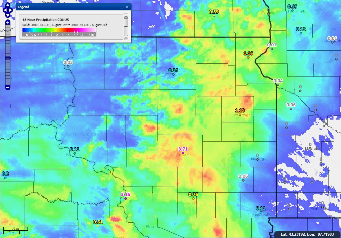
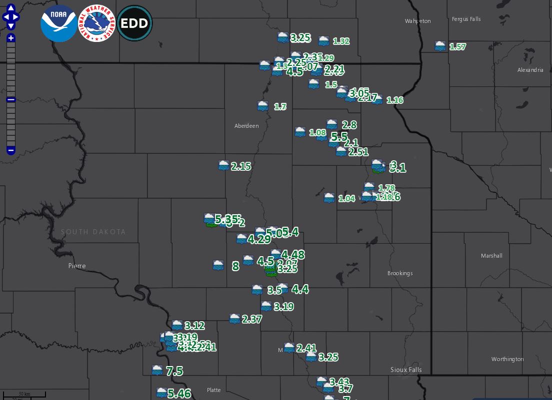
A very moist and stagnant atmosphere set the stage for heavy rains from slow-moving thunderstorms Friday morning, August 2nd. Several locations across the area observed up to 5-8". To make matters worse, this rain fell during a relatively short period of time with rainfall rates of 3+ inches per hour in some cases. As a result, flooding of property and several roadways resulted, and rivers rose to minor and moderate flood stages. Additional river rises to flood stage are forecast through the weekend as well, as a large volume of water continues to work its way through the river system.
Heavy Rain & Flooding
Rainfall and Flooding Reports Map, Hydrographs
 |
 |
 |
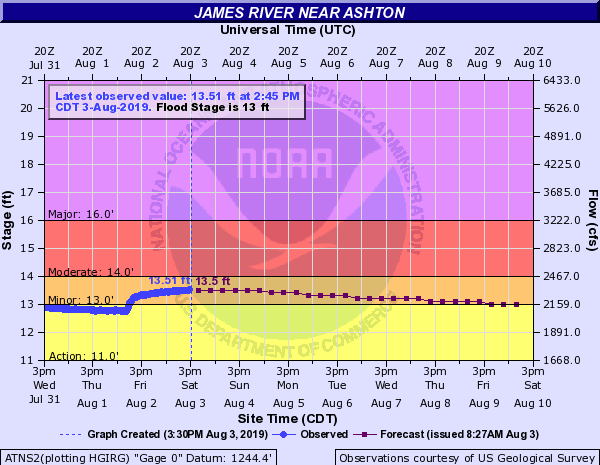 |
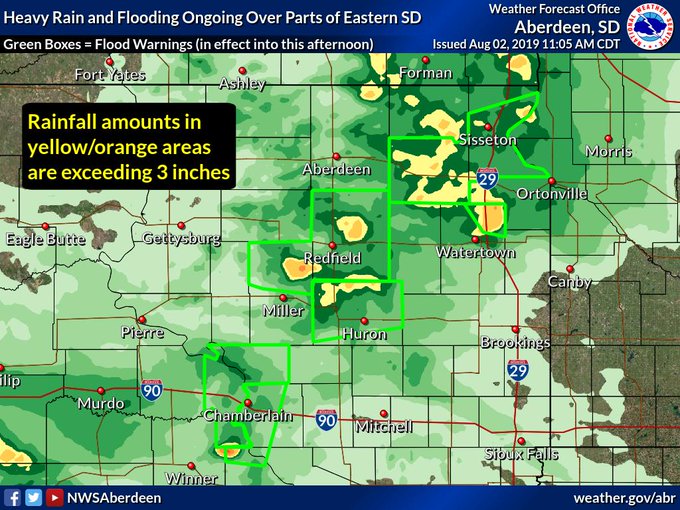
| Shading is of radar-estimated rainfall totals (underdone, despite our adjusting the radar to a setting more suitable for tropical environments) | Map of heavy rain and flooding reports across northeastern and central South Dakota | Extent of Flood Warnings as of 11am 8-2-19. Localized flooding continued in some areas into the day on the 3rd | Hydrograph for the James River near Ashton shows a spike in the river level into minor flood stage in response to the heavy rains |
 |
 |
 |
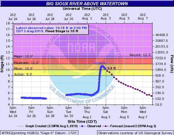 |
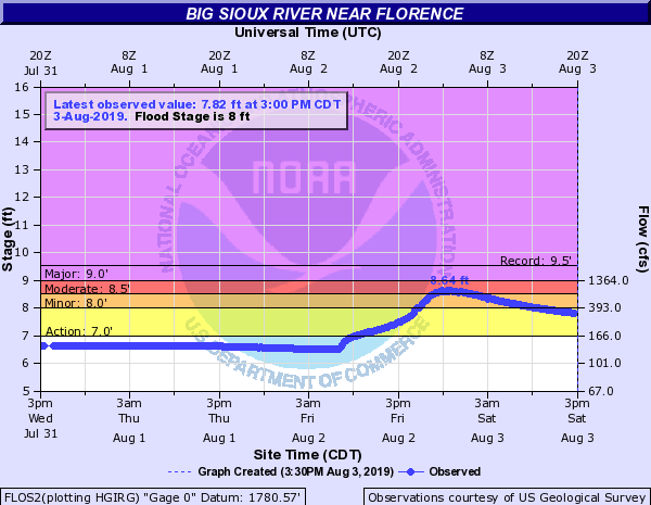
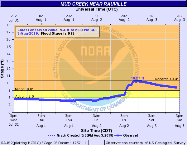
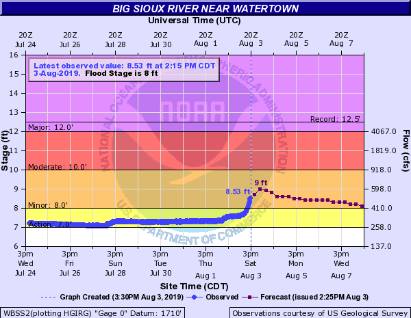
| Hydrograph for the Big Sioux River near Florence shows a spike in the river level into moderate flood stage in response to the heavy rains | Hydrograph for Mud Creek near Rauville shows a spike in the river level into minor flood stage in response to the heavy rains | Hydrograph for the Big Sioux River near Watertown shows a spike in the river level into minor flood stage in response to the heavy rains | Hydrograph for the Big Sioux River above Watertown shows a spike in the river level into minor flood stage in response to the heavy rains |
Listing of Rainfall and Flooding Reports
..TIME... ...EVENT... ...CITY LOCATION... ...LAT.LON...
..DATE... ....MAG.... ..COUNTY LOCATION..ST.. ...SOURCE....
..REMARKS..
0500 PM Heavy Rain 8 S Vayland 44.37N 98.80W
08/02/2019 M8.00 inch Hand SD Public
Updates previous heavy rain report from 8 S
Vayland. Public report relayed via the EM.
0500 PM Heavy Rain 2 W Iona 43.54N 99.47W
08/02/2019 M7.50 inch Lyman SD Public
Relayed via social media. Fell in under 3
hours.
1151 AM Heavy Rain 3 W Burdette 44.71N 98.87W
08/02/2019 E6.00 inch Hand SD Public
1031 AM Heavy Rain 5 ENE Bristol 45.38N 97.66W
08/02/2019 M5.50 inch Day SD Public
10 HOUR TOTAL. STILL RAINING.
0330 PM Heavy Rain 9 SSE Spink Colony 44.64N 98.20W
08/02/2019 M5.40 inch Spink SD Public
Relayed via social media.
1153 AM Heavy Rain 5 WNW Burdette 44.74N 98.90W
08/02/2019 M5.35 inch Hand SD Public
Updated rainfall total for this location.
0200 PM Heavy Rain 5 WNW South Shore 45.14N 97.02W
08/02/2019 M5.10 inch Codington SD Public
0307 PM Heavy Rain 8 E Spottswood 44.63N 98.34W
08/02/2019 E5.05 inch Spink SD Public
Relayed via social media.
1044 AM Heavy Rain 5 WNW Burdette 44.74N 98.90W
08/02/2019 M5.04 inch Hand SD Public
Report as of 10:44 am. Still raining.
0930 AM Heavy Rain 2 NNW Burdette 44.74N 98.83W
08/02/2019 M4.60 inch Hand SD Public
Report as of 9:30 AM, still raining.
0830 AM Heavy Rain Hecla 45.88N 98.15W
08/02/2019 M4.50 inch Brown SD Emergency Mngr
10 HOUR RAINFALL TOTAL.
0150 PM Heavy Rain Oacoma 43.80N 99.38W
08/02/2019 M3.25 inch Lyman SD Public
0600 PM Heavy Rain Roy Lake State Park 45.71N 97.44W
08/02/2019 M3.05 inch Marshall SD CO-OP Observer
0550 PM Heavy Rain 7 WNW South Shore 45.16N 97.06W
08/02/2019 M3.00 inch Grant SD CO-OP Observer
0750 AM Heavy Rain 3 WSW Roslyn 45.47N 97.55W
08/02/2019 M2.80 inch Day SD Public
Rainfall since about 4 AM CDT. Have had some
water in basement.
1000 AM Heavy Rain 7 SSE Webster 45.26N 97.45W
08/02/2019 M2.51 inch Day SD Trained Spotter
Still raining.
1200 PM Heavy Rain 4 E Watertown 44.92N 97.09W
08/02/2019 M2.50 inch Codington SD Public
12 HOUR TOTAL. STILL RAINING.
0700 AM Heavy Rain 1 SW Kidder 45.88N 97.72W
08/02/2019 M2.49 inch Marshall SD Cocorahs
0825 PM Heavy Rain 1 N Kidder 45.90N 97.71W
08/02/2019 M2.21 inch Marshall SD CO-OP Observer
0700 AM Heavy Rain 4 SE Lake City 45.68N 97.35W
08/02/2019 M2.17 inch Marshall SD Cocorahs
Cocorahs station SD-MR-13 Lake City 4 SE.
0310 PM Heavy Rain 3 E Watertown 44.91N 97.10W
08/02/2019 M2.16 inch Codington SD Broadcast Media
Relayed via social media.
1200 PM Heavy Rain 1 S Chelsea 45.15N 98.74W
08/02/2019 M2.15 inch Faulk SD Public
Still raining.
0800 AM Heavy Rain 1 WSW Webster 45.33N 97.53W
08/02/2019 M2.10 inch Day SD CO-OP Observer
0700 AM Heavy Rain 8 ENE Hecla 45.92N 98.00W
08/02/2019 M2.07 inch Brown SD CO-OP Observer
CO-OP Observer station BRTS2 Hecla 5 NE.
1030 AM Heavy Rain 4 E Burdette 44.71N 98.73W
08/02/2019 M2.00 inch Hand SD Public
Still raining.
1115 AM Heavy Rain 1 WNW Lake City 45.73N 97.43W
08/02/2019 M1.97 inch Marshall SD Trained Spotter
12 HOUR TOTAL. STILL RAINING.
0800 AM Heavy Rain 3 W Rauville 44.98N 97.14W
08/02/2019 M1.78 inch Codington SD CO-OP Observer
CO-OP Observer station RALS2 Rauville 2 W.
0521 PM Heavy Rain Columbia 45.61N 98.31W
08/02/2019 M1.70 inch Brown SD Emergency Mngr
0700 AM Heavy Rain Britton 45.78N 97.75W
08/02/2019 M1.50 inch Marshall SD CO-OP Observer
CO-OP Observer station BRIS2 Britton.
0700 AM Heavy Rain 7 WNW Hecla 45.92N 98.29W
08/02/2019 M1.30 inch Brown SD Cocorahs
Cocorahs station SD-BR-4 Hecla 7 WNW.
0700 AM Heavy Rain Columbia 45.61N 98.31W
08/02/2019 M1.30 inch Brown SD Emergency Mngr
0650 PM Heavy Rain Watertown 44.91N 97.17W
08/02/2019 M1.18 inch Codington SD ASOS
0651 PM Heavy Rain Sisseton 45.66N 97.05W
08/02/2019 M1.16 inch Roberts SD ASOS
1200 PM Heavy Rain Andover 45.41N 97.90W
08/02/2019 M1.08 inch Day SD CO-OP Observer
0330 PM Heavy Rain 4 S Garden City 44.90N 97.58W
08/02/2019 M1.04 inch Clark SD CO-OP Observer
1152 AM Flood 3 W Burdette 44.71N 98.87W
08/02/2019 Hand SD Public
Water over county and township roads, 6.0
inches of rain reported.
0732 AM Flood Webster 45.34N 97.52W
08/02/2019 Day SD Law Enforcement
WATER OVER SEVERAL AREA ROADWAYS.
1220 PM Flood 6 WNW South Shore 45.13N 97.04W
08/02/2019 Codington SD Public
County and township roads have water running
over them due to heavy rain.
Photos & Video
| 2 miles west of Iona, captured by and courtesy of Mark Kenzy around 1 pm, after his personal weather station recorded 7.5" of rain in less than 3 hours. A neighbor's KELO rain gauge measured 7.2" of rain as well. | Another video 2 miles west of Iona, captured by and courtesy of Mark Kenzy around 1 pm, after his personal weather station recorded 7.5" of rain in less than 3 hours. A neighbor's KELO rain gauge measured 7.2" of rain as well. |
 |
 |
 |
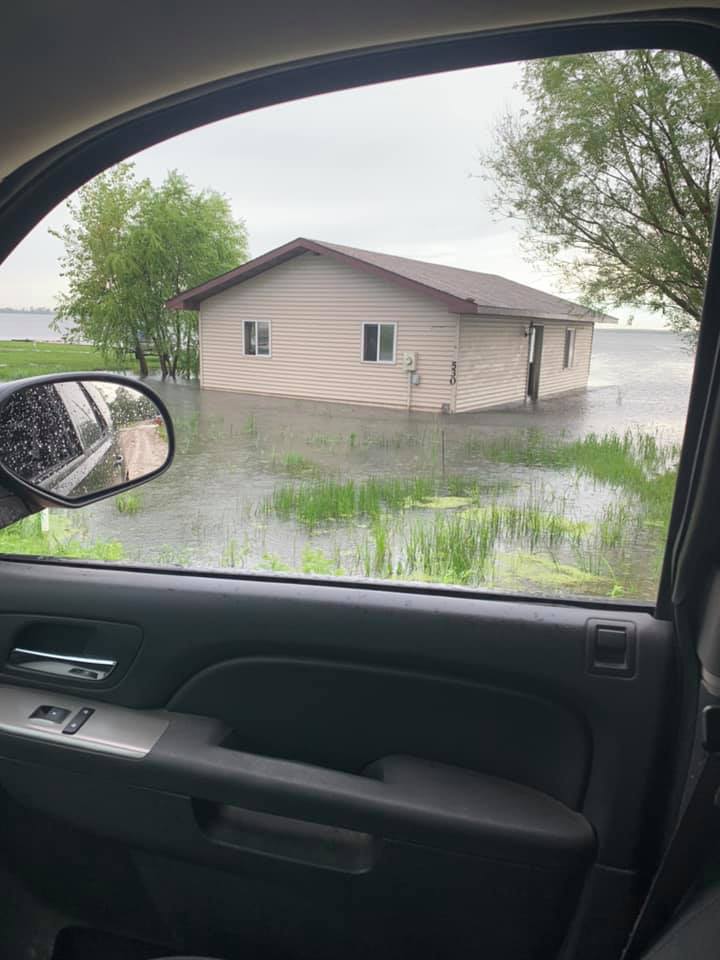 |
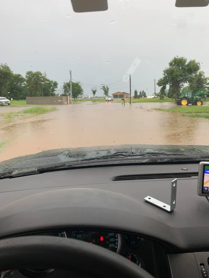
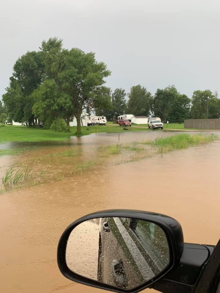
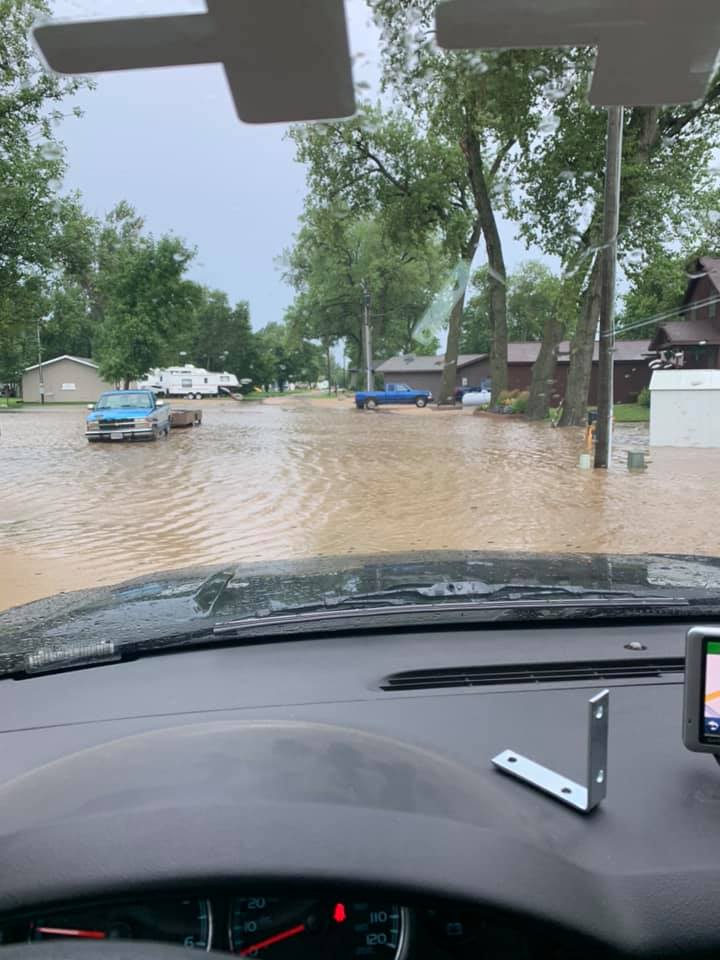
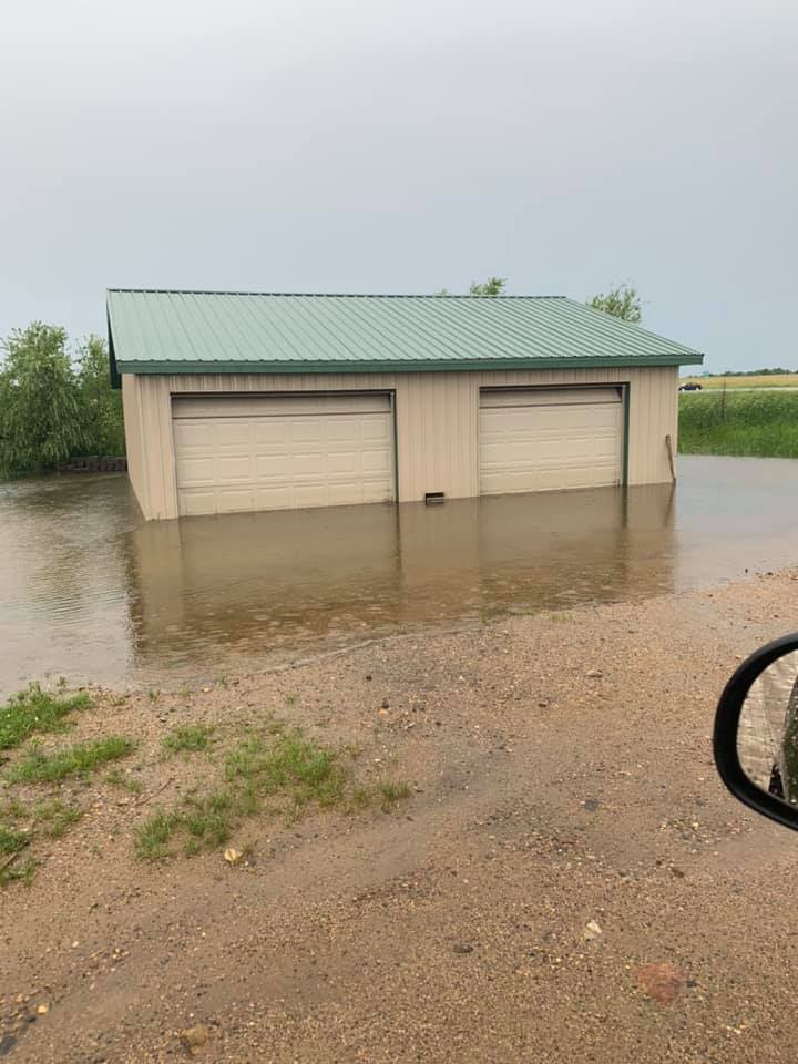
| Flooding at Blue Dog Lake. Photo by the Day County Sheriff | Flooding at Blue Dog Lake. Photo by the Day County Sheriff | Flooding at Blue Dog Lake. Photo by the Day County Sheriff | Flooding at Blue Dog Lake. Photo by the Day County Sheriff |
 |
 |
 |
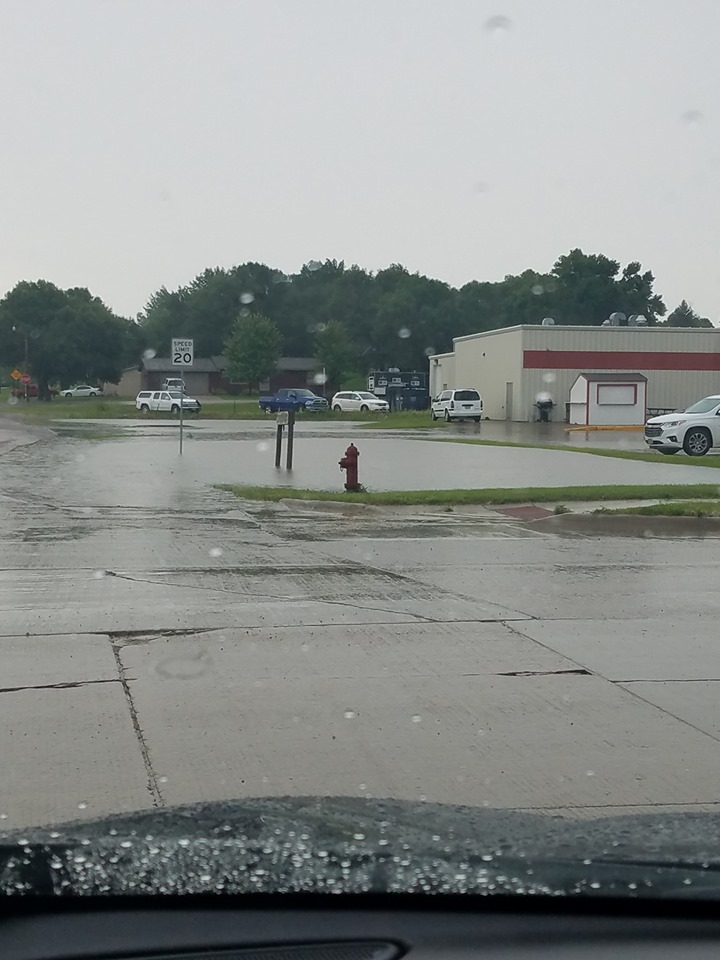 |
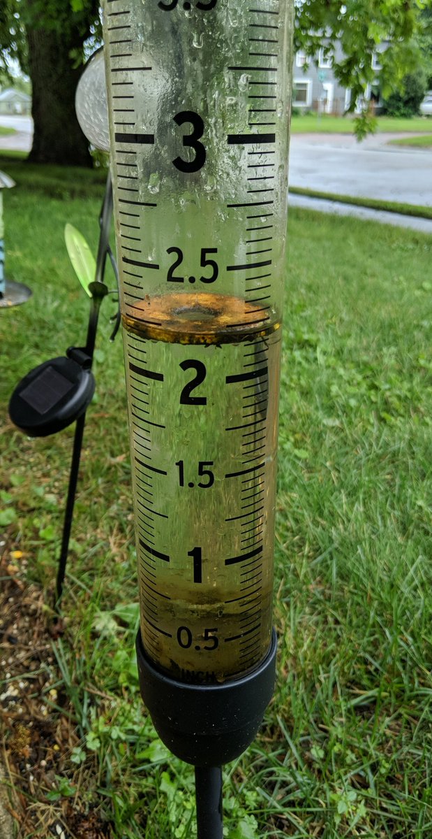
| Flooding at Blue Dog Lake. Photo by the Day County Sheriff | Rain gauge from Watertown, courtesy of Brent Nathaniel. A wide range of totals were observed with this event | Water over the roads in Watertown, courtesy of Brent Nathaniel | Ponding of water in Webster at the intersection of SD 25 and 14th Ave, courtesy of Daniel Basler Jr |
Radar
 |
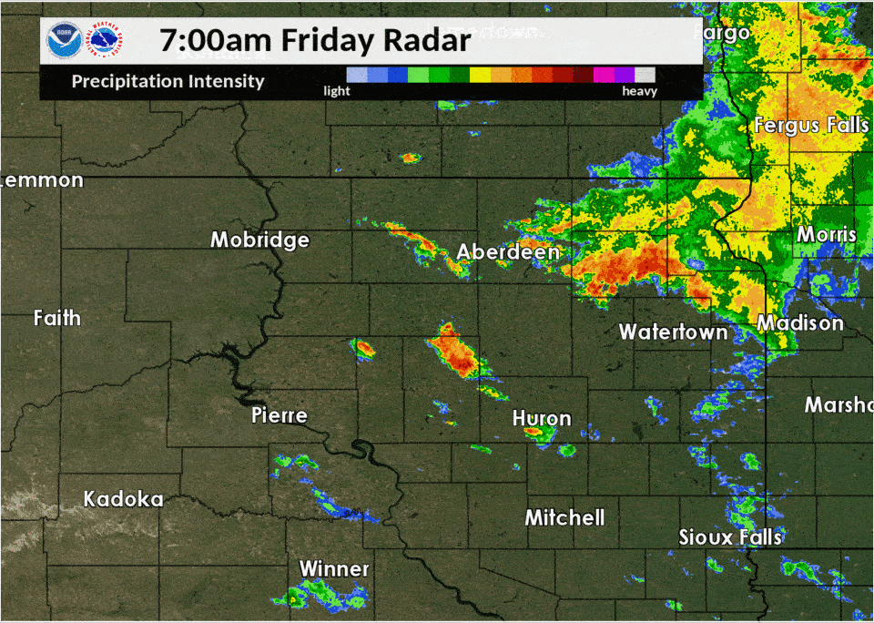 |
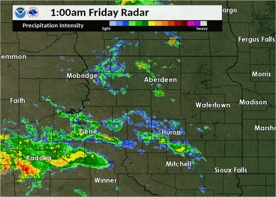
| Radar imagery from 1am to 7am 8-2-19 | Radar imagery from 7am to 1pm 8-2-19 |
 |
Media use of NWS Web News Stories is encouraged! Please acknowledge the NWS as the source of any news information accessed from this site. |
|

