Gusty winds and dry conditions will continue to bring elevated to critical fire weather conditions to the southern Plains and Southeast early this week. A Pacific storm system will bring low elevation rain and heavy high elevation mountain snow to northern and central California through early week, expanding into the Pacific Northwest, Great Basin, and southern California on Tuesday. Read More >
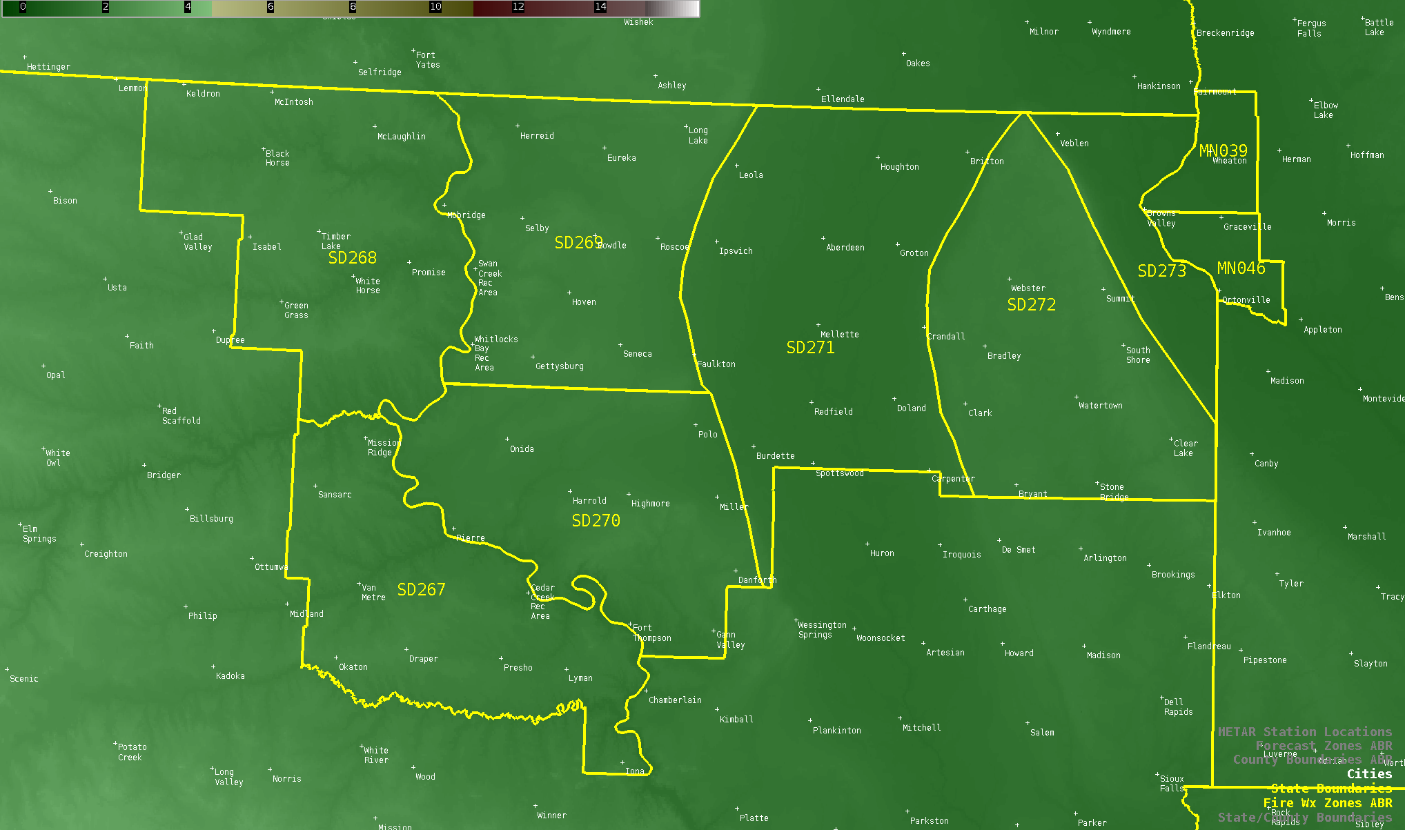
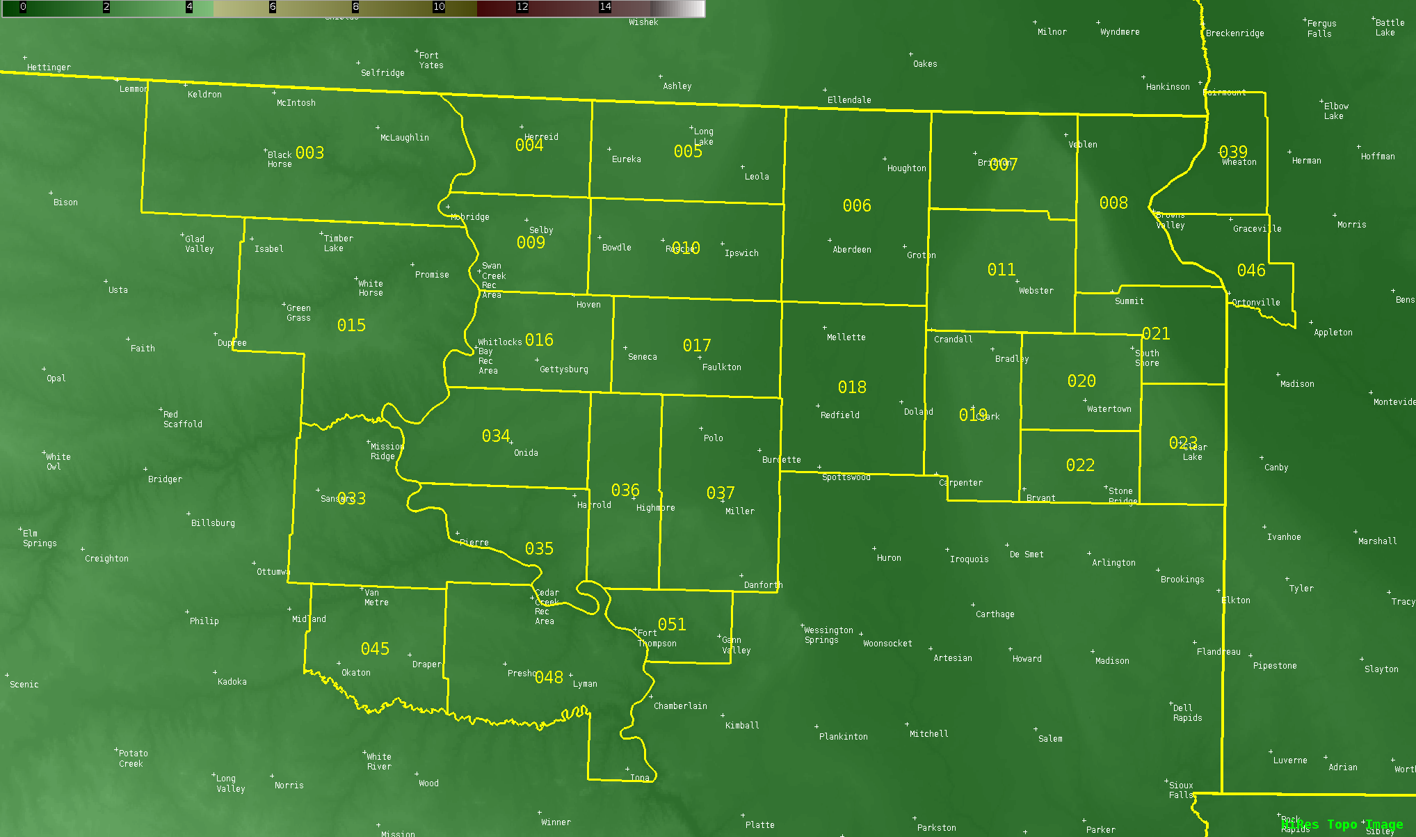
Effective October 29th, 2020, the National Weather Service forecast office in Aberdeen, SD (ABR) will modify fire weather zone boundaries across central and northeast South Dakota. The purpose of this change is to better meet the needs of fire partners and improve fire weather support, including improved watch, warning, and forecast products. The new fire weather forecast zone boundaries will align with county boundaries. These changes were necessary to create more detailed fire weather forecasts by reducing the size of the fire zones and resultant forecast area.
The change in fire zone boundaries will require new fire weather zone numbers. Details of these zone number changes are listed in the table below:
| Current Fire Zone Numbers | Future Fire Zone Numbers (October 29, 2020) |
| SDZ267 - Lower Bad River | SDZ003 - Corson |
| SDZ268 - Upper Cheyenne | SDZ004 - Campbell |
| SDZ269 - Upper Missouri Coteau | SDZ005 - McPherson |
| SDZ270 - Missouri Coteau | SDZ006 - Brown |
| SDZ271 - Upper James River | SDZ007 - Marshall |
| SDZ272 - Prairie Coteau | SDZ008 - Roberts |
| SDZ273 - Red River Valley | SDZ009 - Walworth |
| SDZ010 - Edmunds | |
| SDZ011 - Day | |
| SDZ015 - Dewey | |
| SDZ016 - Potter | |
| SDZ017 - Faulk | |
| SDZ018 - Spink | |
| SDZ019 - Clark | |
| SDZ020 - Codington | |
| SDZ021 - Grant | |
| SDZ022 - Hamlin | |
| SDZ023 - Deuel | |
| SDZ033 - Stanley | |
| SDZ034 - Sully | |
| SDZ035 - Hughes | |
| SDZ036 - Hyde | |
| SDZ037 - Hand | |
| SDZ045 - Jones | |
| SDZ048 - Lyman | |
| SDZ051 - Buffalo |
Graphical descriptions of the old and new fire weather zones are available below:
Current Fire Weather Zones

Future Fire Weather Zones on October 29, 2020

NWS watch, warning, and forecast products affected by these changes are:
| NWS Aberdeen Products | WMO Heading | AWIPS ID |
| Fire Weather Watch | WWUS83 KABR | RFWABR |
| Red Flag Warning | WWUS83 KABR | RFWABR |
| Fire Weather Planning Forecast | FNUS53 KABR | FWFABR |
NWS partners and users will need to make necessary changes to their communications systems to accommodate these fire weather forecast zone changes. A shapefile of the new fire weather forecast zones for NWS ABR is online at: http://www.nws.noaa.gov/geodata/catalog/wsom/html/firezone.htm
For more information, please contact:
Travis Tarver - Fire Weather Program Manager
824 Brown County 14 S.
Aberdeen, SD 57401
605-290-0292
travis.tarver@noaa.gov
National Service Change Notices are online at: http://www.weather.gov/os/notif.htm
Service Chance Notice issued Wednesday, August 12, 2020