Overview
|
All images on this page may be expanded with a single click and returned to original size with a second click. Starting all the way back on February 1st, an upper-level low began to take shape over Alaska. Over the course of the next week, the system would intensify and traverse thousands of miles to arrive on the doorstep of the Florida peninsula. By February 6th, a potent setup had taken shape, with a strong cold front extending into the Gulf of America. Across Florida, temperatures were warm and humid. Breezy southerly flow had transported large amounts of moist, tropical air northward, allowing temperatures to climb into the mid-80s. Behind the front, conditions were cold and dry as northern arctic air funneled south. This distinct difference, a common occurrence in winter, had an extra boost as the jet stream dipped farther to the south, producing strong, gusty winds near the surface. What was already a favorable environment for storms had become even better. All across the peninsula, many would report strong winds and minor damage. However, what is most likely to be the most memorable element of the event was the EF-0 tornado that impacted parts of Pinellas County; uprooting trees, damaging homes, and even toppling a crane onto I-275. |
||
|
Infrared Satellite
|
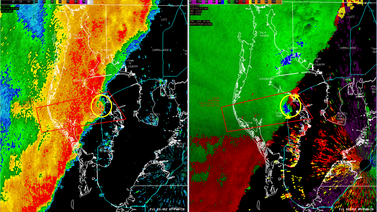
Radar Loop 02/06/2020 - 02/07/2020
|
|
Tornado:
|
Tornado - Seminole → Pinellas Park
 |
||||||||||||||||||||||
The Enhanced Fujita (EF) Scale classifies tornadoes into the following categories:
| EF0 Weak 65-85 mph |
EF1 Moderate 86-110 mph |
EF2 Significant 111-135 mph |
EF3 Severe 136-165 mph |
EF4 Extreme 166-200 mph |
EF5 Catastrophic 200+ mph |
 |
|||||
Photos
Pinellas County EF-0 Tornado:
 |
 |
| Photo Credit: WTVT | Photo Credit: Spectrum Bay News 9 |
 |
 |
| Photo Credit: WTSP | Photo Credit: WFLA |
 |
 |
| Photo Credit: WFTS | Photo Credit: WFTS |
 |
|
| Photo Credit: WTVT |
Other Wind Damage:
 |
 |
| Photo Credit: Public | Photo Credit: Public |
 |
 |
| Photo Credit: WFTS | Photo Credit: WFTS |
 |
 |
| Photo Credit: WFLA | Photo Credit: Hardee County EM |
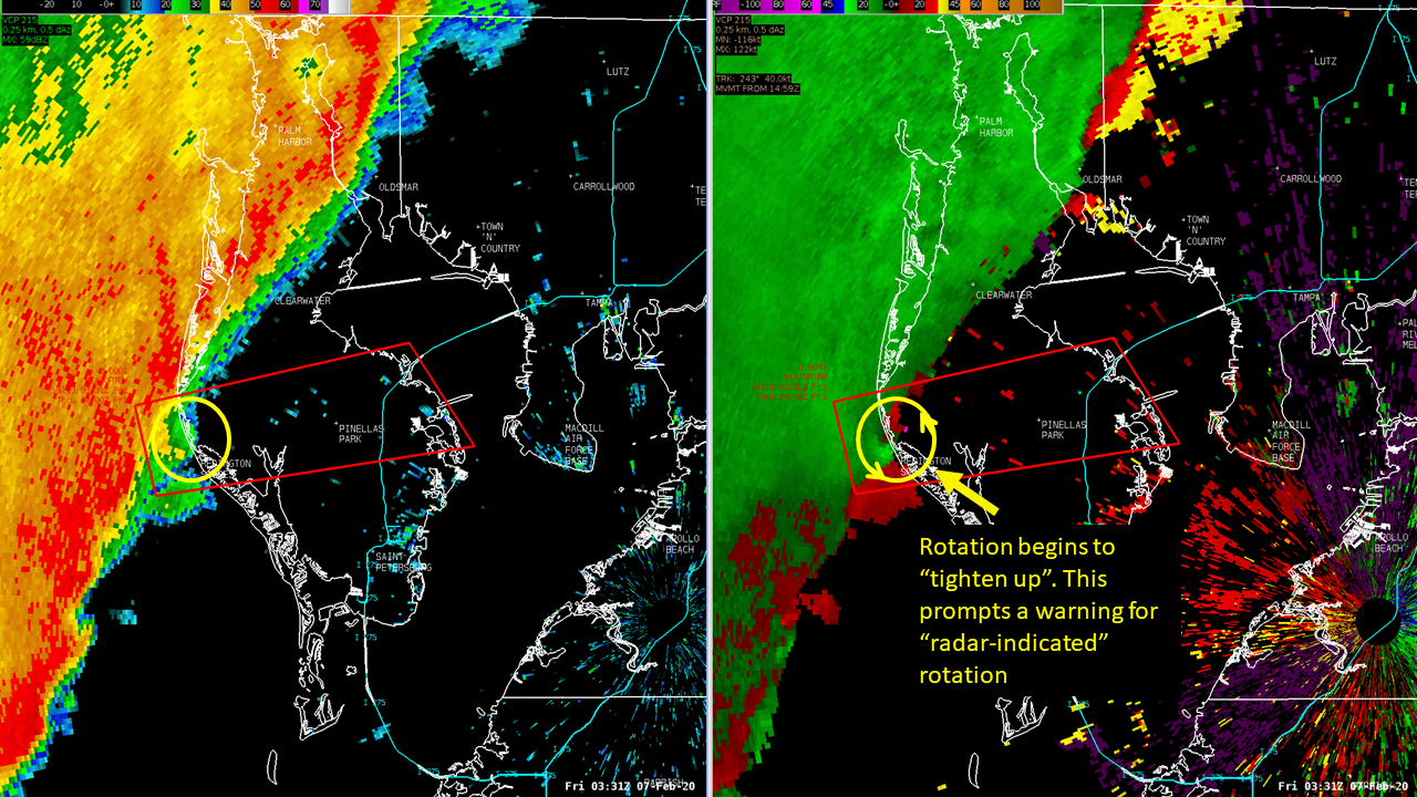
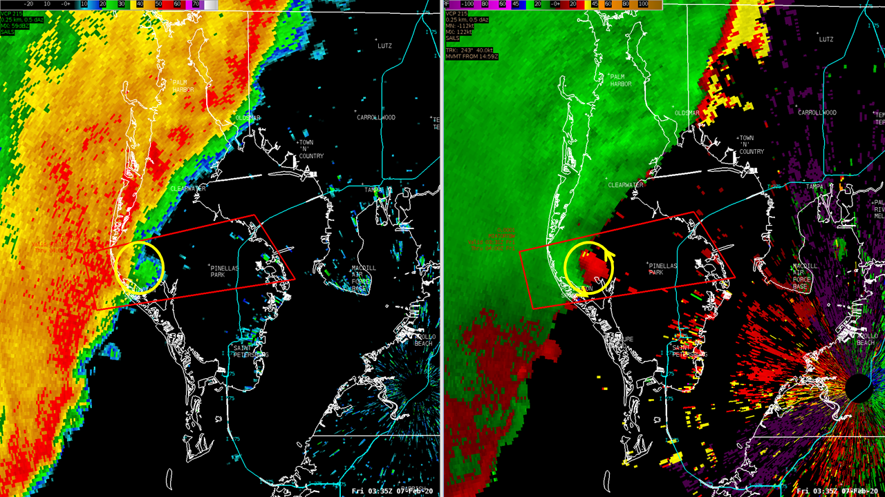
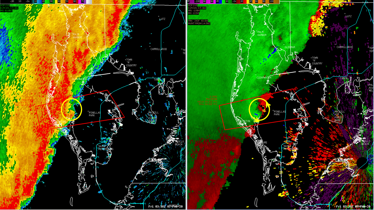
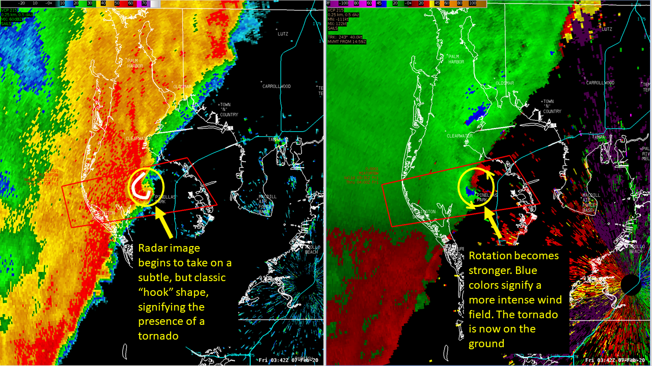
Radar
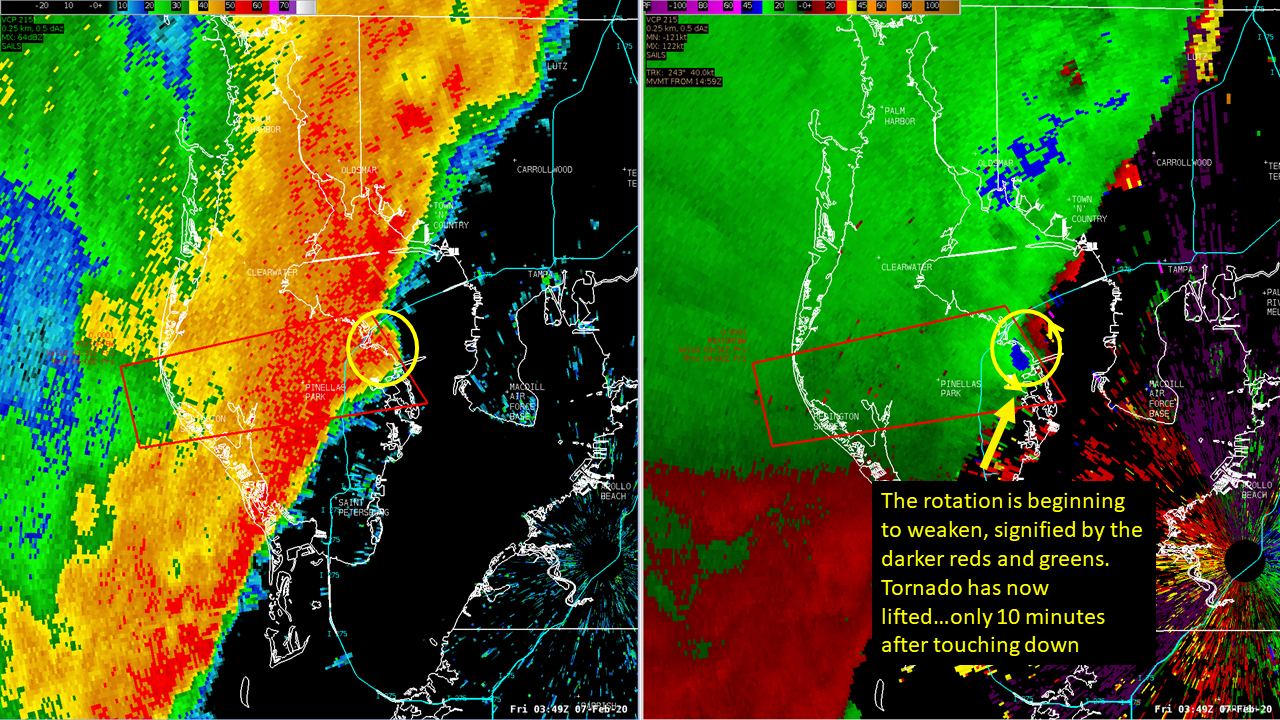
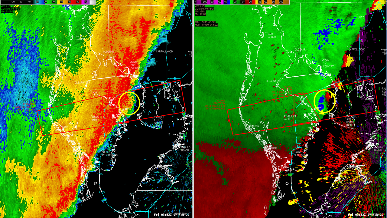
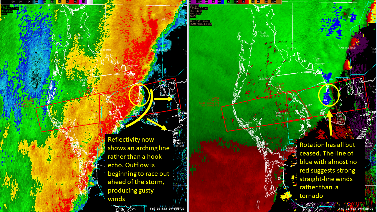
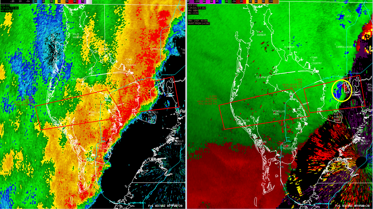
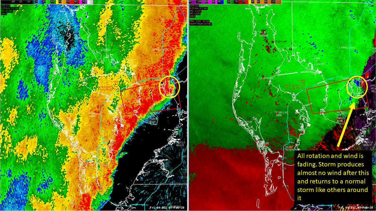
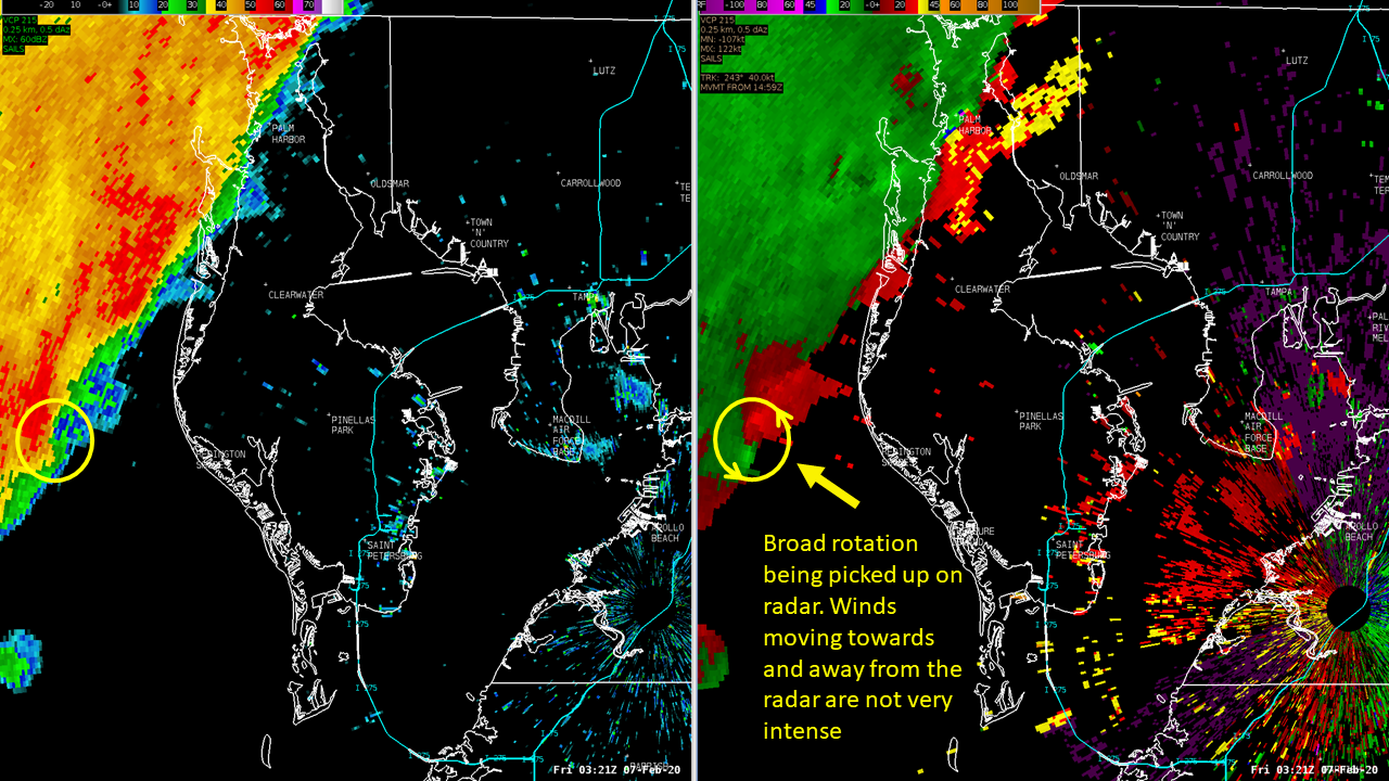
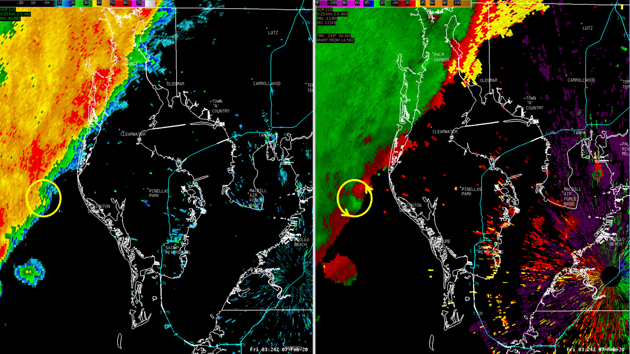
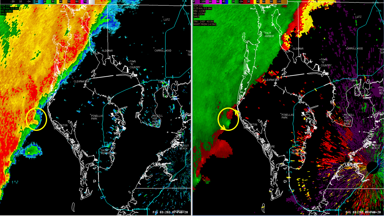
Radar Snapshots:
 |
 |
 |
 |
|
Pinellas County - February 6, 2020 |
|||
|
Rainfall:
The entire region saw some rain as the squall line moved through, but the duration of the heavy rainfall was less than 1 hour so rainfall amounts were generally between 0.50 and 1 inch.
 rainfall estimation statistics") |
| MRMS (Multi-Sensor-Multi-Radar) rainfall estimation statistics across the region for the event. |
Environment
A well defined cold front was approaching the region at 03 UTC/10 PM EST on February 6th as seen in Figure 1 below. Figure 1 shows strong frontogenesis ongoing in the 1000-850mb layer at 10 PM EST. The frontogenetic forcing served as focused low level lift within the thermal circulation on the warm side of the boundary. Surface based convection in the from of a quasi-linear convective system (QLCS) squall-line was rapidly approaching the coast at this time. Figure 2 (center) indicates a substantial tongue of boundary layer CAPE over the coastal waters, with less, but still positive values along the coastal landmass. Figure 3 (right) shows very strong deep (0-6km) layer environmental bulk shear in place across the region, in excess of 60 knots coincident with the leading edge of the squall-line. This strong shear profile no doubt was aiding both the organization and depth of the convective updrafts.
 |
 |
 environmental Bulk Shear") |
| Fig 1) Feb 6th, 2020 - 10 PM EST | Fig 2) Feb 6th, 2020 - 10 PM EST | Fig 3) Feb 6th, 2020 - 10 PM EST |
Impressive 0-3km helicity values in excess of 400 from Tampa Bay northward (Fig 4), and 0-1km helicity values in the 300-400 range (Fig 5) suggested a favorable environment of supercell-like structures to form embedded within the line structure. One segment of the line ingesting this environment began to exhibit some supercell characteristics shortly after 10 PM EST, to the southwest of the Pinellas County coast. This particularly robust convective cell further interacted with the deep layer shear, with upgrowth convective evolution along the direction of the deep layer shear vector. This evolution brought this segment of the line more orthogonal to the 0-3km shear vector, favoring a shear dominated cold pool, and greater potential for meso-vortex development. When a meso-vortex did begin to develop, the lower level processes where almost certainly complimented/coupled by deeper layer updraft processes owing to the 0-6km bulk shear vector. Some signs of this can be extrapolated from the 3D 50dBZ radar rendering in Fig 6 below. The cell/line segment with the developing meso-vortex is exhibiting morphology suggestive of an enhanced/deeper updraft, compared to flanking cells, where the 50dBZ echo is elevated by the strong updraft. This deeper, more robust updraft was what likely led to the surface tornadogenesis over inland Pinellas County during the next 5-10 minutes.
 |
 |
 |
| Fig 4) Feb 6th, 2020 - 10 PM EST | Fig 5) Feb 6th, 2020 - 10 PM EST | Fig 6) Feb 6th, 2020 - 10:30 PM EST |
Coastal Flooding
Tide Charts:
The squall-line resulted in minor coastal flooding issues along the northeast Gulf of America. The highest tide cycle associated with the storm ranged from generally 1-3 feet above normal from Apalachicola around the Florida Big Bend and down to portions of Pinellas County. The higher than normal tides from Cedar Key southward resulted in brief periods of tidal over-wash, a few closed roads, and minor beach erosion.
 |
 |
 |
| Cedar Key, FL | Yankeetown, FL | New Port Richey, FL |
 |
 |
 |
| Clearwater Beach, FL | St Petersburg, FL | Riverview, FL |
Meteotsunami Plots:
The highest departures from the predicted tides occurred as the squall line was moving onshore creating what is referred to as a "Meteotsunami" which is a small, weather-driven tsunami caused by changes in air pressure created by fast-moving severe thunderstorms, tropical storms, squalls or other storm fronts.
 |
| Cedar Key, FL |
 |
| Clearwater Beach, FL |
 |
| St Petersburg, FL |
 |
| Naples, FL |
Text Products
Wind/Lake Wind Advisory issued at 359 AM EST
URGENT - WEATHER MESSAGE
National Weather Service Tampa Bay Ruskin FL
359 AM EST Thu Feb 6 2020

FLZ043-050-052-056-057-061-139-142-148-149-151-155-160-239-242-
248-249-251-255-260-061700-
/O.NEW.KTBW.WI.Y.0001.200206T1800Z-200207T1200Z/
Sumter-Pinellas-Polk-Hardee-Highlands-DeSoto-Coastal Levy-
Coastal Citrus-Coastal Hernando-Coastal Pasco-
Coastal Hillsborough-Coastal Manatee-Coastal Sarasota-Inland Levy-
Inland Citrus-Inland Hernando-Inland Pasco-Inland Hillsborough-
Inland Manatee-Inland Sarasota-
Including the cities of Wildwood, Lake Panasoffkee, Bushnell,
The Villages, St. Petersburg, Clearwater, Largo, Lakeland,
Winter Haven, Wauchula, Bowling Green, Zolfo Springs, Sebring,
Avon Park, Placid Lakes, Arcadia, Cedar Key, Yankeetown,
Crystal River, Homosassa, Hernando Beach, Bayport, Port Richey,
Hudson, Tampa, Apollo Beach, Westchase, Bradenton,
Anna Maria Island, Venice, Sarasota, Englewood, Chiefland,
Bronson, Williston, Inverness, Brooksville, Spring Hill,
Dade City, Zephyrhills, Brandon, Plant City, Sun City Center,
Parrish, Lakewood Ranch, Myakka City, and North Port
359 AM EST Thu Feb 6 2020

...WIND ADVISORY IN EFFECT FROM 1 PM THIS AFTERNOON TO 7 AM EST
FRIDAY...

* WHAT...Southwest winds 20 to 25 mph with gusts up to 45 mph
  expected.

* WHERE...Portions of west central Florida.

* WHEN...From 1 PM this afternoon to 7 AM EST Friday.

* IMPACTS...Gusty winds could blow around unsecured objects.
  Tree limbs could be blown down and a few power outages may
  result.

* ADDITIONAL DETAILS...Winds will increase during the day Thursday
  into Thursday Night.

PRECAUTIONARY/PREPAREDNESS ACTIONS...

Use extra caution when driving, especially if operating a high
profile vehicle. Secure outdoor objects.

&&

$$

FLZ162-165-262-265-061700-
/O.NEW.KTBW.LW.Y.0001.200206T1800Z-200207T1200Z/
Coastal Charlotte-Coastal Lee-Inland Charlotte-Inland Lee-
Including the cities of Port Charlotte, Punta Gorda, Cape Coral,
Captiva, Sanibel, Babcock Ranch, Fort Myers, and Lehigh Acres
359 AM EST Thu Feb 6 2020

...LAKE WIND ADVISORY IN EFFECT FROM 1 PM THIS AFTERNOON TO 7 AM
EST FRIDAY...

* WHAT...Southwest winds 15 to 25 mph with gusts up to 35 mph
  expected.

* WHERE...Coastal Charlotte, Coastal Lee, Inland Charlotte and
  Inland Lee Counties.

* WHEN...From 1 PM this afternoon to 7 AM EST Friday.

* IMPACTS...Strong winds and rough waves on area lakes will
  create hazardous conditions for small craft.


PRECAUTIONARY/PREPAREDNESS ACTIONS...

Boaters on area lakes should use extra caution since strong winds
and rough waves can overturn small craft.

&&

$$

For more information from the National Weather Service visit

https://weather.gov/tampa
Tornado Watch issued at 532 PM EST
WATCH COUNTY NOTIFICATION FOR WATCH 32
NATIONAL WEATHER SERVICE TAMPA BAY AREA - RUSKIN FL
532 PM EST THU FEB 6 2020

FLC017-075-070500-
/O.NEW.KTBW.TO.A.0032.200206T2232Z-200207T0500Z/

THE NATIONAL WEATHER SERVICE HAS ISSUED TORNADO WATCH 32 IN
EFFECT UNTIL MIDNIGHT EST TONIGHT FOR THE FOLLOWING AREAS

IN FLORIDA THIS WATCH INCLUDES 2 COUNTIES

IN NORTHERN FLORIDA

LEVY

IN WEST CENTRAL FLORIDA

CITRUS

THIS INCLUDES THE CITIES OF BEVERLY HILLS, BRONSON, CEDAR KEY,
CHIEFLAND, CITRUS SPRINGS, FANNING SPRINGS, FLORAL CITY,
HERNANDO, HOMOSASSA SPRINGS, INVERNESS, LECANTO, AND WILLISTON.
Severe Thunderstorm Warning issued at 833 PM EST
BULLETIN - IMMEDIATE BROADCAST REQUESTED
Severe Thunderstorm Warning
National Weather Service Tampa Bay Area Ruskin FL
833 PM EST Thu Feb 6 2020

The National Weather Service in Ruskin has issued a

* Severe Thunderstorm Warning for...
  Levy County in northern Florida...

* Until 930 PM EST.

* At 831 PM EST, severe thunderstorms were located along a line
  extending from near Cross City to 59 miles west of Hudson, moving
  east at 35 mph.

  HAZARD...60 mph wind gusts.

  SOURCE...Radar indicated.

  IMPACT...Expect damage to roofs, siding, and trees.

* Locations impacted include...
  Chiefland, Bronson, East Bronson, Fowlers Bluff, Andrews, Manattee
  Road, Williston Highlands, Inglis, Fanning Springs, Otter Creek,
  Lebanon and Manatee Springs State Park.

PRECAUTIONARY/PREPAREDNESS ACTIONS...

A Tornado Watch remains in effect until midnight EST for northern and
west central Florida.

Remain alert for a possible tornado! Tornadoes can develop quickly
from severe thunderstorms. If you spot a tornado go at once into a
small central room in a sturdy structure.

For your protection move to an interior room on the lowest floor of a
building.

&&

LAT...LON 2929 8316 2935 8306 2959 8294 2957 8266
      2954 8265 2954 8256 2948 8255 2948 8248
      2903 8268 2900 8275 2899 8273 2894 8272
      2897 8283 2910 8289 2911 8294 2904 8302
      2906 8313 2917 8317
TIME...MOT...LOC 0131Z 262DEG 31KT 2964 8319 2861 8364

TORNADO...POSSIBLE
HAIL...<.75IN
WIND...60MPH

$$

TBW
Tornado Watch issued at 927 PM EST
WATCH COUNTY NOTIFICATION FOR WATCHES 32/33
NATIONAL WEATHER SERVICE TAMPA BAY AREA - RUSKIN FL
927 PM EST THU FEB 6 2020

FLC015-027-049-053-055-057-071-081-101-103-105-115-119-070800-
/O.NEW.KTBW.TO.A.0033.200207T0227Z-200207T0800Z/

THE NATIONAL WEATHER SERVICE HAS ISSUED TORNADO WATCH 33 IN
EFFECT UNTIL 3 AM EST FRIDAY FOR THE FOLLOWING AREAS

IN FLORIDA THIS WATCH INCLUDES 13 COUNTIES

IN CENTRAL FLORIDA

HARDEE                POLK                  SUMTER

IN SOUTH CENTRAL FLORIDA

DESOTO                HIGHLANDS

IN SOUTHWEST FLORIDA

CHARLOTTE             LEE

IN WEST CENTRAL FLORIDA

HERNANDO              HILLSBOROUGH          MANATEE
PASCO                 PINELLAS              SARASOTA

THIS INCLUDES THE CITIES OF ARCADIA, AVON PARK, BAYSHORE GARDENS,
BONITA SPRINGS, BOWLING GREEN, BRADENTON, BRANDON, BROOKSVILLE,
BUSHNELL, CAPE CORAL, CLEARWATER, DADE CITY, ENGLEWOOD,
FORT MYERS, HOLIDAY, HUDSON, JASMINE ESTATES, LAKE PANASOFFKEE,
LAKELAND, LAND O LAKES, LARGO, LEHIGH ACRES, NEW PORT RICHEY,
NORTH FORT MYERS, NORTH PORT, PALMETTO, PLACID LAKES,
PORT CHARLOTTE, PUNTA GORDA, SARASOTA, SEBRING, SOUTH VENICE,
SPRING HILL, ST. PETERSBURG, TAMPA, THE VILLAGES, VENICE,
WAUCHULA, WILDWOOD, WINTER HAVEN, ZEPHYRHILLS, AND ZOLFO SPRINGS.

$$

GMZ830-836-850-853-856-070800-
/O.NEW.KTBW.TO.A.0033.200207T0227Z-200207T0800Z/

THE NATIONAL WEATHER SERVICE HAS ISSUED TORNADO WATCH 33 IN
EFFECT UNTIL 3 AM EST FRIDAY FOR THE FOLLOWING AREAS

THIS WATCH INCLUDES THE FOLLOWING ADJACENT COASTAL WATERS

TAMPA BAY WATERS      CHARLOTTE HARBOR AND PINE ISLAND SOUND
COASTAL WATERS FROM TARPON SPRINGS TO SUWANNEE RIVER FL OUT 20 NM
COASTAL WATERS FROM ENGLEWOOD TO TARPON SPRINGS FL OUT 20 NM
COASTAL WATERS FROM BONITA BEACH TO ENGLEWOOD FL OUT 20 NM

$$

FLC017-075-070500-
/O.CON.KTBW.TO.A.0032.000000T0000Z-200207T0500Z/

TORNADO WATCH 32 REMAINS VALID UNTIL MIDNIGHT EST TONIGHT FOR THE
FOLLOWING AREAS

IN FLORIDA THIS WATCH INCLUDES 2 COUNTIES

IN NORTHERN FLORIDA

LEVY

IN WEST CENTRAL FLORIDA

CITRUS

THIS INCLUDES THE CITIES OF BEVERLY HILLS, BRONSON, CEDAR KEY,
CHIEFLAND, CITRUS SPRINGS, FANNING SPRINGS, FLORAL CITY,
HERNANDO, HOMOSASSA SPRINGS, INVERNESS, LECANTO, AND WILLISTON.

$$
Severe Thunderstorm Warning issued at 928 PM EST
BULLETIN - IMMEDIATE BROADCAST REQUESTED
Severe Thunderstorm Warning
National Weather Service Tampa Bay Area Ruskin FL
928 PM EST Thu Feb 6 2020

The National Weather Service in Ruskin has issued a

* Severe Thunderstorm Warning for...
  Western Citrus County in west central Florida...
  Levy County in northern Florida...

* Until 1015 PM EST.

* At 928 PM EST, severe thunderstorms were located along a line
  extending from 8 miles northwest of Archer to 37 miles west of
  Harbor Bluffs, moving east at 35 mph.

  HAZARD...60 mph wind gusts.

  SOURCE...Radar indicated.

  IMPACT...Expect damage to roofs, siding, and trees.

* Locations impacted include...
  Williston, Bronson, Homosassa Springs, Beverly Hills, Williston
  Highlands, East Bronson, Crystal River Airport, Williston Municipal
  Airport, Black Diamond, Homosassa, Sugarmill Woods, Inglis, Otter
  Creek, Lecanto, Green Acres, Citronelle, Crystal Manor, Crystal
  Oaks, Citrus Springs and Pine Ridge.

PRECAUTIONARY/PREPAREDNESS ACTIONS...

A Tornado Watch remains in effect until midnight EST for northern and
west central Florida. A Tornado Watch also remains in effect until
300 AM EST for west central Florida.

Remain alert for a possible tornado! Tornadoes can develop quickly
from severe thunderstorms. If you spot a tornado go at once into a
small central room in a sturdy structure.

For your protection move to an interior room on the lowest floor of a
building.

&&

LAT...LON 2954 8256 2948 8255 2948 8241 2943 8240
      2922 8240 2921 8254 2904 8254 2901 8240
      2869 8258 2867 8266 2866 8264 2867 8270
      2867 8276 2880 8282 2892 8277 2910 8289
      2911 8294 2905 8300 2906 8300 2957 8269
TIME...MOT...LOC 0228Z 265DEG 30KT 2959 8265 2804 8342

TORNADO...POSSIBLE
HAIL...<.75IN
WIND...60MPH

$$

TBW
Severe Thunderstorm Warning issued at 1002 PM EST
BULLETIN - IMMEDIATE BROADCAST REQUESTED
Severe Thunderstorm Warning
National Weather Service Tampa Bay Area Ruskin FL
1002 PM EST Thu Feb 6 2020

The National Weather Service in Ruskin has issued a

* Severe Thunderstorm Warning for...
  Citrus County in west central Florida...
  Northwestern Sumter County in central Florida...
  Central Pasco County in west central Florida...
  Hernando County in west central Florida...
  Southeastern Levy County in northern Florida...
  Pinellas County in west central Florida...
  Northwestern Hillsborough County in west central Florida...

* Until 1100 PM EST.

* At 1002 PM EST, severe thunderstorms were located along a line
  extending from near Williston to 8 miles southwest of Homosassa to
  36 miles southwest of Harbor Bluffs, moving east at 30 mph.

  HAZARD...60 mph wind gusts.

  SOURCE...Radar indicated.

  IMPACT...Expect damage to roofs, siding, and trees.

* Locations impacted include...
  Tampa, Spring Hill, Clearwater, Largo, Pinellas Park, Seminole, New
  Port Richey, Brooksville, Inverness, Wildwood, Williston, Bushnell,
  Downtown Saint Petersburg, Hudson, Beverly Hills, Holiday,
  Homosassa Springs, Saint Petersburg, Lutz and Fort Desoto Park.

PRECAUTIONARY/PREPAREDNESS ACTIONS...

A Tornado Watch remains in effect until midnight EST for northern and
west central Florida. A Tornado Watch also remains in effect until
300 AM EST for central and west central Florida.

Remain alert for a possible tornado! Tornadoes can develop quickly
from severe thunderstorms. If you spot a tornado go at once into a
small central room in a sturdy structure.

For your protection move to an interior room on the lowest floor of a
building.

&&

LAT...LON 2922 8240 2921 8253 2904 8251 2905 8246
      2896 8231 2896 8199 2762 8266 2762 8282
      2772 8281 2785 8291 2812 8288 2821 8292
      2828 8280 2857 8272 2871 8278 2948 8241
TIME...MOT...LOC 0302Z 269DEG 25KT 2944 8241 2870 8273 2770 8338

TORNADO...POSSIBLE
HAIL...<.75IN
WIND...60MPH

$$

TBW
Tornado Warning issued at 1031 PM EST
BULLETIN - EAS ACTIVATION REQUESTED
Tornado Warning
National Weather Service Tampa Bay Area Ruskin FL
1031 PM EST Thu Feb 6 2020

The National Weather Service in Ruskin has issued a

* Tornado Warning for...
  Central Pinellas County in west central Florida...

* Until 1100 PM EST.

* At 1031 PM EST, a severe thunderstorm capable of producing a
  tornado was located near Seminole, moving east at 35 mph.

  HAZARD...Tornado.

  SOURCE...Radar indicated rotation.

  IMPACT...Flying debris will be dangerous to those caught without
           shelter. Mobile homes will be damaged or destroyed.
           Damage to roofs, windows, and vehicles will occur.  Tree
           damage is likely.

* This dangerous storm will be near...
  Bay Pines around 1035 PM EST.
  Largo and Seminole around 1040 PM EST.
  Pinellas Park and South Highpoint around 1045 PM EST.
  Feather Sound and West And East Lealman around 1050 PM EST.
  Gandy around 1055 PM EST.

Other locations impacted by this tornadic thunderstorm include
Redington Beach, Indian Shores, Walsingham Park, Weedon Island State
Preserve, Sawgrass Lake Park, North Redington Beach, Redington
Shores, Kenneth City and Madeira Beach.

PRECAUTIONARY/PREPAREDNESS ACTIONS...

TAKE COVER NOW! Move to an interior room on the lowest floor of a
sturdy building. Avoid windows. If you are outdoors, in a mobile
home, or in a vehicle, move to the closest substantial shelter and
protect yourself from flying debris.

&&

LAT...LON 2780 8287 2787 8289 2792 8264 2784 8258
TIME...MOT...LOC 0331Z 260DEG 32KT 2784 8285

TORNADO...RADAR INDICATED
HAIL...0.00IN

$$

TBW
Severe Thunderstorm Warning issued at 1050 PM EST
BULLETIN - IMMEDIATE BROADCAST REQUESTED
Severe Thunderstorm Warning
National Weather Service Tampa Bay Area Ruskin FL
1050 PM EST Thu Feb 6 2020

The National Weather Service in Ruskin has issued a

* Severe Thunderstorm Warning for...
  Sumter County in central Florida...
  Pasco County in west central Florida...
  Eastern Hernando County in west central Florida...
  Northwestern Manatee County in west central Florida...
  Central Pinellas County in west central Florida...
  Hillsborough County in west central Florida...
  Northwestern Polk County in central Florida...
  Northwestern Sarasota County in west central Florida...

* Until 1145 PM EST.

* At 1049 PM EST, severe thunderstorms were located along a line
  extending from 9 miles northeast of Inverness to near Land O Lakes
  to 25 miles southwest of Anna Maria, moving east at 35 mph.

  HAZARD...60 mph wind gusts.

  SOURCE...Radar indicated.

  IMPACT...Expect damage to roofs, siding, and trees.

* Locations impacted include...
  Tampa, Clearwater, Lakeland, Largo, Sarasota, Bradenton, Pinellas
  Park, Plant City, Temple Terrace, Seminole, Auburndale,
  Zephyrhills, Palmetto, Brooksville, Wildwood, Dade City, Bushnell,
  Fort Desoto Park, Fish Hawk and Saint Petersburg.

PRECAUTIONARY/PREPAREDNESS ACTIONS...

A Tornado Watch remains in effect until 300 AM EST for central and
west central Florida.

Remain alert for a possible tornado! Tornadoes can develop quickly
from severe thunderstorms. If you spot a tornado go at once into a
small central room in a sturdy structure.

For your protection move to an interior room on the lowest floor of a
building.

&&

LAT...LON 2827 8255 2867 8234 2867 8227 2872 8225
      2876 8218 2878 8219 2879 8217 2886 8223
      2896 8218 2896 8196 2835 8196 2835 8166
      2823 8170 2725 8245 2725 8263 2757 8283
      2772 8281 2777 8285
TIME...MOT...LOC 0349Z 266DEG 31KT 2894 8223 2819 8253 2736 8311

TORNADO...POSSIBLE
HAIL...<.75IN
WIND...60MPH

$$

TBW
Tornado Warning issued at 1051 PM EST
BULLETIN - EAS ACTIVATION REQUESTED
Tornado Warning
National Weather Service Tampa Bay Area Ruskin FL
1051 PM EST Thu Feb 6 2020

The National Weather Service in Ruskin has issued a

* Tornado Warning for...
  East central Pinellas County in west central Florida...
  Central Hillsborough County in west central Florida...

* Until 1115 PM EST.

* At 1050 PM EST, a severe thunderstorm capable of producing a
  tornado was located over Gandy, or near Pinellas Park, moving east
  at 35 mph.

  HAZARD...Tornado.

  SOURCE...Radar indicated rotation.

  IMPACT...Flying debris will be dangerous to those caught without
           shelter. Mobile homes will be damaged or destroyed.
           Damage to roofs, windows, and vehicles will occur.  Tree
           damage is likely.

* This dangerous storm will be near...
  Palm River-Clair Mel around 1110 PM EST.

Other locations impacted by this tornadic thunderstorm include South
Tampa, Soho, Channelside, University Of Tampa, Weedon Island State
Preserve, Peter O Knight Airport, Davis Islands and Sawgrass Lake
Park.

PRECAUTIONARY/PREPAREDNESS ACTIONS...

TAKE COVER NOW! Move to an interior room on the lowest floor of a
sturdy building. Avoid windows. If you are outdoors, in a mobile
home, or in a vehicle, move to the closest substantial shelter and
protect yourself from flying debris.

&&

LAT...LON 2783 8267 2791 8267 2796 8241 2787 8239
TIME...MOT...LOC 0350Z 255DEG 44KT 2789 8261

TORNADO...RADAR INDICATED
HAIL...0.00IN

$$

TBW
Tornado Warning issued at 1113 PM EST
BULLETIN - EAS ACTIVATION REQUESTED
Tornado Warning
National Weather Service Tampa Bay Area Ruskin FL
1113 PM EST Thu Feb 6 2020

The National Weather Service in Ruskin has issued a

* Tornado Warning for...
  Northeastern Manatee County in west central Florida...
  Southeastern Hillsborough County in west central Florida...

* Until 1145 PM EST.

* At 1113 PM EST, a severe thunderstorm capable of producing a
  tornado was located near Ruskin, or 10 miles southeast of Downtown
  Saint Petersburg, moving east at 50 mph.

  HAZARD...Tornado.

  SOURCE...Radar indicated rotation.

  IMPACT...Flying debris will be dangerous to those caught without
           shelter. Mobile homes will be damaged or destroyed.
           Damage to roofs, windows, and vehicles will occur.  Tree
           damage is likely.

* This dangerous storm will be near...
  Greater Sun Center around 1125 PM EST.

Other locations impacted by this tornadic thunderstorm include Little
Manatee River State Park, Alafia River State Park, Wimauma, Sun City
Center and Fort Lonesome.

PRECAUTIONARY/PREPAREDNESS ACTIONS...

TAKE COVER NOW! Move to an interior room on the lowest floor of a
sturdy building. Avoid windows. If you are outdoors, in a mobile
home, or in a vehicle, move to the closest substantial shelter and
protect yourself from flying debris.

&&

LAT...LON 2763 8257 2770 8257 2779 8209 2760 8207
TIME...MOT...LOC 0413Z 266DEG 44KT 2767 8251

TORNADO...RADAR INDICATED
HAIL...0.00IN

$$

TBW
Tornado Warning issued at 1117 PM EST
BULLETIN - EAS ACTIVATION REQUESTED
Tornado Warning
National Weather Service Tampa Bay Area Ruskin FL
1117 PM EST Thu Feb 6 2020

The National Weather Service in Ruskin has issued a

* Tornado Warning for...
  Central Manatee County in west central Florida...
  Northwestern Sarasota County in west central Florida...

* Until 1145 PM EST.

* At 1116 PM EST, a severe thunderstorm capable of producing a
  tornado was located near South Bradenton, or near Bradenton, moving
  east at 30 mph.

  HAZARD...Tornado.

  SOURCE...Radar indicated rotation.

  IMPACT...Flying debris will be dangerous to those caught without
           shelter. Mobile homes will be damaged or destroyed.
           Damage to roofs, windows, and vehicles will occur.  Tree
           damage is likely.

* This dangerous storm will be near...
  West Bradenton around 1120 PM EST.
  Palmetto and South Bradenton around 1125 PM EST.
  Bradenton, West Samoset, Sarasota Bradenton Airport and Memphis
  around 1130 PM EST.
  Ellenton around 1135 PM EST.
  Lakewood Ranch around 1140 PM EST.

Other locations impacted by this tornadic thunderstorm include
Bayshore Gardens, Lake Manatee State Park, Samoset and Oneco.

PRECAUTIONARY/PREPAREDNESS ACTIONS...

TAKE COVER NOW! Move to an interior room on the lowest floor of a
sturdy building. Avoid windows. If you are outdoors, in a mobile
home, or in a vehicle, move to the closest substantial shelter and
protect yourself from flying debris.

&&

LAT...LON 2739 8262 2751 8263 2760 8223 2739 8216
TIME...MOT...LOC 0416Z 267DEG 27KT 2744 8265

TORNADO...RADAR INDICATED
HAIL...0.00IN

$$

TBW
Severe Thunderstorm Warning issued at 1144 PM EST
BULLETIN - IMMEDIATE BROADCAST REQUESTED
Severe Thunderstorm Warning
National Weather Service Tampa Bay Area Ruskin FL
1144 PM EST Thu Feb 6 2020

The National Weather Service in Ruskin has issued a

* Severe Thunderstorm Warning for...
  Northwestern Highlands County in south central Florida...
  Southeastern Sumter County in central Florida...
  Hardee County in central Florida...
  Manatee County in west central Florida...
  Polk County in central Florida...
  Southeastern Hillsborough County in west central Florida...
  Northern DeSoto County in south central Florida...
  Northern Sarasota County in west central Florida...

* Until 1245 AM EST.

* At 1144 PM EST, severe thunderstorms were located along a line
  extending from 9 miles west of Four Corners to 18 miles southwest
  of Gulf Gate Estates, moving east at 50 mph.

  HAZARD...60 mph wind gusts.

  SOURCE...Radar indicated.

  IMPACT...Expect damage to roofs, siding, and trees.

* Locations impacted include...
  Lakeland, Sarasota, Plant City, Winter Haven, Haines City, Bartow,
  Lake Wales, Auburndale, Sebring, Avon Park, Arcadia, Wauchula, Fish
  Hawk, South Gate Ridge Lake Sarasota, North Sarasota, Southgate,
  Gulf Gate Estates, The Meadows and Medulla.

PRECAUTIONARY/PREPAREDNESS ACTIONS...

A Tornado Watch remains in effect until 300 AM EST for south central,
central and west central Florida.

For your protection move to an interior room on the lowest floor of a
building.

&&

LAT...LON 2718 8171 2717 8257 2732 8256 2822 8198
      2835 8196 2835 8186 2836 8185 2835 8166
      2826 8166 2826 8156 2814 8152 2814 8146
      2809 8145 2808 8135 2801 8138 2806 8145
      2800 8142 2792 8131 2786 8131 2784 8125
TIME...MOT...LOC 0444Z 260DEG 44KT 2833 8180 2702 8265

HAIL...<.75IN
WIND...60MPH

$$

TBW
Storm Reports
Map:
 |
Text Listing:
PRELIMINARY LOCAL STORM REPORT
NATIONAL WEATHER SERVICE TAMPA BAY RUSKIN FL

..TIME...   ...EVENT...      ...CITY LOCATION...     ...LAT.LON...
..DATE...   ....MAG....      ..COUNTY LOCATION..ST.. ...SOURCE....
            ..REMARKS..

1150 AM     Non-Tstm Wnd Gst 2 NNE Masaryktown       28.47N 82.45W
02/06/2020  M43 MPH          Hernando           FL   ASOS

            ASOS station KBKV Brooksville.

1157 AM     Non-Tstm Wnd Gst 1 S Whitfield           27.40N 82.57W
02/06/2020  M41 MPH          Manatee            FL   ASOS

            ASOS station KSRQ Sarasota Bradent.

1158 AM     Non-Tstm Wnd Gst 2 NNE Masaryktown       28.47N 82.45W
02/06/2020  M46 MPH          Hernando           FL   ASOS

            ASOS station KBKV Brooksville.

0150 PM     Non-Tstm Wnd Gst 2 SE Solana             26.92N 82.00W
02/06/2020  M48 MPH          Charlotte          FL   ASOS

            ASOS station KPGD Punta Gorda.

0152 PM     Non-Tstm Wnd Gst 2 NW Feather Sound      27.92N 82.68W
02/06/2020  M44 MPH          GMZ830             FL   ASOS

            ASOS station KPIE St Petersburg.

0215 PM     Non-Tstm Wnd Dmg Duette                  27.59N 82.12W
02/06/2020                   Manatee            FL   Public

            Power poles knocked down along State Road 62
            between Duette and State Road 37.

0227 PM     Non-Tstm Wnd Gst 1 S Whitfield           27.40N 82.57W
02/06/2020  M43 MPH          Manatee            FL   ASOS

            ASOS station KSRQ Sarasota Bradent.

0231 PM     Non-Tstm Wnd Gst 2 NW Feather Sound      27.92N 82.68W
02/06/2020  M46 MPH          GMZ830             FL   ASOS

            ASOS station KPIE St Petersburg.

0239 PM     Non-Tstm Wnd Gst 2 NNE Masaryktown       28.47N 82.45W
02/06/2020  M47 MPH          Hernando           FL   ASOS

            ASOS station KBKV Brooksville.

0244 PM     Non-Tstm Wnd Gst 2 NW Feather Sound      27.92N 82.68W
02/06/2020  M49 MPH          GMZ830             FL   ASOS

            ASOS station KPIE St Petersburg.

0255 PM     Non-Tstm Wnd Gst 3 SW Wahneta            27.93N 81.77W
02/06/2020  M45 MPH          Polk               FL   AWOS

            AWOS station KBOW Bartow Municipal.

0305 PM     Non-Tstm Wnd Gst 2 NW Port Charlotte     26.99N 82.11W
02/06/2020  M55 MPH          Charlotte          FL   Mesonet

            Mesonet station DW9045 Port Charlotte.

0307 PM     Non-Tstm Wnd Gst 3 ENE Polk City         28.20N 81.79W
02/06/2020  M56 MPH          Polk               FL   Mesonet

            Mesonet station AS291 Polk City.

0328 PM     Non-Tstm Wnd Dmg 1 S Winter Haven        28.01N 81.72W
02/06/2020                   Polk               FL   Public

            Report from public of 1-inch tree limbs
            broken along with shingles blown off a roof.

0402 PM     Non-Tstm Wnd Gst 7 NW Palmetto           27.60N 82.65W
02/06/2020  M46 MPH          GMZ830             FL   Mesonet

            Mesonet station XSKY Skyway Fishing Pier.

0440 PM     Non-Tstm Wnd Gst 2 NNE Masaryktown       28.47N 82.45W
02/06/2020  M51 MPH          Hernando           FL   ASOS

            ASOS station KBKV Brooksville.

0445 PM     Non-Tstm Wnd Gst 2 NW Feather Sound      27.92N 82.68W
02/06/2020  M51 MPH          GMZ830             FL   ASOS

            ASOS station KPIE St Petersburg.

0448 PM     Non-Tstm Wnd Gst 3 NNW Belleair          27.98N 82.83W
02/06/2020  M47 MPH          GMZ853             FL   Buoy

            Buoy station CWBF1 Clearwater Beach Pier 60.

0500 PM     Non-Tstm Wnd Gst 3 NNW Belleair          27.98N 82.83W
02/06/2020  M49 MPH          GMZ853             FL   Buoy

            Buoy station CWBF1 Clearwater Beach Pier 60.

0620 PM     Non-Tstm Wnd Gst 3 W Crystal River       28.90N 82.65W
02/06/2020  M48 MPH          Citrus             FL   Mesonet

            Mesonet station 0212W 2.9 W Crystal River
            (WEATHERSTEM).

0700 PM     Non-Tstm Wnd Dmg 3 SSE Inverness         28.80N 82.32W
02/06/2020                   Citrus             FL   Emergency Mngr

            Tree fell on the back of a house and porch
            on Lowden street in Inverness.

0848 PM     Tstm Wnd Gst     1 SSE Cedar Key         29.14N 83.03W
02/06/2020  M43 MPH          GMZ850             FL   Buoy

            Buoy station CKYF1 Cedar Key, FL.

0906 PM     Tstm Wnd Gst     1 SSE Cedar Key         29.14N 83.03W
02/06/2020  M50 MPH          GMZ850             FL   Buoy

            Buoy station CKYF1 Cedar Key, FL.

0955 PM     Tstm Wnd Gst     2 SSW Williston         29.35N 82.47W
02/06/2020  M55 MPH          Levy               FL   AWOS

            AWOS station KX60 Williston.

1000 PM     Tstm Wnd Gst     Williston               29.37N 82.45W
02/06/2020  M61 MPH          Levy               FL   Mesonet

            Mesonet station 0566W Williston
            (WEATHERSTEM).

1012 PM     Tstm Wnd Gst     3 W Tarpon Springs      28.15N 82.80W
02/06/2020  M41 MPH          GMZ853             FL   Mesonet

            Mesonet station FHPF1 2 W Tarpon Springs.

1014 PM     Tstm Wnd Gst     1 W Hudson              28.36N 82.72W
02/06/2020  E51 MPH          Pasco              FL   Public


1019 PM     Tstm Wnd Gst     1 W Palm Harbor         28.09N 82.78W
02/06/2020  E51 MPH          Pinellas           FL   Public


1040 PM     Tstm Wnd Dmg     Seminole                27.85N 82.79W
02/06/2020                   Pinellas           FL   Emergency Mngr

            *** 1 INJ ***
            A tree fell onto a home in Seminole. Seven
            people were reported trapped inside the
            structure. One person reported injured.

1042 PM     Tornado          1 W Pinellas Park       27.86N 82.73W
02/06/2020                   Pinellas           FL   Fire Dept/Rescue

            Possible Tornado. Multiple units damaged at
            a different mobile home park in Pinellas
            Park than previously reported. Downed power
            lines.

1048 PM     Tstm Wnd Gst     3 W Palm River-Clair Me 27.93N 82.43W
02/06/2020  M40 MPH          GMZ830             FL   Mesonet

            Mesonet station TPAF1 Tpa Cruise Terminal 2.

1053 PM     Tstm Wnd Gst     6 NNW Anna Maria Island 27.61N 82.76W
02/06/2020  M66 MPH          GMZ853             FL   Mesonet

            Mesonet station XEGM Egmont Channel.

1054 PM     Tstm Wnd Gst     3 W Palm River-Clair Me 27.93N 82.43W
02/06/2020  M59 MPH          GMZ830             FL   Mesonet

            Mesonet station TSHF1 East Bay Causeway, FL.

1100 PM     Tstm Wnd Gst     3 W Macdill Air Force   27.86N 82.55W
02/06/2020  M43 MPH          GMZ830             FL   Mesonet

            Mesonet station OPTF1 Old Port Tampa, FL.

1100 PM     Tstm Wnd Gst     23 SW Longboat Key      27.17N 82.92W
02/06/2020  M51 MPH          GMZ873             FL   Mesonet

            Mesonet station 42013 22 SW Longboat Key.

1100 PM     Tstm Wnd Dmg     3 N Macdill Air Force   27.90N 82.50W
02/06/2020                   Hillsborough       FL   Public

            4 trees down around home near Britton Plaza
            in South Tampa.

1104 PM     Tstm Wnd Gst     Anna Maria Island       27.53N 82.73W
02/06/2020  E62 MPH          Manatee            FL   Public


1112 PM     Tstm Wnd Gst     8 SE Saint Petersburg   27.66N 82.59W
02/06/2020  M56 MPH          GMZ830             FL   Mesonet

            Mesonet station MTBF1 8 SE Saint Petersburg.

1114 PM     Tstm Wnd Gst     7 WNW Parrish           27.64N 82.52W
02/06/2020  E47 MPH          Manatee            FL   Public


1117 PM     Tstm Wnd Gst     3 E Pinellas Park       27.86N 82.66W
02/06/2020  E60 MPH          Pinellas           FL   Emergency Mngr

            Corrects previous tstm wnd gst report from 3
            E Pinellas Park. Crane fell over onto the
            roadway on I-275 at exit 29 in St.
            Petersburg.

1120 PM     Tstm Wnd Dmg     4 NE Saint Petersburg   27.80N 82.63W
02/06/2020                   Pinellas           FL   Public

            Report from mPING: 1-inch tree limbs broken;
            Shingles blown off.

1128 PM     Tstm Wnd Dmg     2 SE Feather Sound      27.88N 82.64W
02/06/2020                   Pinellas           FL   Public

            Report from mPING: 3-inch tree limbs broken;
            Power poles broken.

1142 PM     Tstm Wnd Dmg     1 E Temple Terrace      28.05N 82.36W
02/06/2020                   Hillsborough       FL   Public

            3-inch tree limbs broken; Power poles broken
            also trees are down on N 52 st in Temple
            Terrace.

1150 PM     Tstm Wnd Gst     Lakeland Highlands      27.96N 81.95W
02/06/2020  M54 MPH          Polk               FL   Mesonet

            Mesonet station AR692 Lakeland.

1204 AM     Tstm Wnd Dmg     2 SW Thonotosassa       28.05N 82.32W
02/07/2020                   Hillsborough       FL   Public

            Report from mPING: 1-inch tree limbs broken;
            Shingles blown off.

0200 AM     Tstm Wnd Gst     4 SE Punta Rassa        26.44N 81.97W
02/07/2020  M46 MPH          GMZ856             FL   Mesonet

            SCCF RECON SITE OFF FORT MYERS BEACH.
Public Information Statement
National Weather Service Tampa Bay Ruskin FL
825 AM EST Fri Feb 7 2020

...HIGHEST WIND REPORTS...
A RECAP OF THE HIGHEST WIND REPORTS AVAILABLE DURING THE LAST 24
HOURS. SITES ARE LISTED BY COUNTY FOR ANY WIND SPEEDS OF 40 MPH OR
GREATER. PLEASE NOTE, THIS DATA IS CONSIDERED PRELIMINARY AND HAS
NOT UNDERGONE AN OFFICIAL QC. ALSO, BE SURE TO CHECK THE TIMES AS
SOME SITES REPORTED THESE WINDS PRIOR TO THE ARRIVAL OF THE MAIN
LINE OF STORMS.

LOCATION                     SPEED     TIME/DATE       PROVIDER

...WEST CENTRAL & SOUTHWEST FLORIDA...

...CITRUS COUNTY...
2.9 W CRYSTAL RIVER          48 MPH    0620 PM 02/06   MESOWEST
MARINE SCIENCE STATION       46 MPH    1010 PM 02/06   CWOP

...CHARLOTTE COUNTY...
PORT CHARLOTTE (DW9045)      44 MPH    1125 PM 02/06   CWOP

...DESOTO COUNTY...
ARCADIA                      41 MPH    1145 PM 02/06   FAWN

...HILLSBOROUGH COUNTY....
TAMPA (DW3252)               49 MPH    1104 PM 02/06   CWOP
UNIV SOUTH FL                44 MPH    1100 PM 02/06   WEATHERSTEM
TAMPA INTL APT (KTPA)        41 MPH    1058 PM 02/06   ASOS
PLANT CITY APT (KPCM)        41 MPH    1115 PM 02/06   AWOS
TAMPA EXECUTIVE APT (KVDF)   40 MPH    1055 PM 02/06   AWOS
MACDILL AFB                  40 MPH    1055 PM 02/06   AWOS

...LEE COUNTY...
FORT MYERS (EW3705)          44 MPH    0148 AM 02/07   CWOP
SOUTHWEST FL INTL (KRSW)     41 MPH    1253 AM 02/07   ASOS

...LEVY COUNTY...
WILLISTON (WEATHERSTEM)      61 MPH    1000 PM 02/06   MESOWEST
WILLISTON APT (KX60)         55 MPH    0955 PM 02/06   AWOS
BRONSON (BRZF1)              44 MPH    0940 PM 02/06   FAWN
CEDAR KEY FIRE RESCUE        44 MPH    0910 PM 02/06   WEATHERSTEM
BRONSON MIDDLE SCHOOL        43 MPH    0940 PM 02/06   WEATHERSTEM

...MANATEE COUNTY....
ANNA MARIA ISLAND            62 MPH    1104 PM 02/06   CWOP
SARASOTA-BRADEN INTL (KSRQ)  43 MPH    1127 PM 02/06   ASOS
PALMETTO (W4HIX-2)           42 MPH    0345 PM 02/06   CWOP

...PASCO COUNTY...
HUDSON (1 W)                 51 MPH    1014 PM 02/06   CWOP
ZEPHYRHILLS MUNI APT (KZPH)  40 MPH    0215 PM 02/06   AWOS

...PINELLAS COUNTY...
3 E PINELLAS PARK            60 MPH    1017 PM 02/06   EMERGENCY MNGR
BELLEAIR (EW6508)            45 MPH    1045 PM 02/06   CWOP
CLEARWATER BEACH             43 MPH    1044 PM 02/06   CWOP

...POLK COUNTY...
LAKELAND (W4HM)              55 MPH    1155 PM 02/06   CWOP
LAKELAND                     54 MPH    1150 PM 02/06   CWOP
WINTER HAVEN APT (KGIF)      46 MPH    1207 AM 02/06   ASOS
LAKE WALES MUNICIPAL APT     44 MPH    1235 AM 02/07   AWOS
DUNDEE (WC4PEM)              44 MPH    1007 PM 02/06   CWOP
POLK CITY (WC4PEM)           43 MPH    1257 PM 02/07   CWOP

...SARASOTA COUNTY...
RINGLING MUSEUM OF ART       45 MPH    1130 PM 02/06   WEATHERSTEM
THE GLENRIDGE ON PALMER RAN  43 MPH    1130 PM 02/06   WEATHERSTEM

...SUMTER COUNTY...
THE VILLAGES (DW5322)        48 MPH    1100 PM 02/06   CWOP
WILDWOOD (FW0974)            44 MPH    1100 PM 02/06   CWOP
CENTER HIGH SCHOOL (FW2402)  42 MPH    1110 PM 02/06   CWOP

...MARITIME STATIONS...
EGMONT CHANNEL               66 MPH    1053 PM 02/06   WXFLOW
EAST BAY CAUSEWAY, FL        59 MPH    1054 PM 02/06   NOS-PORTS
8 SE SAINT PETERSBURG        56 MPH    1112 PM 02/06   NDBC
22 SW LONGBOAT KEY           51 MPH    1100 PM 02/06   NDBC
CEDAR KEY, FL                50 MPH    0906 PM 02/06   NOS-NWLON
4 SE PUNTA RASSA             46 MPH    0200 AM 02/07   SCCF RECON
OLD PORT TAMPA, FL           43 MPH    1100 PM 02/06   NOS-PORTS
CEDAR KEY, FL                43 MPH    0848 PM 02/06   NOS-NWLON
2 W TARPON SPRINGS           41 MPH    1012 PM 02/06   NDBC
MIDDLE TAMPA BAY             41 MPH    0312 PM 02/06   NOS
TPA CRUISE TERMINAL 2        40 MPH    1048 PM 02/06   NOS-PORTS

OBSERVATIONS ARE COLLECTED FROM A VARIETY OF SOURCES WITH VARYING
EQUIPMENT AND EXPOSURES. WE THANK ALL VOLUNTEER WEATHER OBSERVERS
FOR THEIR DEDICATION. NOT ALL DATA LISTED ARE CONSIDERED OFFICIAL.


