| Tropical Storm Claudette Event Summary |
Tropical depression four developed out of a disturbance and trough that moved over south Florida, the Florida Straits and Cuba on Saturday, August 15th. The disturbance then quickly began to show signs of tropical development even as early as Saturday evening in the eastern Gulf of America. There was no indication of a closed circulation on the satellite scatterometer pass on Saturday evening, but by midnight or so, satellite imagery was suggesting a closed surface low.
The National Hurricane Center (NHC) began issuing advisories on Tropical Depression Four at 5 am EDT Sunday morning, August 16th. Tropical Storm warnings were immediately hoisted along the coastal sections of the Florida Panhandle and Big Bend, hinting that the system could intensify into a tropical storm before making landfall along the Florida Panhandle coast. NHC named the storm Claudette on their 1215 pm EDT update, then indicated at 2pm EDT that a USAF hurricane hunter aircraft had observed 54-knot winds measured at 2500 feet altitude. The hurricane aircraft also noted that the envelope of stronger winds had expanded.

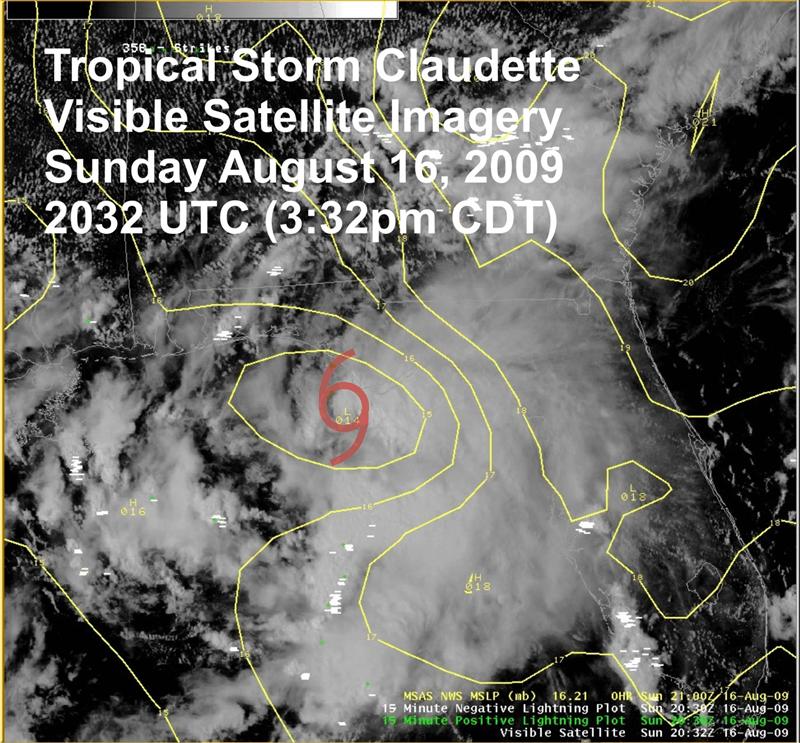
Figure 1. Visible satellite image at 2032 UTC (3:32 pm CDT) showing TS Claudette off the Florida Panhandle coast.
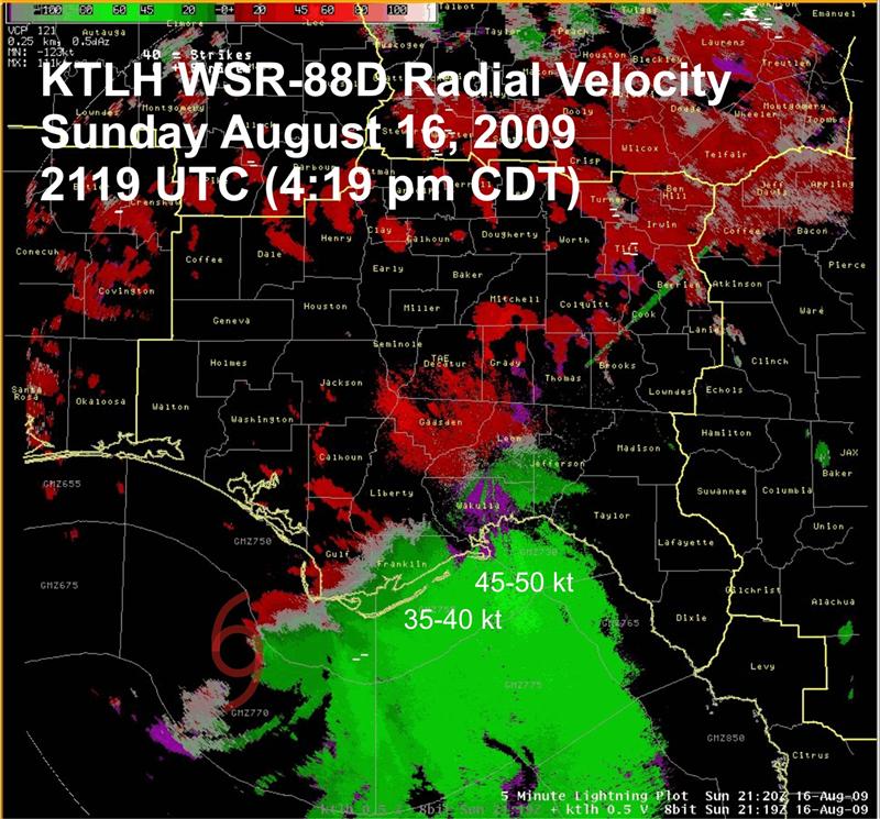
Figure 1 is the visible satellite image at 3:32 pm CDT (4:32 pm EDT), which shows a large canopy of deep layer cloud mainly on the eastern half of the storm. Figures 2 and 3 show the WSR-88D reflectivity and radial velocity images from the Tallahassee (KTLH) radar at 4:19 pm CDT (5:19 pm EDT). The center position of the tropical storm is labeled in each image. On the velocity image( Fig. 3), the regions of highest inbound velocity of 45-50 knots are noted.

Figure 2. Tallahassee Doppler radar (KTLH) reflectivity image on Sunday, 16 August at 2119 UTC (4:19 pm CST) with the center position of TS Claudette indicated.

Figure 3. Tallahassee Doppler radar (KTLH) base velocity image on Sunday, 16 August at 2119 UTC (4:19 pm CST) with the center position of TS Claudette indicated.
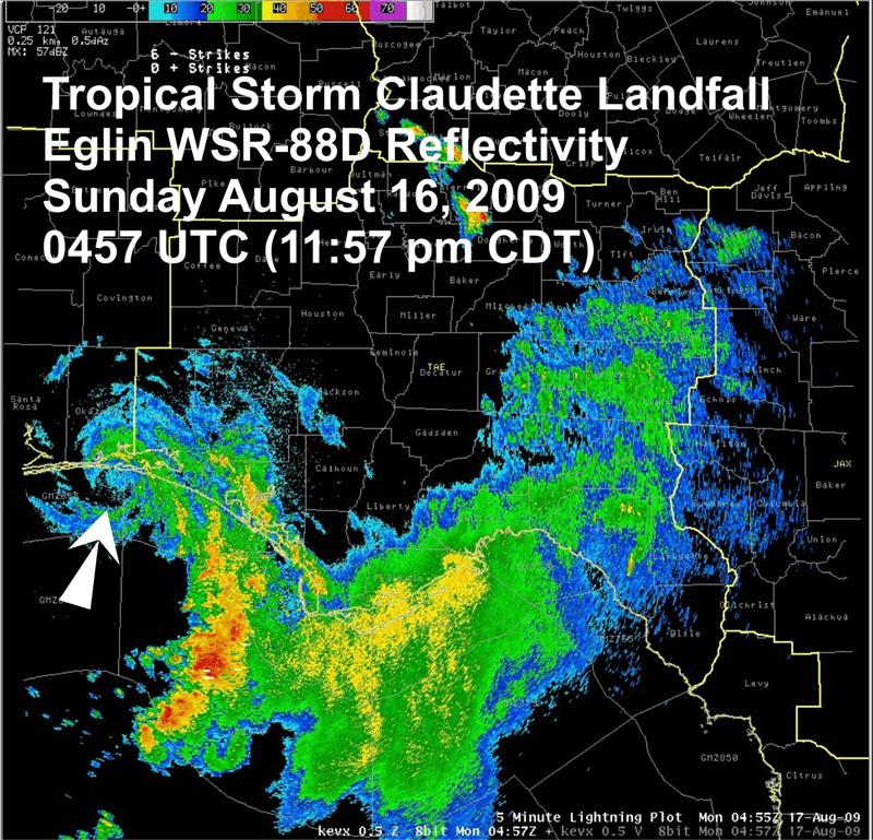
Claudette continued northwest between 12 and 14 mph through the afternoon and early evening hours, finally making landfall around 12:10 am CDT Monday near the eastern end of Santa Rosa Island in Okaloosa County, just southeast of Fort Walton Beach (Fig. 4).

Figure 4. Eglin AFB Doppler radar (KEVX) reflectivity image on Monday, 17 August at 0457 UTC (11:57 pm CST Sunday).
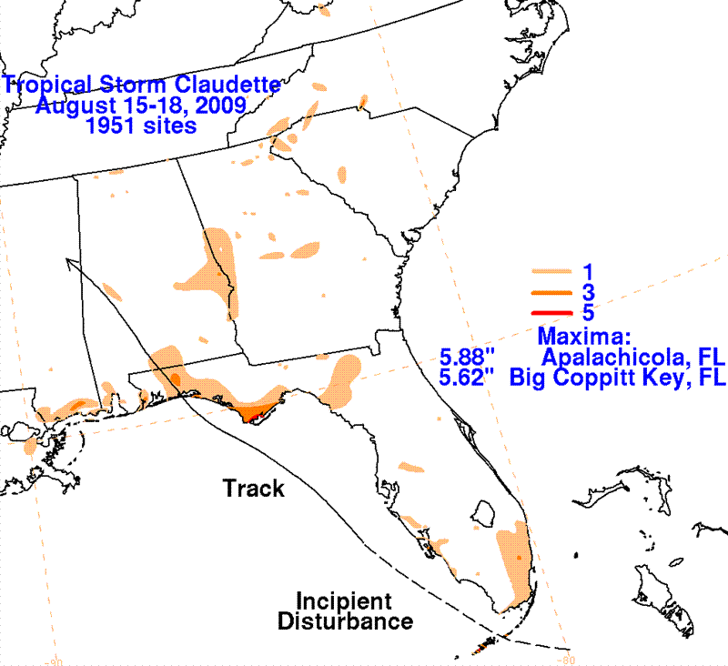
The post tropical cyclone report issued by NWS Tallahassee is linked here. To summarize: A peak gust of 52 knots (60 mph) was reported at C tower about 18 miles south of St. George Island. On land, a peak gust of 45 knots (52 mph) was reported at Apalachicola. Maximum storm tide of 3.5 feet was reported at Indian Pass in Gulf County. Maximum storm total rainfall was reported at Port St. Joe with 4 inches, while Cape San Blas was a close second with 3.93 inches. A three-day total rainfall graphic is included in Figure 5, which shows the impact the system had on the Florida Keys and the limited inland extent of heavy rainfall in the Panhandle. Note, some of the rainfall indicated around Apalachicola occurred in thunderstorms that preceded Claudette.

Figure 5. Three-day rainfall totals from 15-18 August 2009 associated with Claudette from its incipient stage through landfall.