| Heavy Rain and Flooding of February 21-22 |
On Thursday, February 21, 2008, a warm front lifted northward across the northeast Gulf of America and then stalled right along the coast. A series of strong thunderstorms with very heavy rainfall tracked toward the east-northeast just north of the boundary. A flood watch was issued for the entire forecast area. A few of the storms showed some rotation as they crossed the coast (and the front). A water spout was reported at Rosemary Beach in Walton County, with a funnel cloud report coming in just north of Panama City. Numerous special marine warnings were issued throughout the evening. However, the most significant impact came from the training of heavy rainfall producing thunderstorms over the same areas from the eastern Florida Panhandle east-northeast across the Florida Big Bend and far south Georgia. Bay County was hit particularly hard with some 7-10 inches of rain falling that day. This caused widespread flooding across the county, with many roads closed in Panama City. The flooding was so extensive that Bay County schools were closed on Friday. A large area of 4-6 inch rainfall was observed during the evening and overnight hours across the Florida Big Bend. In Tallahassee, a daily rainfall record that had been on the books for 114 years was erased by the 4.99-inch total that fell that day.
The warm front finally began to lift northward late in the evening, taking the heaviest rain with it. However, heavy rains set up again on Friday ahead of a cold front. Fortunately, the largest rainfall totals on this day were just north of where the previous day's heavy rains fell. Still, widespread 2-4 inch totals were reported across the Panhandle, Southeast Alabama, and South Georgia. The 2-day deluge caused area rivers to rise sharply. Many of the rivers in northwest Florida and southwest Georgia surpassed flood stage during the following week, resulting in some flooded roads and homes.
The Storm Data publication summarizes the flood impacts that occurred across the region, especially in the Florida Panhandle.
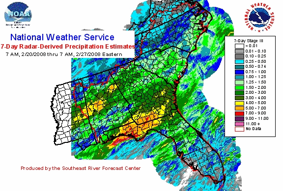
Figure 1 shows the radar-derived rainfall estimates for the week from February 20-27, the vast majority of which fell during this 2-day event.

Figure 1. Two-day radar-derived rainfall estimates for the 7-day period from February 20-27, 2008. Click on the image for a larger view.