The National Weather Service relies on trained volunteers to supplement Doppler radar information on severe storms
and tornadoes. These dedicated individuals volunteer many hours of their time to learn about and detect severe weather.
Their valuable cooperation is important in the warning process. Weather reports from trained spotters are used along
with Doppler radar data to issue warnings of tornadoes, severe thunderstorms, and flash floods.
NOTE: You need to register to attend a class. This training schedule is subject to change. Please visit this website for any last-minute changes or cancellation due to inclement weather etc. You will also be notified via email of any changes.
NATIONAL WEATHER SERVICE PADUCAH SPOTTER PROGRAM:
| CLASS TYPE | DATE/TIME | LOCATION | ADDRESS | PREREQUISITE | REGISTRATION |
| APRIL | |||||
| ELITE SPOTTER | 4/15/2026 6:00 PM |
PRINCETON, KENTUCKY |
State Fire Rescue Training Center District 2 2001 Training Center Drive |
Basic Spotter Course | https://forms.gle/NHK5WcKtfyMSVauh9 |
| ELITE SPOTTER | 4/20/2026 6:00 PM |
BENTON, ILLINOIS | Franklin County EOC 403 E. Main Street |
Basic Spotter Course | https://forms.gle/NHK5WcKtfyMSVauh9 |
| ELITE SPOTTER | 4/27/2026 6:00 PM |
POPLAR BLUFF, MISSOURI |
Three Rivers College 2080 Three Rivers Blvd Robert W. Plaster Free Enterprise Center |
Basic Spotter Course | https://forms.gle/NHK5WcKtfyMSVauh9 |
ABOUT SKYWARN SPOTTERS:
Skywarn FAQs (Frequently Asked Questions)
NATIONAL WEATHER SERVICE PADUCAH COUNTY WARNING AREA:
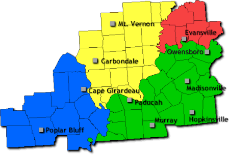
Each National Weather Service office across the U.S. issues forecasts and warnings for and provides weather services for a
particular area of responsibility, known as a County Warning Area or CWA. The counties shown in the graphic below is our area
of responsibility or CWA and therefore our target audience for spotter training classes. If you are outside of this area, please visit
this link and click on your state to find the local NWS contact for your specific county. Some NWS offices may have other criteria
or requirements for you to complete before you can be an official Skywarn Spotter for their area.

SPOTTERS: HOW TO SUBMIT STORM REPORTS:
SPOTTERS: WHAT TO REPORT:
Wind Damage (e.g. trees or tree limbs down, shingles off of buildings etc.)
Wind of 40 to 50 mph or greater
Hail (any size)
Wall Cloud
Funnel Cloud
Tornado
Flooding (water over roads, water rising out of banks of small creek and streams)
Snow or ice beginning to accumulate on roads or other surfaces
Snowfall (about every 1 inch of accumulation)
Freezing Rain (about every 1/4 inch of accumulation and any related damage)
SPOTTERS: WEATHER ANALYSIS TOOLS:
SPOTTERS: ADDITIONAL TRAINING:
ELITE SPOTTER TRAINING:
Elite spotter training normally takes place in early April. See the schedule above for the latest classes scheduled.
The objective of the Elite Spotter Workshops is to develop well trained and safety conscious spotters. Spotters are highly
encouraged to have taken the "Skywarn Spotter Concepts Course" (or a basic spotter course) before attempting to partake
in the Elite Spotter Training. The workshops will be about 3 and 1/2 hours in length, and will include a "Basic Weather 101"
section, more detailed and advanced spotting concepts, radar concepts, safety measures, and hands on exercises. An
end of course exam will be given with a score of 70% required for passing the course and attaining a certificate.
For those wishing to take some basic spotter classes online, or take refresher courses on the material presented
by the NWS, MetEd offers an alternate way to achieve your training. MetEd is populated and maintained by the
COMET®Program, which is part of the University Corporation for Atmospheric Research's (UCAR's) Community Programs (UCP).
You will need to first register for a free account with MetEd. Once you obtain an account and log in, go to Catalog. Do a search for Spotter. You will see the Skywarn Spotter Training Curriculum pop up containing three courses to complete. Once you have completed this training, you may contact christine.wielgos@noaa.gov for instructions on making spotter reports.
SPOTTERS - GUIDES FOR NWS SPOTTERS:
SPOTTERS - REFERENCE MATERIALS:
How to determine your spotter code:
Find the county you live in in the table below, take the SAME code listed next to your county and add the two digits for the year of your last training.
Example: Spotter lives in McCracken county Kentucky and their most recent spotter class was in 2023. Their spotter code would be 21145-23.
| County | SAME Code |
|---|---|
| Alexander, IL | 17003 |
| Ballard, KY | 21007 |
| Bollinger, MO | 29017 |
| Butler, MO | 29023 |
| Caldwell, KY | 21033 |
| Calloway, KY | 21035 |
| Cape Girardeau, MO | 29031 |
| Carlisle, KY | 21039 |
| Carter, MO | 29035 |
| Christian, KY | 21047 |
| Crittenden, KY | 21055 |
| Daviess, KY | 21059 |
| Edwards, IL | 17047 |
| Franklin, IL | 17055 |
| Fulton, KY | 21075 |
| Gallatin, IL | 17059 |
| Gibson, IN | 18051 |
| Graves, KY | 21083 |
| Hamilton, IL | 17065 |
| Hardin, IL | 17069 |
| Henderson, KY | 21101 |
| Hickman, KY | 21105 |
| Hopkins, KY | 21107 |
| Jackson, IL | 17077 |
| Jefferson, IL | 17081 |
| Johnson, IL | 17087 |
| Livingston, KY | 21139 |
| Lyon, KY | 21143 |
| Marshall, KY | 21175 |
| Massac, IL | 17127 |
| McCracken, KY | 21145 |
| McLean, KY | 21149 |
| Mississippi, MO | 29133 |
| Muhlenberg, KY | 21177 |
| New Madrid, MO | 29143 |
| Perry, IL | 17145 |
| Perry, MO | 29157 |
| Pike, IN | 18125 |
| Pope, IL | 17151 |
| Posey, IN | 18129 |
| Pulaski, IL | 17153 |
| Ripley, MO | 29181 |
| Todd, KY | 21219 |
| Trigg, KY | 21221 |
| Saline, IL | 17165 |
| Scott, MO | 29201 |
| Spencer, IN | 18147 |
| Stoddard, MO | 29207 |
| Union, IL | 17181 |
| Union, KY | 21225 |
| Vanderburgh, IN | 18163 |
| Wabash, IL | 17185 |
| Warrick, IN | 18173 |
| Wayne, IL | 17191 |
| Wayne, MO | 29223 |
| Webster, KY | 21233 |
| White, IL | 17193 |
| Williamson, IL | 17199 |