Overview
Thunderstorms developed across the region during the afternoon hours. Some of these were accompanied by damaging winds (64 mph at Murray, KY airport), large hail, and torrential rainfall leading to some flooding, particularly in urban areas and flood prone locations. A second round of storms occurred during the evening hours. Supercells developed over southeast Missouri and produced large hail up to at least ping pong ball size (Scott City, MO) along with damaging winds approaching 70 mph (Poplar Bluff, MO).
Photos
 |
 |
 |
 |
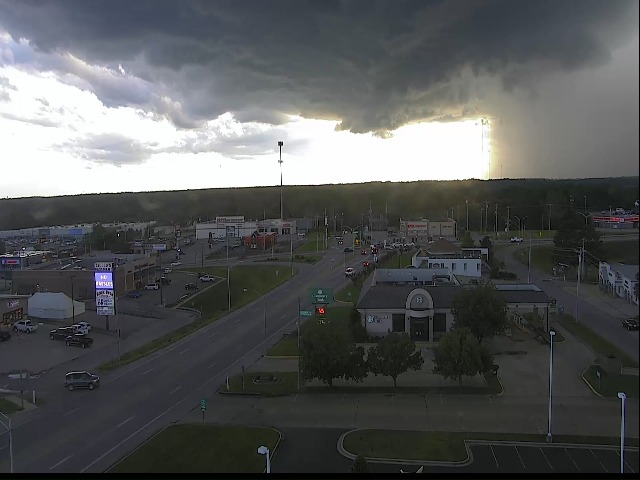
| Storm moving into Poplar Bluff - courtesy of Craig Meador | Plane flipped over at Poplar Bluff Airport - courtesy of Craig Meador | Storm damage in Poplar Bluff - courtesy of Craig Meador | Impressive storm structure looking towards Chaffee, MO - courtesy of Nick Parker |
 |
 |
 |
| Towering storm structure near Fruitland, MO - courtesy of Tyler Brugger | Mammatus Clouds over Cape Girardeau, MO - courtesy of Grant Dade | Rainbow after the storms near Evansville, IN - courtesy of Mike Fetscher |
Warnings
Storm Clusters and line segments moved across the region during the afternoon hours. During the evening hours, a couple of supercells developed in southeast Missouri.
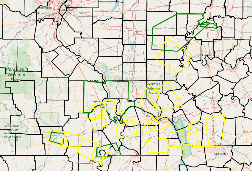 |
| Map of Warning Polygons issued for the event. A total of 20 Severe Thunderstorm Warnings were issued along with 5 Flood Advisories. |
Storm Reports
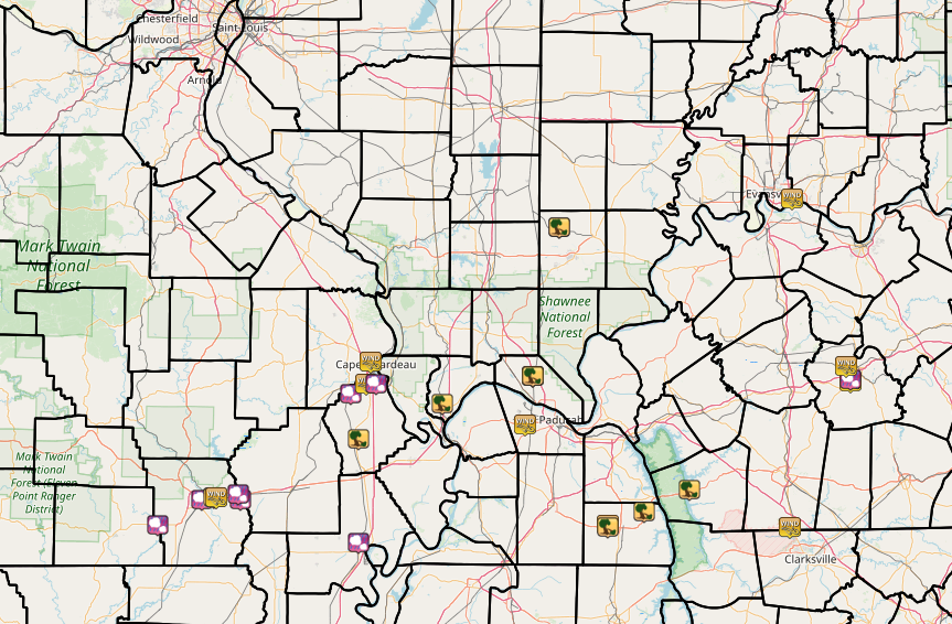 |
| Map of Local Storm Reports issued for this event. Click here for an interactive map |
PRELIMINARY LOCAL STORM REPORT...SUMMARY
NATIONAL WEATHER SERVICE PADUCAH KY
1115 PM CDT WED JUN 19 2019

..TIME...   ...EVENT...      ...CITY LOCATION...     ...LAT.LON...
..DATE...   ....MAG....      ..COUNTY LOCATION..ST.. ...SOURCE....
            ..REMARKS..

0100 PM     HAIL             FARIDEALING             36.66N 90.61W
06/19/2019  E1.00 INCH       RIPLEY             MO   PUBLIC

            RELAYED FROM EM.

0125 PM     HAIL             GALATIA                 37.84N 88.61W
06/19/2019  E0.25 INCH       SALINE             IL   TRAINED SPOTTER

            HEAVY RAIN. ESTIMATE 30-40 MPH WIND.

0130 PM     TSTM WND DMG     GALATIA                 37.84N 88.61W
06/19/2019                   SALINE             IL   PUBLIC

            TREE KNOCKED DOWN WITH ESTIMATED 50 MPH
            WINDS.

0226 PM     TSTM WND GST     CAPE GIRARDEAU          37.31N 89.55W
06/19/2019  M48 MPH          CAPE GIRARDEAU     MO   ASOS


0247 PM     TSTM WND GST     3 W NEWBURGH            37.95N 87.45W
06/19/2019  M45 MPH          VANDERBURGH        IN   TRAINED SPOTTER


0255 PM     TSTM WND GST     ROUND KNOB              37.25N 88.74W
06/19/2019  M55 MPH          MASSAC             IL   TRAINED SPOTTER

            TORRENTIAL RAIN.

0300 PM     TSTM WND DMG     ROUND KNOB              37.25N 88.74W
06/19/2019                   MASSAC             IL   TRAINED SPOTTER

            TREES DOWN IN THE ROUND KNOB AREA. WINDS
            GUSTED TO OVER 60 MPH.

0315 PM     TSTM WND GST     1 SSE POWDERLY          37.23N 87.16W
06/19/2019  M40 MPH          MUHLENBERG         KY   AWOS

            REPORT FROM MUHLENBURG COUNTY AIRPORT.

0315 PM     HAIL             POWDERLY                37.24N 87.16W
06/19/2019  E0.25 INCH       MUHLENBERG         KY   PUBLIC

            ALSO SOME DEBRIS FROM WIND FROM GREENVILLE
            TO POWDERLY.

0315 PM     TSTM WND GST     2 SSE HEATH             37.06N 88.78W
06/19/2019  M39 MPH          MCCRACKEN          KY   ASOS

            REPORT FROM KPAH ASOS - BARKLEY REGIONAL
            AIRPORT.

0423 PM     TSTM WND GST     3 ESE KIRKSEY           36.66N 88.37W
06/19/2019  M64 MPH          CALLOWAY           KY   AWOS

            REPORT FROM KCEY AWOS AT KYLE OAKLEY FIELD.

0430 PM     TSTM WND DMG     4 ESE KIRKSEY           36.65N 88.37W
06/19/2019                   CALLOWAY           KY   TRAINED SPOTTER

            LATE REPORT. 2 TREES AND POWER LINES DOWN AT
            INTERSECTION OF HWY 80 AND COLEMAN TRAIL
            ROAD.

0449 PM     TSTM WND DMG     CANTON                  36.80N 87.96W
06/19/2019                   TRIGG              KY   LAW ENFORCEMENT

            TREES DOWN.

0535 PM     TSTM WND GST     6 N GREENVILLE          37.29N 87.18W
06/19/2019  M47 MPH          MUHLENBERG         KY   MESONET

            REPORT FROM WKU (KENTUCKY) MESONET.

0630 PM     TSTM WND GST     FORT CAMPBELL NORTH     36.65N 87.46W
06/19/2019  M43 MPH          CHRISTIAN          KY   AWOS


0735 PM     HAIL             POPLAR BLUFF            36.76N 90.39W
06/19/2019  M1.00 INCH       BUTLER             MO   BROADCAST MEDIA


0740 PM     TSTM WND DMG     4 E POPLAR BLUFF        36.77N 90.33W
06/19/2019                   BUTLER             MO   TRAINED SPOTTER

            CORRECTS PREVIOUS TSTM WND DMG REPORT FROM 4
            E POPLAR BLUFF FOR TIME OF EVENT. SEVERAL
            TELEPHONE POLES KNOCKED DOWN. NUMEROUS TREE
            LIMBS DOWN. POWER LINES KNOCKED DOWN. PEA
            SIZE HAIL.

0741 PM     TSTM WND GST     5 E POPLAR BLUFF        36.77N 90.32W
06/19/2019  M67 MPH          BUTLER             MO   ASOS

            67 MPH WIND GUST MEASURED AT POPLAR BLUFF
            AIRPORT ASOS.

0755 PM     HAIL             FISK                    36.78N 90.21W
06/19/2019  M1.25 INCH       BUTLER             MO   PUBLIC


0755 PM     HAIL             1 SSE FISK              36.76N 90.20W
06/19/2019  M1.00 INCH       BUTLER             MO   BROADCAST MEDIA


0900 PM     HAIL             LILBOURN                36.59N 89.61W
06/19/2019  E1.00 INCH       NEW MADRID         MO   PUBLIC

            QUARTER SIZED HAIL IN LILBOURN.

0910 PM     HAIL             CHAFFEE                 37.18N 89.65W
06/19/2019  E1.00 INCH       SCOTT              MO   PUBLIC

            NICKLE TO QUARTER SIZED HAIL. WIND ESTIMATED
            AT 30 TO 40 MPH.

0918 PM     TSTM WND GST     2 W SCOTT CITY          37.22N 89.57W
06/19/2019  M48 MPH          SCOTT              MO   ASOS

            REPORT FROM KCGI - CAPE GIRARDEAU MUNICIPAL
            AIRPORT ASOS.

0920 PM     HAIL             SCOTT CITY              37.22N 89.52W
06/19/2019  M1.50 INCH       SCOTT              MO   TRAINED SPOTTER
Additional Information
 |
 |
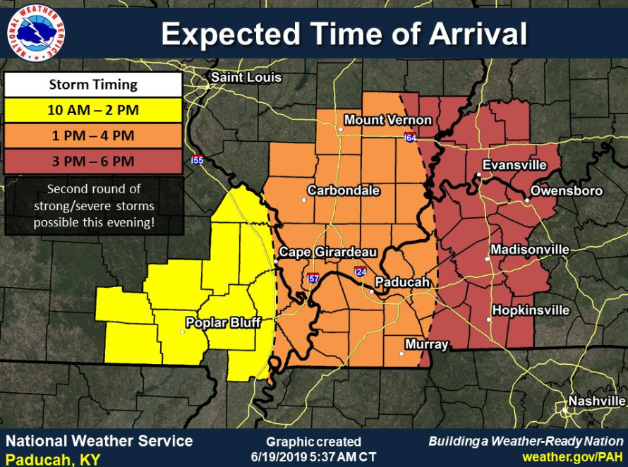 |
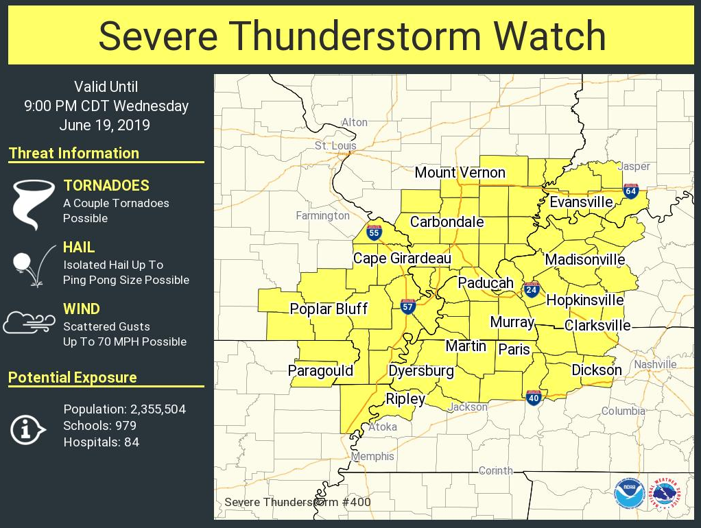
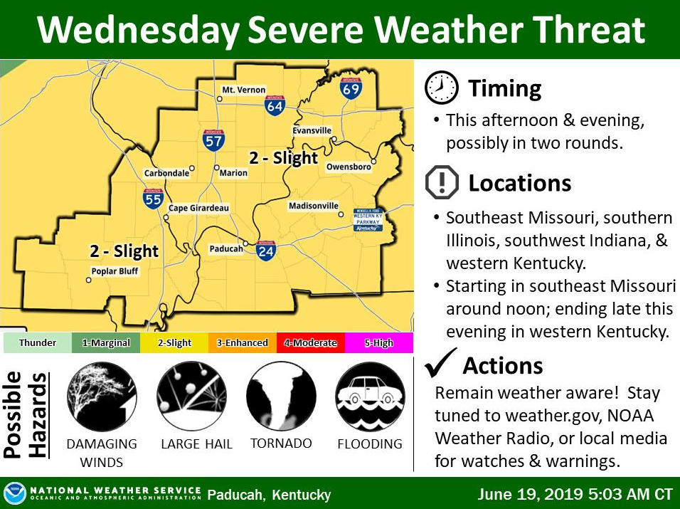
| Severe Thunderstorm Watch Issued at 2 PM | Morning Weather Story with SPC Slight Risk Outlook | Morning graphic showing Time of Arrival of Storms |
 |
Media use of NWS Web News Stories is encouraged! Please acknowledge the NWS as the source of any news information accessed from this site. |
|

