Paducah, KY
Weather Forecast Office
Cyclic Supercell: A thunderstorm that undergoes cycles of intensification and weakening (pulses) while maintaining its individuality. Cyclic supercells are capable of producing multiple tornadoes (i.e., a tornado family) and/or several bursts of severe weather. NOAA Technical Memorandum NWS SR-145: A Comprehensive Glossary of Weather Terms For Storm Spotters.
Supercell: An often dangerous storm that consists primarily of a single, quasi-steady rotating updraft, which persists for a period of time. The supercell typically has a very organized internal structure that enables it to propagate continuously. It may exist for several hours and usually forms in an environment with strong vertical wind shear. Severe weather often accompanies supercells, which are capable of producing high winds, large hail, and strong, long-lived tornadoes. American Meteorological Society: Glossary of Meteorology
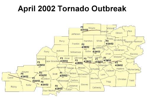
Another more recent example of a cyclic supercell storm was back on April 28th, 2002. One supercell storm produced SEVEN tornadoes across our county warning area. The first tornado occurred in Bollinger County, MO with subsequent tornadoes occurring further east in far southern Illinois and western Kentucky.
FORECASTS
Forecast Discussion
User Defined Area Forecast
Hourly Forecasts
Fire Weather
Activity Planner
LOCAL INFORMATION
Aviation Weather
Our Office
SKYWARN
Items of Interest
Hazardous Weather Support
Local Observations
Weather History
NWS Paducah KY Weekly Partner Briefing
US Dept of Commerce
National Oceanic and Atmospheric Administration
National Weather Service
Paducah, KY
8250 Kentucky Highway 3520
West Paducah, KY 42086-9762
270-744-6440
Comments? Questions? Please Contact Us.

