Record setting heat is expected over the next several days from the Intermountain West through the northern Plains. Furthermore, fire weather concerns increase with dry and breezy conditions. Meanwhile, heavy rainfall and severe thunderstorm threats for the Ohio/Tennessee Valleys, central Appalachians and Southeast today. The threat shifts to central Gulf Coast and across central Texas this week. Read More >
|
Fast Facts:
|
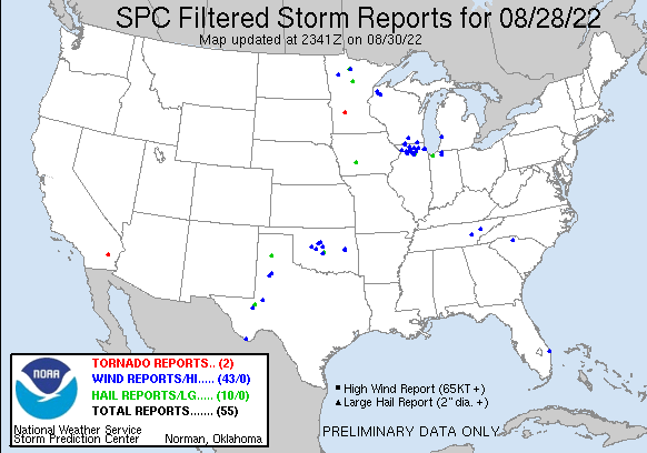
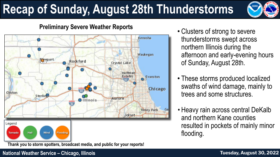 Summary of severe weather and heavy rain reports |
Storm Reports
 |
PRELIMINARY LOCAL STORM REPORT
NATIONAL WEATHER SERVICE CHICAGO IL
816 PM CDT TUE AUG 30 2022

..TIME...   ...EVENT...      ...CITY LOCATION...     ...LAT.LON...
..DATE...   ....MAG....      ..COUNTY LOCATION..ST.. ...SOURCE....
            ..REMARKS..

0222 PM     TSTM WND DMG     1 N POLO                42.00N 89.58W
08/28/2022                   OGLE               IL   PUBLIC

            REPORT OF A 5 INCH THICK 15 FOOT LONG TREE
            LIMB DOWN. NUMEROUS OTHER LIMBS DOWN. TIME
            ESTIMATE.

0240 PM     TSTM WND DMG     DIXON                   41.84N 89.48W
08/28/2022                   LEE                IL   PUBLIC

            PHOTO OF A LARGE LIVE TREE SNAPPED NEAR THE
            BASE.

0251 PM     TSTM WND DMG     1 S OREGON              42.01N 89.33W
08/28/2022                   OGLE               IL   PUBLIC

            FACEBOOK PHOTO OF DOWNED POWER POLE AND
            LARGE TREE LIMBS. TIME ESTIMATED BASED ON
            RADAR.

0311 PM     TSTM WND GST     ROCKFORD AIRPORT        42.20N 89.10W
08/28/2022  M48 MPH          WINNEBAGO          IL   OFFICIAL NWS OBS

            ROCKFORD AIRPORT PEAK WIND.

0312 PM     TSTM WND DMG     4 ENE WINNEBAGO         42.28N 89.17W
08/28/2022                   WINNEBAGO          IL   PUBLIC

            PHOTO SHARED ON SOCIAL MEDIA OF A 2 TO 3
            FOOT DIAMETER TREE SNAPPED AT THE
            INTERSECTION OF MERIDIAN ROAD AND WEST STATE
            STREET. TIME ESTIMATED BASED ON RADAR.

0315 PM     TSTM WND DMG     1 N ROCKFORD AIRPORT    42.21N 89.10W
08/28/2022                   WINNEBAGO          IL   PUBLIC

            SOCIAL MEDIA PHOTO OF TREES DOWN IN A
            BACKYARD. TIME AND LOCATION ESTIMATES.

0319 PM     TSTM WND DMG     1 WNW DAVIS JUNCTION    42.11N 89.12W
08/28/2022                   OGLE               IL   BROADCAST MEDIA

            PHOTOS SHARED OF LARGE LIVE TREE MOSTLY
            UPROOTED AND A FEW LARGE LIMBS DOWN. TIME
            ESTIMATE.

0323 PM     TSTM WND DMG     ROCHELLE                41.93N 89.07W
08/28/2022                   OGLE               IL   TRAINED SPOTTER

            ADDITIONAL LARGE TREE LIMBS DOWN ON 9TH
            AVENUE AND 9TH STREET. ESTIMATED 8 TO 12
            INCHES IN DIAMETER. TIME ESTIMATE.

0324 PM     TSTM WND DMG     ROCHELLE                41.93N 89.07W
08/28/2022                   OGLE               IL   TRAINED SPOTTER

            MULTIPLE LARGE TREE LIMBS DOWN NEAR 10TH
            AVENUE AND LINCOLN HIGHWAY. TIME ESTIMATE.

0350 PM     TSTM WND DMG     4 WNW HERBERT           42.19N 88.84W
08/28/2022                   BOONE              IL   PUBLIC

            TREE LIMBS DOWN. RELAYED VIA SPOTTER
            NETWORK.

0400 PM     TSTM WND DMG     SHABBONA                41.77N 88.88W
08/28/2022                   DE KALB            IL   PUBLIC

            PHOTO SHARED ON SOCIAL MEDIA OF A ROUGHLY 2
            FOOT DIAMETER TREE BLOWN OVER.

0405 PM     TSTM WND DMG     4 NNW WATERMAN          41.82N 88.81W
08/28/2022                   DE KALB            IL   PUBLIC

            PHOTO SHOWS METAL OUTBUILDING/FARM BUILDING
            DESTROYED. TIME ESTIMATED.

0412 PM     HAIL             4 N WATERMAN            41.83N 88.77W
08/28/2022  M1.50 INCH       DE KALB            IL   PUBLIC

            RELAYED VIA SPOTTER NETWORK.

0418 PM     TSTM WND DMG     CORTLAND                41.92N 88.69W
08/28/2022                   DE KALB            IL   PUBLIC

            CORRECTS TIME OF PREVIOUS TSTM WND DMG
            REPORT FROM CORTLAND. SOCIAL MEDIA PHOTO OF
            LARGE TREE LIMBS AROUND 6 INCHES IN DIAMETER
            SNAPPED. TIME AND LOCATION ESTIMATED.

0420 PM     TSTM WND DMG     CORTLAND                41.91N 88.69W
08/28/2022                   DE KALB            IL   TRAINED SPOTTER

            MULTIPLE SIGN POLES BENT OVER DUE TO WIND.
            NEAR SOMONAUK ROAD AND ROUTE 38.

0420 PM     TSTM WND DMG     DEKALB                  41.93N 88.75W
08/28/2022                   DE KALB            IL   TRAINED SPOTTER

            REPORTS OF TWO TENTS BLOWN OVER AT THE
            DEKALB CORNFEST. TIME ESTIMATE.

0420 PM     TSTM WND DMG     1 NW DEKALB             41.94N 88.77W
08/28/2022                   DE KALB            IL   PUBLIC

            TWITTER REPORT OF LARGE LIMB DOWN ON THE NIU
            CAMPUS. TIME ESTIMATE.

0425 PM     TSTM WND DMG     2 N MAPLE PARK          41.94N 88.60W
08/28/2022                   DE KALB            IL   TRAINED SPOTTER

            REPORT OF A ROOF BLOWN OFF A LARGE GRAIN
            SILO. SILO IS APPROXIMATELY 60 FEET TALL AND
            20 FEET WIDE. TIME ESTIMATED BASED ON RADAR.

0451 PM     TSTM WND DMG     LAKE IN THE HILLS       42.18N 88.34W
08/28/2022                   MCHENRY            IL   PUBLIC

            SOCIAL MEDIA PHOTO OF A FEW LARGE (ROUGHLY 6
            TO 12 INCH DIAMETER) LIMBS DOWN. FELL ON AND
            DESTROYED A PORTION OF A METAL FENCE. TIME
            AND LOCATION ESTIMATES.

0505 PM     FLOOD            DEKALB                  41.93N 88.75W
08/28/2022                   DE KALB            IL   PUBLIC

            TWITTER VIDEO OF WATER OVER THE ROADWAY IN
            DOWNTOWN DEKALB.

0530 PM     HEAVY RAIN       3 NE DEKALB             41.96N 88.72W
08/28/2022  M3.30 INCH       DE KALB            IL   TRAINED SPOTTER


0646 PM     TSTM WND DMG     2 SSW DES PLAINES       42.01N 87.90W
08/28/2022                   COOK               IL   DEPT OF HIGHWAYS

            [DELAYED REPORT] NUMEROUS TREE LIMBS WERE
            DOWNED ON THE SOUTH SIDE OF DES PLAINES,
            PARTICULARLY NEAR HOWARD AVENUE UP TO E
            ALGONQUIN ROAD. TIME ESTIMATED BASED ON
            RADAR.

0650 PM     TSTM WND DMG     1 S NILES               42.01N 87.81W
08/28/2022                   COOK               IL   PUBLIC

            SOCIAL MEDIA PHOTOS OF AT LEAST THREE LARGER
            DIAMETER TREES DOWNED IN THE 7300 BLOCK OF W
            GREENLEAF AVENUE BLOCKING THE ROAD. TIME
            ESTIMATED BASED ON RADAR.

0657 PM     TSTM WND GST     GOLF                    42.06N 87.79W
08/28/2022  E60 MPH          COOK               IL   PUBLIC

            VIDEO SHARED VIA TWITTER OF ESTIMATED 60 MPH
            WIND GUST IN GOLF, IL. LOCATION ESTIMATED.


&&

$$
Additional Info
|
|
|
|
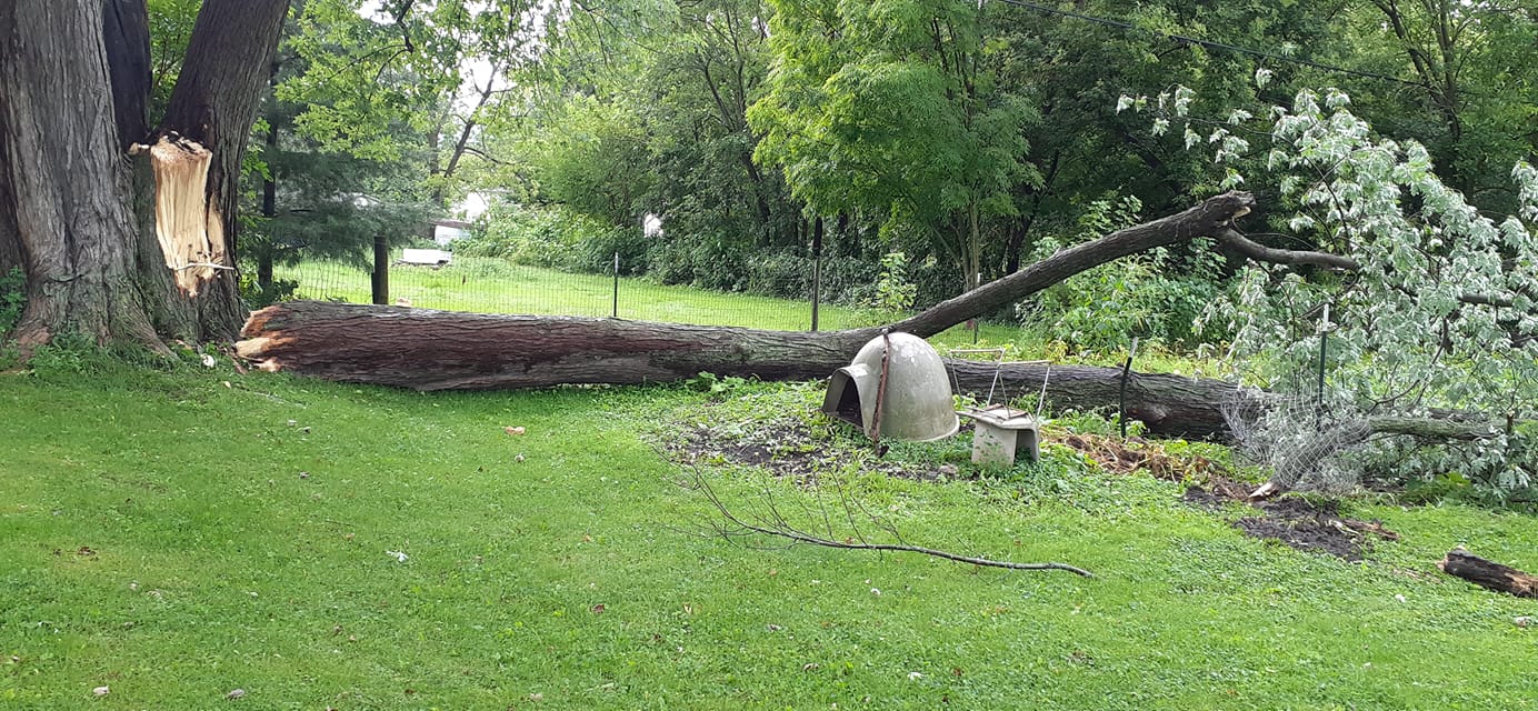
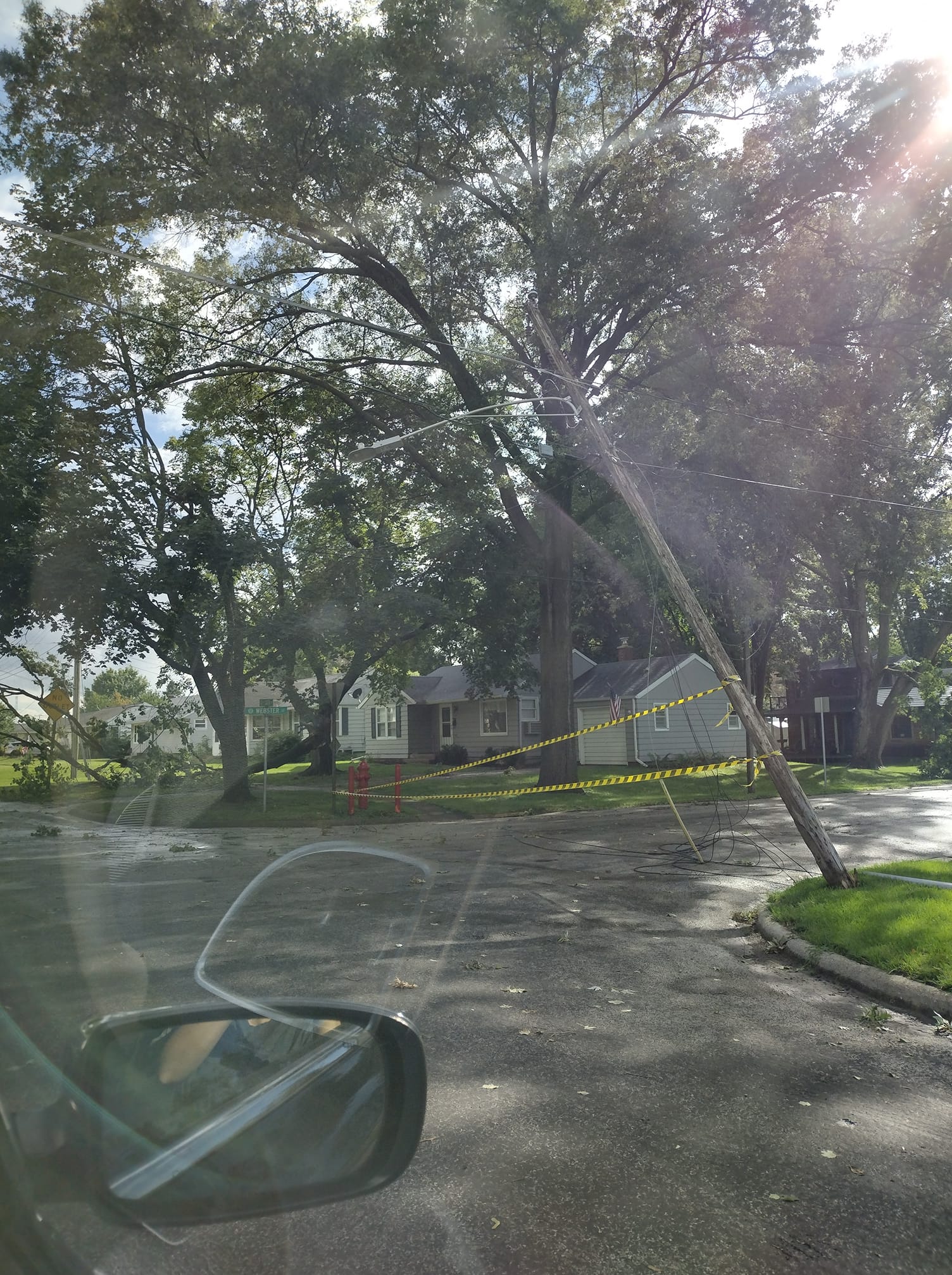
| Tree damage near Rockford. (Carla Winter) | Storm damage in Oregon (Angela Wicklund) | Uprooted tree in Davis Junction (Kris Habermehl) |
 |
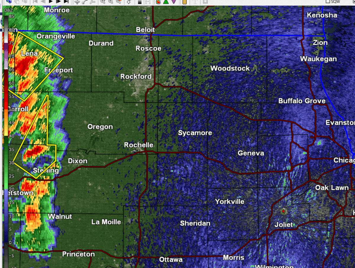 |
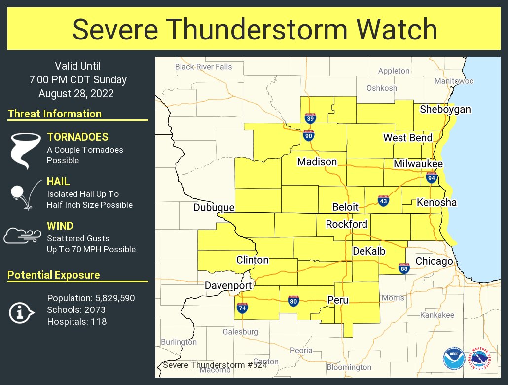
| Initial Severe Thunderstorm Watch issued at 1:15 PM. This watch was later expanded to include Cook, DuPage, Grundy, Will, and Kendall Counties. | Radar loop showing the progression of storms. Severe Thunderstorm Warnings appear as yellow boxes. Special Marine Warnings appear as cyan boxes. |
 |
Media use of NWS Web News Stories is encouraged! Please acknowledge the NWS as the source of any news information accessed from this site. Additional recaps can be found on the NWS Chicago Past Events Page |
|