Overview
Strong winds with and ahead of a cold front brought wind gusts of over 60 mph to parts of central Indiana. This brought down numerous power lines and some trees across the area.Wind:
Selected reports of gusts at or over 40 MPH:
Public Information Statement
National Weather Service Indianapolis IN

...WIND REPORTS...

Location                     Speed     Time/Date
Purdue University Airport    64 MPH    0448 PM 10/20
Indianapolis, In             61 MPH    0601 PM 10/20
Shelbyville Municipal Airpor 58 MPH    0628 PM 10/20
Frankfort                    56 MPH    0515 PM 10/20
Eagle Creek Airpark Airport  55 MPH    0509 PM 10/20
2 NNW Terre Haute            54 MPH    0613 PM 10/20
Delaware County-johnson Fiel 54 MPH    0416 PM 10/20
Mt Comfort Airport           54 MPH    0616 PM 10/20
Columbus Municipal Airport   52 MPH    0704 PM 10/20
Hulman Regional Airport      52 MPH    0532 PM 10/20
Kokomo Municipal Airport     52 MPH    0326 PM 10/20
1 N New Market               51 MPH    0515 PM 10/20
2 NW Crows Nest              47 MPH    0545 PM 10/20
1 ENE Bloomington            47 MPH    0543 PM 10/20
Indianapolis Terry Airport   47 MPH    0515 PM 10/20
Anderson Municipal Apt       46 MPH    0615 PM 10/20
Monroe County Airport        46 MPH    0521 PM 10/20
2 NE Plainfield              45 MPH    0601 PM 10/20
1 ESE Greencastle            45 MPH    0555 PM 10/20
5 NNE Zionsville             45 MPH    0501 PM 10/20
1 NW Ellettsville            44 MPH    0506 PM 10/20
1 SSE New Palestine          44 MPH    0619 PM 10/20
2 NNW Lake Hart              44 MPH    0603 PM 10/20
3 ENE Edinburgh              42 MPH    0543 PM 10/20
4 N Chesterfield             41 MPH    0424 PM 10/20
2 ENE Spring Lake            41 MPH    0549 PM 10/20
Daviess County Airport       41 MPH    0535 PM 10/20
1 SSE Pendleton              41 MPH    0615 PM 10/20
Ball State University        41 MPH    0305 PM 10/20
3 NE Lafayette               40 MPH    0310 PM 10/20
3 SW Westfield               40 MPH    0532 PM 10/20
1 ENE Greenwood              40 MPH    0235 PM 10/20
Storm Reports
PRELIMINARY LOCAL STORM REPORT...SUMMARY
NATIONAL WEATHER SERVICE INDIANAPOLIS IN

..TIME...   ...EVENT...      ...CITY LOCATION...     ...LAT.LON...
..DATE...   ....MAG....      ..COUNTY LOCATION..ST.. ...SOURCE....
            ..REMARKS..

0213 PM     NON-TSTM WND GST 1 W GREENCASTLE         39.64N 86.86W
10/20/2018  M51 MPH          PUTNAM             IN   TRAINED SPOTTER


0333 PM     NON-TSTM WND GST 1 NNW FISHERS           39.97N 86.03W
10/20/2018  E55 MPH          HAMILTON           IN   TRAINED SPOTTER


0338 PM     NON-TSTM WND GST FRANKTON                40.22N 85.77W
10/20/2018  M46 MPH          MADISON            IN   BROADCAST MEDIA

            REPORTED BY CBS4.

0350 PM     NON-TSTM WND GST ELIZAVILLE              40.13N 86.38W
10/20/2018  E50 MPH          BOONE              IN   PUBLIC


0416 PM     NON-TSTM WND GST 2 SW ROYERTON           40.24N 85.39W
10/20/2018  M53 MPH          DELAWARE           IN   ASOS


0424 PM     NON-TSTM WND GST 4 N CHESTERFIELD        40.18N 85.60W
10/20/2018  M41 MPH          MADISON            IN   MESONET

            MESONET STATION AU577, 4 N CHESTERFIELD.

0430 PM     NON-TSTM WND GST 3 NW MULBERRY           40.38N 86.71W
10/20/2018  M60 MPH          TIPPECANOE         IN   PUBLIC

            STATION KINMULBE2. TIME IS APPROXIMATE.

0430 PM     NON-TSTM WND GST 3 WSW DAYTON            40.37N 86.82W
10/20/2018  M58 MPH          TIPPECANOE         IN   PUBLIC

            AT SWIFT FUEL WAREHOUSE. TIME APPROXIMATE.

0431 PM     NON-TSTM WND GST 4 S FRANKFORT           40.23N 86.51W
10/20/2018  M55 MPH          CLINTON            IN   BROADCAST MEDIA

            IN ANTIOCH, IN. REPORTED BY CBS4.

0442 PM     NON-TSTM WND GST 2 SSE NEW PALESTINE     39.70N 85.88W
10/20/2018  M41 MPH          SHELBY             IN   MESONET

            MESONET STATION AV182, 1 SSE NEW PALESTINE.

0443 PM     NON-TSTM WND GST 3 SW SEELYVILLE         39.45N 87.31W
10/20/2018  M52 MPH          VIGO               IN   ASOS


0448 PM     NON-TSTM WND GST 2 SW PURDUE UNIVERSITY  40.41N 86.94W
10/20/2018  M64 MPH          TIPPECANOE         IN   ASOS

            CORRECTS PREVIOUS MARINE TSTM WIND REPORT
            FROM 2 SW PURDUE UNIVERSITY.

0457 PM     NON-TSTM WND GST 2 SW PURDUE UNIVERSITY  40.41N 86.94W
10/20/2018  M63 MPH          TIPPECANOE         IN   PUBLIC


0501 PM     NON-TSTM WND GST 1 NE INDIANAPOLIS INT`L 39.73N 86.28W
10/20/2018  M55 MPH          MARION             IN   ASOS


0509 PM     NON-TSTM WND GST 1 SSE EAGLE CREEK RESER 39.83N 86.29W
10/20/2018  M55 MPH          MARION             IN   ASOS


0509 PM     NON-TSTM WND GST CARMEL                  39.97N 86.11W
10/20/2018  M53 MPH          HAMILTON           IN   PUBLIC

            REPORTED BY CBS4.

0518 PM     NON-TSTM WND GST 3 NE EAGLE CREEK RESERV 39.88N 86.28W
10/20/2018  E50 MPH          MARION             IN   BROADCAST MEDIA


0518 PM     NON-TSTM WND GST 1 SW WEST LAFAYETTE     40.44N 86.92W
10/20/2018  E60 MPH          TIPPECANOE         IN   TRAINED SPOTTER

            TREE LIMBS BROKEN. REGULAR GUSTS TO 60 MPH.

0529 PM     NON-TSTM WND GST TERRE HAUTE             39.47N 87.38W
10/20/2018  E55 MPH          VIGO               IN   AMATEUR RADIO

            NUMEROUS SMALL TREE LIMBS DOWN UP TO ONE
            INCH IN DIAMETER ON THE DRIVE HOME.

0555 PM     NON-TSTM WND DMG 1 NNW FISHERS           39.97N 86.03W
10/20/2018                   HAMILTON           IN   TRAINED SPOTTER

            FEW TREE LIMBS DOWN...1 TO 3 INCHES IN
            DIAMETER.

0601 PM     NON-TSTM WND GST 1 NE INDIANAPOLIS INT`L 39.73N 86.28W
10/20/2018  M61 MPH          MARION             IN   ASOS


0628 PM     NON-TSTM WND GST 3 ESE FAIRLAND          39.58N 85.80W
10/20/2018  M57 MPH          SHELBY             IN   ASOS


0715 PM     NON-TSTM WND DMG 1 SE BEDFORD            38.85N 86.48W
10/20/2018                   LAWRENCE           IN   PUBLIC

            LARGE HEALTHY BRANCHES DOWN...INCLUDING ONE
            ON A UTILITY LINE. DEBRIS BLOWING AROUND
            SUCH AS TRASH CANS...LIGHT SIGNAGE...AND
            CARDBOARD. LARGE ROAD CONSTRUCTION
            BARRICADES BLOWN OVER.
Environment
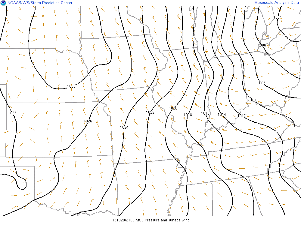
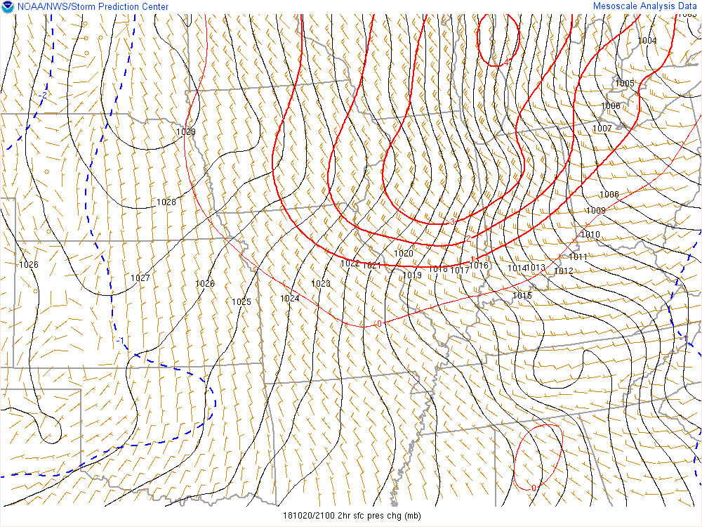
Much cooler air moved in behind a cold front. This plus strong winds throughout the lower atmosphere led to some of these winds mixing down to the ground.
 |
 |
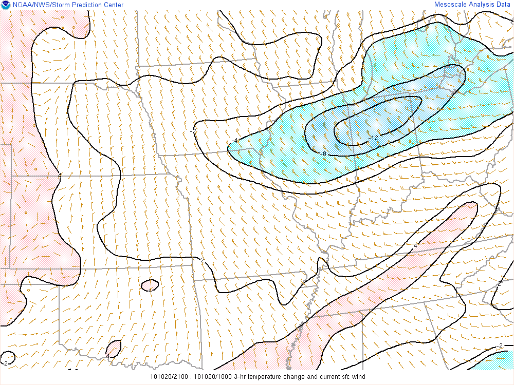 |
| Figure 1: Surface Pressure & Winds at 5 PM EDT | Figure 2: Surface Pressure Change at 5 PM EDT | Figure 3: Surface Temperature Change at 5 PM EDT |
 |
Media use of NWS Web News Stories is encouraged! Please acknowledge the NWS as the source of any news information accessed from this site. |
|

